Showing 5020 items
matching crown
-
 Phillip Island and District Historical Society Inc.
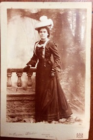
Photograph, Portrait of Annie Reid nee Saunders, Circa early 20th century
A local identity of Rhyll, Phillip IslandFull length sepia photograph mounted on cardboard of woman in long, dark dress and pale coloured hat. Posed in a studio.Annie Reidlocal identity, annie reid nee saunders, photograph, portrait -
 Lorne Historical Society
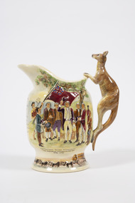
Souvenir - Musical jug, Crown Devon Fieldings, c. 1935
Bone China jug, with kangaroo shaped handle with hand painted relief scenes First Nations Peoples brandishing spears at Captain Cook’s sailors, Captain Cook taking possession of the country at Botany Bay April 1770 The words to Advance Australia Fair are also printed . Along the base is a color painted relief of a bullock cart containing logs.souvenirs, captain cook, botany bay, advance australia fair, indigenous, kangaroo, endeavour -
 Greensborough Historical Society
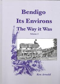
Book, Crown Castleton Publishers, Bendigo Its Environs - the Way it Was. Vol 3 / by Ken Arnold, 2013_
A brief history of the areas of Strathfieldsaye, Junortoun, Longlea, Axedale, Kimbolton, Redesdale, Lyal, Myrtle Creek, Axe Creek, Eppalock, Emu Creek, Sedgwick, Mandurang, Mandurang South and Diamond Hill.399 pages, illus. Hard cover.bendigo -
 Greensborough Historical Society
Map, Victoria. Department of Crown Lands and Survey, Keelbundoora; Counties of Bourke and Evelyn, 1950c
Map of the Victorian counties of Bourke and Evelyn showing parish boundaries and land ownership.Show the original landholders for this area.Map on light brown parchment, covered in plastic."L.5305" and "3462" -
 Kiewa Valley Historical Society
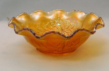
Bowl Carnival Glass, circa early 1900s
This particular glass bowl was a favoured ornamental type room "brightener" in the early 1900's. Although referred to as a "nappy bowl" this bowl has not the capacity for nappies but for nappy pins. This was a period in time before the nappy ties and instant nappy covers.This has relevance as an object that was both practical for the early 1900's nappy changes and provided some visual relief for any "drab" household ambience, especial in rural homes. The early to mid 1900's, rural households, on the whole, were more practical and not designed for entertainment. This reflected the more serious nature which were governed by aspects of providing a living from the land and unreliable weather. By placing visually attractive ornaments within various rooms (lounge/living rooms) the transformation from a stark external environment to a more warm and friendly area was achieved. This dark amber (Marigold) carnival glass 5 inch nappy bowl has a Kookaburra press molded base and wattle blossom with waratah and flannel flower sides. The bowl has a twelve scolloped rippled rim. Initially this type of bowl was reintroduced(from Roman times) into the 19th and 20th Century (modern age) by a United States glass manufacturer..Manufacturer's mark at the base illegible nappy bowls, nappy pin holders, visual mood changing ornaments -
 4th/19th Prince of Wales's Light Horse Regiment Unit History Room
Photograph, The Crown Mission (?), Pte P E Butler, c. 1915
A sepia photo/postcard of 65714 Pte P. E. Butler of C Coy 18th GSRAdressed: C/O Mr E Thompson 254 Lordship Lane East Dulwich, London, England.photo, p e butler -
 Orbost & District Historical Society
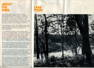
pamphlet, Lake Tyers Forest Park, 1960's
This pamphlet would have been produced as a tourist guide to East Gippsland.This item is a useful reference tool.A three fold glossy, pamphlet titled"Lake Tyers Forest Park". It contains information, a map and black / white photographs of Lake Tyers Park. Print colours are brown, white, yellow and black.pamphlet lake tyers-forest-park -
 Orbost & District Historical Society
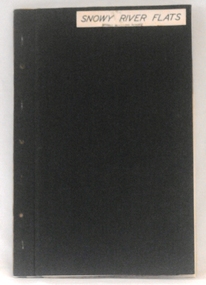
plans, 1966?
These survey plans are a useful research tool.A flat green fabric folder with a white label with "SNOWY RIVER FLATS" hand-written in black. It contains plans.plans-survey snowy-river-flats department-crown-lands-victoria -
 Orbost & District Historical Society
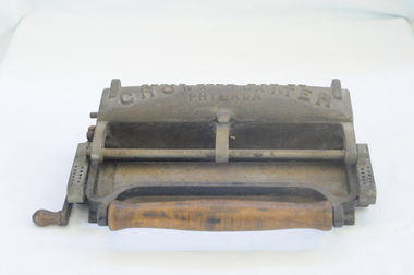
pleating machine, late 19th century - early 20th century
Pleated ruffles were a fashionable trimming for ladies’ clothing in the late 19th century - early 20th century. Dressmakers and classy laundries offering “fancy” ironing services both had plenty of use for a pleating machine. Pleating machines were sold for home use too.This item is an example of a machine not commonly used today.Metal and wood pleating machine, still in working order. Handles are carved wood.textile-machinery sewing pleating-machine -
 Federation University Historical Collection
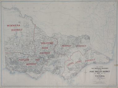
Plan, Map Showing the Pastoral Holdings of the Port Phillip District 1835-1851 Now Victoria, 1932, 1932
Another name for Pastoral Holdings is squatting runs. Information on Alfred Stephen Kenyon of the Historical Society of Victoria can be found at http://adb.anu.edu.au/biography/kenyon-alfred-stephen-6936/text12035 Map of Victoria showing the boundaries of the Port Phillip District (Victoria) pastoral boundaries. pastoral holdings, squatters, squatting, victoria, land, crown lands, a.s. kenyon, alfred stephen kenyon -
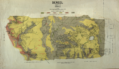 Federation University Historical Collection
Map, Dereel, County of Grenville, 1890, 1890
Dereel is in western Victoria.Geological map of Dereel in the County of Grenville featuing six colours (predominantly grey and yellow). WGS 84 Centroid Lat: 37 degrees 48 feet 50 inches S Long:143 degrees 42 feet 10 inches S N-S: 6.4 km E-W: 15.2 km dereel, ferdinand krause, crown lands department, plan -
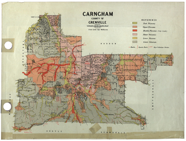 Federation University Historical Collection
Plan, Carngham, County of Grenville
A plan of Carngham, Victoria.snake valley, timber reserve, poverty point, recreation reserve, carngham, county of ripon, county of grenville, plan -
 Federation University Historical Collection
Plan, Parish of Dowling Forest, County of Ripon and Grenville, 19
Scale [1:31 680]. 40 chains to 1 in.Geological map on a cadastral base, showing the occurence of reefs, and alluvial deposits. Relief shown by contours.dowling forest, wyndholm, wyndholm pre-emptive right, miners rest, ballarat racecourse, winter's swamp, police reserve, miner's rest, winters swamp, geology -
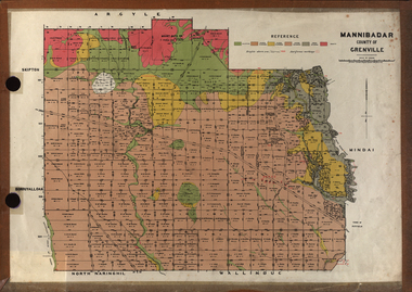 Federation University Historical Collection
Plan, Mannibadar Geological plan
Coloured plan of Mannibadar, County of Grenville.mannibadar, pitfield, mount bute, emu hills, woady yalouk river, geology, plan -
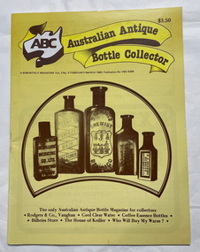 City of Moorabbin Historical Society (Operating the Box Cottage Museum)
Magazine, Arnold, Ken, Australian Antique Bottle Collector, 1985
An Australian bi-monthly magazine for collectors of Antique Bottles.Yellow cover with photos of amber glass chemist bottles An Australian bi-monthly magazine for collectors of Antique Bottles.antique bottles, collections -
 Monbulk RSL Sub Branch
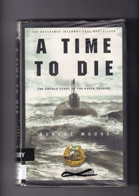
Book, Robert Moore, A time to die: The untold story of the Kursk tragedy, 2002
At 11:28 a.m. on Saturday, August 12, 2000, high in the Arctic Circle under the roiling surface of the unforgiving Barents Sea, Captain Gennady Lyachin was taking the Kursk, the pride of Russia's elite Northern Fleet, through the last steps of firing a practice torpedo, part of an elaborate naval exercise. Suddenly, the torpedo exploded in a massive fireball, instantly incinerating all seven men in the submarine's forward compartment. The horror, however, was just beginning. The full, gripping story of the remarkable drama inside the Kursk and of the desperate rescue efforts has never been told - until now.Index, ill (b/w plates), p.362.non-fictionAt 11:28 a.m. on Saturday, August 12, 2000, high in the Arctic Circle under the roiling surface of the unforgiving Barents Sea, Captain Gennady Lyachin was taking the Kursk, the pride of Russia's elite Northern Fleet, through the last steps of firing a practice torpedo, part of an elaborate naval exercise. Suddenly, the torpedo exploded in a massive fireball, instantly incinerating all seven men in the submarine's forward compartment. The horror, however, was just beginning. The full, gripping story of the remarkable drama inside the Kursk and of the desperate rescue efforts has never been told - until now.russian submarine kursk explosion, submarine disasters - russia -
 Wangaratta RSL Sub Branch
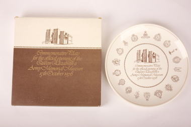
Commemorative Plate, Crown Lynn Potteries Limited, 1978
Round white ceramic plate with various royal, imperial and military gold emblems bordering an image of a brown building. Original cardboard box has also been retained.Front: "Commemorative Plate for the official opening of the Queen Elizabeth II Army Memorial Museum 15th October 1978" Back: "Queen Elizabeth II / Army Memorial Museum Plate / This plate has been created as one of 2,000 only, to commemorate the official opening of the Queen Elizabeth II Army Memorial Museum in Waiouru, by the Governor-General, Hist Excellency the Rt Hon Sir Keith Holyoake, GCMG, CH, on the 15th October 1978. / This plate design was authorised by the Chief of General Staff, Major General R.D.P. Hassett, CB, CBE, and approved by the New Zealand Herald of Arms. / 319"ceramic, commemorative plate, army memorial museum plate, army memorial museum -
 Victorian Aboriginal Corporation for Languages
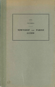
Book, Department of Crown Lands and Survey Victoria, Township and parish guide : Victoria, 1955
A alphabetical list of townships proclaimed under the Land Acts of Victoria. Shows the parish, land district and the municipality in which each is situated, and the particulars of Gazettal of Proclamation.victorian geographical names, victorian administration -
Yarrawonga and Mulwala Pioneer Museum
Manual - Instruction manual, Crown Separator Company, "Sylvia" Separators
Used during the 1950'sInstruction book for setting up and operating of the milk separator. Also includes part numbers so they can be ordered to replace worn parts See photos -
 Bayside Gallery - Bayside City Council Art & Heritage Collection
Map, Department of Crown Lands and Survey et al, Moorabbin, County of Bourke, Government Roads, 1920
The cadastral map of the Parish of Moorabbin in Victoria (L.6104) shows parish boundaries and land ownership 1920 when Sandringham was a Town. The government roads have been coloured in red pencil.moorabbin, county of bourke, map, plan, land subdivision, land titles, foreshores, hampton, beaumaris, highett, cheltenham, department of lands and survey, land owners, cartographic material, brighton, sandringham, town of sandringham, government roads -
 Bayside Gallery - Bayside City Council Art & Heritage Collection
Map, Department of Crown Lands and Survey, Moorabbin, County of Bourke, c. 1918
The cadastral map of the Parish of Moorabbin in Victoria (L.6104) shows parish boundaries and land ownership c. 1918 when Sandringham was a Borough.moorabbin, county of bourke, map, plan, land subdivision, land titles, foreshores, sndringham, hampton, beaumaris, highett, cheltenham, department of lands and survey, land owners, cartographic material, borough of sandringham, brighton -
 Bayside Gallery - Bayside City Council Art & Heritage Collection
Map, Department of Crown Lands and Survey, Melbourne and Suburbs, City of Sandringham, 1917-1926
map, plan, foreshores, sndringham, hampton, beaumaris, cheltenham, department of lands and survey, cartographic material, borough of sandringham, moorabbin, black rock, street map, city of sandringham -
![Collecting Australian Found Bottles, Glass Part 1 / [by] Ken Arnold](/media/collectors/550653872162f11fb04854aa/items/5d0345ef21ea7b095050c6e9/item-media/5ebc912ca9d32b09e4a4c599/item-fit-380x285.jpg) Kew Historical Society Inc
Kew Historical Society IncBook, Collecting Australian Found Bottles, Glass Part 1 / [by] Ken Arnold, c. 1985
127 p. : ill., facsimsbottles - collectors and collecting - australia -
RMIT GSBL Justice Smith Collection
Report, Sallmann, Peter et al, Report on document destruction and civil litigation in Victoria, 2004
May 2004ISBN: 0646435787evidence preservation -- victoria, evidence (law) -- victoria, civil litigation, document destruction -
 Wodonga & District Historical Society Inc
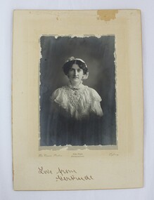
Photograph - Hamilton-Smith Collection Photograph of Gertrude Foord c. early 1900s, The Crown Studios: Vice-Regal Photographers
The Hamilton-Smith collection was donated by the children of Grace Mary Hamilton-Smith nee Ellwood (1911-2004) and John Hamilton-Smith (1909-1984) who settled in Wodonga in the 1940s. The Ellwood family had lived in north-east Victoria since the late 1800s. Grace’s mother, Rosina Ellwood nee Smale, was the first teacher at Baranduda in 1888, and a foundation member of the C.W.A. Rosina and her husband Mark retired to Wodonga in 1934. Grace and John married at St. David’s Church, Albury in 1941. John was a grazier, and actively involved in Agricultural Societies. The collection contains significant items which reflect the local history of Wodonga, including handmade needlework, books, photographs, a wedding dress, maps, and material relating to the world wars. This photograph is of Gertrude Foord (1885-1968), an aunt on the Hamilton-Smith family tree. Much of the needlework and textiles in the Hamilton-Smith collection belonged to Gertrude. This item has well documented provenance and a known owner. It forms part of a significant and representative historical collection which reflects the local history of Wodonga. It contributes to our understanding of social and family life in early twentieth century Wodonga, as well as providing interpretative capacity for themes including local history and social history.Black and white studio portrait photograph of a woman dressed in early 1900s dress, mounted on card.Handwritten inscription in bottom centre: "Love from/Gertrude". photograph, family photographs, photo, 1900s, edwardian, studio portrait, portrait -
 Federation University Historical Collection
Map - Geological Survey, J. Phillips, Geological Survey of Victoria - Ballarat, 1857, 10/1858
Geological map of the Ballarat District featuring four colours.ballarat, geological, geology, geological plan, main road, camp, golden point, pennyweight hill, clayton hill, ballaarat cemetery, bakery hill, specimen hill, soldiers hill, nightingale lead, native youth black hill flat, white flat, mining, mines, eureka lead, old post office hill -
 Eltham District Historical Society Inc
Document - Map, Victoria. Department of Crown Lands and Survey, Town of Eltham, Parish of Nillumbik, County of Evelyn, 2 October 1929
Township of Eltham, Parish of Nillumbik, County of Evelyn / lithographed at the Department of Lands & Survey Melbourne 5th June 1888, amended 2 October 1929 This amendment from the 1888 original shows the reserve for the the State School marked as permanent with dimensions added to Main Road and block frontages along Main Road between Mount Pleasant Road and Dalton Street and Metery Road Possibly photocopied from a copy held at PROV by Harry Gilham whilst resaerching Eltham Primary School history in 1995.a. armstrong, a. lavard, arthur c. allan, arthur c. allen, b. bowatere, baxter street, benjamin oliver wallis, bolton steet, c. souter, c.s. hain, cemetery reserve, charles brown, charles newman, charles symons wingrove, christopher caldwell, church of england, d. anderson, dalton street, david ballard, e. james, e.m. peck, edward dumaresq, eltham town, ely street, f.e. falkiner, f.m. peck, falkiner street, flint street, g. buckingham, g. drabble, george stebbing, godalmin street, h. peck, h.c.whess, h.h. farquharson, h.j. bews, henry stooke, j. goer, j. mcdonald, j. mclaren, j. roberts, j.b. knagers, james irish, jane bailey (nee matthews), john l. smith, john mason, john scott, john smith, joseph stevenson, joseph verse, k. wingrove, k.e. dunstan, kerby street, kirby street, location tbd, m. coman, map, michael o'shea, o.b. mccutcheon, p. & g. tumbull, p.k. mccaughan, p.p. cotter, porter street, pound reserve, robert hepburn, roman catholic church, s. evans, samuel dagley, samuel phillips, samuel ramsden, t. upton, t. watkins, t.a. stark, t.c.b. batt, t.p. cross, thomas grant, thornton street, w. adam, w. blain, w. long, w. watkins, w.f. ford, w.h. hull, w.r. belcher, w.t. schultz, william thomas, eltham primary school, eltham state school, eltham state school no. 209, quarry reserve -
Lakes Entrance Historical Society
Book, Margaret Herd editor, Crown Content publisher, Who's Who in Australia, 2002
Since 1906 Whos Who in Australia has been regarded as the authoritative reference to notable people in AustraliaISSN 0810 8226 ABN 37096393636people -
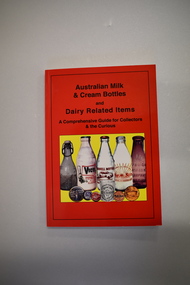 Warrnambool and District Historical Society Inc.
Book, Australian Milk and Cream Bottles, 2008
This book contains information on milk and cream bottles and other dairy-related items. It includes photographs of local milk and butter factories – Warrnambool (Allansford), Grassmere, Koroit, Garvoc, Glenormiston and Byaduk and references to Warrnambool milk suppliers – Antarctic Ice, Tooram and H Lindsay. No details have been found on H. Lindsay, selling milk in the 1920 to 1940 period. Antarctic Ice had a pasteurising plant in Kepler Street in the 1930s and sold to Warrnambool Cheese and Butter and Kraft in partnership and milk was sold under the new label, Sungold Dairies. They then purchased the Kaye Ryan pasteurizing plant in Verdon Street. Kraft moved out of the partnership with Warrnambool Cheese and Butter and Sungold Dairies relocated to the Allansford factory site where they still operate today. Tooram was the name of the property established in the Allansford area by the pioneer settler, John Allan. By the 1860s Tooram had become well-known for its cheese making and in the 1880s Tooram, owned by Thomas Palmer, had what was described as the finest dairy farm in Victoria. This book is of interest as it contains information on milk and cream bottles and dairy-related items and Warrnambool is the centre of an important dairying industry with the Warrnambool Cheese and Butter Factory in Allansford being the oldest existing dairy product factory in Australia. The book will be very helpful to researchers. This is a soft cover book of 224 pages. The cover has a red background with black printing and a colour image of five bottles and five other dairy-related items on the front cover and colour images of four bottles, a tin and three labels or signs on the back cover. The contents include text on milk and cream bottles and allied material and colour and black and white photographs. dairying in western district of victoria, warrnambool district dairying, history of warrnambool, sungold dairies, tooram -
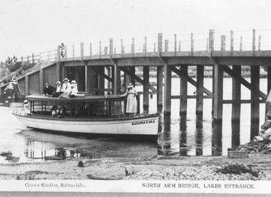 Lakes Entrance Historical Society
Photograph - Maranui 2, Crown Studios Bulmer, 1917c
Concrete bridge over North Arm, constructed by Coate Bros. opened September 1917. Also Maranui Guest House history.Black and white photograph of a tourist launch named Maranui 2 beside the North Arm Bridge. People on launch dressed in summer clothing of pre WW1 era. Posts and steel rope rails on bridge. Low tide indicated by height of bridge piers out of the water. Lakes Entrance Victoria boats and boating, bridges, clothing