Showing 4074 items matching " surveying"
-
 Peterborough History Group
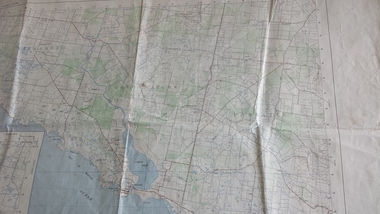
Map - Government map, Government Printer, Port campbell, 1957
Aerial survey map showing roads, vegetation and other landscape features.Significant because it shows the detail of the region in 1957Original 1957 State Aerial Survey Map of Port Campbell region, including Peterboroughpeterborough, aerial survey map, maps, port campell -
 Bendigo Historical Society Inc.
Map - GEOLOGICAL MAP OF BENDIGO GOLD FIELD
Two framed laminated maps (a,b) of Bendigo goldfield reef lines, map (b) is a continuation of the reef lines in map (a). On map(a) written in black on top: 'Geological Map, Bendigo Gold Field', Scale of chains, anticlines, synclines, shafts, alluvial and contours marked. Map (b) is continuation of (a). Written on the bottom RH corner of map: 'Prepared in 1923 in the Bendigo Office Mines Department under the direction of H. Herman, Director of Geological Surveys, from surveys by H.S. Whitelaw, Fiield Geologist, assisted by E.S. Usher & J. J. Moore. Re-issued in 1936.'H. Herman, Director of Geological Surveys, from surveys by H.S. Whitelaw, Fiield Geologist, assisted by E.S. Usher & J. J. Moore. Re-issued in 1936.'bendigo, mining, geological map. -
Whitehorse Historical Society Inc.
Map, Blackburn East Primary School
Proposed master plan 1955?Proposed master plan 1955? With Public Works Dept. detail survey 1979. Rolled map.Proposed master plan 1955? blackburn east primary school no. 4800, public works department -
 University of Melbourne, Burnley Campus Archives
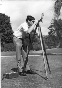
Photograph - Black and white print, Information Branch, Victorian Department of Agriculture, Student Using Dumpy Level, 1967
... surveying ...Note by T.H. Kneen 18 December 1991, "Student using dumpy level is Adrian Wells (1968)."2 copies black and white photograph. Student using surveying equipment in Burnley grounds.On reverse stamp, "Photograph by Information Branch Victorian Department Of Agriculture Ref. No. D.1100.F."students, adrian wells, 1968, surveying, students working outside, dumpy level, publicity -
Whitehorse Historical Society Inc.
Map, Parish of Nunawading, 1927
Map of the Parish together with part of the Borough of Box Hill.Map of the Parish together with part of the Borough of Box Hill. Includes names of lease or license holders, sizes of leases and in some areas dates of leases. Roads, railway and stations marked. Original survey by W.J.Busocon, 1915. Manuscript note: 15.2.1927 Verified Dept. Lands and Survey.Map of the Parish together with part of the Borough of Box Hill. maps, parish of nunawading, borough of box hill -
 Bendigo Military Museum
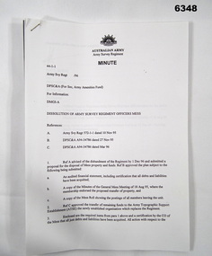
Administrative record - Dissolution of Army Survey Regiment Officers Mess, Army Survey Regiment, Bendigo, 1995
The Royal Australian Survey Corps was disbanded in 1996, and as a result the Army Survey Regiment Officers Mess was also disbanded. This minute describes the administrative procedures for the dissolution of the Officers Mess Army survey Regiment Minute 44-1-1, 30 pages A4 paper stapled top left cornerroyal australian survey corps, rasvy, fortuna, army survey regiment, army svy regt, asr -
 Bendigo Military Museum
Photograph - Central Comd Fd Svy Unit at the Army Survey Regiment, 1966
This photograph of the Central Command Field Survey Unit, Field Survey Detachment was taken in front of the Survey building at Keswick Barracks in Adelaide, South Australia c1966. DR Ridge (later LTCOL) front Centre, SPR RJ Hayden top Right.This is a photograph of the C Comd Fd Svy Unit at the Army Survey Regiment, Bendigo. The photograph was printed on photographic paper and is part of the Army Survey Regiment’s Collection. The photograph was scanned at 300 dpi. .1) Photo, black & white 1966. Front Row to L to R: 5th MAJ Don Ridge. All other personnel are unidentified..1 - “C Comd Fd Svy Unit 1966” annotated on backroyal australian survey corps, rasvy, army survey regiment, army svy regt, fortuna, asr -
Federation University Historical Collection
Plan, Ballarat Common, c 1890
Hand drawn ink plan or field notes for a survey on faintly ruled foolscap paper. Field notes or survey depicting Ballarat Commons, Ballarat Botanical Gardens, Police Paddock and Ballarat Cattle Yards Railways area. 'R.W.' at bottom, Verso 'Ballarat' with various calculations. -
 Bendigo Military Museum
Letter - Royal Australian Survey Corps Jubilee, Department of Defence, Melbourne, 1965
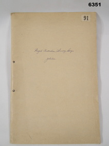
The folder about the Royal Australian Survey Corps Jubilee, contains a number of very informative letters dealing with the formation of the Army Survey Corps. There is also some history as to how the Australian Survey Corps came into being. One letter lists the current units of the Royal Australian Survey Corps.Foolscap size manila Folder containing a number of letters held together by an ARNOS fastener.No "91" Top right hand corner. "Royal Australian Survey Corps Jubilee" hand written on front coverroyal australian survey corps, rasvy, fortuna, army survey regiment, army svy regt, asr -
 Bendigo Historical Society Inc.
Map - HUSTLERS LINE OF REEFS - LONGITUDINAL SECTION THROUGH THE SADDLE REEFS
Drawing with Longitudinal Section through the Saddle Reefs along portion of Hustler's Line of Reefs, Bendigo. Map shows the depth of the mines, reef numbers and Datum 700 ft above sea level. North and South is also noted on the map. Map signed by H. S, Whitelaw, Underground Survey Office, Bendigo, September 1913. Bulletin No 33, Plate No XXXIV. Bendigo Creek, Ironbark Creek and Long Gully are also noted. Mines are: Fortuna Hustlers, Hustler's Royal Reserve No 2 Main Shaft, Hustler's Royal Reserve No 2 Park Shaft, Royal Hustler's, Imperial Hustler's, Extended Hustler's Freehold, Great Extended Hustler's Tribute (Pups), Old Shaft, Great Extended Hustler's Reef No 2, Great Extended Hustler's Main Shaft, Old Shaft, Hustler's Reef, Hustler's Reef No 1, Comet, K. K., United Hustler's & Redan, Old Shaft and Hustler's Consols. Has Geological Survey of Victoria Crest and underneath is: H. Herman, Director, W. Dickson, Secretary for Mines, The Hon. J Drysdale Brown M L C. Minister of Mines.Geological Survey of Victoria Crestmining, hustler's reef maps, hustlers line of reefs, bendigo creek, royal hustler's, imperial hustler's, extended hustler's freehold, great extended hustler's tribute (pups), great extended hustler's reef no 2, great extended hustler's main shaft, hustler's reef, hustler's reef no 1, united hustler's & redan, old shaft and hustler's consols.h s whitelaw, underground survey office bendigo september 1913 -
 Bendigo Military Museum
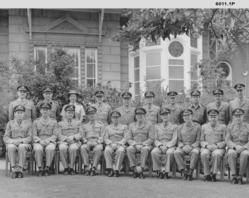
Photograph - Royal Australian Survey Corps Planning Conferences, Army Survey Regiment, Bendigo, 1962, 1964, 1966, 1967, 1972, 1973
The Bi Annual Planning Conferences were to plan and coordinate the activities of the Royal Australian Survey Corps. The conferences were chaired by the Director of the Survey Corps and were attended by representatives from all elements of the Corps. The conferences were held at the Army Survey Regiment Fortuna Villa Bendigo . 1) Black and white photograph of the attendees at the Royal Australian Survey Corps Planning Conference November 1964 taken outside Fortuna Villa. Conference Chairman Brigadier Don Macdonald AM, MID Director of the Survey Corps. .2) Black and white photograph of the attendees at the Royal Australian Survey Corps Biennial Planning Conference November 1966 taken at Fortuna Villa. Conference Chairman Brigadier Don Macdonald AM, MID Director of the Survey Corps. .3) Black and white photograph of the attendees at the Royal Australian Survey Corps Biennial Planning Conference November 1966 taken in the Ball Room at Fortuna Villa. Conference Chairman Brigadier Don Macdonald AM, MID Director of the Survey Corps. Conference in progress. .4) Black and white photograph of the attendees at the Royal Australian Survey Corps Planning Conference November 1967 taken outside at Fortuna Villa. Conference Chairman Brigadier Frank Buckland OBE, MID; Director of the Survey Corps. .5) Black and white photograph of the attendees at the Royal Australian Survey Corps Biennial Planning Conference 1962 taken in the gardens of Fortuna Villa. Conference Chairman COL Don Macdonald AM, MID Director of the Survey Corps. Back Row L to R: LT M. Gler, LT F. Thorogood, LT. W.A Gillard, CAPT W.P. Constantine, MAJ E.U. Anderson, MAJ. J.K. Nolan, MAJ N.R.J. Hillier, CAPT W. Greer, MAJ. M.A. Marks, LT. G. Roy. Front Row L to R: 2T F. High, MAJ C.T. Carter, MAJ T. C. Sargent, MAJ J. L. Stedman, MAJ F.D. Buckland, LTCOL C.S. Tyler, COL D. Macdonald, LTCOL W.B. Relf, MAJ H.M. Hall, MAJ L.B. Sprenger, MAJ G.H. Tomlinson, MAJ S.W. Snow. .6) Black and white photograph of the attendees at the Royal Australian Survey Corps Biennial Planning Conference c1972 taken in the gardens of Fortuna Villa. Conference Chairman COL John K. Nolan, Director of the Survey Corps. .7) Black and white photograph of the attendees at the Royal Australian Survey Corps Biennial Planning Conference 05th October 1973 taken in the gardens of Fortuna Villa. Conference Chairman COL John K. Nolan, Director of the Survey Corps. Back Row L to R: MAJ Laker, SQNLDR Porter, CAPT Clues, SQNLDR McCormack, MAJ Eddy, FLTLT O’Loghlin, MAJ Illingworth, MAK Laing, MAJ Thorogood, MAJ Millar, CAPT Mason. Front Row L to R: MAJ Taylor, MAJ Ricketts, LTCOL Anderson, WGCOMD Whitely, LTCOL Ridge, MAJ Dalton, MAJ Todd..1 Nov 64 written on back, .2 RA Svy - Biennial Conference Nov 66 annotated on front, .3 Biennial Conference Nov 66 annotated on back, .4 RA Svy Planning Conference - Nov 67 annotated on front, .5 All officers annotated at footnotes on front, 6. No annotations, 7. All officers annotated on back and dated 5 Oct 73royal australian survey corps, rasvy, fortuna, army survey regiment, army svy regt, asr -
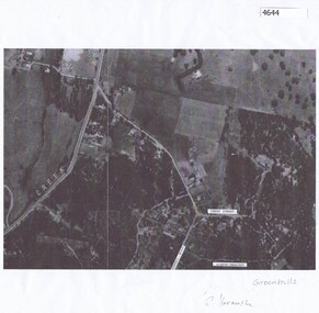 Greensborough Historical Society
Aerial Photograph, Greenhills Aerial View, 1945_
Section from the 1945 aerial survey of Greensborough, including part of Diamond Creek Road, Greenhill Road, Crest Street and Albion Crescent.Photocopy of part of 1945 aerial survey. Some streets have been marked.greenhills -
 Bendigo Historical Society Inc.
Document - LANDS OFFICE, REPORTS OF SALES BY PUBLIC AUCTION, 1864 - 1892
Document: buff leather hard covered journal. On spine on red rectangle ' Land sales by public auction' written in gold. On bottom of spine 'Lands and Survey' written in gold on black. On base of spine '4' printed in black. Pages contain details of sales of crown lands by public auction Act 25, Victoria 145. Alphabetical index of counties inside front cover. 443 numbered pages. LH side columns, number, county, parish, section, allotment sold, unsold, price. RH page - improvements, purchaser, residence, amount, later sales have printed notices pasted in. Dated 27 April 1864 to 7 October 1892.Lands and Survey Dept.place, bendigo, sandhurst, crown land, public land auctions, land sales. -
 Bendigo Military Museum
Photograph - Visit to Army Headquarters Survey Regiment, Fortuna, Bendigo by D-SVY COL Frank Buckland OBE, c1971
This photo of WO2 Don Taylor and D-SVY COL Frank Buckland OBE was taken during a tour by D-SVY through Topographic Squadron at the Army Headquarters Survey Regiment, Fortuna, Bendigo circa 1971. Wild B8 Aviograph Stereoplotters are visible inside the windows in the background. BRIG Frank Buckland OBE served in the Australian Army from 01 June 1938 to 31st of October 1972. LTCOL Frank Buckland was the CO of the Army Headquarters Survey Regiment from 1962 to 1965. After promotion to COL Buckland was appointed as Director of the Royal Australian Survey Corps from March 1967 to August 1972. COL Buckland was promoted to Brigadier (retired) to the honorary position as Colonel Commandant from January 1973 to January 1976. WO2 Don Taylor served in the Australian Army from 24th October 1960 to 31st December 1987 and ended his service as a commissioned officer and reached the rank of Major. He was the OC of 4th Field Survey Squadron, Adelaide SA for several years.This photograph of the Royal Australian Survey Corps (D-SVY) COL Frank Buckland OBE was taken during a D-SVY tour through Topographic Squadron, at the Army Headquarters Survey Regiment, Fortuna, Bendigo circa 1971. The black and white photograph was printed on photographic paper and is part of the Army Survey Regiment’s Collection. The photograph was scanned at 300 dpi. .1) - Photo, colour, c1971, L to R: WO2 Don Taylor, Director of the Royal Australian Survey Corps COL Frank Buckland OBE. There are no annotations.royal australian survey corps, rasvy, army survey regiment, army svy regt, fortuna, asr -
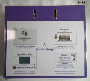 Bendigo Military Museum
Document - Quadrilology on aspects of Royal Australian Survey Corps mapping by Dr Bob Williams, Dr Bob Williams, 2024
A4 purple two ring folder that contains four illustrated articles about the Royal Australian Survey Corps written by Dr Bob Williams. Article 1. A brief history from a memorable event in 1915 - Gallipoli. A tribute to Australia's Military Mapmakers Videre Parare Est, 1910-2000. Article 2. Fortuna's role in the story, Reflections of a military mapmaker. Military Mapmakers of "Fortuna" The house of the Army Survey Regiment - Royal Australian Survey Corps. Article 3. A Political Imperative - An amazing surveying and mapping operation. Impossible to Map! Papua New Guinea. Article 4. Military Mapmakers. The farther backward you can look; the farther forward you can see. Dr Bob Williams served in the Royal Australian Survey Corps from 1965 as a Sapper in the Royal Australian Survey Corps and retired from the Army in 1991 as a Major to join DSTO continuing his career in the spatial sciences. A4 purple two ring folder that contains four illustrated articles about the Royal Australian Survey Corps written by Dr Bob Williams. Article 1. A brief history from a memorable event in 1915 - Gallipoli. A tribute to Australia's Military Mapmakers Videre Parare Est, 1910-2000. Article 2. Fortuna's role in the story, Reflections of a military mapmaker. Military Mapmakers of "Fortuna" The house of the Army Survey Regiment - Royal Australian Survey Corps. Article 3. A Political Imperative - An amazing surveying and mapping operation. Impossible to Map! Papua New Guinea. Article 4. Military Mapmakers. The farther backward you can look; the farther forward you can see.royal australian survey corps, rasvy, fortuna, army survey regiment, army svy regt, asr -
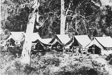 Halls Gap & Grampians Historical Society
Photograph - B/W
Railway survey camp 1880 After choosing the route, the rail survey was undertaken followed by the construction of the line in less than a year. By Nov 1881 access by rail for Heatherlie to Melbourne was a reality Railway survey camp Heatherlie quarry; 11 men, some standing, some reclining in front of 6 army style tentsstructures, tents -
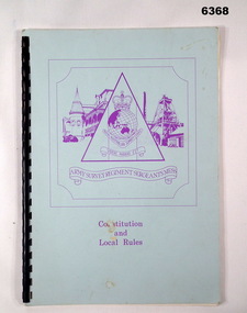 Bendigo Military Museum
Administrative record - Army Survey Regiment Sergeants Mess - Constitution and Local Rules, Army Survey Regiment Sergeants Mess, Bendigo, Aug 1985
This booklet sets out the Constitution of the Sergeants Mess at the Army Survey Regiment, Bendigo. It also includes all the Local Rules that apply to the Mess.Light blue carboard covered booklet containing A4 paper pages with plastic ring binding. The Army Survey Regiment Sergeants Mess Logo is printed in purple on the cover. Purple is the Corps Colour of the Royal Australian Survey Corps.royal australian survey corps, rasvy, fortuna, army survey regiment, army svy regt, asr -
 Bendigo Military Museum
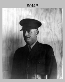
Photograph - Royal Australian Survey Corps - LT Wilfred John Harrison, c1940s
This is a photograph of 566 WX31826 LT W.J. Harrison. Wilfred John Harrison enlisted in the Permanent Military Force on the 24 Apr 1939 in Western Australia at the rank of WO2. He was one of the fifty Permanent Force members of the Australian Survey Corps as of 3 Sep 1939. WO2 Harrison’s first unit was No 3 Survey Section, located in the 2nd Military District, New South Wales. It is not known when he was commissioned as an officer. He retired at the rank of Lieutenant from the AMF on 15 Dec 1949.This is a photograph of LT Wilfred John Harrison, a member of the Royal Australian Survey Corps, taken in the 1940s. The photograph was printed on photographic paper and is part of the Army Survey Regiment’s Collection. The photograph was scanned at 300 dpi. .1P – There are no personnel identified.royal australian survey corps, rasvy, fortuna, army survey regiment -
 The Beechworth Burke Museum
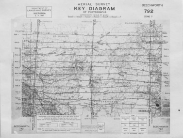
Photograph - Aerial Survey, 5/9/1947
This image is an Aerial Survey, Key Diagram of Beechworth and surrounding area. Issued by Department of Lands and Survey, Victoria in 1947. Photographed at an average height of 12300 feet above sea level, areas depicted are; Beechworth, Stanley, Bruarong, Baranduda, Muagegonga, Myrtleford, Everton, Wooragee North Tarrawinge, Dederang, Kergunyah North, Kergunyah, Yackandandah, El-Dorado, Barambogie, Murmungee, Barwidgee, Oxley, CarraragarmungeeBlack and white rectangular photograph. Image is printed on matt photographic paper and has a white un-printed border. Obverse: AERIAL SURVEY, KEY DIAGRAM OF PHOTOGRAPHS, APPROXIMATE SCALE OF MILES / DEPARTMENT OF LANDS AND SURVEY VICTORIA 5.9.1947. BEECHWORTH 792 ZONE 7. Reverse: BMM7010.1 (written in pencil) aerial survey, beechworth, burke museum, department of lands and survey, victoria, 1947 -
Tatura Irrigation & Wartime Camps Museum
Book, Adolf Wilke, 15 September 1944 - 1 May 1946
... Surveying ...Surveyors book compiled by POW Adolf Wilke who was lecturer in surveying at Camp 13, Murchison.Handmade hard cover, hand stitched book consisting of figures and plans in ink and pencil. 69 numbered pages.adolf wilke, surveying, camp 13 surveying -
 Bendigo Historical Society Inc.
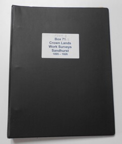
Photograph - CROWN LANDS WORK SURVEYS 1895 - 1926
... surveying ...Black folder contains 14 buff coloured foolscap booklets in individual plastic pockets, listing crown lands work surveys in Bendigo. Pages are handwritten.hospital, bendigo, crown lands work survey, surveying, land -
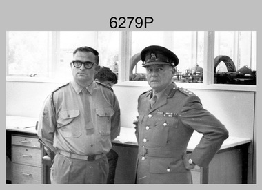
 Bendigo Military Museum
Photograph - LTCOL Jorge Gruszka – Commanding Officer Army Survey Regiment, c1982-1985
These photographs were taken at the Army Survey Regiment, Bendigo in c1985. LTCOL Jorge Gruszka was the Commanding Officer from 1982 to 1985.This is a set of three photographs of LTCOL Jorge Gruszka, CO of the Army Survey Regiment Army Survey Regiment, Bendigo c1982-1985. The photographs were printed on photographic paper and are part of the Army Survey Regiment’s Collection. The photographs were scanned at 300 dpi. .1) - Photo, black & white, c1982-1985, LTCOL Jorge Gruszka. .2) and .3) - Photo, colour, c1982-1985, LTCOL Jorge Gruszka. .1P to .3P – Incorrectly identified on back as George Gruszkaroyal australian survey corps, rasvy, army survey regiment, army svy regt, fortuna, asr -
 Bendigo Military Museum
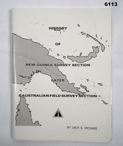
Booklet - History of the New Guinea Survey Section 1967 by LT Jack Viccars, Lt Jack Stewart Viccars, Circa 1967
Military surveying in New Guinea began in in WWII with the formation of the New Guinea Force Field Survey Section which later became 8th Australian Field Survey Section and later 2 Field Survey Section of 6th Army Topographical Survey Section. This history was written by LT Jack Viccars and member of the Unit.A4 Booklet, Black and white, 43 Pages, 4 Annexes, Map Indexes, Gloss Paper Cover, Bound by staplesForward by Brigadier D. Macdonald (Retd) AM, Royal Australian Survey Corps 1936-1967, Preface by LT Jack J.S. Viccarsroyal australian survey corps, rasvy, fortuna, army survey regiment, asr -
 Bendigo Military Museum
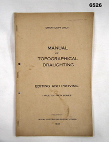
Document - Royal Australian Survey Corps - Manual of Topographical Draughting - Editing and Proving 1949, Royal Australian Survey Corps, 1949
This Draft document is part of the Topographical Drafting Manual produced by the Royal Australian Survey Corps in 1949. This document covers the guidelines for Editing and Proving (quality control) of the 1 Mile to 1 Inch map series that was widely produced by the Corps over Australia.A 10 x page foolscap sized buff coloured covered document, stapled and two hole punchedStamped on cover "E Comd Field Survey Unit"royal australian survey corps, rasvy, fortuna, army survey regiment, army svy regt, asr -
 Bendigo Military Museum
photograph - Aerotriangulation Production – Army Survey Regiment, Fortuna, Bendigo, c1980
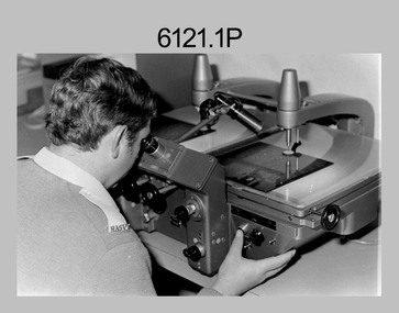
This collection of five photos was most likely taken in 1980. Wild PUG4 point transfer devices were used by technicians in Air Survey Squadron to stereoscopically view the photography containing the survey control points and the mapping aerial photography. The Control points were transferred from the control photography to the mapping diapositives of aerial photography by drilling their locations into the photographic emulsion. The Zeiss (Jena) Stecometer analytic stereocomparator for air photography was introduced at Air Survey Squadron in 1963. Aerotriangulation production was expedited using computers for analytical photogrammetric processes. The technician accurately measured between pass, tie, and survey control points on aerial photographs.Air Survey Squadron Aerotriangulation Section - Army Survey Regiment, Bendigo. c1980. This is a set of five photographs of Air Survey Squadron personnel operating aerotriangulation equipment at the Army Survey Regiment at Fortuna, Bendigo, c1980. Photographs .1P to .4P are on 35mm negative film and were scanned at 96 dpi. Black and white photo .5P is on photographic paper and was scanned at 300 dpi. They are part of the Army Survey Regiment’s Collection. .1) - Photo, black & white, c1980, Wild PUG4 point transfer device, unidentified technician. .2) - Photo, black & white, c1980, Wild PUG4 point transfer device, unidentified technician. .3) - Photo, black & white, c1980, Wild PUG4 point transfer device, unidentified technician. .4) - Photo, black & white, c1980, Zeiss (Jena) Stecometer, unidentified technician. .5) - Photo, black & white, c1980, Zeiss (Jena) Stecometer..1P to .5P No personnel are identified.royal australian survey corps, rasvy, army survey regiment, army svy regt, fortuna, asr, air survey, aerotrig -
 Bendigo Military Museum
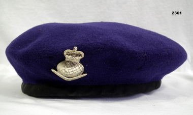
Headwear - BERET & RASVY BADGE, Christies, Beret and Royal Australian Survey Corps Badge
This "Purple" Beret sold by Christies in Sydney was produced for the Queensland Ex Survey Corps Association and was not authorised for Service use. The authorised Royal Australian Survey Corps beret was dark blue. The "purple" beret was and is used extensively around Australia on ceremonial occasions such as Anzac Day.Beret, woollen, purple colour with a gold anodized badge - Crown over globe, boomerang with Royal Australian Survey Corps.uniforms - army, costume - male, headwear, numismatics-badges, military, royal australian survey corps, rasvy -
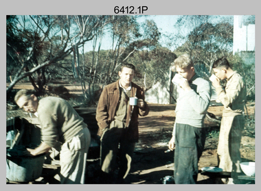 Bendigo Military Museum
Photograph - Royal Australian Survey Corps Surveyors in the Field – Victoria, 1956 - 1958
... surveying ...This is a set of two photographs of surveyors and support staff in the field undertaking tasks in Victoria 1956 – 1958. The surveyors were employed in the establishment of mapping and geodetic control. In this era surveyors used theodolites to observe horizontal and vertical angles and chains to measure base line distances between survey stations. This is a set of 23 photographs of surveyors and support staff in the field undertaking duties in Victoria 1956 – 1958. The photographs were printed on photographic paper and are part of the Army Survey Regiment’s Collection. The photographs were scanned at 300 dpi. .1) - Photo, colour, 1956. Surveyors enjoying a tea break. L to R: Tom Gilbert (cook), Barry Broad, Tony Slattery, John Van De Graff. Taken at Boonoonar, a locality south of Mildura. .2) - Photo, colour, 1958. Surveyors taking a break from driving. L to R: Leo Bub, Bob Thompson. Taken at Puckapunyal..1P to .2P annotated on back – personnel names, the year and the location. royal australian survey corps, rasvy, army survey regiment, asr, army svy regt, fortuna, surveying -
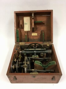 Creswick Campus Historical Collection - University of Melbourne
Equipment - Surveying equipment in fitted timber box
Surveying equipment in fitted timber box. 2 components of solid brass painted dark green. Missing one additional component. Additional lens.Surveying equipment in fitted timber box. 2 components of solid brass painted dark green.T.004 -
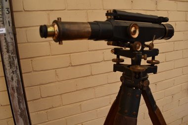 Tatura Irrigation & Wartime Camps Museum
Dumpy Level, Dumpty Level, 1920
... surveying ...Used by Mr. Craven to survey agricultural land in the Goulburn Valley for the purposes of setting out farm irrigation channels and check banksStanlley Dumpy Level on tripod, complete with carrying case and sixteen foot telescopic staffPatent Stanlley, Great Turnside, Holborn, London 11182surveying, irrigation, terrestrial -
Whitehorse Historical Society Inc.
Map, Burwood Road, Box Hill City, 15/02/1952 12:00:00 AM
Plan of subdivision of ten blocks in Burwood Road, Burwood.Plan of subdivision of ten blocks in Burwood Road, Burwood between Milford Avenue and Station Street. Marked as Survey Plan No 5441.Plan of subdivision of ten blocks in Burwood Road, Burwood. land subdivision, burwood road, burwood, milford avenue, burwood, central court, burwood