Showing 564 items matching "bacchus"
-
![Map, [Coornmill land area available for leasing for grazing, Parish of Coornmill]. Circa 1904](/media/collectors/5e461d8021ea67224c82f2a1/items/677cde147f2053f3e5d277c3/item-media/677cdeea7f2053f3e5d27bb4/item-fit-380x285.jpg) Bacchus Marsh & District Historical Society
Bacchus Marsh & District Historical SocietyMap, [Coornmill land area available for leasing for grazing, Parish of Coornmill]. Circa 1904
... Shire of Bacchus Marsh ...This map shows an area of land north of Bacchus Marsh in the Larderderg State Park area known as the Parish of Coornmill.The map indicates an area of land which was to be made available by public tender for grazing leaseholders. The plan to do this was discussed in the Bacchus Marsh Express newspaper on the 16 July, 1904, page 2, column 7. The area reserved for grazing leases is identified by red lines on the map. The Express described the area available for grazing was 12,000 acres.A single page paper map showing an area of land in the Parish of Corrnmill to be made available for grazing leases. A photo lithographed Lands Department Map. No scale indicated. The map is pasted into a bound volume containing 76 maps or plans in total. High resolution digital image stored on BMDHS computer network. coornmill parish maps, lerderderg state park maps, agriculture bacchus marsh area -
 Bacchus Marsh & District Historical Society
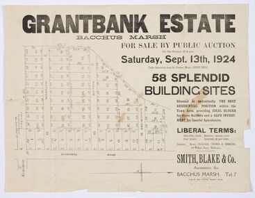
Map - Land Sales Plan, Grantbank Estate Bacchus Marsh, 1924
... Grantbank Estate Bacchus Marsh ...The Grantbank Estate was a parcel of land close to the centre of the shopping area of Bacchus Marsh which was sub-divided and offered for sale in 58 lots on the 13th September, 1924. It comprised an area of 15 acres, being a portion of the Millbank Estate which had been in the hands of the Grant family for 75 years. The lots had frontages to Gisborne Road, Patterson, William and Sutherland Streets. This was a significant sub-division of land and represented a major expansion of residential housing in Bacchus Marsh in the early 20th century.This land sale map is a typical example of housing estate land sales advertising maps produced by real estate agents in this era. The map is significant for the detailed information it provides about when and where land was sold for new housing estates in Bacchus Marsh in the early twentieth century.Printed paper mapland sales bacchus marsh, land subdivsion bacchus marsh, housing estates land sales bacchus marsh, grant family bacchus marsh -
 Bacchus Marsh & District Historical Society
Map, Balliang Parish Map, County of Grant c.1907
... Shire of Bacchus Marsh ...A single page paper map showing parish plan map for Balliang. This parish area contains the localities of Balliang and Balliang East and is located south of the township of Bacchus Marsh. The map is pasted into a bound volume containing 76 maps or plans in total. High resolution digital image stored on BMDHS computer network. balliang victoria maps, balliang parish maps -
 Federation University Historical Collection
Photographs - Colour, Meeting of the Course Advisory Committee for Librarianship, 1988, 09/06/1988
... Bacchus Marsh, Central Victoria, Victoria, Australia ...Librarianship Advisory Committee, meeting 09/06/1988 at Bacchus March Municipal Library. .1) An assembled group of 3 female and 6 male persons in a library staff room , standing behind two tables with teacups and sandwiches Bignall, Pam. BCAE Course. Mansfield, P, Librarian: CHRLS. Hitchins, Bill, Librarian: BCAE. Ooms, Jean. Library Officer: Bacchus March Municipal Library. Fryar, Peter. Dean Faculty of Human Studies: BCAE. Ringkat, Thelma. Head Librarianship Department: BCAE. Cotsell, Ray. Lecturer: Librarianship, BCAE. Groenegen, Hans. Managing Director CAVAL. Dawson, Keith. Senior Lecturer Librarianship. .2) One female, 2 male persons seated behind tables in a library setting Bignall, Pam. BCAE Course. Hitchins, Bill, Librarian: BCAE. Groenegen, Hans. Managing Director CAVAL. .3) Four male persons seated behind a table in a library setting Mansfield, P, Librarian: CHRLS. Dawson, Keith. Senior Lecturer Librarianship. Fryar, Peter. Dean Faculty of Human Studies: BCAE. Cotsell, Ray. Lecturer: Librarianship, BCAE. librarianship advisory committee, bcae, ballarat college of advanced education, peter fryar, ray cotsell, thelma ringkat, keith davison, pam bignell, bill hitchens, library, hans groenengen, librarian -
 Bacchus Marsh & District Historical Society
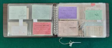
Ephemera, Album of Assorted Bacchus Marsh Ephemera. Album 1
... Album of Assorted Bacchus Marsh Ephemera. Album 1 ...This album of ephemera contains a variety items such as invitations, tickets, brochures and cards for businesses and shops in Bacchus Marsh and district. The items range in date from the 1890s through to the late twentieth century. Vinyl and plastic covered album housing small card and paper ephemera items in plastic sleeves and pockets.bacchus marsh history, ephemera bacchus marsh, bacchus marsh social history -
Federation University Historical Collection
Book, Telstra, Telstra Telephone Book for Ballarat, Horsham, Bacchus Marsh, Ararat, Stawell and Daylesford, 2019
... Telstra Telephone Book for Ballarat, Horsham, Bacchus Marsh ...Telstra Telephone books gave names, addresses and telephone numbers for telephone subscribers in areas. This telephone book is for the 053 region which includes Ballarat, HOrsham, Bacchus Marsh, Ararat, Stawell and Daylesford. Soft covered telephone directory with White Pages and Yellow Pages.directory, ballarat, hepburn, telstra, horsham, bacchus marsh, ararat, daylesford, telephone directory, white pages, yellow pages, phone directory -
Federation University Historical Collection
Book, Telstra, Telstra Telephone Book for Ballarat, Horsham, Bacchus Marsh, Ararat, Stawell and Daylesford, 2019
... Telstra Telephone Book for Ballarat, Horsham, Bacchus Marsh ...Telstra Telephone books gave names, addresses and telephone numbers for telephone subscribers in areas. This telephone book is for the 053 region which includes Ballarat, HOrsham, Bacchus Marsh, Ararat, Stawell and Daylesford. Soft covered telephone directory with White Pages and Yellow Pages. Ekizabeth Verlinden on the cover.directory, ballarat, hepburn, telstra, horsham, bacchus marsh, ararat, daylesford, telephone directory, white pages, yellow pages, phone directory -
 Federation University Historical Collection
Book, Telstra, Telstra Telephone Book for Ballarat, Horsham, Bacchus Marsh, Ararat, Stawell and Daylesford, 2021-2022
... Telstra Telephone Book for Ballarat, Horsham, Bacchus Marsh ...Telstra Telephone books gave names, addresses and telephone numbers for telephone subscribers in areas. This telephone book is for the 053 region which includes Ballarat, HOrsham, Bacchus Marsh, Ararat, Stawell and Daylesford. Soft covered telephone directory with White Pages and Yellow Pages. Boronia Florist on the cover.directory, ballarat, hepburn, telstra, horsham, bacchus marsh, ararat, daylesford, telephone directory, white pages, yellow pages, phone directory -
 Federation University Historical Collection
Book, Telstra, Telstra Telephone Book for Ballarat, Horsham, Bacchus Marsh, Ararat, Stawell and Daylesford, 2017-2018
... Telstra Telephone Book for Ballarat, Horsham, Bacchus Marsh ...Telstra Telephone books gave names, addresses and telephone numbers for telephone subscribers in areas. This telephone book is for the 053 region which includes Ballarat, HOrsham, Bacchus Marsh, Ararat, Stawell and Daylesford. Soft covered telephone directory with White Pages and Yellow Pages.directory, ballarat, hepburn, telstra, horsham, bacchus marsh, ararat, daylesford, telephone directory, white pages, yellow pages -
Federation University Historical Collection
Book, Telstra, Telstra Telephone Book for Ballarat, Horsham, Bacchus Marsh, Ararat, Stawell and Daylesford, 2008
... Telstra Telephone Book for Ballarat, Horsham, Bacchus Marsh ...Telstra Telephone books gave names, addresses and telephone numbers for telephone subscribers in areas. This telephone book is for the 053 region which includes Ballarat, HOrsham, Bacchus Marsh, Ararat, Stawell and Daylesford. Soft covered telephone directory with White Pages and Yellow Pages.directory, ballarat, hepburn, telstra, horsham, bacchus marsh, ararat, daylesford, telephone directory, white pages, yellow pages -
Federation University Historical Collection
Book, Telstra, Telstra Telephone Book for Ballarat, Horsham, Bacchus Marsh, Ararat, Stawell and Daylesford, 2015
... Telstra Telephone Book for Ballarat, Horsham, Bacchus Marsh ...Telstra Telephone books gave names, addresses and telephone numbers for telephone subscribers in areas. This telephone book is for the 053 region which includes Ballarat, HOrsham, Bacchus Marsh, Ararat, Stawell and Daylesford. Soft covered directory with White Pages and Yellow Pages. The cover features Federation University of Ballarat staffmember, Ellen Sabo, and two student mentors under the 'tree of Knowledge'.directory, ballarat, hepburn, telstra, horsham, bacchus marsh, ararat, daylesford, telephone directory, white pages, yellow pages, ellen sabo, student mentors, tree of knowledge, federation university, mt helen campus -
 Bacchus Marsh & District Historical Society
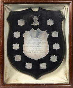
Trophy, E. G. Morris Shield, 1921
Edgar Gordon Morris was a prominent sportsman in Bacchus Marsh from around 1909 to 1918. He was regarded as the best all-round cricketer in the district and was also Secretary of the Bacchus Marsh Cricket Association. He was also a playing member of local football and tennis clubs. From about 1919 to 1921 Morris had been living in Swan Hill. His death at the age of 35 was reported in the Bacchus Marsh Express on the 5th March 1921 and was received with great sadness in sporting circles in Bacchus Marsh and district. To perpetuate his memory a shield to be presented to the premiership team each season in the Bacchus Marsh Cricket Association. The E.G. MOrris Shield was first presented for the 1921-1922 season.This item is of historical significance because it is associated with a particular person, Edgar Morris, a prominent sportsman and sports administrator in the Bacchus Marsh area. It is of comparative significance because it is representative of a shield design for a perpetual sporting trophy. The Shield also provides some research value by preserving and commemorating the memory of a prominent individual sports person in the Bacchus Marsh area.A silver plated shield created to perpetuate the memory of E. G. Morris. Enclosed inside a timber frame and sealed with a glass top. The shield is ringed by smaller shields with inscriptions identifying the premiership winning teams in the Bacchus Marsh Cricket Association between 1921 and 1930.The E. G. Morris Shield presented by G. H. Anderson to the Bacchus Marsh Cricket Association as a tribute to the memory of Edgar Gordon Morris 1921cricket bacchus marsh, bacchus marsh cricket association, edgar gordon morris cricketer -
 Bacchus Marsh & District Historical Society
Map, Lerderderg Gorge Road Goodmans Creek to Gisborne Road
... Shire of Bacchus Marsh ...The date of this map and its purpose has not been established. It was possibly produced to indicate landholders who were impacted by works along the Lerderderg Gorge Road. A single page paper map showing various blocks of land along the route of the Lerderderg Gorge Road near Bacchus Marsh from Goodmans Creek to the point where the road joins with Gisborne Road. The map is pasted into a bound volume containing 76 maps or plans in total. High resolution digital image stored on BMDHS computer network. bacchus marsh victoria maps, lerderderg gorge road bacchus marsh maps -
 Bacchus Marsh & District Historical Society
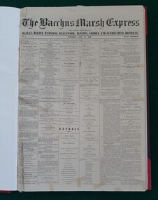
Newspaper, George Lane, Bacchus Marsh Express, July 1866
... Bacchus Marsh Express ...The Bacchus Marsh Express was a weekly newspaper first published in July 1866. It was produced in the Victorian town of Bacchus Marsh and was distributed in that township and the surrounding district. The original title was "The Bacchus Marsh Express : and General Advertiser for Ballan, Melton, Myrniong, Blackwood, Gisborne, Egerton and Gordon Districts". There were numerous variations to the name of this newspaper over the next 100 years but it usually retained the word 'Express' as part of its title. In September 2010 the word Express disappeared from the title and it became known as the Moorabool Weekly which then merged with some other newspapers over the next few years. For over 100 years the Crisp family owned or were associated with the production of the Express. By 22 February 1984 Syme Community Newspapers had taken over the Express. This entity was later renamed Fairfax Community Newspapers and continued to publish the Express until the disappearance of the name 'Express' altogether at the begining of September 2010. The last issue with the word 'Express' in the title being published on 31 August 2010.This is the first local Bacchus Marsh newspaper that continued to be published over a significant period of time. After beginning July 1866 it continued to be published weekly until the last issue on the 31 August 2010 was published. Nearly all published editions of the Express have been preserved. Issues No.1 and No.2, 7 and 14 July are not extant. The earliest known issue in existence is No.3, 21 July, 1866. Original copies from 21 July 1866 until 31 August 2010 are held by the Bacchus Marsh and District Historical Society.Bound and unbound newspaper issues, microfilm, and CD-ROM. printers, newspapers bacchus marsh, bacchus marsh express, christopher crisp 1844-1915, crisp family bacchus marsh -
 Bacchus Marsh & District Historical Society
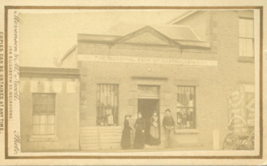
Photograph, Shop next to Royal Hotel Main Street Bacchus Marsh 1883
... Shop next to Royal Hotel Main Street Bacchus Marsh 1883 ...The building in this image was built by J. I. Murray for use as a Bank premises. The National Bank of Australasia opened a branch in the building in 1862 and remained there until 1865. The Colonial Bank of Australasia then occupied the building from 1865 until 1872. At the time this image was taken in 1883 the building was in use as a shop, although a sign saying 'National Bank of Australasia' could still be seen on the building. Goods for sale can clearly be seen in the windows and the photographers’ wagon or cart can be partly seen to the right of the picture. At a later stage the building became part of the Royal Hotel which can be seen to the right of the building. The small building to the left of the picture was used as a printing office by the West Bourke and South Grant Guardian newspaper between 1865 and 1872.Small sepia unframed photograph on card with gold border framing photograph. Housed in the album, 'Photographs of Bacchus Marsh and District in 1883 by Stevenson and McNicoll'. The image shows a shop in Main Street Bacchus Marsh in 1883. Goods for sale can be seen in the windows but there is no signage on the building to indicate what type of shop it is. A sign across the upper facade reads 'Colonial Bank of Australasia' but this bank had vacated this location by 1872. Three women and a man can be seen standing in front of the shop. Two of the women appear to be shaking hands. The woman standing in the doorway is wearing an apron and may be the shop owner or assistant. Just visible at the edge of the photo can be seen a buggy with advertisements on the back and side. Letters that can be distinguished suggest that in all probability this is the carriage used by Stevenson and McNicoll, Photographers, on their trips around rural towns and countryside. On the front: Stevenson & McNicoll. Photo. 108 Elizabeth St. Melbourne. COPIES CAN BE OBTAINED AT ANY TIME. On the back: LIGHT & TRUTH inscribed on a banner surmounted by a representation of the rising sun. Copies of this Portrait can be had at any time by sending the Name and Post Office Money Order or Stamps for the amount of order to STEVENSON & McNICOLL LATE BENSON & STEVENSON, Photographers. 108 Elizabeth Street, MELBOURNE. stevenson and mcnicoll 1883 photographs of bacchus marsh and district, shops bacchus marsh vic., banks bacchus marsh vic., commercial vehicles -
 Bacchus Marsh & District Historical Society
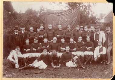
Photograph, Bacchus Marsh Football Club Premiers, 1912
... Bacchus Marsh Football Club Premiers ...This photo is one of the oldest known photographic records of an Australian Rules football team in the Bacchus Marsh area. Australian Rules football was played in this area as early as the 1870s. An organized competition to play regular matches was formed in the early years of the twentieth century. This photo records the premiership winning team of 1912 in the match played against Melton. The match was reported in the Bacchus Marsh Express of 31 August 1912. The names of the players are not recorded on this photo, but the Express records the names of Marsh, Fairbank, Northcott, Palmer, Roy Simpson, Morris, Tom Grant, Jack Taylor, Bert Jones, Portingale (c.), Densley Bros., Wittick, Harry Grant, Leonard, Odgers, Bodycote.This item has historic and social significance as an image of one of the early sporting teams of Bacchus Marsh and district. It is a typical example of team photographs of this era. It is evidence of the transition of football from a social informal setting to an organised activity and signals the growth of importance of sport, in this case Australian Rules football, as a cultural and social activity central to the Australian ethos.A sepia photograph print mounted on mounting board, showing a group of 27 men arranged in three rows in front of a banner reading PREMIERS 1912 BMFC. Eighteen men are in football guernseys, nine in civilian clothes, three of whom are carrying towels over their shoulders. One player, very likely the captain, is holding a football. The photo is taken in an outdoor setting. On the reverse in pencil: 'Middle row - 5th from left JOHN WITTICK.'bacchus marsh football club, australian rules football -
 Bacchus Marsh & District Historical Society
Map, Coimadai Parish Map, County of Bourke. Circa 1890s-1900s
... Shire of Bacchus Marsh ...The cadastral Parish of Coimadai, a subdivision of the County of Bourke, lies directly north of the township of Bacchus Marsh. The date of this map is uncertain. T.F. McGauran the person who made a photo-lithographic copy of the map was in charge of photo-lithography at the Victorian Department of Lands and Survey in the late 19th century until about 1910.A single page paper map showing the map for the Parish of Coimadai in the County of Bourke. A cadastral map showing parish boundaries and land ownership. A rectangle shaped area is missing from the centre of the map due to a tear or deliberate excision. The map is pasted into a bound volume containing 76 maps or plans in total. High resolution digital image stored on BMDHS computer network. Photo-lithographed at the Department of Lands and Survey, Melbourne by T.F. McGauran 26.8.[??] NOTE. Photo litho from L.P showing temporary surveys and occupation of land prepared for departmental use onlybacchus marsh region parish plans, coimadai parish maps, coimadai parish plan -
 Bacchus Marsh & District Historical Society
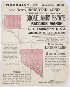
Map - Land Sales Plan, Broadlands Estate, Bacchus Marsh, 1916
... Broadlands Estate, Bacchus Marsh ...This land sales map was produced by real estate agents for an auction of part of a property near Bacchus Marsh known as the Broadlands Estate. 132 acres of irrigated land in 11 separate lots was to be auctioned on the 8th of June 1916. On the 27 May 1916, nine of the 11 eleven lots were withdrawn from sale. The reason stated was due to "road and severance difficulties", according to a notice in the Bacchus Marsh Express newspaper on 27 May, 1916, page.2. When the sale took place on 8th June the two lots were passed in but the local newspaper reported they were expected to be sold privately, see Express, 17 June, 1916, page. 2. The Broadlands Estate was owned by the Miller family whose father Henry Miller, 1809-1888, was a politician and an immensely wealthy financier in Victoria.A typical example of a land sale map of this era. The Broadlands Estate was just over 2,000 acres at its its peak size and was a significant holding of land in the Bacchus Marsh district. Paper printed land sales mapbroadlands estate bacchus marsh, land sales bacchus marsh, farms bacchus marsh, henry miller 1809-1888 -
![Map, Plan of Subdivision of Crown Portion 23 & parts 24-25, Parish of Korkuperrimul [1900s?]](/media/collectors/5e461d8021ea67224c82f2a1/items/675fe058304668462205d4fb/item-media/675fe0ef304668462205d7d6/item-fit-380x285.jpg) Bacchus Marsh & District Historical Society
Bacchus Marsh & District Historical SocietyMap, Plan of Subdivision of Crown Portion 23 & parts 24-25, Parish of Korkuperrimul [1900s?]
... Shire of Bacchus Marsh ...The Parish of Korkuperrimul includes a significant section of the township of Bacchus Marsh and extends in western and northern directions from the township area. The date of the subdivision indicated on this plan has not been established. The engineer's stamp on the drawing shows the firm of Muntz and Muntz who were operating under that name in the early part of the 20th century.A single page paper map showing 20 blocks of land for sale in the Parish of Korkuperrimul. Scale 100 feet to 1 inch. The map is pasted into a bound volume containing 76 maps or plans in total. High resolution digital image stored on BMDHS computer network. Stamped: 'Muntz & Muntz Civil Engineers, Architects & Surveyors, Trustees Chambers ?? Cor Collins Street and Bank Placeland sales bacchus marsh, bacchus marsh victoria maps, land sales korkuperrimul parish -
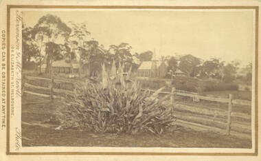 Bacchus Marsh & District Historical Society
Photograph, Agave Americana plant with view of Anglican and Presbyterian Churches in background, Bacchus Marsh 1883
... Presbyterian Churches in background, Bacchus Marsh 1883 ...This image appears to have been created to depict this good size Agave Americana plant, also known as the 'Century Plant'. Agaves are an introduced species to Australia. Their local propagation in Victoria is mentioned in Victorian newspapers as early as the 1850s. By the 1870s they appear to have become fairly common but still relatively novel. The side by side view of the Holy Trinity Anglican and Saint Andrews Presbyterian Churches forms an interesting frame for this botanical study. On the far right of the image in the background can be seen the Presbyterian Church Manse built in 1858 and demolished in the 20th century.Small sepia 'carte de viste' style unframed photograph on card with gold border framing photograph. Housed in the Jeremeas Family Album which contains photographs of Bacchus Marsh and District in 1883 by the photographers Stevenson and McNicoll. In the foreground of this image is an Agave Americana plant growing alongside a post and rail fence. In the background can be seen the Anglican Holy Trinity Church on the left and Saint Andrews Presbyterian Church on the right.Printed On the front: Stevenson & McNicoll. Photo. 108 Elizabeth St. Melbourne. COPIES CAN BE OBTAINED AT ANY TIME. On the back: LIGHT & TRUTH inscribed on a banner surmounted by a representation of the rising sun. Copies of this Portrait can be had at any time by sending the Name and Post Office Money Order or Stamps for the amount of order to STEVENSON & McNICOLL LATE BENSON & STEVENSON, Photographers. 108 Elizabeth Street, MELBOURNE. stevenson and mcnicoll 1883 photographs of bacchus marsh and district, churches bacchus marsh, holy trinity anglican church bacchus marsh, holy trinity church of england bacchus marsh, saint andrews presbyterian church bacchus marsh, plants, agaves, exotic plants, agave americana -
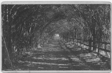 Bacchus Marsh & District Historical Society
Photograph, Osage Orange Avenue Taverner Street Bacchus Marsh
... Osage Orange Avenue Taverner Street Bacchus Marsh ...A.C. (Arthur Charles) Simon a pioneer orchardist in the Bacchus Marsh district planted this avenue of Osage orange trees in about 1883, creating an imposing entrance to his property from Taverner Street. Simon also believed that the trees on his orchard property would provide a protective shelter for his other plants. Osage orange trees (Maclura pomifera) are a small deciduous tree or large shrub, native to the south-central United States. It usually grows to about 8 to 15 metres high. The distinctive fruit, a multiple fruit that resembles an immature orange, is roughly spherical in shape, about 8 to 15 centimetres in diameter, and turns bright yellow-green in the autumn. A. C. Simon is believed to have imported the Osage orange seeds from America around the 1860s and later used them to plant the trees depicted in this image. The date of this image is not certain but it probably shows the trees around the 1900s or 1910s. The avenue of trees was known for many years in Bacchus Mars as 'Simons Avenue', and were featured in a Rose series postcard dating from around 1900-1920. The remnants of this avenue or grove of trees can be seen on some of the properties on the north side of Taverner Street Bacchus Marsh and along the Werribee River west of the FIsken Street bridge.The Bacchus Marsh Heritage Study of 1995 described the Osage Orange Tree avenue as being of regional historical significance as a landscaping practice, pioneering of its type, It was also described as of local significance as a well-known landmark due to it be being represented on widely distributed post cards which depicted scenes of Bacchus Marsh in the early part of the twentieth century. This early photographic image is evidence of this social and cultural significance.A black and white photograph print mounted on mounting board showing an avenue of Osage orange trees. trees, osage orange trees, simon family bacchus marsh, arthur charles simon 1833-1924, orchardists -
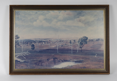 Bacchus Marsh & District Historical Society
Painting, View of Bacchus Marsh from Stamford Hill circa 1880s
... View of Bacchus Marsh from Stamford Hill circa 1880s ...The date of the scene depicted in this painting has not been identified. The painting has no artist signature or date. The view depicted is from an area close to the present day Madden Drive in Bacchus Marsh. The angle of the view suggests the artists viewpoint may have been from a spot close to the intersection of Madden Drive and Muir Street looking east over the town. Several buildings constructed in the 1860s and 1870s can be seen in the painting. These include Saint Andrews Presbyterian Church (now Uniting Church), built 1865, Stone Villa in Bennett Street, the Bacchus Marsh Court House, the former National Bank and the Border Inn, all on Main Street, and in the distance Saint Bernard’s Catholic Church. Buildings such as Simon’s Garage erected in 1913, on the corner of Main Street and Grant Street are not shown. In the foreground running horizontally Grant Street can be seen. The view of Grant Street shows very few buildings. One house in the centre of the picture is Murdoch's Cottage. A brick house constructed in 1868 on the corner of Grant Street and Waddell Street. To the right of the picture along Grant Street no buildings are shown. The store built by John Jory in 1890 at 60-62 Grant Street which survives as a building in 2025 is not shown. Some allowance for artistic interpretation must be allowed but based on what the scene depicts it suggests a scene of Bacchus Marsh in the late 1870s or 1880s. Print reproduction of an oil painting. Framed. Undated. Unsigned. BMDHS Location: AR/B12/Beside (on floor)views bacchus marsh vic., paintings bacchus marsh vic., landscapes bacchus marsh vic. -
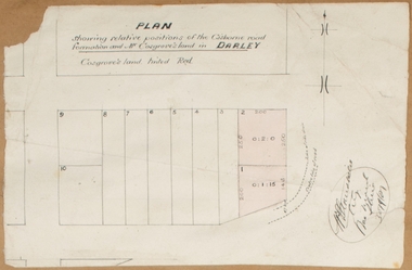 Bacchus Marsh & District Historical Society
Map, Plan showing relative positions of the Gisborne road formation and Mr. Cosgrove's land in Darley. 1907
... Shire of Bacchus Marsh ...No background information about the roadworks referred to in this plan has been found. The portion of land referred to as 'Cosgroves' in this plan is located close to the present day Darley Park Recreation Park in Darley, near Bacchus Marsh. The land indicated appears to be close to the corner of Grey Street and Gisborne Road. James Cosgrove who died in 1923 aged 65 owned a farm of 52 acres in this area of Darley.Single page map showing a proposed deviation of the Gisborne road in Darley and its position relative to land owned by Mr. Cosgrove. The land owned by Cosgrove is shaded in pink. No scale indicated. Part of a set of maps which are pasted into a bound volume containing 76 maps or plans in total. High resolution digital image stored on BMDHS computer network. Signature (illegible), Eng, Bac Marsh Shire, 30/9/07bacchus marsh roads and streets, darley victoria maps -
 Bacchus Marsh & District Historical Society
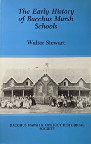
Book, The Early History of Bacchus Marsh Schools, 1983
... The Early History of Bacchus Marsh Schools ...An account of the origins and development of public and private schools in the Bacchus Marsh district. The period examined stretches from the late 1840s through until 1920. This comprises almost 20 schools some of which have long faded from memory. Others such as the Bacchus Marsh Primary School and Saint Bernard's Catholic School continue to this day. Citation: The Early History of Bacchus Marsh Schools by Walter Stewart. Published by Bacchus Marsh and District Historical Society, Bacchus Marsh, Vic., 1983.A printed book published in hardback and paper editions. 178 pages, with index, and black and white photographs. BMDHS Location: AR/SU4non-fictionAn account of the origins and development of public and private schools in the Bacchus Marsh district. The period examined stretches from the late 1840s through until 1920. This comprises almost 20 schools some of which have long faded from memory. Others such as the Bacchus Marsh Primary School and Saint Bernard's Catholic School continue to this day. Citation: The Early History of Bacchus Marsh Schools by Walter Stewart. Published by Bacchus Marsh and District Historical Society, Bacchus Marsh, Vic., 1983.schools bacchus marsh, bacchus marsh primary school, bmdhs publication -
 Bacchus Marsh & District Historical Society
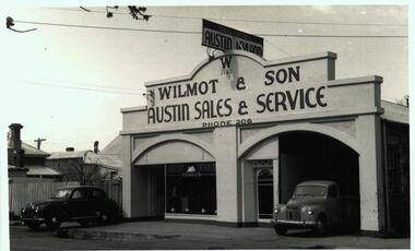
Photograph, Wilmot and Son Austin Sales and Service Main Street Bacchus Marsh
... Wilmot and Son Austin Sales and Service Main Street Bacchus ...This building, located at 97 Main Street Bacchus Marsh, was built by Mr George Muir in 1920 using bluestone walls from Landsberg House, a former boarding school at Mt. Blackwood. In 1946 Mr W. J. Wilmot opened a car sales business which was sold in 1954 to trade as Stamford Motors. Subsequently, various businesses operated on this site, and is still in use, presently as an accountancy business.Black and white photographic print. Photograph dates from the 1940s and shows a bluestone building with lintels of local sandstone supporting a pediment with a sign advertising Austin cars fixed on top. Signage on the pediment reads: W 1930 WILMOT & SON AUSTIN SALES & SERVICE PHONE 206. The frontage is divided in two, both sections topped by an arch. The left-hand section is glass-fronted, the right section open for vehicle access. The door between the two sections is also arched. Two vehicles are parked at the front, a sedan and a ute, presumably both Austins. The bluestone building materials are visible at the side.shops bacchus marsh vic., main street bacchus marsh vic., garages, landsberg house, w j wilmot -
 Bacchus Marsh & District Historical Society
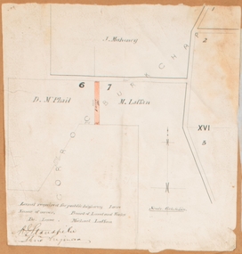
Map, Land required for a public highway near Rowsley, Victoria. Circa 1880s
... Shire of Bacchus Marsh ...This map indicates portions of land in the Parish of Gorrockburkchap near Rowsley which was required for construction of a road. The land required was leased to a Michael Laffan. Other blocks of land nearby owned or leased by D. McPhail and J. Mahoney are also indicated on the map. The date of the map is not known. However newspaper reports in the Bacchus Marsh Express on the 18 March 1882, page 3, column 3 mention land occupied by McPhail and Laffan near Rowsley in connection to the construction of a public road.Single page map showing land occupied by farmers D. McPhail and Michael Laffan which was required for a public highway. Scale 6 chains to inch. Part of a set of maps which are pasted into a bound volume containing 76 maps or plans in total. High resolution digital image stored on BMDHS computer network. Signed by Shire Engineer, W.E. Standfieldrowsley victoria maps -
 Bacchus Marsh & District Historical Society
Map, Village allotments, Parish of Myrniong, County of Bourke
... Shire of Bacchus Marsh ...Myrniong is a village 9 kilometers west of Bacchus Marsh. Prior to 1863 the area was known as Blow's Flat. This map which was produced in 1903 and according to the catalogue record of this map held at the State Library of Victoria was based on an earlier map created in 1861. The early layout of streets for the village of Myrniong can be seen on this map. The streets shown are, Main Street, Hardy Street, Blow Street, Myrniong Street, Shuter Street, and Blackwood Street. An area marked as a reserve for a school can be seen between Hardy Street and Main Street.A single page paper map. A cadastral parish map of Myrniong in Victoria, showing numbered land allotments. Photo-lithographed at the Department of Lands & Survey, Melbourne, in 1903. Based on an original map created in 1861. The map is pasted into a bound volume containing 76 maps or plans in total. High resolution digital image stored on BMDHS computer network. Surveyed by John Hardy, Surveyor ; photo-lithographed at the Department of Lands & Survey, Melbourne by T.F. McGauran, 24.12.03myrniong parish plan, myrniong parish maps -
 Bacchus Marsh & District Historical Society
Map, Allotments in the Village of Rowsley, Parish of Gorrocburkghap, County of Grant c.1856
... Shire of Bacchus Marsh ...Rowsley is a locality 11 kilometers south-west of Bacchus Marsh. The date of this map is uncertain. A very similar map held by the State Library of Victoria (SLV) contains slightly more information than this copy and is dated as an 1856 map. SLV reference: 'Allotments in the Village of Rowsley, Parish of Gorrocburkghap, County of Grant', by T. Nixon, Assistant Surveyor, May 1856 ; Surveyor General’s Office, July 18 1856 (lithographed by R. Meikle). (1856). Melbourne: Surveyor General’s Office. MAPS 820 BJE 1837- ROWSLEY 1856. A single page paper map. A cadastral map of the Village of Rowsley in Victoria, showing numbered land allotments. 57 allotments are shown on the map and some areas set aside as reserves. Allotments 8, and 10-16 are outlined in red ink and allotment 9 has a cross in red ink on it. The map is pasted into a bound volume containing 76 maps or plans in total. High resolution digital image stored on BMDHS computer network. rowsley victoria history, rowsley victoria maps -
 Bacchus Marsh & District Historical Society
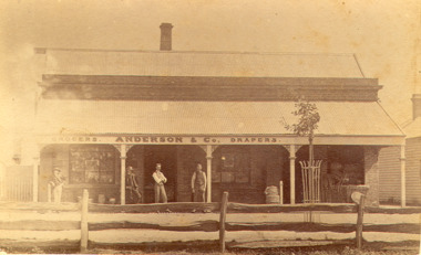
Photograph, Anderson's Store, Main Street, Bacchus Marsh circa 1870s-1890s
... Anderson's Store, Main Street, Bacchus Marsh circa 1870s ...This store in Main Street Bacchus Marsh was first opened by James Young in November 1866. In October 1869 it was purchased by William Anderson and was operated by members of the Anderson family until 1971. The site of the store was on the southern side of Main Street on the eastern side of Eddie Toole Park. On the opposite side of the street was the site of the former Post Office on the northern side of Main Street. The store was first named the Border Mills Store during James Young's ownership and was later known as the Border Store (Anderson & Co.).Small black and white photograph showing Anderson’s store. It shows a large stone building with a corrugated iron verandah which bears a painted sign of the name of the business: GROCERS. ANDERSON & Co. DRAPERS. Behind a brick parapet rises a hip roof with one chimney visible. Four men stand in casual poses ranged along the verandah. A post and rail fence runs along the road frontage. A tree is planted in an ornamental wrought iron plant protector on the inside of the fence.On the back in decorative print: “ New York Photographic Adelaide Travelling Brand Chas. F. Husband Manager.” In handwriting: Border store built by James Young 1866 owned by Anderson 1869-1972. BMDHS stamp and no. HS 411.shops bacchus marsh vic., anderson's store bacchus marsh, stevenson and mcnicoll 1883 photographs of bacchus marsh and district -
 Bacchus Marsh & District Historical Society
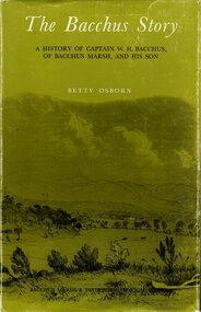
Book, The Bacchus Story: A History of Captain W. H. Bacchus of Bacchus Marsh and His Son, 1973
... The Bacchus Story: A History of Captain W. H. Bacchus of ...William Bacchus was one of the first European colonists to live in the township which was later named after him. He arrived in land occupied by the Wurundjeri and Wadawurrung peoples in 1838 and established a large sheep farm. He died in 1849 and his son Henry Bacchus continued his farming interests in the district until his death in 1887. This work is a biographical portrait of William and Henry Bacchus and of the early European occupation in the Bacchus Marsh district. PUBLICATION DETAILS: Bacchus Marsh, Vic., Bacchus Marsh and District Historical Society Inc., 1973:118 pages, 23 cm.non-fictionWilliam Bacchus was one of the first European colonists to live in the township which was later named after him. He arrived in land occupied by the Wurundjeri and Wadawurrung peoples in 1838 and established a large sheep farm. He died in 1849 and his son Henry Bacchus continued his farming interests in the district until his death in 1887. This work is a biographical portrait of William and Henry Bacchus and of the early European occupation in the Bacchus Marsh district. PUBLICATION DETAILS: Bacchus Marsh, Vic., Bacchus Marsh and District Historical Society Inc., 1973: william bacchus, bacchus family, henry bacchus, bacchus marsh, bmdhs publication