Showing 202 items
matching demolition site
-
 Whitehorse Historical Society Inc.
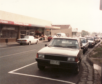
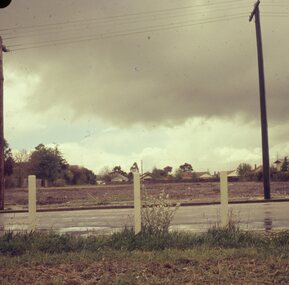
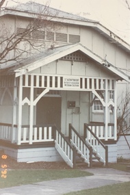
Photograph, Britannia Street, Mitcham, 13/06/1986 12:00:00 AM
2 Coloured photos of Brittania Street, Mitcham. Looking North from Corner of Whitehorse Road. Shops on Western side of Britannia Street are located on the site of Barelli's shop, dwelling and bakehouse. To the north of these buildings and across a cobblestone lane now called Enterprise Way was the Salvation Army Citadel, .a further commercial building housing a printer. Erection of this building necessitated demolition of Barelli's stable and reclamation of its horseyard. The Salvation Army are now located on the Mitcham Road and Harrison Street corner.britannia street mitcham -
 Ballarat Heritage Services
Photograph, Fernleigh Flats, Ballarat, 12/02/2022
Residents of the Fernleigh Flats Retirement village are understood to be well and strong enough to care for themselves and need to be over the age of 55 years. Fernleigh Flats is owned and operated by the Seventh Day Adventist Church. "TO LET, a Brick House, corner of Urquhart and Ripon Streets. Apply Owen Cazaly, Mining Exchange."(Ballarat Star, 16 Aug 1867) "SALE BY AUCTION, Corner of Urquhart and Ripon streets, 07 COMFORTABLE COTTAGE PROPERTY. M'GREGOR BROTHERS, instructed by the owner, Mr Bradbury, who has bought another property, will sell by public auction, on Monday, 16th May, at half-past 12, His six-roomed substantially-built RESIDENCE. The owner has, under his own supervision, spared no expense in making this a most comfortable and convenient dwelling, situated on a quarter of an acre allotment, at the corner of Urqhuart and Ripon streets, high and dry. Garden laid out with choice young fruit trees; ground capable of growing anything. Fowl yard fenced off. making It a most desirable residence. For a family residence or as An investment this is a good opportunity. Inspection invited. Auctioneer, R. M'GREGOR. (Ballarat Star, 12 May 1893.)A retirement village on the corner of Urquhart Street and Ripon Street, Ballarat. The street trees surrounding this property include a number of trees (blue cedar?) and suggest the demolition of an older stately home on this site. fernleigh flats, residences, architecture -
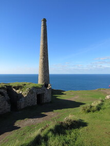
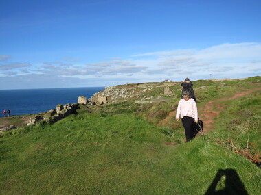
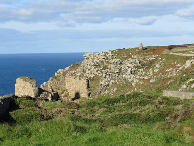
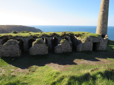
 Ballarat Heritage Services
Photograph - Colour, Dorothy Wickham, St Just, Cronwall, World Heritage Site
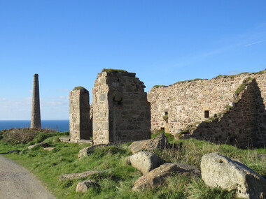
A stone’s throw from Land’s End, this is the most westerly Area of the Site. St Just is characterised by big skies, jagged rocks, stark moorland, and iconic clifftop engine houses perched above the Atlantic in some incredible locations. No wonder this dramatic setting has inspired generations of artists, writers and photographers. World-famous for their mineralogy, the mining sites here are extremely well preserved – as is the sense of community amongst the people whose lives they once dominated. This Area’s unique geography and mineralogy meant that undersea mining was more concentrated here than anywhere else in the world in the 18th and 19th centuries. The oldest surviving Cornish beam engine (constructed in 1840) remains in its original engine house at Levant, restored and still working under steam. Geevor, one of the last mines to close in Cornwall (1990), was saved from demolition and is now the largest metalliferous mine site open to the public in the UK. The historic mining town of St Just is home to characteristic rows of granite mine workers’ cottages, public squares, shops, cafés, art galleries and, just off Bank Square, a medieval grassed amphitheatre – the Plen an Gwary or ‘playing place’.st just, world heritage, ellis, penrose, cornwall, mining, mines -
 Ballarat Heritage Services
Photograph - Colour, Dorothy Wickham, St Just, Cornwall, World Heritage Site
A stone’s throw from Land’s End, this is the most westerly Area of the Site. St Just is characterised by big skies, jagged rocks, stark moorland, and iconic clifftop engine houses perched above the Atlantic in some incredible locations. No wonder this dramatic setting has inspired generations of artists, writers and photographers. World-famous for their mineralogy, the mining sites here are extremely well preserved – as is the sense of community amongst the people whose lives they once dominated. This Area’s unique geography and mineralogy meant that undersea mining was more concentrated here than anywhere else in the world in the 18th and 19th centuries. The oldest surviving Cornish beam engine (constructed in 1840) remains in its original engine house at Levant, restored and still working under steam. Geevor, one of the last mines to close in Cornwall (1990), was saved from demolition and is now the largest metalliferous mine site open to the public in the UK. The historic mining town of St Just is home to characteristic rows of granite mine workers’ cottages, public squares, shops, cafés, art galleries and, just off Bank Square, a medieval grassed amphitheatre – the Plen an Gwary or ‘playing place’.st just, world heritage,, ellis,, penrose, cornwall, mining, mines -
 Ballarat Heritage Services
Photograph - Colour, Dorothy Wickham, St Just, Cornwall, World Heritage Site
A stone’s throw from Land’s End, this is the most westerly Area of the Site. St Just is characterised by big skies, jagged rocks, stark moorland, and iconic clifftop engine houses perched above the Atlantic in some incredible locations. No wonder this dramatic setting has inspired generations of artists, writers and photographers. World-famous for their mineralogy, the mining sites here are extremely well preserved – as is the sense of community amongst the people whose lives they once dominated. This Area’s unique geography and mineralogy meant that undersea mining was more concentrated here than anywhere else in the world in the 18th and 19th centuries. The oldest surviving Cornish beam engine (constructed in 1840) remains in its original engine house at Levant, restored and still working under steam. Geevor, one of the last mines to close in Cornwall (1990), was saved from demolition and is now the largest metalliferous mine site open to the public in the UK. The historic mining town of St Just is home to characteristic rows of granite mine workers’ cottages, public squares, shops, cafés, art galleries and, just off Bank Square, a medieval grassed amphitheatre – the Plen an Gwary or ‘playing place’.st just, world heritage, ellis, penrose, cornwall, mining, mines -
 Ballarat Heritage Services
Photograph - Colour, Dorothy Wickham, St Just, Cronwall, World Heritage Site
A stone’s throw from Land’s End, this is the most westerly Area of the Site. St Just is characterised by big skies, jagged rocks, stark moorland, and iconic clifftop engine houses perched above the Atlantic in some incredible locations. No wonder this dramatic setting has inspired generations of artists, writers and photographers. World-famous for their mineralogy, the mining sites here are extremely well preserved – as is the sense of community amongst the people whose lives they once dominated. This Area’s unique geography and mineralogy meant that undersea mining was more concentrated here than anywhere else in the world in the 18th and 19th centuries. The oldest surviving Cornish beam engine (constructed in 1840) remains in its original engine house at Levant, restored and still working under steam. Geevor, one of the last mines to close in Cornwall (1990), was saved from demolition and is now the largest metalliferous mine site open to the public in the UK. The historic mining town of St Just is home to characteristic rows of granite mine workers’ cottages, public squares, shops, cafés, art galleries and, just off Bank Square, a medieval grassed amphitheatre – the Plen an Gwary or ‘playing place’.st just, world heritage, ellis, penrose, cornwall, mining, mines -
 Ballarat Heritage Services
Photograph - Colour, Dorothy Wickham, St Just, Cornwall, World Heritage Site
A stone’s throw from Land’s End, this is the most westerly Area of the Site. St Just is characterised by big skies, jagged rocks, stark moorland, and iconic clifftop engine houses perched above the Atlantic in some incredible locations. No wonder this dramatic setting has inspired generations of artists, writers and photographers. World-famous for their mineralogy, the mining sites here are extremely well preserved – as is the sense of community amongst the people whose lives they once dominated. This Area’s unique geography and mineralogy meant that undersea mining was more concentrated here than anywhere else in the world in the 18th and 19th centuries. The oldest surviving Cornish beam engine (constructed in 1840) remains in its original engine house at Levant, restored and still working under steam. Geevor, one of the last mines to close in Cornwall (1990), was saved from demolition and is now the largest metalliferous mine site open to the public in the UK. The historic mining town of St Just is home to characteristic rows of granite mine workers’ cottages, public squares, shops, cafés, art galleries and, just off Bank Square, a medieval grassed amphitheatre – the Plen an Gwary or ‘playing place’.st just, world heritage, ellis, penrose, cornwall, mining, mines -
 Ballarat Heritage Services
Photograph - Colour, Dorothy Wickham, St Just, Cornwall, World Heritage Site
A stone’s throw from Land’s End, this is the most westerly Area of the Site. St Just is characterised by big skies, jagged rocks, stark moorland, and iconic clifftop engine houses perched above the Atlantic in some incredible locations. No wonder this dramatic setting has inspired generations of artists, writers and photographers. World-famous for their mineralogy, the mining sites here are extremely well preserved – as is the sense of community amongst the people whose lives they once dominated. This Area’s unique geography and mineralogy meant that undersea mining was more concentrated here than anywhere else in the world in the 18th and 19th centuries. The oldest surviving Cornish beam engine (constructed in 1840) remains in its original engine house at Levant, restored and still working under steam. Geevor, one of the last mines to close in Cornwall (1990), was saved from demolition and is now the largest metalliferous mine site open to the public in the UK. The historic mining town of St Just is home to characteristic rows of granite mine workers’ cottages, public squares, shops, cafés, art galleries and, just off Bank Square, a medieval grassed amphitheatre – the Plen an Gwary or ‘playing place’.st just, world heritage, ellis, penrose, cornwall, mining, mines -
 Ballarat Tramway Museum
Slide - 27 mm sq slide/s - set of 4, Lilian Butler, SEC Wendouree Parade depot site, Jul. 1973
Yields information about some of the SEC Wendouree Parade depot after it had been demolished.Set of four Colour 27 x 27 mm slides in plain white cardboard mounts of four views of the SEC Wendouree Parade depot site with the buildings demolished and the site cleared. The second slide shows the Trackwork still in position in the roadway and the last the view from Gregory St. Slide not dated - building demolition works commenced July 1972. Photo from the collection of Lilian Butler.ballarat, tramways, trams, sec depot, demolition, depot, wendouree parade -
 Ballarat Tramway Museum
Newspaper, The Courier Ballarat, No headline - but depot Tram Lines ripped up, 13/02/1973 12:00:00 AM
Yields information about the demolition or removal of the track in Wendouree Parade and how it was done.Newspaper clipping from The Courier, 13/2/1973- photo of tram lines being ripped up in Wendouree Parade at what would appear to be the site of Depot Loop, though possibly at the junction for the SEC depot. Has a point casting in the foreground and the church on the corner of Forest St. in the background. Has arm of excavator and a worker crossing the ripped up track as well. On top has a caption small note about the work and reference to Lydiard St. works.date in pencil of "13/2/73" in top right hand corner of cutting.trams, tramways, wendouree parade, track removal, sec depot, depot loop -
 Bendigo Historical Society Inc.
Photograph - Forest Street
Colour photograph showing the demolition work near the corner of Forest and High Street. Red bricks building around the excavation site. An excavator can be seen in the foreground and a man is crouching looking at something on the ground. On the back in pencil Forest street demolition ? 2011forest street, demolition -
 Kew Historical Society Inc
Archive (Sub-series) - Subject File, Community Centre (Kew), 1958
Various partiesReference, Research, InformationSecondary Values (KHS Imposed Order)Subject file containing correspondence between office-bearers of the Kew Historical Society and the City of Kew relating to the possibility of purchasing historic buildings from demolition and for use as a community centre and historical society premises or museum. Properties discussed included 14/16 Princess Street and the hall (Neama) on the site of St Paul’s School.community centres -- kew (vic), historical museums - proposedcommunity centres -- kew (vic), historical museums - proposed -
Kew Historical Society Inc
Archive (Sub-series) - Subject File, Congregational Church (Walpole Street, Kew), 1958
Various partiesReference, Research, InformationSecondary Values (KHS Imposed Order)Subject file containing information about the Congregational Church in Walpole Street, Kew (demolished 1979). The file contains numerous original and copied primary sources as well as short histories and correspondence between the Kew Historical Society and the Historic Buildings Preservation Council when it was proposed to demolish the church. Following the demolition of the Church, an aged care facility - Bodalla - was erected (since demolished). The file contains some information on Bodalla and a foundation stone relating to the former Church which was placed on the site. In the file, there is a photocopy of a brass plaque from 1860 that refers to the architect being George Wharton and the builders Messrs. Leach & Bicknell. congregational church -- kew (vic), churches -- kew (vic), walpole street -- kew (vic.)congregational church -- kew (vic), churches -- kew (vic), walpole street -- kew (vic.) -
 Kew Historical Society Inc
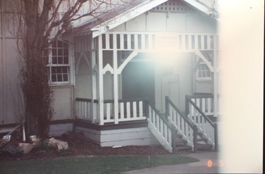
Photograph - 1st Kew Scout Hall, Disraeli Street, 1992
The 1st Kew Scouts was one of the first Scout Troops in Victoria, being formed in 1909. From 1927 they met in a magnificent Scout Hall in Disraeli Street, Kew until it was demolished in 1993. Still operating (in 2020) from their new Scout Hall on the corner of Kilby Road and Kellett Grove, Kew.Original colour positive photograph of the 1st Kew Scout Troop's single-storey wooden hall in Disraeli Street, Kew, prior to the building's demolition and the relocation of the troop to a new site."1st Kew Scout Hall"scout troops -- kew (vic.), 1st kew scouts, scout halls -- kew (vic.), scout halls -- melbourne (vic.), boy scouts -
 Kew Historical Society Inc
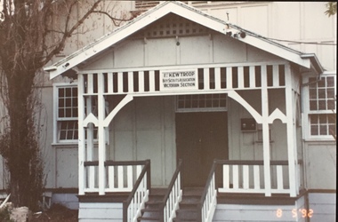
Photograph - 1st Kew Scout Hall, Disraeli Street, 1992
The 1st Kew Scouts was one of the first Scout Troops in Victoria, being formed in 1909. From 1927 they met in a magnificent Scout Hall in Disraeli Street, Kew until it was demolished in 1993. Still operating (in 2020) from their new Scout Hall on the corner of Kilby Road and Kellett Grove, Kew.Original colour positive photograph of the 1st Kew Scout Troop's single-storey wooden hall in Disraeli Street, Kew, prior to the building's demolition and the relocation of the troop to a new site."1st Kew Scout Hall / Cr Disraeli and Childers St North Kew. Demolished ... Re-established Cr Kilby Rd & Kellett Grove. Nth Kew .."scout troops -- kew (vic.), 1st kew scouts, scout halls -- kew (vic.), scout halls -- melbourne (vic.), boy scouts -
 Kew Historical Society Inc
Photograph - 1st Kew Scout Hall, Disraeli Street, 1992
The 1st Kew Scouts was one of the first Scout Troops in Victoria, being formed in 1909. From 1927 they met in a magnificent Scout Hall in Disraeli Street, Kew until it was demolished in 1993. Still operating (in 2020) from their new Scout Hall on the corner of Kilby Road and Kellett Grove, Kew.Original colour positive photograph of the 1st Kew Scout Troop's single-storey wooden hall in Disraeli Street, Kew, prior to the building's demolition and the relocation of the troop to a new site."1st Kew Scout Hall / Cr Disraeli and Childers St North Kew. Demolished ... Re-established Cr Kilby Rd & Kellett Grove. Nth Kew .."scout troops -- kew (vic.), 1st kew scouts, scout halls -- kew (vic.), scout halls -- melbourne (vic.), boy scouts -
 Queen Victoria Women's Centre
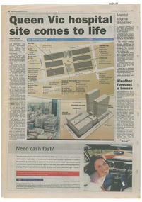
Newspaper excerpt, Queen Vic hospital site comes to life, 24 August 2003
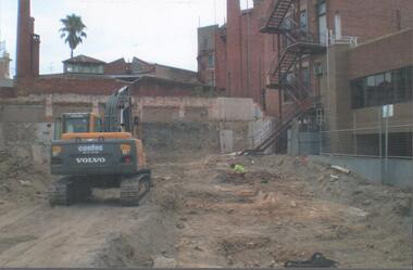
newspaper articles Sunday Herald Sun page 28. colour photograph of the construction works bottom left of article's images. Graphic images of the the construction works and what would be included in the centre.town planning, historic building, retail trade, restaurants, construction and demolition workers -
 Sunbury Family History and Heritage Society Inc.
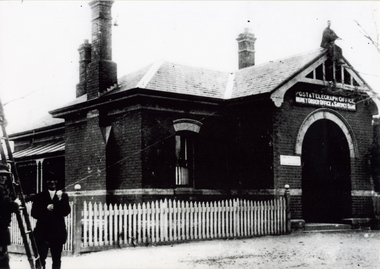
Photograph, c 1900s
The building is the Sunbury Post and Telegraph Office and residence, which was built on the corner of Brook and Evans Street in 1892. Prior to that time the postal service ion Sunbury was conducted at the railway station. Over the years changes and extensions have taken place to the building to accommodate it for modern postal delivery practices although it still operates from the same site.The Sunbury Post Office has operated in a building on the same site since 1892 despite many changes and extensions made to the building, which included the demolition of the residence attached to the original building.A black and white photograph of Victorian style brick building with a slate roof with 3 chimneys and surrounded by a white picket fence. Two men are standing by a ladder on the LHS of the image. sunbury, sunbury post office, post and telegraph offices -
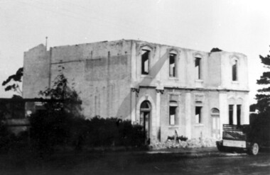
 Surrey Hills Historical Society Collection
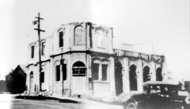
Photograph, Demolition of Tower House Day and Boarding School, Surrey Hills in 1932 (1)
This building dated back to the 1880s and had previously operated as Delany's Hotel and then the Royal Hotel. It was built near the site of the original Delany's Hotel, built in 1856. The Royal Hotel closed in 1921 after the area voted to be a 'dry area' in the local option poll. Tower House Day and Boarding School operated from 1921 until 1932. Norman Carter took many photos of Surrey Hills and Mont Albert from the 1920s; many were associated with events and activities of the Church of England.Black and white photo of a partially demolished building. The roof and part of the second storey are missing. What remains indicates that it has been a large building in the Victorian style. Along one side at ground level there are 4 arches, perhaps entry to a covered veranda, above which is a colonnade, and perhaps an open veranda on the upper level. There is a mixture of treatments to the surrounds of the windows. On the corner, within an arch which may have once been a doorway, is a sign reading: "TOWER HOUSE / DAY / & / BOARDING SCHOOL". There is a car with a retractable hood in the lower RH Corner of the photo.Rear top centre in blue biro "1932" (crossed out); top RH corner "498" in red biro; centre "Demolition of / Tower House Day & Boarding / cr Canterbury & Broughton Rds / previously Tower House Hotel / originally Royal Hotel / See partner photo."; bottom RH cnr "demol (in red biro) / 20-8-32". All in Jocelyn Hall's handwriting.tower house day and boarding school, schools, education, royal hotel, hotels, construction and demolition, dry area, licensing polls, temperance movement, delany's hotel, norman carter -
 Surrey Hills Historical Society Collection
Photograph, Demolition of Tower House Day and Boarding School, Surrey Hills in 1932 (2), 20/08/1932
This building dated back to the 1880s and had previously operated as Delany's Hotel and then the Royal Hotel. It was built near the site of the original Delany's Hotel, built in 1856. The Royal Hotel closed in 1921 after the area voted to be a 'dry area'. Tower House Day and Boarding School operated from 1921 until 1932. Norman Carter took many photos of Surrey Hills and Mont Albert from the 1920s; many were associated with events and activities of the Church of England.Black and white photo of a partially demolished building. The roof is missing and there is a pile of rubble along the front wall. What remains indicates that it has been a large building in the Victorian style. There is a mixture of treatments to the surrounds of the windows. On the RHS part of a truck can be seen.Original: Top LH corner in blue biro "see matching photo"; top RH corner "498 / spare"; bottom LH corner in lead pencil "N Carter"; bottom RH corner in blue biro "20-8-32" - all Jocelyn Hall's handwriting.tower house day and boarding school, schools, education, royal hotel, hotels, construction and demolition, dry area, licensing polls, temperance movement, delany's hotel, norman carter -
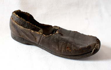 Brighton Historical Society
Shoe, Child's shoe, 19th century
This child's shoe was found underneath the floorboards of the historic Brighton house St Ninian's, 10 Miller Street, during its demolition in September 1974. One of Brighton's earliest buildings, St Ninian's was built around 1841 for merchant, politician and former British naval officer George Ward Cole (1783-1879) and his family. Ward Cole was a prominent member of Victorian society in the mid-to-late nineteenth century. He served in the Victorian Parliament from 1853-55 and 1859-79. His seaside home in Brighton was a fashionable rendezvous for many important identities who shaped Melbourne’s history. Victoria’s first royal visitor, Prince Alfred, Duke of Edinburgh, was a guest there in 1867. It is possible the shoe belonged to one of the Ward Cole children. During the demolition of St Ninian's in September 1974 the Brighton Historical Society's then-secretary, Rosalind Landells, snuck onto the work site in the hope of saving some part of the building and its history. She found this shoe under the partially-demolished floor of the house.Brown leather child's shoe with an ankle strap, fastening with a mother-of-pearl button. Heavily deteriorated.Handwritten in pencil on the sole of the shoe: "Found under floor at St Ninians 1974 Sept during demolition".st ninians, george ward cole, children's clothing, 19th century -
 Vision Australia
Photograph - Image, Demolition of Raleigh Street premises, 200
On September 23, 1925 the State Goverment gazetted a transfer of land in Raleigh Street, Prahran to RVIB. This was used to establish a hostel for women apprentices and workers, and building commenced in 1926 and was completed in 1927, at a cost of 3500 pounds. Demand for accommodation was strong and in 1929 a hostel for men was completed. The building were used as hostels for many years, but as demand decreased, the Institution found other ways to utilise the buildings. In 1972, a plant nursery was established on the site and other departments temporarily used the site. In 1994 the Employment Services team moved out of the building and the site was sold to developers.17 col. images of the partially demolished house at Raleigh Street, Prahranroyal victorian institute for the blind, raleigh street hostel -
Canterbury History Group
Photograph - The site of the new Canterbury Baptist Church, 1961
Black and white photograph copied by Jan Pigot from the album kept at the church, of the site of the new Canterbury Baptist Church in Balwyn Road after demolition of the old church in 1961.canterbury, balwyn road, canterbury baptist church, construction sites, churches -
 Melton City Libraries
Letter, Letter to Martha Myers, Unknown
Letter was sent to Burnbank, former Ann Dowling (Miers) 1866 Crown Grant. In 1867 she married Henri Miers and their house was located on the site near the Myers Gully part of Ryans Creek. Built in 1867 and later named “Burnbank” by Martha Myers after the Street in Ballarat were she lived before arriving in Melton in 1907. “Burnbank” was vacated by Martha to her new house built on the family land in McKenzie Street. A demolition order imposed by the Housing Commission and it was pulled down by the family in 1969. It was the home of the family and stood for over 100 year.Letter from Edna Barrie and Bruce Myers, children of Martha Myerslocal identities -
 Tarnagulla History Archive
Photograph of milk bar and general store, Tarnagulla, Milk bar and general store, Tarnagulla, circa 1960s-70s
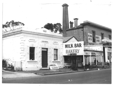
Murray Comrie Collection. This image depicts stores in the main street of Tarnagulla, including the two-storey bank building being used as a licensed general store. The building on the left was also a bank, originally constructed by the Union Bank in 1859, and Is probably the first brick and stone building at Tarnagulla. It was used by the bank until 1888 at which time the Union and Colonial banks amalgamated. After this, the building was used for a variety of purposes. The milk bar section was constructed in the 1920s in an area at the front of what had once been the Bank’s manager’s residence. The Two-story bank building On the right was constructed and used by the Colonial Bank of Australasia (from 1866 to 1888) and, following bank amalgamation, by the Union Bank (from 1888 until closure in 1942). The original site had been occupied by Joseph Foo's store, a large wooden building with attached theatre. While the bank was being built, the Colonial Bank operated from the former Company's Hotel (soon after to become the Borough of Tarnagulla Council Chambers, then the Mechanics’ Institute, and finally, prior to final demolition in 1980, Burstall Hall) The new double-storey building was used by the Colonial Bank from 1866 until 21st February, 1888. The premises were sold to the Union Bank for £2500. The Union Bank moved in and commenced operations on 6th June 1888, continuing until 1942. The building was later used as a general store until the 1990s. It is a now private residence. This is a reasonable copy of an older original. Copy probably made by Murray Comrie in the 1970s. Monochrome photograph depicting a section of Commercial Road, Tarnagulla near the intersection with Poverty Street, including two stores - one a bakery/milk-bar and the other a general store operating in the former Colonial/Union Bank building. Photograph taken from north of milk-bar. Two people walking away from photographer on footpath/curb between the two stores. The building on the left was the Union Bank premises, constructed in 1859 and Tarnagulla's oldest surviving brick building. The Union Bank absorbed the Colonial Bank in 1888, and the Union Bank moved operations next door into the much larger former Colonial Bank premises which had been constructed in 1865/66. After amalgamation, the old Union Bank premises was then used for a variety of purposes from visiting doctor's rooms to cafe, etc. The Union Bank continued to operate at Tarnagulla until closure in 1942, at which time business had fallen away and Tarnagulla Branch had already been downgraded to sub-branch status. tarnagulla, banks, banking, commerce, stores, shopping, shops, food, groceries, buildings, commercial road -
 Melton City Libraries
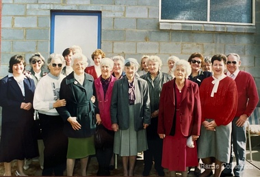
Photograph, Melton Uniting Church Opportunity Shop volunteers, 1993
Melton Uniting Church Opportunity Shop volunteers standing at the cleared site. A week after the demolition of the old church.churches, local identities -
 Melton City Libraries
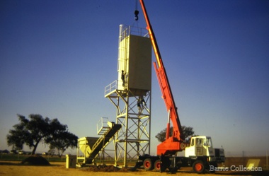
Photograph, Paramount Concrete, c.1972
Paramount Concrete Works tower on the site of Burnbank 1 – Cottage of Henri and Ann nee Dowling Myers side of road east of Myers Gully the junction of Reserve Rd. now known as Ryans Creek. Built c 1870. it remained in the family until a demolition order was placed on it in 1969 when vacated by Martha wife of Frederick 4th son of Ann and Henry. Her new house was built in McKenzie St on the south side near the corner of Smith St. Paramount Concrete established 1972, changed to Readmix Farley in 1983Paramount concrete with cranemisc. -
 Melton City Libraries
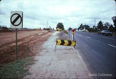
Photograph, Western Highway, 1983
Construction of service road in front of the former Ann Dowling (Miers) 1866 Crown Grant, Title dated October 1870. She married Henri Miers in 1867.Their house was located on the site near the Myers Gully part of Ryans Creek. Built in 1867 and later named “Burnbank” by Martha Myers after the Street in Ballarat were she lived before arriving in Melton in 1907. She married Frederick Myers in 1908. He died in 1963, and Martha moved to a new home at 5 McKenzie Street Melton in 1968. Attempts made by the family to retain the historic cottage were unsuccessful. A demolition order imposed by the Housing Commission and it was pulled down by the family. It was the home of the family and stood for over 100 years.East of Reserve Road towards Ferris Roadlandscapes of significance, misc.