Showing 329 items matching "elm"
-
 Bendigo Historical Society Inc.
Document - MCCOLL, RANKIN AND STANISTREET COLLECTION: EAST CLARENCE GOLD MINING CO - LEASE 10026, 1934/35
Document; Esst Clarence Gold Mining Co - Lease 10026. Lease document for Bendigo 10026 with attached plan - Moon Street, Crowlers Street, Elm Street, Hodgson Street. Attached letter from Dept. Mines about confirming lease marker posts in position. No. 10026 Bendigo.MCCOLL RANKIN & STANISTREETorganization, business, gold mining lease, mccoll rankin & stanistreet -
 Kew Historical Society Inc
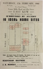
Plan - Subdivision Plan, Subdivision by Auction: 16 Ideal Home Sites, East Kew, 1940, 1940
An advertisement for the sale of a subdivision by Auction: of 16 Ideal Home Sites, East Kew, 1940. This significant sale of land between the Kew Golf Course and Willsmere Park led to the streets having a high degree of architectural uniformity.The subdivision in the second year of the war indicates that land sales for homes and speculation continued from the 1930s into the period of the Second World War. There is no indication on the plan that a war is occurring.Single page subdivision plan advertising the sale by Auction of 16 Ideal Home Sites, in East Kew, on 17 February 1940. Streets named in the plan include: Kilby Road, Belford Road, Elm Grove, Willow Grove. Willsmere Park is indicated but not named. The auction was conducted by Beauchamp Brothers. A number of lots are coloured pink on the plan indicating those lots for sale and/or those already sold.subdivision plans - kew east (vic) -
 University of Melbourne, Burnley Campus Archives
Photograph - Black and white print, Plants, 1919
Black and white photographs of plants in the GardensHandwritten on reverse, "Nov 1919." (1) "Ac. Binervata." (2) "Pillar Rose Marie Henrietta." (3) "Ulmus campestris, Huntingdonton."plants, roses, trees, elm, huntingdon elm, rosa maria henrietta, acacia binervata -
 Nillumbik Shire Council
Sculpture: Michael WILSON (b.1943 Hastings, Victoria), Cicada, 1997
Michael Wilson learnt the craft of Goldsmithing after seeing well known sculptor and silversmith Matcham Skipper working in his studio at Montsalvat in and around 1970. This work is a gift to the Eltham Community in recognition of his twenty five years of developing his goldsmith skills and operating his business within the Shire. Wilson officially opened his commercial premises in 1985. Michael Wilson is a local jewellery maker. His work is influenced directly by the environment in which he lives. This sculpture is representative of his distinctive style of work as a nationally and an internationally recognised Designer and Goldsmith. Made of steel and powdercoated in aluminium with a concrete base. Decorative elements such as the ring encasing the cicada and the cicada's wings are guilded with 24ct gold leaf. The steel rod is burgundy in colour with the cicada painted a dark olive green to represent the 'Green Grocer' variety common in Eltham. The colours used in this sculpture match the surrounding Elm and Ash trees in the landscape. N/Apublic art, cicada, wilson, gold, green grocer, jewellery -
 Whitehorse Historical Society Inc.
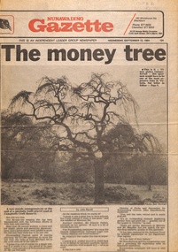
Newspaper - Article, The Money Tree, 12/09/1984 12:00:00 AM
The article describes the decision to move an 80 year old weeping elm tree from Mitcham Road to Campbell's Croft Reserve. The removalist cost of $17,000 raised some objections from local residents. The tree was valued at $100,000 in 1984, described as an outstanding example displaying perfect form and a good size - one of the largest in Victoria.fell, les, trees, campbells croft, city of nunawading, brandenburg, john p -
 Phillip Island and District Historical Society Inc.
Newspaper clippings
Album donated by Miss Edith Elms via Chrisy Northcote. Details from 1758 visit by Bass, Wattle Bark export in 1833, opening of surrounding district with pioneering families, Estate Agent, John Keam & Co and the installation of Postal services in 1873 (brief history of San Remo 1798 - 1928)Two clippings with sub-headings "some early history" - San Remo Heights Estate Hall and San Remo Post Office. Photo of San Remo Port with fishing, boat middle, at top of article large sub-heading "San Remo"Titled San Remolocal history, documents, newspapers, san remo, local area development by europeans, newspapers san remo -
 Bendigo Historical Society Inc.
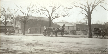
Photograph - HARGREAVES STREET, 1920
Black and white/sepia. Streetscape with horse and carts. Elms in winter and bring building (two stories) together with vacant blocks with piles of bricks (Hargreaves St). Inscriptions: on front - 'Perc Pinder, Bendigo', 'MP 131'. On back - 'MP 131'. 'Hargreaves St between Mundy and Chapel St c.1920 Percival Pinder Photographer', 'Percival Pinder Photographer.Perc Pinderplace, streetscape, hargreaves street, bendigo, transport, horse and cart, buildings, cart, sheds -
 Melbourne Tram Museum
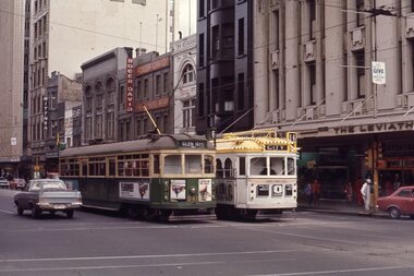
Slide - W6 941 and W7 1024 Swanston St, Ron Hood, 9/1971
Photograph of W6 class tram 941 (Glen Iris, route 6) and W7 1024 (City, route 16) in all-over advertising livery for Channel 0 in Swanston St at Collins St. In the background are Wittner shoes, Roger David men's wear, Elmer house, and The Leviathian store. Photo by Ron Hood Sept.1971.Yields information about tram services in Swanston St and all over advertising tram 1024.Colour slide in a plain cardboard mount.in ink "Collins St, Sept 1971, Melbourne, I had just left New Zealand"tramways, swanston st, w6 class, tram 941, decorated trams, w7 class, tram 1024, channel 0 -
 Kew Historical Society Inc
Plan, Melbourne & Metropolitan Board of Works : Borough of Kew : Detail Plan No.1576, 1904
The Melbourne and Metropolitan Board of Works (MMBW) plans were produced from the 1890s to the 1950s. They were crucial to the design and development of Melbourne's sewerage and drainage system. The plans, at a scale of 40 feet to 1 inch (1:480), provide a detailed historical record of Melbourne streetscapes and environmental features. Each plan covers one or two street blocks (roughly six streets), showing details of buildings, including garden layouts and ownership boundaries, and features such as laneways, drains, bridges, parks, municipal boundaries and other prominent landmarks as they existed at the time each plan was produced. (Source: State Library of Victoria)This plan forms part of a large group of MMBW plans and maps that was donated to the Society by the Mr Poulter, City Engineer of the City of Kew in 1989. Within this collection, thirty-five hand-coloured plans, backed with linen, are of statewide significance as they include annotations that provide details of construction materials used in buildings in the first decade of the 20th century as well as additional information about land ownership and usage. The copies in the Public Record Office Victoria and the State Library of Victoria are monochrome versions which do not denote building materials so that the maps in this collection are invaluable and unique tools for researchers and heritage consultants. A number of the plans are not held in the collection of the State Library of Victoria so they have the additional attribute of rarity.Original survey plan, issued by the MMBW to a contractor with responsibility for constructing sewers in the area identified on the plan within the Borough of Kew. The plan was at some stage hand-coloured, possibly by the contractor, but more likely by officers working in the Engineering Department of the Borough and later Town, then City of Kew. The hand-coloured sections of buildings on the plan were used to denote masonry or brick constructions (pink), weatherboard constructions (yellow), and public buildings (grey). Development in the 20th century has irreparably altered that part of Kew represented in this plan. In the block bounded by Cotham Road, Charles Street, Wellington Street and Gellibrand; just one house standing in 1903 remains. This block included two of the most historic houses in Kew: ‘Ordsall’ (later ‘Southesk’) and ‘Madford’ (previously ‘Elm Lodge’). Ordsall was the home of the second chairman of Kew, John Halfey. It contained some of the most significant interior murals in Kew, created for Halfey by artists working for Cullen & Co. It was demolished in 1960 to make way for the Kew Civic Centre. Elm Lodge had been built for William Siddeley in ca. 1864. Arthur Septimus King purchased it in 1874. The lower paddocks of Madford were sold in 1905 by his wife to the Borough of Kew and, after landscaping by George and Thomas Pockett, opened as the Alexandra Gardens in 1908. Elm Lodge/Madford was in 1922 to become St. Anthony’s Home for Little Children before its subsequent demolition in the 1980s.melbourne and metropolitan board of works, detail plans, maps - borough of kew, mmbw 1576, cartography -
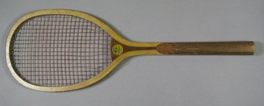 Tennis Australia
Racquet, Circa 1905
A wooden Horsman 'Model G' tennis racquet, with oriental gut (silk) strings, laminated convex throat, and, a rounded handle. Inscription across crown, on obverse: MODEL G. Horsman 'Centaur' trademark features on throat, on obverse. On throat, on reverse, is a moon-face sticker with inscr. 'THANKS' across top. Carved inscr. along shaft on obverse: ELMER. Materials: Wood, Metal, Lacquer, Ink, Glue, Silktennis -
 National Wool Museum
Book - Pattern Book, Patons Knitting Book, No.1089, Patons and Baldwins, 1990s
Eight page knitting pattern book featuring black and white text and colour images. The colour cover features an image of the cartoon character Daffy Duck.front: [printed] 1089 / Patons / PRICE CODE K / Daffy Duck TM / with ELMER FUDD TM / 4 Knitting / patterns / for children and adults / BY GARY KENNEDY (INTARSIA UK) / TM & c Warner Bros. Inc. 1991. All Rights Reserved.fashion, design, knitwear, home made, wool, pattern book, patons -
 Kew Historical Society Inc
Plan - Subdivision Plan, J R Mathers & McMillan, Willsmere Park Estate, c.1940
Pru Sanderson, in her groundbreaking ‘City of Kew Urban Conservation Study : Volume 2 - Development History’ (1988), summarised the periods of urban development and subdivisions of land in Kew. The periods that she identified included 1845-1880, 1880-1893, 1893-1921, 1921-1933, 1933-1943, and Post-War Development. These periods were selected as they represented periods of rapid growth or decline in urban development. An obvious starting point for Sanderson’s groupings involved population growth and the associated economic cycles. These cycles also highlighted urban expansion onto land that was predominantly rural, although in other cases it represented the decline and breakup of large estates. A number of the plans in the Kew Historical Society’s collection can also be found in other collections, such as those of the State Library of Victoria and the Boroondara Library Service. A number are however unique to the collection.The Kew Historical Society collection includes almost 100 subdivision plans pertaining to suburbs of the City of Melbourne. Most of these are of Kew, Kew East or Studley Park, although a smaller number are plans of Camberwell, Deepdene, Balwyn and Hawthorn. It is believed that the majority of the plans were gifted to the Society by persons connected with the real estate firm - J. R. Mathers and McMillan, 136 Cotham Road, Kew. The Plans in the collection are rarely in pristine form, being working plans on which the agent would write notes and record lots sold and the prices of these. The subdivision plans are historically significant examples of the growth of urban Melbourne from the beginning of the 20th Century up until the 1980s. A number of the plans are double-sided and often include a photograph on the reverse. A number of the latter are by noted photographers such as J.E. Barnes. In 1910, the Willsmere Park Estate Dairy was lauded in the Box Hill Reporter as ‘an object lesson in dairying’. Ten years later, in 1923, it was to be sold. The first subdivision of the Estate included 77 grand allotments with frontages to Belford and Kilby Roads, Elm and Willow Groves, and Acacia Avenue. Every lot was claimed to be ‘high and dry’, and with panoramic views of Kew and East Kew. The balance of the Estate, and the largest proportion of allotments was to be subdivided and sold from 1940. This second sale included 109 lots fronting Kilby Road and Elm and Willow Groves. Annotations on the plan indicate that the more expensive lots faced Belford Road opposite the Kew Golf Links. Two of these sold for £310. Lots further to the west in Willow Grove were sold for £60 less. Many of the houses to be built on these 109 allotments after the War faced Government restrictions on building materials and the dimensions of each house due to postwar shortages.subdivision plans - east kew, willsmere park estate -
 University of Melbourne, Burnley Campus Archives
Photograph - Sepia print, A.E. Bennett, Entrance Gates, 1894-1990
Note by E.B. Littlejohn, "Is the roadway the original Swan Street? Entrance gates to Gardens in the distance. Roadway leading to the Pavilion hidden behind the trees. No elms showing along the roadway," and by T.H. Kneen, "The roadway appears to terminate at the gates outside the Curator's Residence, sweeping past the Pavilion on the right. I have seen a plan which showed an attractive avenue of trees (pine) from the western end of the property (where the Stockman's Cottage was later sited.)" 2 copies sepia photograph. Copy of sepia photograph of the roadway to the Entrance Gates and Curator's Cottage seen in the distance, with the Pavilion on the right, in, "Prize Essays," Alfred E. Bennett, c.1894, after p 116. Pinus radiata avenue on each side of the road.entrance gates, prize essays, alfred e. bennett, curator's residence, pavilion, stockman's cottage, pine tree avenue -
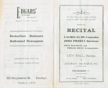 Bendigo Historical Society Inc.
Document - RECITAL BY LAURIS ELMS, JOHN PROBYN, GWEN HALSTEAD, AND PHYLLIS AT CITY HALL BENDIGO
The Music Advancement Society of Bendigo presents the First Concert 1961 series, presenting recital by Lauris Elms, (contralto), John Probyn, (baritone), Gwen Halstead and Phyllis Probyn (accompanistes). At City Hall, Bendigo on Saturday, 18th March, 1961 at 8.15pm. Hon. Secretaries: Madge Edgar and Mary Stanistreet. Advertisement on back for Edgars Authorised Newsagency, 293 hargreaves Street Bendigo, Telephone 3-4738. Printi ng by Boltons print Bendigo.entertainment, music, classical -
 Department of Energy, Environment and Climate Action
Hasselblad aerial camera
Aerial photos were used to make maps of forest types, timber resources, to survey logging areas and regeneration, to mark boundaries of public land and new plantations, to identify new roads and tracks, as well as for fire suppression. Infrared film was sometimes used to monitor insect and disease attack. The images needed to sharp, with high contrast, and in a large format (most were printed in B&W on 9-inch by 9-inch glossy photographic paper) with at least a 60% overlap to enable stereoscopic viewing and with a 20-30% side lap to allow for aircraft drift. Preferably, the photo scale was close to the final map scale avoid to problems when enlarging and to reduce distortion. Something was needed to supplement the very expensive and infrequent large-area photography programs. From the mid-1960s Victorian foresters began experimenting with small format 70mm and 35mm cameras which proved simple, practical, cheap and flexible. It was found that any SLR camera could be used provided it had a good quality lens and fast shutter speed (preferably down to 1/1000 second). Motorised cameras with a large film capacity had obvious advantages and were essential when access to the camera was not possible during flight. It is also essential for the shutter to operate at low temperatures and those lubricated with silicones were recommended. Components of a typical FCV Divisional Office system included – A Hasselblad or Vinten 70 mm format aerial camera with a focal plane shutter which could be electrically operated. Interchangeable lenses to allow for different photo scales and flying heights. Several large film magazines, which were loaded in a darkroom, each with a capacity of 100 feet or approximately 500 frames. A remote control for the camera in single-shot mode or automatic firing at selected intervals of 2 to 50 seconds. It also needed a frame counter. A light aircraft was modified with an internal mounting for the camera to keep it level and steady. Often a hole was cut through the floor for the lens. The aircraft also needed an inbuilt 12 Volt DC battery to operate the motorised camera shutter. The front passenger seat was generally removed to improve access to the camera. An Aldis drift sight was also fitted. This might be likened to an inverted periscope and is used to determine drift, to facilitate accurate navigation along flight lines and to determine the exposure interval for stereoscopic overlap. This item is kept at Traralgon.Hasselblad 500 ELM camera with 70mm lens, film pack, motor drive and battery In 1964 Hasselblad started production of a motorized camera, the 500 EL The EL/M is a modified version of the EL, "M" means modified, "EL" electric. Perhaps the most famous use of the Hasselblad camera was during the Apollo program missions when man first landed on the Moon. Almost all of the still photographs taken during these missions used modified Hasselblad cameras. forests commission victoria (fcv), forest measurement, surveying, mapping -
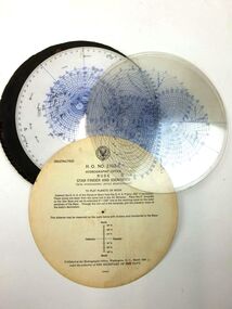 Moorabbin Air Museum
Equipment (item) - Rude Star Identifier with Hydrographic Modifications A N Type 1 Hydrographic Office No. 2102-C, Star Identifier
This star finder, designed for aeronautical use, was based on the Rude form as modified by Elmer Collins of the United States Hydrographic Office. It consists of a white plastic planisphere with the northern sky on one side and the southern on the other that shows all the stars in the American and the British Air Almanacs; nine clear plastic altitude-azimuth templates for use at different latitudes up to 85° north and south; an instruction card; and a leatherette container. It was published in March 1942 under the authority of the Secretary of the Navy, and cost $2.50. -
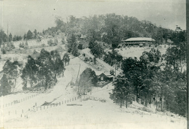 Mt Dandenong & District Historical Society Inc.
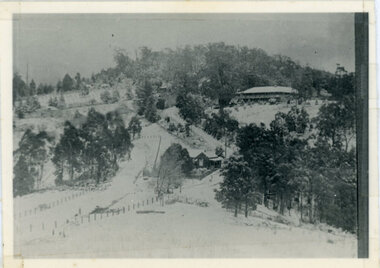
Photograph, The Gap Under Snow 1921, 1921
Snow scene looking up through The Gap (FiveWays) with Mountjoy Guest House on the hill to the right. The shop and post office are seen in the centre of the picture. This photograph has a detailed inscription on the back handwritten by John Lundy-Clarke in 1974.The Gap under snow 1921. “Mountjoy” on hill. New CRB road formation (unmetalled) comes into picture lower left corner, passes left of dray under the elms, then circles around behind the trees behind Miss Hands shop and home and Post Office (Mt Dandenong North) to pass out of picture left in centre of picture. It passes between Ted Prices Hay & Corn store and Walker’s house where the Estate Agency was later placed. Main Road then in centre of picture bend right behind Mountjoy. Price’s house and shop behind the blackwood left of road bend. CRB cuts across Barbers left of Elm trees.john lundy-clarke, kalorama, mountjoy, mountjoy, the gap, post office, mt dandenong north, snow -
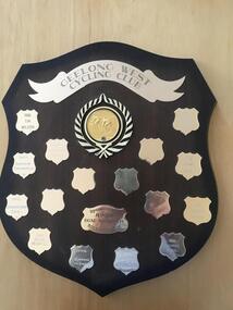 Geelong Cycling Club
Shield
This shield records the junior cyclists who were high achievers in the Geelong region during this period.Indicates the boom time experienced for Junior Cyclists at the Geelong Cycling Club during the late 1990s and early 2000.A mahogany coloured wooden shield with brass plated plaques containing inscriptions of winners of the Junior Track Aggregate races during the years 1997-2007. There is an emblem of a cyclist and a banner at the top centre of the shield. "Geelong West Cycling Club/Junior Track Aggregate/Sponsored by F & S Newton/1997/Ryan Moody/1998/Tim Buckley/1999/Renee Hoppen/2000/Daniel Hudgell/2001/Matt Pope/2002/Chesney Milne/2003/Josh Beer/2004 Mitchell Elmer/2005/Leigh Howard"geelong west cycling club; junior track aggregate; sponsored by f & s newton; ryan moody; tim buckley; renee hoppen; daniel hudgell; matt pope; chesney milne; josh beer; mitchell elme; leigh howard; -
 Kew Historical Society Inc
Plan - Willsmere Park Estate, Kew, 1926
Subdivision plans and real estate flyers/brochures reveal a number of aspects of urban development and history. The Kew Historical Society's collection of these plans, as well as advertisements extracted from magazines, cover key aspects of community development and architectural history of Kew and Kew Eat as well as surrounding suburbs. While most of the plans in the collection were gifted to the Society by the former City of Kew, a number of other plans and advertisements have been donated by individuals, of which this is an example.Original 4-page, bifold subdivision plan of the Willsmere Park Estate, Kew. The 1926 land sale advertised '40 superb villa allotments' on the 'Yarra Heights'. Streets within the subdivision included: Willow Grove, Kilby Road, Elm Grove and Belford Road. The double page spread on pages 2 and 3 shows the detailed plan of the 40 lots, surrounded by public parkland [Willsmere Park] and the Kew Golf Links. By the time that this version of the plan was released, only the lots on Willow Grove and Kilby Road remained. willsmere park estate -- kew (vic.), subdivisions - kew (vic.), subdivisions -- kew east (vic.), willsmere park -- kew east (vic.) -
Clunes Museum
Weapon - NAVAL CANNON, 1847
IT IS ON PERMAMENT LOAN FROM HEPBURN SHIRE THE CANNON WAS ORIGINALLY ON THE BRITISH NAVAL SHIP "NELSON" IN FEBRUARY 1867. "NELSON" WAS HANDED OVER TO THE VICTORIAN NAVAL FORCES, ON LOAN FROM THE ROYAL NAVY. "NELSON" WAS SOLD 1898, IT IS BELIEVED THAT THE GUNS WERE THEN OFFERED FOR SALE TO COUNCILS. IT WAS DISPLAYED ON A SITE NEAR THE SCENIC ROAD, CLUNES, UNTIL THE WOODEN UNDERCARRIAGE WAS DESTROYED BY THE BUSHFIRES IN 1944. IT WAS LATER RETRIEVED AND KEPT IN THE CLUNES BOROUGH COUNCIL YARD UNTIL IT WAS RESTORED BY THE APPRENTICES AT THE BENDIGO ORDNANCE WORKSHOPS IN 1895. THE TIMBER USED FOR THE RESTORATION WAS TAKEN FROM AN ELM TREE NEAR THE CREEK IN CLUNES..1 NAVAL CANNON MOUNTED ON A WOODEN UNDERCARRIAGE. .2 CANNON BALLlocal history, military history, navy, military -
 Ringwood and District Historical Society
Document - Map, Part of Crown Allotment 27C, Parish of Warrandyte, County of Evelyn, Ringwood, Victoria - c.1970
Photocopy of subdivision plan 75131 Vol 3439 Fol 712 showing numbered residential allotments with property dimensions.Surveyors and Consulting Engineers - O'Connor & Beveridge, Main Eltham Road, Lower Plenty, Tel. 432668. Rubber-stamped "Photocopy - Titles Office Complied 17 Feb 1970". Map includes Lockhart Road, Lansell Close, Terrara Place, Goldsmith Avenue, Park Hill Drive, Hilldale Close, and Elm Court, Ringwood, Victoria. -
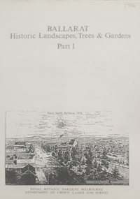 Federation University Historical Collection
Book, Peter Lumley et al, Ballarat: Historic Landscapes, Trees & Gardens, 1983, 1983
Lisa Green and Lisa Morcom of Ballarat College of Advanced Educatiion contributed to this report.275 page landscape study of Ballarat including Trees in the Victorian Landscape; Plant sources early Ballarat nurseries, Botanical Gardens, Lake Wendouree, Fairy Gardens, Victoria Park, Ballaarat Old Cemetery, Eastern Oval, City Oval, Ballarat East Town Hall Gardens, Eureka Stockade, Observatory, Yarrowee, Black Hill, Sovereign Hill, Cheek Channels, Canadian Creek, Poverty Point Reserve, Goldmining Relics, Woah Hawp, Buninyong, street plantings, Russell, Victoria, Bridge Mall, Sturt Street Gardens, Avenue of Honour, Webster, Elms, ballarat, trees, nursery, r.u. nicholls, francis moss, ballarat botanical gardens, victoria park, lake wendouree, ballaarat old cemetery, eastern oval, ballarat east town hall gardens, ballarat school of mines botanical gardens, eureka stckade recreation reserve, ballarat observatory, yarrowee creek, black hill reserve, sovereign hill, ballarat avenue of honour, victoria street plantings, bridge mall plantings, george longley -
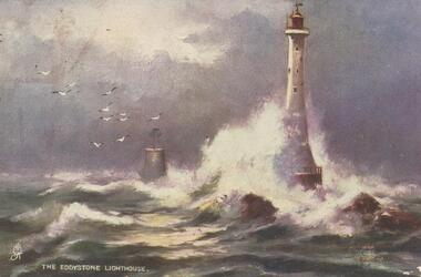 Bendigo Historical Society Inc.
Postcard - GLADYS DEAN COLLECTION: POSTCARD, 1906 - 1908
Printed coloured postcard. Image is of The Eddystone Lighthouse and depicts a lighthouse on rocks with a smaller brick structure nearby in stormy seas and gulls in the sky. The words The Eddystone Lighthouse with a small symbol in white appear along the bottom left hand edge. Reverse is addressed to Miss Dean 'Esmond' Golden Square Bendigo and has a one penny stamp affixed postmarked Kerang. The words Raphael Tuck and Sons "Oilette" (Regd) postcard 7062 "Rough Seas" Art Publishers to Their Majesties the King and Queen after the black and white originals by Elmer Keene are printed in red along the left hand edge.Raphael Tuck and Sons 'Oilette' Regd Postcard 7062 'Rough Seas'postcard -
Whitehorse Historical Society Inc.
Letter - Correspondence, House 113 Springvale Road, Nunawading, n.d
A letter from Nance Leach (undated) telling the history of John McClelland's house. He arrived from Ireland in 1863...5 years later they selected 80 acres at Tunstall (Nunawading) and cultivated a market garden, The property was on the site of Stanley Engineering. The couple and one daughter retained the house and Whitehorse Road section of the property about 1948. This was sold to 'Turners' on condition Turners removed the house to 113 Springvale Road for Miss Tess McClelland. When she died the house was sold to Hal Johnson and he later sold it to Mr Florio. John McClelland died 1911 aged 77. The house was called 'The Elms'.springvale road, nunawading, no 113 (the elms), nunawading, mcclelland, john, stanley works pty ltd, turner industries, mcclelland, tess, johnson, hal, florio (mr) -
 Port Melbourne Historical & Preservation Society
Photograph - Nicholas Family, Port Melbourne, 1935 - 1964
Photographs as numbered: 1) Mary NICHOLAS on Port Melbourne beach holding Elizabeth NICHOLAS in 1935. 2) Edward &^ Elizabeth NICHOLAS with friend in backyard 89 Bay Street, port Melbourne. 3) Oriana about to depart Station Pier possibly November 1964. 4) August 1948 photograph taken in back yard of 89 Bay Street. L - R Back row: Allan & Mary NICHOLAS; Henry HAWKINS (Mary's stepfather). L - R Middle row: Edward, Elizabeth & Maxwell HAWKINS, Charlotte HAWKINS. Front row - unknown. 5) Elizabeth NICHOLAS in back yard 89 Bay Street. The ELMS family, the father was a grocer & his two sons, Ron & Norman, lived at number 87.. An A4 size page with five B&W photographs relating to the Nicholas family.Each photograph identified with a number 1 - 5.built environment - domestic, mary nicholas, elizabeth nicholas, transport - shipping, oriana, allan nicholas, henry hawkins, maxwell nicholas, charlotte hawkins (bennett), elms family, david thornton, edward nicholas, piers and wharves - station pier, graham street, bay street -
 Mt Dandenong & District Historical Society Inc.
Photograph, Kalorama Gap Under Snow 1921, 1921
View of Kalorama Gap under snow taken in 1921. Mountjoy Guest House is at top right and Beulah Tea Rooms is in the centre. This photograph has a detailed inscription on the back handwritten by John Lundy-Clarke in 1974.Kalorama Gap under snow 1921 The leafless elm trees are low in the centre and the dual nature of the nearer one can be clearly seen, two small suckers of the older farther tree being twisted together in 1898 by Fred Jeeves. The older tree was planted 1880. Mrs Hands shop can be clearly seen, which was the Mount Dandenong North Post Office. The old Main Road runs up the centre of the picture and turns to the right and disappears behind “Mountjoy” the big guest house built by Paynters in 1905 and sold to Ellis Jeeves 1908, whose family ran it till 1943. At the bend of the road behind the big pine tree and the dark blackwood can be seen faintly the gable of Price’s house that contained the first shop on the mount. Above it is H Walker’s cottage on Ridge Road that still exists, his homestead is on the left of the picture on the same level. Below this house and to the left can be seen Ted Prices hay and corn store. The present estate agency lies between these two buildings, on the road which had recently been built. This can be seen winding from the lower left corner of picture to the left of the elms. The CRB had recently fenced the road and this is clearly seen as it circles behind trees in the left centre. Barber’s Road crosses CRB Road to the left of the dray under the leafless elm and the Coach Road dives down to the right just behind the pair of blackwoods to right of the elms. The picture was taken from just above the boundary of Isaac Jeeves’s selection Crown Allotment “C” (Jeeves Saddle) which stretched across the Gap to the other side of Mrs Hand’s shop, monopolising the gap from 1871 to 1879. Price’s house remains partly as the small house – “Mirra Laken”. kalorama gap, fiveways, post office, mountjoy, guest house, snow -
 Bendigo Historical Society Inc.
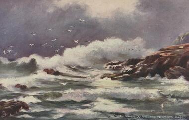
Postcard - GLADYS DEAN COLLECTION: POSTCARD, 1906 - 1908
Coloured printed postcard. Image is of a painting entitled 'When waves do rise and tempests rage'. A stormy sea with large waves crashing onto rocks. Gulls are in the sky against a cloudy background. The words When waves do rise and tempests rage are printed in white along the bottom right hand edge. On the reverse it is addressed to Miss Dean Esmond Golden Square Bendigo. A one penny stamp is affixed and is postmarked Kerang. The words Raphael Tuck and Sons 'Oilette" (regd) Postcard 7062 "Rough Seas" Art Publishers to Their Majesties The King and Queen After the black and white originals by Elmer Keene are printed in red along the left hand edge.postcard -
University of Melbourne, Burnley Campus Archives
Album - Black and white and sepia prints, Gardens Other Than Burnley, 1890-1920
Identification and information on reverse of some photographs given by Georgina Whitehead (Tel-9572 1225) who visited the Archives on 26 September, 1995 when she was writing a book on the various gardens owned and run by the Melbourne City Council-'Civilizing the city: a history of Melbourne's public gardens,' State Library of Victoria, Melbourne 1997.34 bkack and white and sepia photographs. Possibly used for Magic Lantern slides. Fitzroy Gardens: (1) Possibly, towards St Patrick's Cathedral. (2, 3) Path through avenue of trees. (4) Winter. Heavily pruned Elms. (5) Looking towards Clarendon St-eastwards. (6) Probably, lawn. (7) 2 copies, possibly Kiosk. (8) 1920's or earlier. Man sitting on bench. (9) Path through avenue of trees. (10) 2 copies. Probably-fenced originally-fences coming down 1890's on. (11) Statue at crossroad. (12) The Vase Fountain. (13) Tree trunks. (14) Tree trunks. (15) Probably, tree trunks. (16) Winding path. (17) Probably, misty winter scene. (18) Probably, summer. (19) Probably, this is the sort of garden seat used. (20) Avenue of trees, information about exposure on reverse. (21) 2 copies. Probably. Treasury Gardens: (22) Japanese Garden. (23)Japanese Garden. This area around the Lake done by Guilfoyle c.1901-1902. This photograph about this period. (24) Gardener at lake edge. Snowdon Gardens: (25) View towards city. Unidentified: (26) ?Botanic fern Gully/ Fitzroy Fern Gully. (27) Lake view. (28) Narrow path through long grass and trees. (29) Trees in winter. (30, 30a) Tree ferns. (31,32) Cordylines. (33) People on lawn. (34) Winter view of path through elms. These photographs have been scanned but have not been uploaded.georgina whitehead, fitzroy gardens, trees, elms, the vase fountain, trunks, treasury gardens, japanese garden, guilfoyle, snowdon gardens, fern gully, lake view, parks -
 The Beechworth Burke Museum
Photograph - Stereoscopic Photograph, c1900
The gardens of Ovens District Hospital were laid out and planted by R H Jenkyns in 1874. Over 200 species of trees and shrubs were planted, including several large Himalayan Cedars (Cedrus deodora), a Coast Redwood (Sequoia sempervirens), rare Scots Pine (Pinus sylvestris), Pencil Cedar (Juniperus virginiana), Bunya Bunya Pines (Araucaria bidwillii), a Purple-leaved Dutch Elm (Ulmus x hollandica 'Purpurascens'), American Ash (Fraxinus americana), Pinus radiata, and numerous Populus alba trees and suckers. The gardens were considered integral to the healing process, also including orchards and kitchen gardens. In the 1880s, tourists flocked to Beechworth as the area became recognised as a health resort and picturesque beauty spot. Although the hospital closed in 1940, and parts were subsequently demolished, the gardens remain and form part of the site's listing on the Victorian Heritage Register. This photograph is part of a collection of items held by the Burke Museum relating to Ovens District Hospital. At the time of being built, the Ovens District Hospital was the only hospital between Melbourne, Victoria, and Goulburn, New South Wales, treating patients from all of north-east Victoria, including Indigo Shire.Black and white stereoscopic photograph mounted on card.Reverse: 97-2292 / View up centre path of Hospital / A03177 / BMM3177 / Note: A03178 / View of the central path of the Ovens Hospital / (Church St) Beechworthovens hospital, hospital garden, gardens and parks, ovens district hospital -
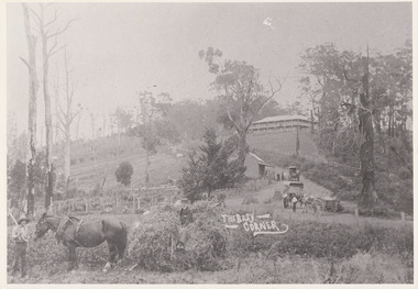 Mt Dandenong & District Historical Society Inc.
Photograph, The Busy Corner, 1907
View of Jeeves Saddle in 1907 showing everyday life and including important people and businesses from early settlement - Dodd's grocery and meat cutting carts; Beulah tea Rooms/Post Office; Mrs Hand, Fred Jeeves, Theo Hand.This photograph has a detailed inscription on the back handwritten by John Lundy-Clarke in 1974.“Jeeves Saddle” in 1907. Isaac Jeeves special strip of land Crown Allotment “C” 7 chains wide, lay between the sledge load of pea stalks and the far end of the verandah on Mrs Hand’s “Beulah Tea Rooms” which soon afterwards became the Mt Dandenong North Post Office. The coach road came up from the right behind the tall stump. The big woman in black was Mrs Hand. The wagon at the shop was Dodd’s grocery cart. The nearer wagon was the first coach on the mountain which had belonged to Briarty. The small cart was Dodd’s meat cutting cart. The elm trees are in the centre of the picture and above them is Price’s sign advertising their shop and newsagency. The big house is “Mountjoy” burnt 1975. Walker’s house is among the big trees left centre. Boy at horse’s head is Fred Jeeves. Boy on sledge is Theo Hand. The horse is “Blossom”. Barbers Road goes to the left from behind the elm trees.jeeves, theo hand, fred jeeves, isaac jeeves, barbers road, beulah tea rooms, post office, mount dandenong north, mt dandenong north, kalorama, coach, mountjoy