Showing 468 items matching "heritage studies"
-
 Glen Eira Historical Society
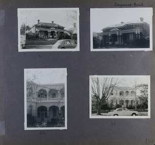
Album - Album page, Seymour Road, Circa 1972
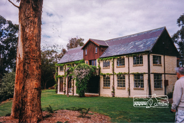
... to Andrew Ward's Heritage Study) was originally named Beemery.... to Andrew Ward's Heritage Study) was originally named Beemery ...This album was created in approximately 1972 as part of a project by the Caulfield Historical Society to assist in identifying buildings worthy of preservation. The album is related to a Survey the Caulfield Historical Society developed in collaboration with the National Trust of Australia (Victoria) and Caulfield City Council to identify historic buildings within the City of Caulfield that warranted the protection of a National Trust Classification. Principal photographer thought to be Trevor Hart, member of Caulfield Historical Society. Most photographs were taken between 1966-1972 with a small number of photographs being older and from unknown sources. All photographs are black and white except where stated, with 386 photographs over 198 pages. As at 22/08/2021, 51 Seymour Road is included in the HO179 Beemery Park Precinct which C204glen Amendment seeks to add to the Glen Eira Planning Scheme (amongst others). This is not yet finalised. Bellecourt (so named in 1989 according to Andrew Ward's Heritage Study) was originally named Beemery.Victorian Heritage Database HO62 Bellecourt 85 Seymour Road ELSTERNWICK https://vhd.heritagecouncil.vic.gov.au/places/35585 (as of 22/08/2021) "Beemery" at 85 Seymour Road, is an imposing ltalianate villa with arcaded asymmetrical facade built in 1891 for Charles Langdon. It has aesthetic, historical and social significance. Its aesthetic value rests with the facade which is highly representative of a not uncommon villa form of the late Victorian period. Its historical value derives from its association with the Langdon family in Caulfield (compare "Rosecraddock", "Tarqua" and "Hengar"). Its social value derives from its ability to demonstrate a lifestyle in late Victorian Caulfield.Page 190 of Photograph Album with four photographs of two different properties on Seymour Road.Handwritten: Seymour Road [top right] / 51 [under top left photo] / 51 [under top right photo] / 85 [under bottom left photo] / 85 [under bottom right photo] / 190 [bottom right]trevor hart, elsternwick, seymour road, late victorian, caulfield, beemery, bellecourt, house names, langdon family, charles langdon, cast iron work, verandahs, polychromatic brickwork, italianate style, arched balconies -
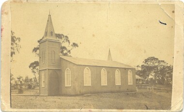
 Melton City Libraries
Photograph, Myers family members at Uniting Church, 1986
... of Melton Heritage Study Stage 2 Volume 6 David Moloney 2007 ..., in the Shire of Melton. Information from Shire of Melton Heritage ...The Uniting Church (originally the Scots Presbyterian Church) was built 1865-67) and adjacent former Church Hall / Sunday School (built 1938), Yuille Street, Melton. The adjacent former church hall, now kindergarten facility. The Uniting Church and former church hall are historically significant at a Local level (AHC A4). It was built after Melton’s ‘United’ church and school, erected by Protestant denominations in 1857 in an effort to share resources in the pioneering era, was replaced by individual churches in the 1860s. The church became the home of and is expressive of the union of the Methodist and Presbyterian churches, begun in Melton from the early 1970s, and formally concluded by the formation of the Uniting Church of Australia in 1977. The new additions and functions of the church are expressive of the increase in Melton’s population especially in the 1970s, and the changing nature of the parish’s ministry. The church is one of only three remaining nineteenth century churches, and one of only two remaining bluestone churches, in the Shire of Melton. Information from Shire of Melton Heritage Study Stage 2 Volume 6 David Moloney 2007 At the opening of the new extension to the churchlocal identities, churches -
 Eltham District Historical Society Inc
Folder, Shire of Eltham Living and Learning Centre, 1996
... , harry gilham collection, heritage study, history, joanne osborne... of Eltham Heritage Study, pages 930-936 with notations ... of Eltham Heritage Study, pages 930-936 with notations eltham living ...Contents: 1. Hand drawn schematic record of site buildings as of 1975 compiled by Harry Gilham, Shire of Eltham Historical Society 2. History compiled on the ocassion of the Eltham Living and Learning Centre's 21st birthday in 1996. Includes historical notes about the property, origins of the Living and Learning Centre at Eltham which started in 1975. List of associate groups, friends of the creek, friends of the centre, playhouse, list of co-ordinators 3. Enrolment Day Cake recipe 4. Poem - "Who'd be a co-ordinator" by unknown 5. Traditions and Memories by Margaret Johnson, Program Co-ordinator for 10 years 6. Reminiscences by Linda Kirkwright, Admin Assistant 7. In the beginning there was a small cottage ... by Joanne Osborne, Assistant Co-ordinator 1977-1980 8. Newsclippings - Living and Learning Centre in Council Centre, Diamond Valley New, 2 Apr 1975; 'Rub-A-Dub" unknown publication; and miscellaneous advertisements 9. Copy of certifcate of title when transferred to the Shire of Eltham in 1975 10. Copy of 1992 Shire of Eltham Heritage Study, pages 930-936 with notations 48 A4 pages photocopies HG Booklets 22 and 47, 64eltham living and learning centre, enrolment day cake, harry gilham collection, heritage study, history, joanne osborne, linda kirkwright, margaret johnson, poem, recipe, reminiscences, who'd be a co-ordinator -
 Eltham District Historical Society Inc
Photograph, Peter Bassett-Smith, Eltham Mud Brick Heritage Excursion, 4 October 1998, 04/10/1998
... of earth houses listed by the Eltham Heritage Study in a very... of earth houses listed by the Eltham Heritage Study in a very ...[article in EDHS Newsletter No. 123, November 1998:] MUD BRICK HERITAGE EXCURSION AND THE FUTURE. A small group of members attended the excursion on 4th October. We visited a number of earth houses listed by the Eltham Heritage Study in a very pleasant day's outing. The first visit was to the home of Jenny and Brian Ellis in York Street, formerly the home of Jenny's father Professor William McMahon Ball. We were made very welcome with inspection of the inside and outside showing the various stages of construction. We then walked through the grounds of "Kinloch", the Jelbart property in Arthur Street where we saw their large mud brick house and barn. Lunch was at Marion and Russell Yeoman's house in Peter Street. This pise house was built by the Moore family in the early 1950's. In the afternoon we visited the home of artist Jenni Mitchell in Fordhams Road, one of the last examples of the work of Alistair Knox. Then we travelled to Laughing Waters Road where we saw two interesting houses owned and built by well known landscape gardener Gordon Ford. Along the way we stopped to view a number of other properties from the street.Colour photographactivities, eltham, heritage excursion, mud brick -
 Eltham District Historical Society Inc
Photograph, Peter Bassett-Smith, Boomerang House, Laughing Waters Road, Eltham; Eltham Mud Brick Heritage Excursion, 4 October 1998, 04/10/1998
... of earth houses listed by the Eltham Heritage Study in a very... of earth houses listed by the Eltham Heritage Study in a very ...[article in EDHS Newsletter No. 123, November 1998:] MUD BRICK HERITAGE EXCURSION AND THE FUTURE. A small group of members attended the excursion on 4th October. We visited a number of earth houses listed by the Eltham Heritage Study in a very pleasant day's outing. The first visit was to the home of Jenny and Brian Ellis in York Street, formerly the home of Jenny's father Professor William McMahon Ball. We were made very welcome with inspection of the inside and outside showing the various stages of construction. We then walked through the grounds of "Kinloch", the Jelbart property in Arthur Street where we saw their large mud brick house and barn. Lunch was at Marion and Russell Yeoman's house in Peter Street. This pise house was built by the Moore family in the early 1950's. In the afternoon we visited the home of artist Jenni Mitchell in Fordhams Road, one of the last examples of the work of Alistair Knox. Then we travelled to Laughing Waters Road where we saw two interesting houses owned and built by well known landscape gardener Gordon Ford. Along the way we stopped to view a number of other properties from the street.Colour photographactivities, eltham, heritage excursion, mud brick, boomerang house, laughing waters road -
 Eltham District Historical Society Inc
Photograph, Peter Bassett-Smith, Rocknall, 25 Diamond Street, Eltham; Eltham Mud Brick Heritage Excursion, 4 October 1998, 04/10/1998
... of earth houses listed by the Eltham Heritage Study in a very... of earth houses listed by the Eltham Heritage Study in a very ...[article in EDHS Newsletter No. 123, November 1998:] MUD BRICK HERITAGE EXCURSION AND THE FUTURE. A small group of members attended the excursion on 4th October. We visited a number of earth houses listed by the Eltham Heritage Study in a very pleasant day's outing. The first visit was to the home of Jenny and Brian Ellis in York Street, formerly the home of Jenny's father Professor William McMahon Ball. We were made very welcome with inspection of the inside and outside showing the various stages of construction. We then walked through the grounds of "Kinloch", the Jelbart property in Arthur Street where we saw their large mud brick house and barn. Lunch was at Marion and Russell Yeoman's house in Peter Street. This pise house was built by the Moore family in the early 1950's. In the afternoon we visited the home of artist Jenni Mitchell in Fordhams Road, one of the last examples of the work of Alistair Knox. Then we travelled to Laughing Waters Road where we saw two interesting houses owned and built by well known landscape gardener Gordon Ford. Along the way we stopped to view a number of other properties from the street.Colour photographactivities, eltham, heritage excursion, mud brick, diamond street, rocknall -
 Eltham District Historical Society Inc
Photograph, Peter Bassett-Smith, Jelbart property, Arthur Street, Eltham Mud Brick Heritage Excursion, 4 October 1998, 04/10/1998
... of earth houses listed by the Eltham Heritage Study in a very... of earth houses listed by the Eltham Heritage Study in a very ...[article in EDHS Newsletter No. 123, November 1998:] MUD BRICK HERITAGE EXCURSION AND THE FUTURE. A small group of members attended the excursion on 4th October. We visited a number of earth houses listed by the Eltham Heritage Study in a very pleasant day's outing. The first visit was to the home of Jenny and Brian Ellis in York Street, formerly the home of Jenny's father Professor William McMahon Ball. We were made very welcome with inspection of the inside and outside showing the various stages of construction. We then walked through the grounds of "Kinloch", the Jelbart property in Arthur Street where we saw their large mud brick house and barn. Lunch was at Marion and Russell Yeoman's house in Peter Street. This pise house was built by the Moore family in the early 1950's. In the afternoon we visited the home of artist Jenni Mitchell in Fordhams Road, one of the last examples of the work of Alistair Knox. Then we travelled to Laughing Waters Road where we saw two interesting houses owned and built by well known landscape gardener Gordon Ford. Along the way we stopped to view a number of other properties from the street.Colour photographactivities, eltham, heritage excursion, mud brick, arthur street, jelbart property -
 Eltham District Historical Society Inc
Photograph, Peter Bassett-Smith, Cottage, Main Road, Eltham, Eltham Mud Brick Heritage Excursion, 4 October 1998, 04/10/1998
... of earth houses listed by the Eltham Heritage Study in a very... of earth houses listed by the Eltham Heritage Study in a very ...[article in EDHS Newsletter No. 123, November 1998:] MUD BRICK HERITAGE EXCURSION AND THE FUTURE. A small group of members attended the excursion on 4th October. We visited a number of earth houses listed by the Eltham Heritage Study in a very pleasant day's outing. The first visit was to the home of Jenny and Brian Ellis in York Street, formerly the home of Jenny's father Professor William McMahon Ball. We were made very welcome with inspection of the inside and outside showing the various stages of construction. We then walked through the grounds of "Kinloch", the Jelbart property in Arthur Street where we saw their large mud brick house and barn. Lunch was at Marion and Russell Yeoman's house in Peter Street. This pise house was built by the Moore family in the early 1950's. In the afternoon we visited the home of artist Jenni Mitchell in Fordhams Road, one of the last examples of the work of Alistair Knox. Then we travelled to Laughing Waters Road where we saw two interesting houses owned and built by well known landscape gardener Gordon Ford. Along the way we stopped to view a number of other properties from the street.Colour photographactivities, eltham, heritage excursion, mud brick, main road -
 Eltham District Historical Society Inc
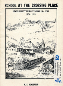
Book, School at the crossing place : Lower Plenty Primary School no. 1295, 1874-1974 / W.F. Henderson, 1974c
... in the Banyule Heritage Study and has recently been restored by Banyule... in the Banyule Heritage Study and has recently been restored by Banyule ...23 pages including information on inside covers. Text with black and white illustrations and photographs and map. Contents: Crossing Place Need for a school Residence for the teacher Closure A View of Lower Plenty 1918 Moving day at the Village The Golf Club Depression 1931 Vandals Electricity Grass Fires Cows at School Mothers' Club Women's liberation 1950's Lower Plenty after 1945 Swimming Pool - drowned dreams Long Grass - snakes - meadow hay - Fire Brigade The Royal Visit 1954 School Band Community Centre Our School Hall Trees and Gardens The Library Education 1874-1974 A Teacher's View The Second generation - children of ex-pupils (photo with names) The Third generation - Grandchildren of ex-pupils (photo with names) Head Teachers (list with dates) The Staff 1974 (photo with names) The sketch on the cover shows the Lower Plenty Bridge, toll house and the Plenty Bridge hotel, both no longer there. The bridge is listed in the Banyule Heritage Study and has recently been restored by Banyule Council as a pedestrian bridge - NL 137 March 2001 Paperback; [24] p. : ill. ; 25 cm.lower plenty, state school no. 1295, lower plenty primary school -
 Glen Eira Historical Society
Letter - Heritage Watch Caulfield
... , The Grand Union Tram Junction, Caulfield Heritage Study... on Rosecraddock, The Grand Union Tram Junction, Caulfield Heritage Study ...This file contains 5 items: 1/Documents related to the establishment of Heritage Watch in Caulfield. This includes a typed letter to Mrs. And Mr. Campbell from Graham Walsh inviting them to attend a meeting concerning the potential establishment of Heritage Watch – dated 08/11/1989. A nomination form to elect a committee –dated 27/06/1991, and documents outlining goals, maps of proposed area designated by the council, and black-and-white photographs of Miners Cottage Elsternwick and a mansion in Ripponlea, Elsternwick. 2/Minutes of Caulfield Heritage Watch Committee meetings on 04/12/1999, 22./01/1990, 08/10/1990 and 26/11/1990. It includes aims, general business, publicity and discussion on ‘Rosecraddock’. 3/Caulfield Heritage Watch Newsletter issue number three dated June 1991. It includes a paragraph on Rosecraddock, The Grand Union Tram Junction, Caulfield Heritage Study and an invitation to the annual general meeting on 27/06/1991. 4/Financial statement for Caulfield Heritage Watch for November 1989 to May 1991. 5/A handwritten submission to save Rosecraddock from demolition, date and author unknown.caulfield train station, margaret street 28, walsh graham a., caulfield manor grove 1, shellard mr., labassa, derby road, inkerman road, kerr paul, glen huntly road, victorian houses, gladstone parade, hawthorn road, o’neill college, miners cottage regent street elsternwick, buildings, heritage, preservation, urban conservation policy, caulfield city council, campbell mr. + mrs., caulfield heritage watch committee, snowball b., kay w., spencer d., dustan don, dustan david, campbell f., hill tess, jordan p., ritchie jack, architecture, development, cultural structures and establishments, residential development, murray, wells, hopkins sherry, caulfield town hall, rodder a., caulfield contact, spiker mr., elsternwick railway, elsternwick club, committees and inquiries, meetings, rosecraddock, construction sites, property, hill l., mayoress’ room caulfield, city hall, morris e., feehan j., molony v., moore mrs., elsternwick sandham street 19, elsternwick bowling club, ward andrew, shellard mr., construction and demolition, balaclava road, tramways, tram junction, kerr paul, gardens, save rosecraddock neighbourhood group -
 Kew Historical Society Inc
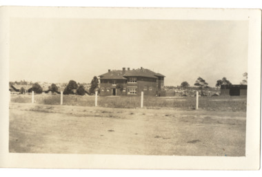
Postcard - Kew East State School No.3161, 35 Kitchener Street, c.1927
... Albert Heritage Gap Study (August 2020) established that: 'Kew... in Kitchener Street in 1923. The Kew East and Mont Albert Heritage Gap ...What is now Kew East Primary School was opened on its current site in Kitchener Street in 1923. The Kew East and Mont Albert Heritage Gap Study (August 2020) established that: 'Kew East Primary School No. 3136 is historically significant for the evidence it provides of an early phase in the development of Kew East which gathered momentum from the 1920s, as housing developed rapidly and the population increased in response to the extension of the High Street tram to Harp Road then Burke Road then improved tram connections between the area and the city.'A rare and early photograph of the school taken four years after its construction. Small, sepia coloured photographic positive of East Kew State School. The two storey red brick building was opened in 1923. This view, three years after its construction shows preliminary fencing and undeveloped playing grounds.schools -- kew east (vic.), government schools -- kew -- kew east, strathalbyn street -
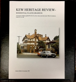
 Kew Historical Society Inc
Archive (Sub-series) - Subject File, Kew Heritage Review, Residential Places Graded B, Volume 1, 1999, 1999
... to commission further conservation studies from a range of heritage... conservation studies from a range of heritage consultants including ...Graeme Butler & AssociatesProject FilesProvenance OrderBlack 4-Ring binder that includes research about, and an assessment of buildings previously graded B in the City of Kew Urban Conservation Study 1988 by Pru Sanderson Design Pty Ltd. The files were created by the heritage architect Graeme Butler and the paper files include maps, correspondence, title searches, readings, reviews of prior classifications, newspaper and journal articles, directories etc for each property assessed.graeme butler, heritage reviews - kew, 20 yarra street, 8 yarra street, 33 wills street, 25 wellington street, 11 wellington street, 118 walpole street, 84 walpole street, 83 walpole street, 63 walpole street, 52 walpole street, 51 walpole street, 14 vista avenue, 12 tara avenue, 89 studley park road, 75 studley park road, 44 studley park road, 25 studley park road, 13 studley avenue, 21 stoke avenue, 71 stevenson street, 34 stevenson street, 12 stevenson street, 36 stawell street, 11 second avenue, 3 second avenue, 2 second avenue, 34 rowland street, 21 redmond street, 11 redmond street, 16 queen street, 27 princess street, 82 molesworth street, 28 miller grove, 26 miller grove, 24 miller grove, 24 milfay avenue, 8 milfay avenue, 4 merrion grove, 25 mary street, 24 lister avenue, 2 john street, 9 hume street, 7 hume street, 24 howard street, 20 howard street, 19 howard street, 10 howard street, 2 howard street, 26 holroyd street, 12 holroyd street, 73 high street, 69 high street, 35 high street, 6 high street, 53 harp road, 6 gellibrand street, 48 foley street, 9 eglinton street, 25-27 edgecombe street, 21-23 edgecombe street, 5-7 edgecombe street, 23 dunlop avenue, 167 derby street, 8 denmark street, 1 denmark street, 2 daracomb avenue, 2 danielle place, 340 cotham road, 294 cotham road, 241 cotham road, 221-229 cotham road, 208 cotham road, 193 cotham road, 180 cotham road, 171 cotham road, 167 cotham road, 161 cotham road, 135-137 cotham road, 46 clyde street, 4 cameron court, 1291 burke road, 1223 burke road, 1205 burke road, 5 bowen street, 35-37 belford road, 389 barkers road, 387 barkers road, 311 barkers road, 231 barkers road, 83-85 barkers road, 15 adeney avenue, 6 a'beckett streetgraeme butler, heritage reviews - kew, 20 yarra street, 8 yarra street, 33 wills street, 25 wellington street, 11 wellington street, 118 walpole street, 84 walpole street, 83 walpole street, 63 walpole street, 52 walpole street, 51 walpole street, 14 vista avenue, 12 tara avenue, 89 studley park road, 75 studley park road, 44 studley park road, 25 studley park road, 13 studley avenue, 21 stoke avenue, 71 stevenson street, 34 stevenson street, 12 stevenson street, 36 stawell street, 11 second avenue, 3 second avenue, 2 second avenue, 34 rowland street, 21 redmond street, 11 redmond street, 16 queen street, 27 princess street, 82 molesworth street, 28 miller grove, 26 miller grove, 24 miller grove, 24 milfay avenue, 8 milfay avenue, 4 merrion grove, 25 mary street, 24 lister avenue, 2 john street, 9 hume street, 7 hume street, 24 howard street, 20 howard street, 19 howard street, 10 howard street, 2 howard street, 26 holroyd street, 12 holroyd street, 73 high street, 69 high street, 35 high street, 6 high street, 53 harp road, 6 gellibrand street, 48 foley street, 9 eglinton street, 25-27 edgecombe street, 21-23 edgecombe street, 5-7 edgecombe street, 23 dunlop avenue, 167 derby street, 8 denmark street, 1 denmark street, 2 daracomb avenue, 2 danielle place, 340 cotham road, 294 cotham road, 241 cotham road, 221-229 cotham road, 208 cotham road, 193 cotham road, 180 cotham road, 171 cotham road, 167 cotham road, 161 cotham road, 135-137 cotham road, 46 clyde street, 4 cameron court, 1291 burke road, 1223 burke road, 1205 burke road, 5 bowen street, 35-37 belford road, 389 barkers road, 387 barkers road, 311 barkers road, 231 barkers road, 83-85 barkers road, 15 adeney avenue, 6 a'beckett street -
 Kew Historical Society Inc
Photograph - Photographs, Former Baptist Church, Woodlands Avenue, Kew East, 2018, 2018
... of the Kew East Heritage Gap Study. W D Vaughan in his 'Kew's Civic... Heritage Gap Study. W D Vaughan in his 'Kew's Civic History' (1960 ...The former Baptist Church, at 8-12 Woodlands Avenue, Kew East, was nominated by the Society for protection as part of the Kew East Heritage Gap Study. W D Vaughan in his 'Kew's Civic History' (1960 writes that: "With the development of East Kew, local Baptists considered the establishment of a church was necessary. A block of land was purchased in Woodlands Avenue and the foundation stone of a new church was laid on August 8, 1931. A fine Sunday school has since been erected, and special emphasis has been given to providing activities for the young people of the church"Three colour photographs of the former Baptist Church in Woodlands Avenue, Kew East. The photographs are of the front and side of the clinker brick building. One of the photographs shows the foundation stone, laid by AH Lewis Esq, 8 August 1931.churches - kew (vic), baptist church - woodlands avenue - kew (vic) -
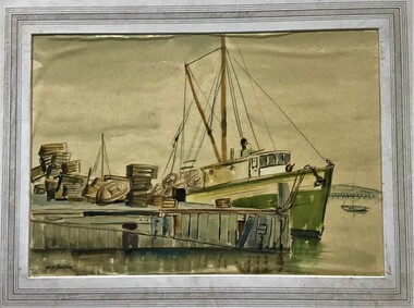 Queenscliffe Maritime Museum
Painting - Framed Watercolour, Fishermen's Pier Queenscliff
... . ‘Individual Property Citation’, Queenscliffe Heritage Study, 2009...’, Queenscliffe Heritage Study, 2009.) (Freya Mitchell, ‘Queenscliff ...Queenscliff’s first pier, then known as the Fishermen’s Pier, was completed in 1857. It was not until some thirty years later that the second Steamer Pier was constructed adjacent to the former and periodically extended from the mid to late 1880s to cope with the demand in pleasure bay steamer services. The last of these extensions was to provide a dog-leg construction and the extant shelter shed. 1960 witnessed the demolition of the original Fishermen’s Pier - by this time having been extended in the late nineteenth and early twentieth centuries to the equivalent length of the Steamer Pier - and saw the relocation of its 1926-29 lifeboat house to the Steamer Pier, now Queenscliff Pier. The mid to late 2000s saw Queenscliff Harbour undergo large-scale redevelopment in order to deepen its waters for pleasure craft and increase its berths to over 300. This was met with strong community opposition, largely with concerns for neighbourhood character and perceived cause for gentrification its stakeholders would impart. With early construction estimates of $20 million dollars, this figure had almost doubled upon realisation. (Lovell Chen Architects. ‘Individual Property Citation’, Queenscliffe Heritage Study, 2009.) (Freya Mitchell, ‘Queenscliff residents fight a tide of development sweeping the historic town’ ABC radio, 15 April 2005).Fishermen's Pier Watercolour painting of Fishermen's Pier in Queenscliffwatercolour, fishermen's pier, queenscliff -
Glen Eira Historical Society
Document - Hengar, Glen Eira Road, 356, Elsternwick
... features and a statement of its heritage significance. The study... Conservation Study by Andrew Ward, dated 01/1995, on Hengar at 356 Glen ...A photocopy of a two page Caulfield Conservation Study by Andrew Ward, dated 01/1995, on Hengar at 356 Glen Eira Road, Elsternwick. The study gives a brief history of Hengar’s construction and occupancy, a description of its Gothic revival architectural features and a statement of its heritage significance. The study includes a black and white photograph of the exterior of Hengar.langdon henry, renwick mary, langdon elizabeth, langdon laura, blanche street, glen eira road, kooyong road, langdon estate, elsternwick, caulfield, hengar, beemery park, rosecraddock, tarqua, beemery, happy days kindergarten, architectural styles, architectural features, gothic revival, victorian style, preschools, the contemporary school of art -
 Ballarat Heritage Services
Photograph - Photograph - Colour, Clare Gervasoni, Koroit Post Office, 2015, 21/12/2015
... Mason of Port Fairy. (Moyne Shire Heritage Study 2006 Stage 2... and engineer John Mason of Port Fairy. (Moyne Shire Heritage Study 2006 ...The town borrows its name from the Koroitch Gundidj people who occupied the area prior to European settlement. (https://en.wikipedia.org/wiki/Koroit, accessed 21 December 2016) Koroit was first surveyed as a township in 1847. Around the 1850 the district had the highest population of Irish immigrants in rural Australia. The Koroit Post Office was designed by architect and engineer John Mason of Port Fairy. (Moyne Shire Heritage Study 2006 Stage 2, Volume 2: Environmental History, Prepared for Moyne Shire Council Helen Doyle in association with Context Pty Ltd, 2006.) Rosebrook Bridge, Rosebrook (1853; replaced) Post Office buildings, Bank Street, Port Fairy (c.1857) The author Henry Handel Richardson lived in the Koroit Post Office as a child after her family moved to Koroit in 1878. Remembering Koroit from her youth, the third volume in her The Fortunes of Richard Mahony trilogy is set in the town. When the author was six, her father Walter died in Koroit on 1 August 1879 and was buried at the Koroit cemetery. (https://en.wikipedia.org/wiki/Koroit, accessed 21 December 2016) In 1878 Mary Richardson was appointed postmistress of the Koroit Post Office at a salary of 72 pounds with free quarters, firewood and kerosene. She lived at the back of the Post Office. (From a Green and Pleasant Land by H. McCorkell and P. Yule.) Photographs showing the bluestone Koroit Post Office, phone box and postbox. It is located at 99 Commercial Road, Koroit. "Historic Area Statement of Significance: The significance of Koroit derives from its role as the urban centre of one of the most concentrated Irish Roman Catholic rural districts in Australia, noted for its mixed livestock and cropping argicultural patterns. This is reflected in two separate and distinctive areas in the town - the administrative/commercial area and the church precinct. The administrative and commercial area (focussing on the Boundary-Commercial Road/High Street intersection and the Koroit Hotel) consists of a number of significant public buildings and leads to a street of relatively intact humble shopfronts and kerbline verandahs, visually punctuated by opposing bank facades. The church precinct is dominated by a group of Catholic buildings larger in scale and more complete in range than those in any comparably sized Victorian town." http://vhd.heritagecouncil.vic.gov.au/places/69338#sthash.ELLuSMvg.dpuf, accessed 21 December 2016."koroit, post office, phone box, payphone, bluestone, henry handel richardson, koroit post office -
 Kew Historical Society Inc
Archive (Sub-series) - Subject File, Kew Heritage Review, Residential Places Graded B, Volume 2, 1999, 1999
... to commission further conservation studies from a range of heritage... conservation studies from a range of heritage consultants including ...Graeme Butler & AssociatesProject FilesProvenance OrderBlack 4-Ring binder that includes research about, and an assessment of buildings previously graded B in the City of Kew Urban Conservation Study 1988 by Pru Sanderson Design Pty Ltd. The files were created by the heritage architect Graeme Butler and the paper files include maps, correspondence, title searches, readings, reviews of prior classifications, newspaper and journal articles, directories etc for each property assessed. graeme butler, heritage reviews - kew, 25 mary street, 4 merrion grove, 24 milfay avenue, 24 miller grove, 26 miller grove, 28 miller grove, 82 molesworth street, 27 princess street, 16 queen street, 20 yarra street, 84 walpole street, 118 walpole street, 11 wellington street, 83 walpole street, 25 wellington street, 8 yarra street, 33 wills street, 63 walpole street, 14 vista avenue, 89 studley park road, 12 tara avenue, 75 studley park road, 21 redmond street, 52 walpole street, 51 walpole street, 71 stevenson street, 34 rowland street, 21 stoke avenue, 34 stevenson street, 44 studley park road, 25 studley park road, 13 studley avenue, 2 second avenue, 11 second avenue, 3 second avenue, 36 stawell street, 12 stevenson streetgraeme butler, heritage reviews - kew, 25 mary street, 4 merrion grove, 24 milfay avenue, 24 miller grove, 26 miller grove, 28 miller grove, 82 molesworth street, 27 princess street, 16 queen street, 20 yarra street, 84 walpole street, 118 walpole street, 11 wellington street, 83 walpole street, 25 wellington street, 8 yarra street, 33 wills street, 63 walpole street, 14 vista avenue, 89 studley park road, 12 tara avenue, 75 studley park road, 21 redmond street, 52 walpole street, 51 walpole street, 71 stevenson street, 34 rowland street, 21 stoke avenue, 34 stevenson street, 44 studley park road, 25 studley park road, 13 studley avenue, 2 second avenue, 11 second avenue, 3 second avenue, 36 stawell street, 12 stevenson street -
 Kew Historical Society Inc
Archive (Sub-series) - Subject File, Kew Heritage Review, Residential Places Graded B, Volume 3, 1999, 1999
... to commission further conservation studies from a range of heritage... conservation studies from a range of heritage consultants including ...Graeme Butler & AssociatesProject FilesProvenance OrderBlack 4-Ring binder that includes research about, and an assessment of buildings previously graded B in the City of Kew Urban Conservation Study 1988 by Pru Sanderson Design Pty Ltd. The files were created by the heritage architect Graeme Butler and the paper files include maps, correspondence, title searches, readings, reviews of prior classifications, newspaper and journal articles, directories etc for each property assessed.graeme butler, heritage reviews - kew, 4 cameron court, 2 hodgson street, 20 fellows street, 26 fellows street, 23 highbury grove, kew lunatic asylum, kew mental hospital, willsmere, 36 stawell street, 13 studley avenue, 16 studley avenue, 20 studley avenue, raheen, studley park road, beament house, 33 uvadale road, 20 yarra streetgraeme butler, heritage reviews - kew, 4 cameron court, 2 hodgson street, 20 fellows street, 26 fellows street, 23 highbury grove, kew lunatic asylum, kew mental hospital, willsmere, 36 stawell street, 13 studley avenue, 16 studley avenue, 20 studley avenue, raheen, studley park road, beament house, 33 uvadale road, 20 yarra street -
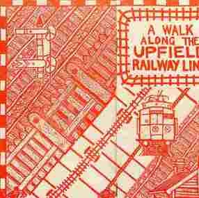 Brunswick Community History Group
Archive - Upfield Railway Line
... Heritage Study by Andrew Ward (1990) can be found on the Merri-bek... Heritage Study by Andrew Ward (1990) can be found on the Merri-bek ...Our collection includes a number of documents on the history of the line including a film Heritage on the Line produced in 1992 and Down the line to Upfield by Jon Saul and Wendy Moore. 3rd edition 1994 and Northern Suburbs Transport Plan prepared by the Upgrade Upfield Coordinating Committee 1994. / The Upfield Line Heritage Study by Andrew Ward (1990) can be found on the Merri-bek Council website. / The Lonie Report prepared by the State Government in 1988 recommended conversion of all or part of the line to light rail. Some proposals involved replacing the Sydney Road trams with light rail, freeing up the rail reservation for a freeway, while others proposed installing the light rail on the rail reservation from Upfield to Park Street, where the line would divert to join the Royal Parade tram line. / Our collection includes documents on the community campaign to save the line from the Cain Government in 1989-90 and the Kennett Government in 1992-93. The Save the Upfield Line Campaign was set up and composed of local residents. We have a collection of their minutes and campaign materials. Brunswick Council was also actively involved in campaigning to save the line and set a Council and community committee to work on this. We also have minutes of its meetings and some Council reports on the issue. / In 1995 the State Government finally agreed to retain and upgrade the line. Document file"rail services, upfield railway line, community campaigns" -
 Bacchus Marsh & District Historical Society
Photograph, Trinity Church Bacchus Marsh (The Iron Church)
... the remnants were described by Peterson and Catrice in the Heritage... the remnants were described by Peterson and Catrice in the Heritage ...Anglican (Church of England) services began in Bacchus Marsh as early as the 1840s. In 1855 an imported iron building from England became the first permanent Anglican Church building in Bacchus Marsh. It stood close to the location of the Holy Trinity Anglican Church erected in 1877 which still stands in 2025. It was in use between 1855 and 1877. These type of iron structures were cheaper to erect and could be dismantled and moved to other locations when necessary. The Iron Church was brick-lined and could hold between 150 and 200 people. The Church was opened on 4 July 1855 by Hussey Burgh Macartney, Dean of Melbourne. It was later consecrated by Bishop Perry on 28 July, 1861. The cost of construction was around 1,000 pounds. In 1877 the Holy Trinity Church was erected. The Iron Church was dismantled and sold to to two local businessmen, George Marshall and James Reid. It was re-erected in July 1877 without its brick lining or steeple and is presumed to have been used as a shed at a location in Graham Street known as 'Webster's Brothers Yard', (14 Graham Street). Over time the structure deteriorated to the point that it could no longer be used. Remnants of the Iron Church could be seen for many years. In 1995 the remnants were described by Peterson and Catrice in the Heritage Study of Bacchus Marsh Shire in the this way, 'on the rear boundary, now used as an outbuilding, is the surviving fabric of the former "Iron Church". This has a gabled roof and had four pointed windows at sides. It is all clad in corrugated iron. Access was not possible, but a 1977 photograph shows Gothic tracery in a window'. This is a rare image of a prefabricated building in mid-nineteenth century Victoria. Prefabricated buildings were widely used in the early Colonial period of Victoria as a cheaper building option for new and developing communities. Most of these buildings did not survive in the long term and photographic evidence of these type of structures is an important record of an aspect of Victoria's architectural history.Small black and white 'carte de viste' style photograph mounted on card. The image depicts the first permanent Anglican Church building in Bacchus Marsh, the Trinity Church, also known as the Iron Church. The date of the image is thought to be about 1867.anglican church bacchus marsh, churches bacchus marsh, trinity church bacchus marsh, bacchus marsh iron church, prefabricated buildings -
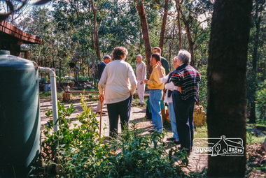
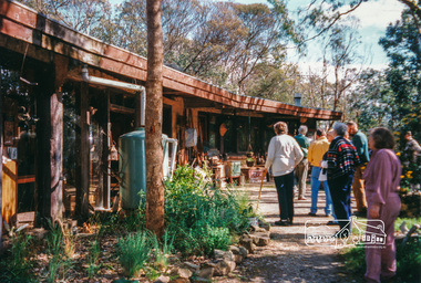
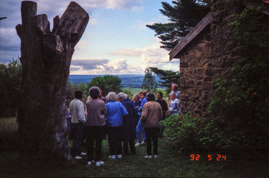
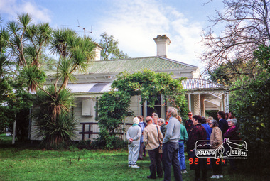
 Eltham District Historical Society Inc
Photograph, Allwood House, Hurstbridge, Eltham Heritage Tour, 24 May 1992, 24/05/1992
... heritage study. David selected a number of sites or buildings... out the Shire's heritage study. David selected a number ...ELTHAM HERITAGE TOUR The Society excursion on 24th May 1992 was arranged by David Bick, leader of the team carrying out the Shire's heritage study. David selected a number of sites or buildings identified in the study, some of them lesser known components of the Shire's heritage. The tour commenced at the Eltham Shire Office at 10.00 am. Travel was by private car and mini-bus with stops at about twelve locations for commentary by David.It included a short walk in Hurstbridge and lunch at Kinglake. Highlights of the tour included: - 10 am Leave from Shire Offices - 3 Important Trees - A Physical Link to Eltham's First Settlers - Toorak Mansion Gates - A Surviving Farm House - An Intact Circa 1900 Main Street - First Settlers - Gold Miners, and Timber-getters - An Early Hotel - A Pioneering Homestead - Changing Eltham Shire - 20th Century - 4 pm Afternoon Tea and Finish Tour Extract from ELTHAM CULTURAL HERITAGE TOUR (Newsletter No. 85, July 1992, by Bettina Woodburn) "At the crossroads stands Allwood House with its well laid out garden. The original owners, the Hurst family, ran a nursery; the aligned palms, the cactus clumps, the introduced trees and shrubs show the plants then in fashion. On the other corners stand an old corrugated iron garage; a restaurant, designed and built 1980, but by using old materials it tries to retain the rustic character of its surroundings; and open space where a two storied Wineshop/Saloon once stood. The old Bank, now in the grounds of Allwood House has been moved a few doors down the street."Record of the Society's history and activities and highlighting various aspects of the Heritage Study undertaken by David Bick used to create the future heritage overlay for the Shire of Eltham and later Nillumbik Shire.Roll of 35mm colour negative film, 4 stripsKodak Gold 100 5095shire of eltham historical society, activities, heritage tour, hurstbridge, allwood house -
 Eltham District Historical Society Inc
Photograph, Kangaroo Ground War Memorial, Eltham Heritage Tour, 24 May 1992, 24/05/1992
... heritage study. David selected a number of sites or buildings... out the Shire's heritage study. David selected a number ...ELTHAM HERITAGE TOUR The Society excursion on 24th May 1992 was arranged by David Bick, leader of the team carrying out the Shire's heritage study. David selected a number of sites or buildings identified in the study, some of them lesser known components of the Shire's heritage. The tour commenced at the Eltham Shire Office at 10.00 am. Travel was by private car and mini-bus with stops at about twelve locations for commentary by David.It included a short walk in Hurstbridge and lunch at Kinglake. Highlights of the tour included: - 10 am Leave from Shire Offices - 3 Important Trees - A Physical Link to Eltham's First Settlers - Toorak Mansion Gates - A Surviving Farm House - An Intact Circa 1900 Main Street - First Settlers - Gold Miners, and Timber-getters - An Early Hotel - A Pioneering Homestead - Changing Eltham Shire - 20th Century - 4 pm Afternoon Tea and Finish Tour Extract from ELTHAM CULTURAL HERITAGE TOUR (Newsletter No. 85, July 1992, by Bettina Woodburn) "Now we drove through stands of pines to the Kangaroo Ground Lookout Tower, a most unusual War Memorial, World War I. The tower and a shed/residence (it had a chimney) were built from local sandstone. Below to the south and east of Melbourne spread 'suburbia'. Close by the landscape seemed so contrived - English fields and hedgerows! Although only about twenty inches deep, the soil of this ancient volcano, its crater lost under subsequent weathering, was rich, deserving the name of "Garden Hill". Now native trees are taking over again. In Kangaroo Ground itself stand the inevitable Store, School and Church - and two Norfolk pines and a monkey puzzle tree."Record of the Society's history and activities and highlighting various aspects of the Heritage Study undertaken by David Bick used to create the future heritage overlay for the Shire of Eltham and later Nillumbik Shire.Roll of 35mm colour negative film, 4 stripsKodak Gold 100 5095shire of eltham historical society, activities, heritage tour, kangaroo ground, kangaroo ground tower, war memorials, kangaroo ground memorial -
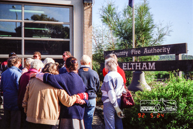 Eltham District Historical Society Inc
Photograph, Eltham Fire Station, Main Road, Eltham Heritage Tour, 24 May 1992, 24/05/1992
... heritage study. David selected a number of sites or buildings... out the Shire's heritage study. David selected a number ...ELTHAM HERITAGE TOUR The Society excursion on 24th May 1992 was arranged by David Bick, leader of the team carrying out the Shire's heritage study. David selected a number of sites or buildings identified in the study, some of them lesser known components of the Shire's heritage. The tour commenced at the Eltham Shire Office at 10.00 am. Travel was by private car and mini-bus with stops at about twelve locations for commentary by David.It included a short walk in Hurstbridge and lunch at Kinglake. Highlights of the tour included: - 10 am Leave from Shire Offices - 3 Important Trees - A Physical Link to Eltham's First Settlers - Toorak Mansion Gates - A Surviving Farm House - An Intact Circa 1900 Main Street - First Settlers - Gold Miners, and Timber-getters - An Early Hotel - A Pioneering Homestead - Changing Eltham Shire - 20th Century - 4 pm Afternoon Tea and Finish Tour Extract from ELTHAM CULTURAL HERITAGE TOUR (Newsletter No. 85, July 1992, by Bettina Woodburn) "Commencing with a quick walk to see the magnificent bell at the Eltham Fire Station, we then 'drove along Arthur Street. Here were examples of what constitutes the building environment of Eltham. Massed among the wattles and eucalypts were golden cypress and pines; No. 50 was an exotic 'old English' manor-house; No. 93 had bluestone gateposts, from Fenton Road Toorak (as with Montsalvat, using re-cycled building material was very much the trend); past the natural Reserve dedicated to the artist Walter Withers, a plaque on a huge boulder; and on both sides houses in the various modes - timber with wrought iron decor, brick-some more recent than others, decades of 'suburbia'."Record of the Society's history and activities and highlighting various aspects of the Heritage Study undertaken by David Bick used to create the future heritage overlay for the Shire of Eltham and later Nillumbik Shire.Roll of 35mm colour negative film, 4 stripsKodak Gold 100 5095eltham, main road, shire of eltham historical society, activities, heritage tour, cfa -
 Eltham District Historical Society Inc
Photograph, Allwood House, Hurstbridge, Eltham Heritage Tour, 24 May 1992, 24/05/1992
... heritage study. David selected a number of sites or buildings... out the Shire's heritage study. David selected a number ...ELTHAM HERITAGE TOUR The Society excursion on 24th May 1992 was arranged by David Bick, leader of the team carrying out the Shire's heritage study. David selected a number of sites or buildings identified in the study, some of them lesser known components of the Shire's heritage. The tour commenced at the Eltham Shire Office at 10.00 am. Travel was by private car and mini-bus with stops at about twelve locations for commentary by David.It included a short walk in Hurstbridge and lunch at Kinglake. Highlights of the tour included: - 10 am Leave from Shire Offices - 3 Important Trees - A Physical Link to Eltham's First Settlers - Toorak Mansion Gates - A Surviving Farm House - An Intact Circa 1900 Main Street - First Settlers - Gold Miners, and Timber-getters - An Early Hotel - A Pioneering Homestead - Changing Eltham Shire - 20th Century - 4 pm Afternoon Tea and Finish Tour Extract from ELTHAM CULTURAL HERITAGE TOUR (Newsletter No. 85, July 1992, by Bettina Woodburn) "At the crossroads stands Allwood House with its well laid out garden. The original owners, the Hurst family, ran a nursery; the aligned palms, the cactus clumps, the introduced trees and shrubs show the plants then in fashion. On the other corners stand an old corrugated iron garage; a restaurant, designed and built 1980, but by using old materials it tries to retain the rustic character of its surroundings; and open space where a two storied Wineshop/Saloon once stood. The old Bank, now in the grounds of Allwood House has been moved a few doors down the street."Record of the Society's history and activities and highlighting various aspects of the Heritage Study undertaken by David Bick used to create the future heritage overlay for the Shire of Eltham and later Nillumbik Shire.Roll of 35mm colour negative film, 4 stripsKodak Gold 100 5095shire of eltham historical society, activities, heritage tour, hurstbridge, allwood house -
 Eltham District Historical Society Inc
Photograph, Kangaroo Ground War Memorial, Eltham Heritage Tour, 24 May 1992, 24/05/1992
... heritage study. David selected a number of sites or buildings... out the Shire's heritage study. David selected a number ...ELTHAM HERITAGE TOUR The Society excursion on 24th May 1992 was arranged by David Bick, leader of the team carrying out the Shire's heritage study. David selected a number of sites or buildings identified in the study, some of them lesser known components of the Shire's heritage. The tour commenced at the Eltham Shire Office at 10.00 am. Travel was by private car and mini-bus with stops at about twelve locations for commentary by David.It included a short walk in Hurstbridge and lunch at Kinglake. Highlights of the tour included: - 10 am Leave from Shire Offices - 3 Important Trees - A Physical Link to Eltham's First Settlers - Toorak Mansion Gates - A Surviving Farm House - An Intact Circa 1900 Main Street - First Settlers - Gold Miners, and Timber-getters - An Early Hotel - A Pioneering Homestead - Changing Eltham Shire - 20th Century - 4 pm Afternoon Tea and Finish Tour Extract from ELTHAM CULTURAL HERITAGE TOUR (Newsletter No. 85, July 1992, by Bettina Woodburn) "Now we drove through stands of pines to the Kangaroo Ground Lookout Tower, a most unusual War Memorial, World War I. The tower and a shed/residence (it had a chimney) were built from local sandstone. Below to the south and east of Melbourne spread 'suburbia'. Close by the landscape seemed so contrived - English fields and hedgerows! Although only about twenty inches deep, the soil of this ancient volcano, its crater lost under subsequent weathering, was rich, deserving the name of "Garden Hill". Now native trees are taking over again. In Kangaroo Ground itself stand the inevitable Store, School and Church - and two Norfolk pines and a monkey puzzle tree."Record of the Society's history and activities and highlighting various aspects of the Heritage Study undertaken by David Bick used to create the future heritage overlay for the Shire of Eltham and later Nillumbik Shire.Roll of 35mm colour negative film, 4 stripsKodak Gold 100 5095shire of eltham historical society, activities, heritage tour, kangaroo ground, kangaroo ground tower, war memorials, kangaroo ground memorial -
 Eltham District Historical Society Inc
Photograph, Hurstbridge shops, Heidelberg-Kinglake Road, opposite Hurstbridge Railway Station, Eltham Heritage Tour, 24 May 1992, 24/05/1992
... heritage study. David selected a number of sites or buildings... out the Shire's heritage study. David selected a number ...ELTHAM HERITAGE TOUR The Society excursion on 24th May 1992 was arranged by David Bick, leader of the team carrying out the Shire's heritage study. David selected a number of sites or buildings identified in the study, some of them lesser known components of the Shire's heritage. The tour commenced at the Eltham Shire Office at 10.00 am. Travel was by private car and mini-bus with stops at about twelve locations for commentary by David.It included a short walk in Hurstbridge and lunch at Kinglake. Highlights of the tour included: - 10 am Leave from Shire Offices - 3 Important Trees - A Physical Link to Eltham's First Settlers - Toorak Mansion Gates - A Surviving Farm House - An Intact Circa 1900 Main Street - First Settlers - Gold Miners, and Timber-getters - An Early Hotel - A Pioneering Homestead - Changing Eltham Shire - 20th Century - 4 pm Afternoon Tea and Finish Tour Extract from ELTHAM CULTURAL HERITAGE TOUR (Newsletter No. 85, July 1992, by Bettina Woodburn) "Leaving the cars at Hurstbridge we walked the main street of the old village settlement, now a suburb. Near the station was a fine Edwardian house complete with palm and pines. Opposite was the Police Station, 1930-60 with a portable lock-up behind and the residence beside it. No. 794 was the Post Off1ce 3099 the-original shop-front window now has mail-boxes below. Close to the Railway entrance the butcher's shop remains unchanged, but across the road the linear shopping centre tries to keep the character of the olden times. The Fire Bell once hung on a tall gum outside No. 832. Palms in front gardens indicate the age of some of the homes, about 70 years. A corrugated iron shed still stands on the front fence line next to No. 840. Adding to the streetscape is an example of the standard timber early 20th century four veranda post suburban villa."Record of the Society's history and activities and highlighting various aspects of the Heritage Study undertaken by David Bick used to create the future heritage overlay for the Shire of Eltham and later Nillumbik Shire.Roll of 35mm colour negative film, 4 stripsKodak Gold 100 5095shire of eltham historical society, activities, heritage tour, hurstbridge, shops