Showing 197 items
matching map of germany
-
 Mrs Aeneas Gunn Memorial Library
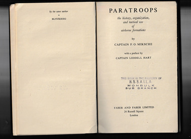
Book, Faber and Faber, Paratroops, 1943
A technical description of the tactics of ParatroopsIll, maps, p.263.non-fictionA technical description of the tactics of Paratroopsparatroops - tactics, partroops - germany -
 Mrs Aeneas Gunn Memorial Library
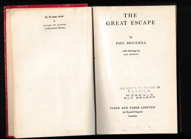
Book - The Great Escape, Faber & Faber, 1951
... , drew maps, faked weapons, and tailored german uniforms ...With only their bare hands and the crudest of homemade tools, they sank shafts, built underground railroads, forged passports, drew maps, faked weapons, and tailored german uniforms and civilian clothes. They developed a fantastic security system to protect themselves from the German "ferrets" who prowled the compounds with nerve-racking tenacity and suspicion. It was a split-second operation as delicate and as deadly as a time bomb.Ill, p.263.non-fictionWith only their bare hands and the crudest of homemade tools, they sank shafts, built underground railroads, forged passports, drew maps, faked weapons, and tailored german uniforms and civilian clothes. They developed a fantastic security system to protect themselves from the German "ferrets" who prowled the compounds with nerve-racking tenacity and suspicion. It was a split-second operation as delicate and as deadly as a time bomb. world war 1939-1945 - prisoners of war, world war 1939 1945 - escapes -
 Mrs Aeneas Gunn Memorial Library
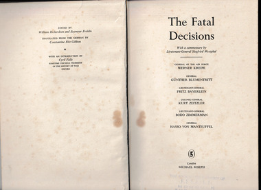
Book, Michael Joseph, The fatal decisions, 1956
Analysis of six decisive battles fought by the German armed forces in World War Two as described by the generals involved.Index, ill, maps, p.261.non-fictionAnalysis of six decisive battles fought by the German armed forces in World War Two as described by the generals involved.world war 1939-1945 - campaigns - germany, germany - history - military -
 Mont De Lancey
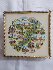
Decorative object - German Wall Tile, Wessel, Unknown
This tile has been made into a wall hanging by the attachment of fine wire at top to two of the curled feet.A small Wessel decorative white ceramic tile or trivet with a white porcelain type top depicting a coloured map of the Mosel River and surrounding towns in Germany. There is a twisted thin gold frame around it with rounded feet in the corners.On the front at the top of the tile is written - 'Die Mosel von KOBLENZ bis TRIER'. On the back is the manufacturer's stamp in raised letters 'Wessel Made in Germany with a crown on top of it'. There is a number '9, 6 tiny dots, K6 2 more dots, 5'tiles, wall tiles, decorative tiles -
 Mrs Aeneas Gunn Memorial Library
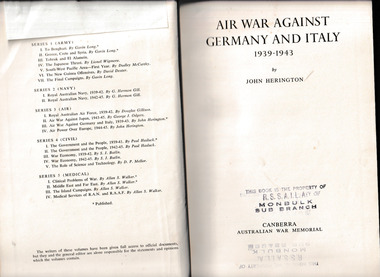
Book, Australian War Memorial, Air war against Germany and Italy, 1939-1943, 1952
The RAAF in Europe between 1939 and 1943Index, ill, maps, p.700.non-fictionThe RAAF in Europe between 1939 and 1943world war 1939-1945 - australia, world war 1939-1945 - aerial operations - australia -
 Mrs Aeneas Gunn Memorial Library
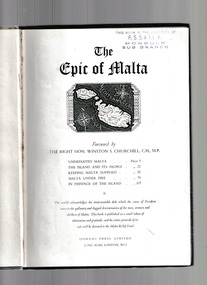
Book, Odhams Press, The epic of Malta, 1946?
The defence of Malta during World war TwoIll, maps, p.128.non-fictionThe defence of Malta during World war Twomalta - history - 1941-1942, malta - aerial operations - germany -
 Tatura Irrigation & Wartime Camps Museum
Booklet - Booklet - Text Book, Reugeltaltung von Recht Birtlchalt
... language Maps German Territories' Published 1942 Book, card cover ...German text book from camp 13Book, card cover with paper pages. Tan in colour, top of front cover has blue background with tan letters. Back cover tan with blue writing on back page. All writing in Germancamp 13, text book, german language, maps german territories', published 1942 -
 Whitehorse Historical Society Inc.
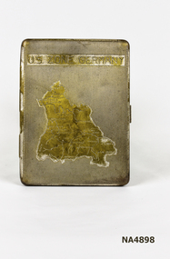
Container - Cigarette Case, 1940's
... PERSONAL EFFECTS Smoking Accessories U.S. Zone of Germany ...Metal cigarette case. Map on front shows the U.S. Occupied Zone of Germany in the post war years.|Perhaps issued or sold to the U.S. Forces. There is a clip inside to hold cigarettes.U.S. Zone of Germanypersonal effects, smoking accessories -
 The Beechworth Burke Museum
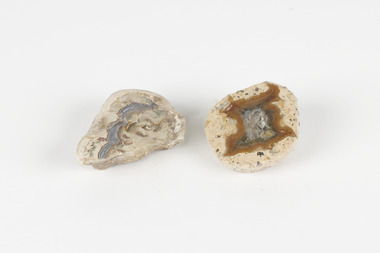
Geological specimen - Thunderegg agates, Unknown
Thunderegg Agates are formed within rhyolite volcanic ash layers. They are rough spherical shapes, varying in size from less than an inch to over a metre long. Thundereggs usually contain centres of chalcedony which may have been fractured followed by deposition of agate, jasper or opal, either uniquely or in combination. A unique characteristic that these specimens have is the fact that they often look like ordinary rocks on the outside, but slicing them in half and polishing them may reveal intricate patterns and colours. These particular specimens are examples of thunderegg agates. Agate is a variety of chalcedony, a cryptocrystalline form of quartz. The agate component contributes to the intriguing internal patterns of the specimens. The specific locality of these specimens is unknown but they can be found in flows of rhyolite lava. They are formed in gas pockets in the lava, which act as moulds. These specimens can be found globally, with specific locations in Germany being particularly abundant. This specimen is part of a larger collection of geological and mineral specimens collected from around Australia (and some parts of the world) and donated to the Burke Museum between 1868-1880. A large percentage of these specimens were collected in Victoria as part of the Geological Survey of Victoria that begun in 1852 (in response to the Gold Rush) to study and map the geology of Victoria. Collecting geological specimens was an important part of mapping and understanding the scientific makeup of the earth. Many of these specimens were sent to research and collecting organisations across Australia, including the Burke Museum, to educate and encourage further study.Two small solid specimens with pale, sandy-coloured exteriors and fractured internal patterns. burke museum, beechworth, geological, geological specimen, thundereggs, thundereggs agate, agate, rhyolite, rhyolite lava, volcanic ash, chalcedony, cryptocrystalline -
Bendigo Historical Society Inc.
Document - SPECIMEN COTTAGE COLLECTION: VARIOUS DOCUMENTS
Various documents in plastic folders. The topics are: 4030.1 – 4300.25 Various documents in plastic folders. Various documents in plastic folders. The topics are: 4030.1 Photocopy of an article titled Saunders' Victoria House. Also a map of the Saunders residence in High Street. 4030.2. Article titled What I saw in gaol July 1889 (written by Gilbert Rule.. 4030.3. Eleven pages essay: H. M. Prison Bendigo after a short history of the prison there are details of several criminal cases. Also brochure H.M. Prison Bendigo 1861-2006, Official decommissioning ceremony 5 January 2006. 4030.4. The Temple Builders, talk by Alex H. Stone 10th May, 1998. 4030.5. The German contribution to early Bendigo by Frank Cusack. 4030.6. Children's games played during and prior to the great depression, Interviews conducted by James Lerk. People interviewed are: Stella Banfield, Mary Pickles, Geoff Newman, Vel Newman, Joan O'Donahue, Peg Schlotterlein, James Gallagher, Jack Larkin, Ken Maes. 4030.7. Email from Hans Tracksdorf to Andy Walker and Ana Hilson updating on the Charlton Building at 60-62 Mundy Street, June 2015, several coloured photos attached. 4030.8. Notes on the family of Elizabeth Ann Butler. 4030.9. The Amy Castles story, a narrative on the life of the singer Amy Castles. Also a booklet ''I lived for the art'' The story of Amy Castles concert program. 4030.10. Harcourt Valley Heritage & Tourist Centre ''Granite houses of Faraday and Harcourt'' by George Milford, March 2010. 4030.11. The story of Knipe's castle and the man who built it, John Hanlon Knipe. A paper presented by Mrs. Edith Lunn 2nd April, 1987. Also some photographs of graves and various documents. 4030.12. Report: Victorian Heritage database place details 15/07/2014 former Kahland winery and cellars. Also two coloured photographs from Tony Robinson' s walk around Bendigo, Kahland street - Lynden house built 1873 wine cellar. 4030.13. several letters from James and Dinah Jeal to their parents detailing their travels on the goldfields dates from 1855 to 1865. 4030.14. Photocopy of a six pages hand written letter to a Walter Edis (?. in England from a J. Wharton (?. from Woodstock on Loddon, detailing his boat trip to Melbourne and the train trip to Marong where he is working. Letter dated July 9th, 1923. 4030.15. The history of T.C. Watts & Son, real estate agents in Bendigo by Edith Lunn. September 30th, 2000. 4030.16. Medals created by Messrs Joseph and Co. Pall Mall, Sandhurst and Melbourne with special reference to ''Champion Medals'' created for the Bendigo Rifles and other Victorian forces. 1858 to 1885. Compiled by Angus Pearson December 2012. 4030.17. Talk by Jim Evans at September 202 meeting of the Bendigo Historical Society. The Inimitable Charles Thatcher, colonial minstrel. 4030.18. Six pages typewritten document titled: C.R. Thatcher, the local songster. Date and author unknown. 4030.19. Music sheet. The Chinaman. Thatcher's colonial songs as written and sung by Charles Robert Thatcher during the goldrushes in the Shamrock hotel, Bendigo. 4030.20. Heidi Teague young historian award two pages detailing the criteria for the award, a newspaper obituary for Heidi Teague and a twenty five pages transcribe interview of Heidi Teague, Heidi was interviewed by Ines Tyson and transcribed by Carol Woolman in 2009. 4030.21. Photograph of Richard Bertram Taylor in military uniform, Richard was killed in action in WWI. Also a brief family history 4030.22. Six pages typewritten letter from John Stuart, Assistant Surgeon Royal Navy to chief Secretary The Honourable C. Haines dated Sandhurst 27th May, 1857 regarding Chinese protectorate. 4030.23. Eight pages biography with photos of Sister Clara Stewart. 4030.24. Two pages biography on John Boyd Watson (and sons. by Rob Upson 4030.25. History of Alick Wilkinson & other grocers 1930 onwards. Compiled by Vernon and Garran Wilkinson. -
 Tatura Irrigation & Wartime Camps Museum
Document, Otto von Drehnen
Otto von Drehnen was a prominent Adelaide citizen from the late 1800s, a successful businessman. He was elected President of the Deutsche Club & appointed the Consul General for Austro-Hungary. He was subsequently interned in Camp 1. Documents relating to Otto von Drehnen, previous Consul General of Austro-Hungary & prominent Adelaide businessman, interned in WWII. Black A3 folder containing newspaper articles, invitations, programmes, etc. from von Drehnen's term as Consul General & some biographical information. Also excerpts from Barbara Winter's book "The Most Dangerous Man in Australia?" in which he is mentioned.|Had to put broadsheet newspaper cartoon & two attached newspaper clippings in large plastic sleeve in map drawer. Wouldn't fit entirely in A3 folder.tatura, internment camps, german consul, documents, newspapers, invitations, programmes -
 Tatura Irrigation & Wartime Camps Museum
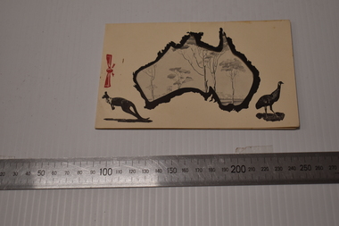
Notelet, 1940's
Issued for internee use at Camp 3, Tatura, by the Australian Young Mens' Christian AssociationChristmas greeting notelet, front "cover" features cut-out map of Australia, picture of a kangaroo in bottom left hand corner and of an emu in bottom right hand corner. Painted red bow at "spine"|Second page features sketch of internment camp trees and barracks. Part is seen through a cut out on front page. Printed on Page 3 in German : Christmas /New Year greeting and organisation responsible for production of notelet. Stapled togetherww2, camps, documents, cards -
 Flagstaff Hill Maritime Museum and Village
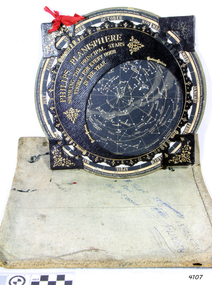
Planisphere, Early 20th Century
The word Planisphere (Latin planisphaerium) was originally used in the second century by Claudius Ptolemy to describe the representation of a spherical Earth by a map drawn in the plane. This usage continued into the Renaissance: for example Gerardus Mercator described his 1569 world map as a Planisphere. The word describes the representation of the star-filled celestial sphere on the plane. The first star chart to have the name "Planisphere" was made in 1624 by Jacob Bartsch. Bartsch was the son-in-law of Johannes Kepler, discoverer of Kepler's laws of planetary motion. A significant item of celestial mapping used by marine navigators This particular item was made and used in the first quarter to half of the 20th centuryPlanisphere of northern hemisphere, with canvas bag. Planisphere consists of a circular star chart attached at its centre to an opaque circular overlay that has a clear elliptical window or hole so that only a portion of the sky map will be visible in the window or hole area at any given time. The chart and overlay are mounted so that they are free to rotate about a common pivot point at their centres. The star chart contains the brightest stars, constellations and (possibly) deep-sky objects visible from a particular latitude on Earth. The night sky that one sees from the Earth depends on whether the observer is in the northern or southern hemispheres and the latitude. A Planisphere window is designed for a particular latitude and will be accurate enough for a certain band either side of that. Planisphere makers will usually offer them in a number of versions for different latitudes. Planispheres only show the stars visible from the observer's latitude; stars below the horizon are not included. A complete twenty-four-hour time cycle is marked on the rim of the overlay. A full twelve months of calendar dates are marked on the rim of the starchart. The window is marked to show the direction of the eastern and western horizons. The disc and overlay are adjusted so that the observer's local time of day on the overlay corresponds to that day's date on the star chart disc. The portion of the star chart visible in the window then represents (with a distortion because it is a flat surface representing a spherical volume) the distribution of stars in the sky at that moment for the Planispheres designed location. Users hold the Planisphere above their head with the eastern and western horizons correctly aligned to match the chart to actual star positions. "Made in Germany for GEORGE PHILIP & SONS Ltd. Geographical and Educational Depot, 32 Fleet Street, London" Canvas bag has "Capt. H (Howard) Tyler from Captain H. F. Woolf" "Tyler 22 ? St East Brighton" also "13 Halls St Flinders"flagstaff hill, warrnambool, shipwrecked-coast, flagstaff-hill, flagstaff-hill-maritime-museum, maritime-museum, shipwreck-coast, flagstaff-hill-maritime-village, planisphere, star map, marine navigation, maps, george philip & sons -
 Flagstaff Hill Maritime Museum and Village
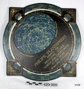
Planisphere, Early 20th Century
The word Planisphere (Latin planisphaerium) was originally used in the second century by Claudius Ptolemy to describe the representation of a spherical Earth by a map drawn in the plane. This usage continued into the Renaissance: for example Gerardus Mercator described his 1569 world map as a Planisphere. The word describes the representation of the star-filled celestial sphere on the plane. The first star chart to have the name "Planisphere" was made in 1624 by Jacob Bartsch. Bartsch was the son-in-law of Johannes Kepler, discoverer of Kepler's laws of planetary motionA significant item of celestial mapping used by marine navigators This particular item was made and used in the first quarter to half of the 20th century.Planisphere consists of a circular star chart attached at its centre to an opaque circular overlay that has a clear elliptical window or hole so that only a portion of the sky map will be visible in the window or hole area at any given time. The chart and overlay are mounted so that they are free to rotate about a common pivot point at their centers. The star chart contains the brightest stars, constellations and (possibly) deep-sky objects visible from a particular latitude on Earth. The night sky that one sees from the Earth depends on whether the observer is in the northern or southern hemispheres and the latitude. A Planisphere window is designed for a particular latitude and will be accurate enough for a certain band either side of that. Planisphere makers will usually offer them in a number of versions for different latitudes. Planispheres only show the stars visible from the observer's latitude; stars below the horizon are not included. A complete twenty-four-hour time cycle is marked on the rim of the overlay. A full twelve months of calendar dates are marked on the rim of the star chart. The window is marked to show the direction of the eastern and western horizons. The disc and overlay are adjusted so that the observer's local time of day on the overlay corresponds to that day's date on the star chart disc. The portion of the star chart visible in the window then represents (with a distortion because it is a flat surface representing a spherical volume) the distribution of stars in the sky at that moment for the Planispheres designed location. Users hold the Planisphere above their head with the eastern and western horizons correctly aligned to match the chart to actual star positions. "Sold by J DONNE & SON, Booksellers & Stationers, 349 Post Office Place Melbourne 349. Admiralty Chart Agents" and " Made in Germany for George Philip & Son Ltd" England . Signature "Capt E. B. ?..id, 22 Baund St"flagstaff hill, warrnambool, shipwrecked-coast, flagstaff-hill, flagstaff-hill-maritime-museum, maritime-museum, shipwreck-coast, flagstaff-hill-maritime-village, star map, marine navigation, maps, george philip & sons -
 Bendigo Historical Society Inc.
Book - STRAUCH COLLECTION: RESEARCHING YOUR GERMAN ANCESTORS
BHS CollectionManilla folder containing information on researching your German ancestors with illustrations and a map.genealogy, family, german, genealogy-german -
 Bendigo Historical Society Inc.
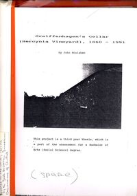
Book - STRAUCH COLLECTION: GREIFFENHAGENS CELLAR (HERCYNIA VINEYARD)
"Hercynia" was the largest vineyyard in the Bendigo District. It was started by Carl Wilhelm Greiffenhagen (William) and his cousins, twins, Carl and August Heine. The first vine cuttings were planted in 1860. The partners owned 300 acres at Axe Creek and in 1862 had 24 acres under vines and an orchard of 4 acres. By 1884 they had expanded to 30 acres of vines. They produced many award winning wines. August Heine ( 1832 - 1898) was born in Germany and came to Australia in 1854 with his twin brother Carl and their cousin William Greiffenhagen. Initially the three took up mining successfully but then the partnership bought 300 acres at Axe Creek and planted a vineyard. They also grew fruit and crops to feed the working horses. In 1870 August sold his interest in the vineyard and set up his own smaller vineyard at Sheepwash Gully. He had several business interests before he took up the caretaker position at the newly dug Weeroona lake, a position he held until his death. Carl Heine sold his interest in the vineyard in 1873 and returned to Germany. WIlliam Grieffenhagen (1834-1916) continued his very successful vineyard until the region was hit with a highly infectious vine disease in 1893. Although his own vines escaped infection, he was within the 2 mile quarantine area and was forced to dig out all his vines. He never replanted but depended on his orchard instead. He was a founding member of the Bendigo Agricultural Society and a local Shire councillor for several years. In 1870 he married Margaret Boyd.Binder containing information relating to Greiffenhagen's cellar (Hercynia Vineyard) 1860 - 1991 including black and white photographs & maps, compiled by John Houlahan as a third year thesis whichnis pat of the assessment for a Bachelor of Arts (Social Science) degree. Donated to the German Society 15/2/96 by the Grandfather of author Jack Houlahan.John Houlahanbook, bendigo, wineries, bendigo-history-axe creek- wineries- german -
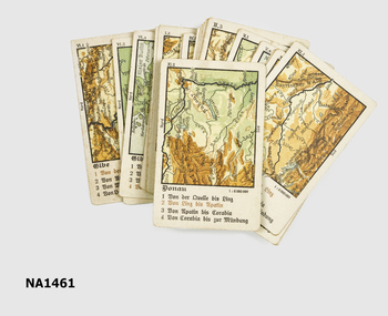
 Melbourne Tram Museum
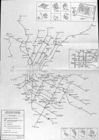
Map, P. Sohns, "Strassenbahn Melbourne Gleisplan", 10-9-1992
... . Tramways maps Melbourne Germany Map - A2 sheet folded to A4 ...Map of Melbourne's tramway system prepared for a German audience - as at 28-5-1992. Shows the track layout, crossovers, depots, route numbers, railway/tramway level crossings, terminus details, road names and a CBD insert. Prepared by P Sohns of Germany - dated 10-9-1992.Yields information Melbourne tramways and routes in 1992.Map - A2 sheet folded to A4.tramways, maps, melbourne, germany -
 Wangaratta RSL Sub Branch
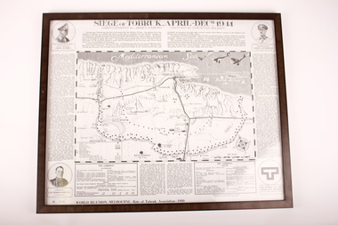
Poster - Framed Poster, Siege of Tobruk, 1980
... , German Afrika Korps. Map of Battle Zone. Lithographic of Corporal..., German Afrika Korps. Map of Battle Zone. Lithographic of Corporal ...Poster displays cartography and history of the Siege of Tobruk April to December 1941 Edition Poster ( No. 0768 )was produced for the World Reunion of the Rats of Tobruk Association held in Melbourne 1980Commemorates the Battle of TobrukBlack plastic frame containing poster of Map in centre with circles in each corner with images of soldiers and a symbol in lower right corner.Biographies of: Major General Leslie J Morshead - Tobruk Fortress Commander and Lieut General Erwin Rommel - Commander, German Afrika Korps. Map of Battle Zone. Lithographic of Corporal J.H.Edmonson VC - 2/17 Battalion.tobruk, 1941 -
Moorabbin Air Museum
Document (item) - Cierva C30 gyrocopter 5 WW2 photos of Soldiers on parade WW1 photo of Soldiers in trench accommodation near Ypres Wackett bomber schematic Boeing Vertol helicopter Poster of Sunderland short 201 squadron listing of CAC technical publications outline of CAC aircraft over 46 year mfr poster of the sabre aircraft family Plan of CAC lorimer st plant ordinance maps of: Ringwood area Korumburra Woolamai Western port lots of acid free paper Richthofen duelling with Major Hawker Nov 1916 Jimmy Doolittle first blind flight 1929 1914 Max Immelmann flying over Paris Sept 1917 Werner Voss in battle with S.E 5's June 1915 Warneford shoots down Zeppelin 1918 Willy Coppens collides with Zeppelin Oct 1918 William barker duels with 60 German planes May 1918 Edward Mannock outwits German planes July 1915 Nungesser flying Voisin bomber ohn Robertson Duigan and his Duigan Biplane Iroquois rescue Poster CT-4A airtrainer Ansett aircraft since 1920 Poster Nomad N22B mission master Commuter Qantas aircraft story Hawker De Havilland 60 years of aircraft FA 18 schematic Poster Bushrangers Iroquois Vietnam RAAF Poster Sopwith Snipe Albert Packer Poster, Soldiers in uniform Gyrocopter Posters Aircraft history Ordinance maps
-
 Bendigo Historical Society Inc.
Map - MARKS COLLECTION: CLAIM MAP SANDHURST
Original hand drawn map showing lease holders along Mt. Korong Road, Sandhurst area. Names include Gold Mines Co., Hercules Co., H. Koch, Prince Alfred Co, Advance Co., J. Steane, Skeals, Abel & Co., Mounts(?) Bay co., Wellington Co., Waterloo Co., Endeavour Co., W.H. Langdon, Bridgman & Co. Written in blue pencil on top RH corner in script Syme Well, Nova Ste (indecipherable), German Aleno Co., Concord, Rae. Written on back of map in black pen 'Maps'.map, bendigo, mining leases -
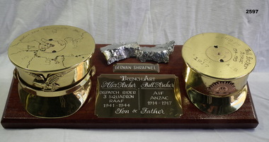 Bendigo Military Museum
Memorabilia - TRENCH ART, WW1, WW2, Post 1945 (estimated); Made in WWI and WWII and assembled upon return
William John ARCHER (Bill) No 321 enlisted in B Coy 21st Batt AIF on 18.1.15. Embarked for Eygpt 8.5.15. Hospital 9.9.15 with Influenza. Hospital 24.11.15 with Gastric Enteritis. Hospital 2.1.16 with Otitis Media. Transfers to the 57th Batt and embarks for France. Hospital with Trench Fever 4.10.16. Promoted to Cpl 28.4.17. Hospital 19.3.18 with Scabies. WIA 18.4.18 GSW's to chest and leg severe. Discharged from the AIF medically unfit 9.1.19. Alexander William ARCHER No 40637 enlisted in the RAAF on 16.5.41 age 18 years 8 months. He wanted to be a Mess Steward and was taken in as he had worked in similar work line. He then has 5 postings before embarking for Egypt on 2.4.1942 and was posted to No 3 SQD RAAF on 20.5.1942. Re mustered as a Motor Cyclist he became a Dispatch Rider on 8.9.1942 between the RAAF and the Army. Alex served in the Middle East and Italy with 3 SQD. He embarked from Egypt diagnosed with Kyphosis and Scoliosis on 5.2.1944. In Australia he was re mustered as Office Orderly on 6.7.1944 and then discharged from the RAAF on 2.10.1944 Medically Unfit. Wooden base with brass shells either end resembling Officers caps,one being WWI, the other WWII, both inscribed. Centre plaque inscribed Alex Archer and Bill Archer, father and son. Above the centre plaque is a piece of German shrapnel chrome plated Map - "North Africa, 1940", on left hand side, "18-Pounder, 1917, Bill Archer-Anzac, 1914-1919", on right hand side, "German shrapnel"handcrafts - trench art, metal craft- brassware, arms - ammunition, military history - souvenirs -
 Whitehorse Historical Society Inc.
Leisure object - Playing Cards
... cards). Cards and instruction sheet are written in German. Cards... are written in German. Cards have different maps on each one and all ...Pack of playing cards(box base, instruction sheet and 32 cards). Cards and instruction sheet are written in German. Cards have different maps on each one and all place names are written in German.recreations, games -
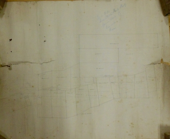
 Whitehorse Historical Society Inc.
Map - WW1 German Field Map, Übersichtskarte fur die 2. Armee (Nordabschnitt), C 1915
... Hand written English explanation of German Field Map... German Field Map Maps World War 1914 - 1918 Honybun Charles Paper ...Paper printed map of German Field positionsDetails area bounded by Mt. St. Quentin, Fresnoy, Riencourt, Canbrai and St AubertPaper printed map of German Field positionsmaps, world war 1914 - 1918, honybun charles -
 Bendigo Military Museum
Map - TRENCH, BATTLE & ORDNANCE MAPS FRANCE WW1, All 1918
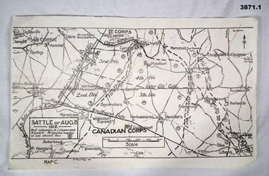
(.2) Areas on map relate to : The Hindenburg line on the left, from the top, Bony to Bellicourt to Bellenglise, Estrees to Brancourt. (.3) The River Somme runs through from top corner left bottom corner right. Main areas are Belloy, Picquigny, Bertangles, Montieres. The map finishes just short of “Amiens” Items in the collection relating to F.A.W Hutson No 3539 AIF. refer Cat No 922 for his service history.(.1) Map on paper showing the “Battle of August 1918”, Map C, The Advance to “Lions & Proyart”. (.2) Trench map, gauze lined, sheet 62B N.W, trenches corrected to 8.2.1918, German trenches in blue, scale 1:20,000, France. (.3) Ordnance survey map, May 1918, France, Edition 1, sheet 62 E N.E, scale 1:20,000, a canal and river runs through the centre(.2) On rear hand written “62 B N.W” (.3) On rear hand written “D.M.F 62 E N.E”august 1918, maps, somme -
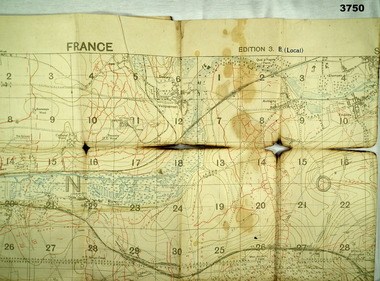
 Bendigo Military Museum
Map - TRENCH MAP, FRANCE WW1, 1918
Areas covered on this map, “Ribemont, Morlancourt, Dernacourt, Fricourt, Mericourt, Saily Le Sec” Item re William Alexander No 502 AIF. Refer Cat No 3746.3 for his service details.Trench map, France, Edition 2 E, sheet 62D N.E, scale 1:20,000, trenches corrected to 28.5.1918, German trenches in red, British in blue.map, france, trench -
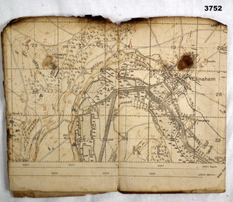
 Bendigo Military Museum
Map - TRENCH MAP, FRANCE WW1, 1918
Areas covered on this map “Corbie, Villers Brettoneux, Hangard, Blangy and Tronville Wood, River Somme”. Item re William Alexander No 502 AIF. Refer Cat No 3746.3 for his service details.Trench map, France, Edition 3B, trenches corrected to 7.7.1918, German trenches in red, British in blue, scale 1:20,000.map, france, trench -
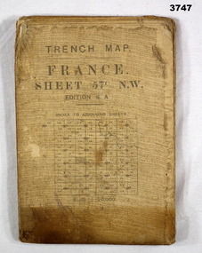 Bendigo Military Museum
Map - TRENCH MAP, FRANCE WW1, 1917
Main Australian areas on this map include “Grevillers, Bapaume and Fremicourt” Item re W.A Alexander No 502 AIF. Refer Cat No 3746.3 for his service details.Trench map, France, sheet No 57N.W. Edition6A, scale 1:20,000, trenches corrected to 7.2.1917, German trenches in red, on rear glossary of terms French to English.map, trench, france -
 Bendigo Military Museum
Map - TRENCH MAPS, BELGIUM WW1, 1) 1917; .2) & .3) 1916
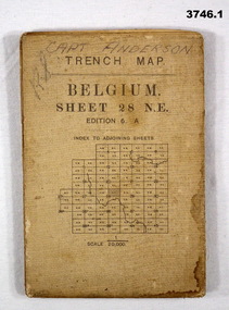
.1) Areas covered on this map include Zonnebeke, Broodseinde, Passchendaele, Westhoek, Glencorse Wood & Black Watch Corner. .2) Areas covered on this map include Bailleul, Neuve Eglise, Messines, Wyschaete, Warneton & Hollebeke. .3) Areas covered on this map include Poperinghe, Ypres, Dickebusch & Zillebeke. The maps are part of a collection of 27 collected by William Arthur ALEXANDER, No 502 AIF. He enlisted in the 8th reinforcements MG Coy 3 on 5.9.1916 aged 21 years. Embarked for England on 23.11.1916, transferred then to the 5th Div MG Coy. Embarked for France on 26.4.1917 then transferred to the 13th MG Coy on 16.6.1917. WIA 28.9.1917 gassed, he is later hospitalized with Colitis. Rejoined unit in the field 18.6.1918. Discharged from the AIF 18.9.1919..1) Trench Map, Belgium, sheet 28 NE Edition 6A, folding, scale 1.20,000, trenches corrected to 3.7.1917, German trenches in red. On rear glossary of terms French to English. .2) Trench Map, Belgium & France, sheet 28 SW Edition 3D, folding, scale 1.20,000, trenches corrected to 22.6.1916. German trenches in red, British in blue. On rear glossary of terms French to English. .3) Trench Map, Belgium, sheet 28 NW Edition 3D, folding, scale 1.20,000, trenches corrected to 25.6.1916. German trenches in red, British in blue. On rear glossary of terms French to English..1) Handwritten on front: “CAPT ANDERSON”maps, trench -
 Bendigo Military Museum
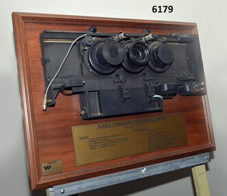
Plaque - Mounted Klimsch Commodore Cartographic Camera Lenses, WYCOMBE Constructions Pty Ltd, 1997
These are the Lenses from the Klimsch Commodore Cartographic Camera that was located in Lithographic Squadron at the Army Survey Regiment, Fortuna, Bendigo. The KLIMSCH Commodore camera was originally introduced to the Survey Regiment in 1953 and was the largest in the Southern Hemisphere. It was replaced with a new model of the same size in 1977. These lenses are from this new model. The new model with its computer-based interface provided productivity gains with improved speed and its consistent results led to less wastage in time and materials. Its variomat lens system provided improved retention of map feature linear weights during the camera reduction process. The camera which was specially made for the Australian Army in Germany was fully automatic and power operated. It was claimed to be one of the biggest automatic cameras of its type in the world. It was made to the specifications of the Royal Australian Army Survey Corps to assist in the production of the very high standard maps for the Australian Army. THIS KLIMSCH COMMODORE CARTOGRAPHIC CAMERA was in operation 1977 - 1997". It was a Precision Darkroom Camera especially suited for Cartographic Reproduction of Line, Continous Tone, Halftone and Colour Separation. Reproduction of Negatives and Positives from a variety of Reflection or Transmission Originals. Its characteristics were: Maximum Negative Size 1.27m sq, Copy Holder (Vacuum) 2m sq, Maximum Enlargement 400%, Maximum Reduction 13%, Automatic 60, 90 and 120cm Focal Length Lens, Transmission or Reflection Originals, Pulsed Xenon, Photo Flood or Fluorescent Tube Light Source, Maximum Reflection Original 1.3m x 1.85m, Maximum Transmission Original 1.3m x 1.85m, Exposure Light Monitoring System." The camera was superseded by computerized image manipulation software associated with the Automap system. These significant and extremely high-quality Lenses were retrieved by WYCOMBE Constructions Pty Ltd during the demolishment of the camera in 1997 and then mounted on a display board. See also Item 6189.4P for more photographs of the camera.Lenses from the Klimsch Commodore Cartographic Camera mounted on a very heavy timber display board. The display board contains an engraved plate that describes the technical characteristics of the camera."KLIMSCH COMMODORE CARTOGRAPHIC CAMERA 1977 - 1997", "FUNCTION: Precision Darkroom Camera especially suited for Cartographic Reproduction of Line, Continous Tone, Halftone and Colour Separation. Reproduction of Negatives and Positives from a variety of Reflection or Transmission Originals." "CHARACTERISTICS: Maximum Neg Size 1.27m sq, Copy Holder 2m sq, Maximum Enlargement 400%, Maximum Reduction 13%, Automatic 60, 90, 120cm Focal Length Lens, Transmission or Reflection Originals, Pulsed Xenon, Photo Flood or Fluorescent Tube Light Source, Maximum Reflection Original 1.3m x 1.85m, Maximum Transmission Original 1.3m x 1.85m, Exposure Light Monitoring System." royal australian survey corps, rasvy, fortuna, army survey regiment, army svy regt, asr, litho -
 Monbulk RSL Sub Branch
Book, Time-Life Books, The battle of the Atlantic, 1977
Germany attempts to strangle Britain--U-boats--Bismarck--convoys--Allied counterattack.Index, bib, ill, , maps, p.208.non-fictionGermany attempts to strangle Britain--U-boats--Bismarck--convoys--Allied counterattack. world war 1939-1945 - naval operations, world war 1939-1945 - campaigns - atlantic ocean