Showing 203 items matching "mentone"
-
 City of Moorabbin Historical Society (Operating the Box Cottage Museum)
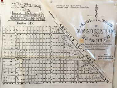
Document, photocopy of Plan of Beaumaris 1853, c1960
Beaumaris includes two early estates in the parish of Moorabbin developed by Josiah Holloway from 1852. Named Beaumaris Town and Beaumaris Estate (after the pastoral run in the area and ultimately after Beaumaris in Wales), the lots comprising them were marketed by Mr Holloway's suggesting that the railway was imminent and a canal would be built. The township developed slowly, a Post Office opened on 1 March 1868, but was replaced next month by Gipsy Village office (now Sandringham) In 1862 Beaumaris was one of the early settler communities within the boundaries of the Moorabbin District Roads Board , the region’s first local government authority. Beaumaris is a suburb in Melbourne, Victoria, Australia, 19 km south-east from Melbourne's central business district. .Since the Amalgamation of Councils 1994 the local government area is the City of Bayside which includes Brighton. A Photocopy of the Plan of Beaumaris 1853 A3moorabbin, county of bourke, brighton, beaumaris, pioneers, early settlers. market gardeners, cheltenham, king. john, holloway josiah, whorral charles, arthur’s seat road, nepean highway, morabbin district roads board, sandringham, mordialloc, mentone -
 Glen Eira Historical Society
Album - Album page, Booran Road, 30, Circa 1972
This photograph is part of the Caulfield Historical Album 1972. This album was created in approximately 1972 as part of a project by the Caulfield Historical Society to assist in identifying buildings worthy of preservation. The album is related to a Survey the Caulfield Historical Society developed in collaboration with the National Trust of Australia (Victoria) and Caulfield City Council to identify historic buildings within the City of Caulfield that warranted the protection of a National Trust Classification. Principal photographer thought to be Trevor Hart, member of Caulfield Historical Society. Most photographs were taken between 1966-1972 with a small number of photographs being older and from unknown sources. All photographs are black and white except where stated, with 386 photographs over 198 pages. From Glen Eira Heritage Management Plan 1996 by Andrew Ward: In 1888, John Leek, a trainer, owned Lot 15, measuring one and three quarter acres, in Booran Road, north side between Glen Eira and Neerim Roads. The land backed onto the Caulfield Racecourse Reserve. NAV was £45. In 1890 Leek built for his residence, a ten roomed brick house on the site. NAV was £200. Leek was the owner/trainer of "Ingliston" who won the Caulfield Cup in 1900. Upon the horse's death in 1901, Leek is understood to have defied tradition by spending £20 on boots for the "ragged urchins in Bourke Street" instead of "shouting" at the bar. By 1899, the property was owned and occupied by Alfred Merrill, a dentist and was known as "Andover". NA V had decreased to £ll0. By 1910, Leslie Macdonald, a gentleman had purchased the property and renamed it "Moidart". In 1910-11 Macdonald sold it to John Robertson. The property had extensive wood stables on its north-east boundary and several other outbuildings. The house continued to be described as "Brick, ten rooms" as it was in 1926 when it was owned and occupied by John Arthur, a managing director. The land measured la.2r.31p. and had a NAV of £235. Nine people lived there. In 1926, Arthur also owned the adjoining Lot 16. Other racehorses of note, known to have been stabled here include Sobar, Havelock, Proud, Future and Lord.Victorian Heritage Register https://vhd.heritagecouncil.vic.gov.au/places/13532 What is significant? Lord Lodge is a thoroughbred racehorse training complex adjacent to Caulfield Racecourse, established in 1890. The area immediately around the racecourse has been associated with horse racing activities and businesses servicing the industry since the development of the racecourse in late the 19th century. Lord Lodge was named by the present occupants after the champion racehorse Lord who was stabled there in the 1950s. In the early 20th century the property was known as 'Andover' and subsequently 'Moidart'. The site consists of a single storey brick Italianate villa, jockeys' quarters, stables and open day yards with direct access to Caulfield racecourse from the rear of the property. The villa of 10 rooms on bluestone foundations was constructed in 1890 by John Leek, a horse trainer who purchased the newly subdivided land in 1888. The house has many Victorian Italianate or Boom Style features although it is more modest than many villas of its style. It has an asymmetrical facade with a faceted bay window and a prominent central tower with low pitch pyramidal roof that provides a clear view of the racecourse. Other characteristic features include stilted segmented arches, bracketed eaves, stucco wall finish and cast cement ornamentation. A room has been added on the north-facing verandah in sympathetic style and finish. Internally the rooms are substantially intact with original marble fireplaces and intricate ceiling roses and cornices. An entrance toward the rear of the southern side of the house is said to be where the stable hands, jockeys and other staff lined up for their meals. In the southeast corner of the property, backing directly on to Caulfield racecourse, is a substantial late Victorian timber stable, probably constructed in the 1890s but first appearing on the property title in 1910. The stable has 12 stalls, a loft and brick pavement and jerkin head roof form with varnished pine-lined ceiling carried on a chamfered timber frame. It has an original roof lantern. The doors of the stalls are not the original sliding doors but swing doors obtained from a barn at Epsom Racecourse in Mordialloc prior to demolition. Outside the gambrel roof has fretted barges but the building is otherwise utilitarian. Timber throughout the stalls has been worn by chewing and rubbing of horses over the century of its use. In the southern half of the property are open day yards where the racehorses are kept during the day. The red brick, single storey jockeys' quarters to the rear of the villa were probably built around 1950. A small brick, possibly late Victorian structure on the eastern boundary thought to have originally been a gardening shed, has been converted to a stable of two stalls. Modern concrete brick stables fill the northeast portion of the property. At the front of the property two Moreton Bay Figs (Ficus macrophylla), probably planted in the late 19th century, provide shade for horses in the day yards. In the 1890s John Leek sold the property, relocating his training facility to one of the newly established racecourses at Mentone or Mordialloc (Epsom). By 1899, the property was owned and occupied by Alfred Merrill, a dentist, who named the property 'Andover'. In 1910 it was purchased by Leslie McDonald, a gentleman, and renamed 'Moidart'; sold in 1910-1911 to John Robertson; and again in 1926 to John Arthur, a racehorse owner. The Victorian Amateur Turf Club purchased the property in the late 1930s and since this time has been leased to racehorse trainers. It is unclear whether the property operated as a training facility between 1899 - 1926. Several notable trainers and jockeys are associated with Lord Lodge. The best known is Arthur 'Scobie' Breasley, Australia's most successful jockey who was apprenticed to trainer Pat Quinlan at Lord Lodge (then 'Moidart') from 1928 - 1935. Breasley rode winners of the Caulfield Cup in four successive years 1942-45 and again in 1952. John Leek, the original owner of Lord Lodge trained Ingliston, the 1900 Caulfield Cup winner. Along with 'Lord' a number of well known racehorses including Sobar, Havelock, Proud and Future were trained at Lord Lodge .....Page 40 of Photograph Album with three landscape photographs of the exterior of this house.Handwritten: 30 Booran Road [top right hand corner] / 40 [bottom right]trevor hart, jenny o'donnell, booran road, mansion, caulfield east, ingliston, sobar, havelock, proud, future, lord, andover, moidart, lord lodge, grace darling, caulfield racecourse reserve, victorian amateur turf club, historic buildings register, national estate register, caulfield cup, horses, stables, horse racing, racehorses, outbuildings, racehorse trainers, depression, 1890s, brick houses, mansions, towers, verandahs, stained glass, italianate style, victorian style, architectural features, architectural styles, john leek, leslie macdonald, john arthur, john robertson, alfred merrill, jenny odonnell -
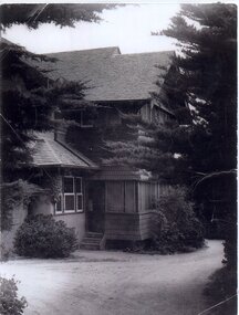
 City of Moorabbin Historical Society (Operating the Box Cottage Museum)
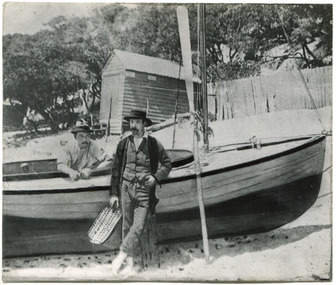
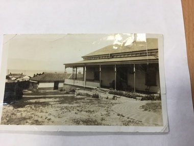
Photograph, 2 B&W, 1898 The O'Maras', Sandringham Fishermen : Date Unknown, Mud Brick House, 1898 The O'Maras', Sandringham Fishermen Date Unknown, Mud Brick House, 1898
The O'Maras, of Sandringham fishermen. Early mud brick house. Located in Moorabbin and was still there in 1940. The house was situated in Reserve Road, almost opposite Wangara Road, (formerly Cemetery Road). About twelve years ago, (* the writer states no year), there was a vacant block where the house used to be - it was next to a electrical factory. 2x Black and White Photographs. (i) An 1898 photograph showing two men with a fishing boat on the beach. A beach house / shed , paling fence and tall tea-trees are seen in the background. (ii) A large early mud brick house with a tin roof, chimney and a water tank sitting on a block of grassed landWritten on back (i) The O'Maras / Sandringham / fishermen 1898 (ii) Mud brick house at Moorabbin ( house was there in 1940) / Situated in Reserve Road almost opposite Wangara Road / ( formerly Cemetery Road ). About 12 years ago there was a vacant block where the house used to be and it was next to an electrical factory. unsigned undatedthe o'maras, sandringham fisherman, 1898, mud brick house, moorabbin, wangara road, reserve road, electrical factory, early settlers, pioneers, shire of moorabbin, sandringham, beaumaris, mentone, fishermen, dairy farmaers, poultry farmers, market gardeners, -
 City of Moorabbin Historical Society (Operating the Box Cottage Museum)
Newsletter, City of Moorabbin Historical Society Oct 2010 jpg, pdf, October 2010
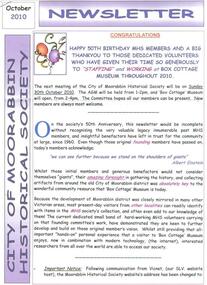
The City of Moorabbin Historical Society was formed c 1960 by a group of Moorabbin residents who were concerned that the history of the area should be preserved. A good response to a call for items related to the historical area of Moorabbin Shire brought donations of a wide variety of artefacts which are now preserved by the current members of CMHS at Box Cottage Museum . Helen Stanley, Secretary of CMHS, began producing a Newsletter for members in April 2007 to provide current information and well researched items of historical interest. This Issue celebrates the 50th Anniversary of CMHS Helen Stanley has produced a bi-monthly Newsletter, 2007 - 2013, for the members of the City of Moorabbin Historical Society that contains well researched interesting historical items, notification of upcoming events, current advice from Royal Australian Historical Society , Museums Australia Victoria and activities of Local Historical Societies. The Newsletter is an important record of the activities of the CMHS and this month Celebrating the 50th Anniversary of CMHS.Issue 18 of the bi-monthly, City of Moorabbin Historical Society Newsletter produced by Society member and Secretary, Mrs Helen Stanley in October 2010. . Notice of AGM October 30th and Celebration of 50th Anniversary of CMHS. The Founding Members of CMHS are thanked and praised for their foresight, generosity of time and energy and for organising the collection of historical artefacts that created ‘Box Cottage Museum” as it is today. Mrs Dorothy Booth, FoMRGS, has donated her mother’s wedding dress to Box Cottage Museum, and John O’Callaghan, Glen Eira Historical Society, will donate a rebuilt computer. We are now commencing a Catalogue of our Library Books. The Story of the Elster Creek is attached.CITY of MOORABBIN HISTORICAL SOCIETY / OCTOBER 2010 NEWSLETTERcity of moorabbin historical society, stanley helen, booth dorothy, melbourne, moorabbin, brighton, cheltenham, ormond, bentleigh, market gardeners, pioneers, early settlers, elster creek, moorabbin shire, box cottage museum, state library of victoria, vicnet, city of moorabbin, box william, clothing, wedding dress, friends of mentone railway gardens, glen eira historical society, o’callaghan john -
 City of Moorabbin Historical Society (Operating the Box Cottage Museum)
Photograph - Map of Dendy's Special Survey, 1852 Map of Henry Dendy's Special Survey of 1841, 19th Century
A Map drawn in 1852 that shows the 5,120 acres that formed Dendy's Special Survey of 1841. In 1840 Henry Dendy, a farmer in Surrey, England acquired a "Special Survey" from the Commissioners for Land and Emigration which gave Dendy the right to choose land in Port Phillip for the "bargain basement" price of only £1 per acre for 5120 acres, (an area of 8 square miles). The Special Survey also included the right to "the shipment of a worker for every £20 spent on land, whose free passage was paid by the Crown, equalling a total of 100 workers ". Accordingly Dendy sold his English holdings and paid the required £5120 and arrived in Melbourne in February 1841. However by this time land in the new colony was selling for £5 - £40 per acre. Because Henry Dendy possessed the order from the Colonial Office in London he was able to successfully oppose Governor LaTrobe's attempts to alter the price of the land. Dendy appointed Jonathan Were, (an entrepreneur, who had arrived in 1839), as his Manager and who later became a partner. Together, Dendy and Were decided on an area 5 miles south from Melbourne, bounded by North Road, East Boundary Road, South Road and to the west by Port Phillip Bay. Were and Dendy pitched their tents in the area now known as ' Park St, Brighton' and sank a well near the corner of 'St Andrew's St and Wells St'. By 1845 J.B Were and Company had bought almost half of Dendy's land and Were built himself "Moorabbin House" in Were St Brighton made from stone, quarried from local cliffs. It was still standing in 1924. Legend records Moorabbin is named after the Aboriginal word for ' Mother's Milk ' The soil is very fertile and well supplied with water especially in the area called 'East Brighton' - now known as Bentleigh and East Bentleigh - By 1850 the area had developed with numerous market gardens, dairy farms, fruit gardens and vineyards supplying food for the growing population of Melbourne.This Map shows the birth of the Brighton and Moorabbin area. On 18th January1859 Brighton was proclaimed a Municipality and a Borough by October 1863. Meanwhile, following a Petition, the area of East and South Brighton, incorporating Mordialloc, Cheltenham, Mentone, Sandringham and Oakleigh separated from Brighton to form the Moorabbin District Roads Board becoming the first Local Government Authority. Col. William Mair was elected as the first Chairman of the Moorabbin Roads Board. Moorabbin Shire 1871 developed further and was declared a City in1934. The City of Moorabbin was the largest Municipality in Melbourne before the Amalgamation of Councils in 1994 when it was divided in the south to City of Kingston and in the north to City of Glen Eira A Photo-lithographed 1852 Map showing the 5,120 acres that formed Dendy's Special Survey of 1841. Henry Dendy & Jonathan Were chose an area 5 miles south from Melbourne, bounded by North Road, East Boundary Road, South Road and to the west by Port Phillip Bay. Moorabbin County of Bourke / Photo-Lithographed at the department of Lands and Survey. /Melbourne. / Price 1/- brighton, moorabbin, bentleigh, cheltenham, dendy henry, bent thomas, were jonathan, special survey -
 City of Moorabbin Historical Society (Operating the Box Cottage Museum)
Badge - City of Moorabbin - 50 Years Medal, 1984-85
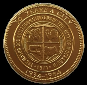
A gold-plated medal issued by the City of Moorabbin to commemorate the quincentenary of Victoria in 1984-5. It features the City Shield incorporating vegetables, a rooster, a cow and a house, and the sesquicentenary logo. The township of Moorabbin, known as South Brighton until 1909, remained small, with the Plough and Harrow Hotel as its main building. In 1917 Sandringham borough was formed by severance from Moorabbin shire and in 1920 Mentone and Mordialloc were also severed. In the remaining Moorabbin shire the Moorabbin township was still small (1,770 persons), but the shire grew in population during the 1930s. On 10 October 1934 it was proclaimed a city. It existed as a separate municipality until 1995. When local government boundaries were changed in 1994 about half of Moorabbin city was united with Glen Eira city and about half with Kingston city. On 15 December, 1994 the City of Chelsea, parts of the Cities of Mordialloc, Moorabbin, Springvale and Oakleigh were amalgamated to create the City of Kingston by Order of the Governor in Council. On the same day Glen Eira City Council was formed from the City of Caulfield and the remaining part of the City of Moorabbin.Gold Plated Medal Side one: Within a wide rim formed by a line circle, the City Shield incorporating vegetables, a rooster, a cow and a house; around, THE MAYOR COUNCILLORS & CITIZENS OF THE CITY OF MOORABBIN; around on broad rim, 50 YEARS A CITY 1934 - 1984. Side 2: Logo of the Victorian sesquicentenary; below, VICTORIA 150 / GROWING TOGETHER 1984-5 at rim in small letters the mint name, BRIM MELBTHE MAYOR COUNCILLORS & CITIZENS OF THE CITY OF MOORABBIN; VICTORIA 150 / GROWING TOGETHER 1984-5.city of moorabbin, victorian sesquincentenary, moorabbin shire, councillors moorabbin, cheltenham, bentleigh, moorabbin, le page family, cr coates l.r, cr sheppard l.a., cr cooper j.c. -
 Ballarat Heritage Services
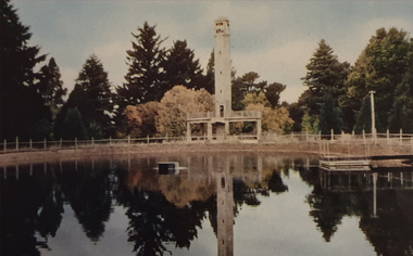
Photograph, Nucolorvue, Daylesford Pioneer Tower in Wombat Garrdens, 1957
Daylesford is a tourist town in Central Victorian, known for its mineral water springs.Image of the Daylesford Pioneer Memorial Tower in Wombat Gardens, Daylesford.Daylesford, Victoria, Australia This famous holiday resort is famous for its up-to-date facilities, as well as for its natural attractions. The mineral Springs are renowned for their high medicinal elements. The visitor finds ample to amuse, in excellent fishing, boating, Boating, Swimming, golfing, hiking and riding. The district provides a wide range of typical Australian bush scenery, and the altitude of 2,000 feet above sea level as a tonic effect on all. Daylesford has modern hotels, guest houses, shops and places of amusement, also many other places of interest within short travelling distance. Bendigo, 50 miles, Ballara 30 miles, and Melbourne 75 miles, bring Daylesford within easy reach of many parts of Victoria. daylesford, pioneer tower, wombat gardens -
 Ballarat Heritage Services
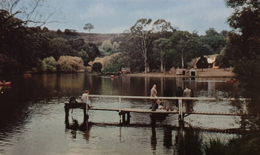
Photograph, Nucolorvue, A Corner of Jubilee Lake, Daylesford, 1957
Daylesford is a tourist town in Central Victorian, known for its mineral water springs.Image of Jubilee Lake, Daylesford.Daylesford, Victoria, Australia This famous holiday resort is famous for its up-to-date facilities, as well as for its natural attractions. The mineral Springs are renowned for their high medicinal elements. The visitor finds ample to amuse, in excellent fishing, boating, Boating, Swimming, golfing, hiking and riding. The district provides a wide range of typical Australian bush scenery, and the altitude of 2,000 feet above sea level as a tonic effect on all. Daylesford has modern hotels, guest houses, shops and places of amusement, also many other places of interest within short travelling distance. Bendigo, 50 miles, Ballara 30 miles, and Melbourne 75 miles, bring Daylesford within easy reach of many parts of Victoria. daylesford, jubilee lake, pier -
 Ballarat Heritage Services
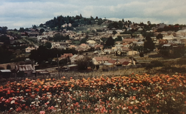
Photograph, Nucolorvue, Panorama Looking Towards Wombat Hill at Daylesford, 1957
Daylesford is a tourist town in Central Victorian, known for its mineral water springs.Panorama Looking Towards Wombat Hill at DaylesfordDaylesford, Victoria, Australia This famous holiday resort is famous for its up-to-date facilities, as well as for its natural attractions. The mineral Springs are renowned for their high medicinal elements. The visitor finds ample to amuse, in excellent fishing, boating, Boating, Swimming, golfing, hiking and riding. The district provides a wide range of typical Australian bush scenery, and the altitude of 2,000 feet above sea level as a tonic effect on all. Daylesford has modern hotels, guest houses, shops and places of amusement, also many other places of interest within short travelling distance. Bendigo, 50 miles, Ballara 30 miles, and Melbourne 75 miles, bring Daylesford within easy reach of many parts of Victoria. daylesford, wombat hill, flora -
 Ballarat Heritage Services
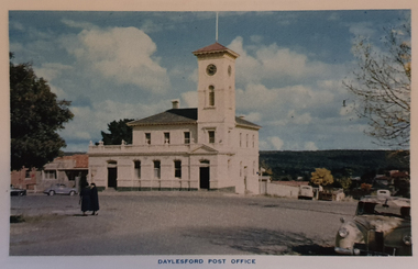
Photograph, Nucolorvue, Daylesford Post Office, 1957
Daylesford is a tourist town in Central Victorian, known for its mineral water springs.View of the Daylesford Post OfficeDaylesford, Victoria, Australia This famous holiday resort is famous for its up-to-date facilities, as well as for its natural attractions. The mineral Springs are renowned for their high medicinal elements. The visitor finds ample to amuse, in excellent fishing, boating, Boating, Swimming, golfing, hiking and riding. The district provides a wide range of typical Australian bush scenery, and the altitude of 2,000 feet above sea level as a tonic effect on all. Daylesford has modern hotels, guest houses, shops and places of amusement, also many other places of interest within short travelling distance. Bendigo, 50 miles, Ballara 30 miles, and Melbourne 75 miles, bring Daylesford within easy reach of many parts of Victoria. daylesford, daylesford post office -
 Ballarat Heritage Services
Photograph, Nucolorvue, Daylesford Primary School, 1957
Daylesford is a tourist town in Central Victorian, known for its mineral water springs.View of the Daylesford Primary SchoolDaylesford, Victoria, Australia This famous holiday resort is famous for its up-to-date facilities, as well as for its natural attractions. The mineral Springs are renowned for their high medicinal elements. The visitor finds ample to amuse, in excellent fishing, boating, Boating, Swimming, golfing, hiking and riding. The district provides a wide range of typical Australian bush scenery, and the altitude of 2,000 feet above sea level as a tonic effect on all. Daylesford has modern hotels, guest houses, shops and places of amusement, also many other places of interest within short travelling distance. Bendigo, 50 miles, Ballara 30 miles, and Melbourne 75 miles, bring Daylesford within easy reach of many parts of Victoria. daylesford, daylesford primary school, primary state school -
 Ballarat Heritage Services
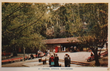
Photograph, Nucolorvue, Central Springs Daylesford, 1957
Daylesford is a tourist town in Central Victorian, known for its mineral water springs.Central Springs DaylesfordDaylesford, Victoria, Australia This famous holiday resort is famous for its up-to-date facilities, as well as for its natural attractions. The mineral Springs are renowned for their high medicinal elements. The visitor finds ample to amuse, in excellent fishing, boating, Boating, Swimming, golfing, hiking and riding. The district provides a wide range of typical Australian bush scenery, and the altitude of 2,000 feet above sea level as a tonic effect on all. Daylesford has modern hotels, guest houses, shops and places of amusement, also many other places of interest within short travelling distance. Bendigo, 50 miles, Ballara 30 miles, and Melbourne 75 miles, bring Daylesford within easy reach of many parts of Victoria. daylesford, central springs, mineral water, mineral water springs, kiosk -
 Ballarat Heritage Services
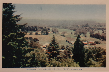
Photograph, Nucolorvue, Panorama from the Pioneed Memorial Tower, Daylesford, 1957
Daylesford is a tourist town in Central Victorian, known for its mineral water springs.Central Springs DaylesfordDaylesford, Victoria, Australia This famous holiday resort is famous for its up-to-date facilities, as well as for its natural attractions. The mineral Springs are renowned for their high medicinal elements. The visitor finds ample to amuse, in excellent fishing, boating, Boating, Swimming, golfing, hiking and riding. The district provides a wide range of typical Australian bush scenery, and the altitude of 2,000 feet above sea level as a tonic effect on all. Daylesford has modern hotels, guest houses, shops and places of amusement, also many other places of interest within short travelling distance. Bendigo, 50 miles, Ballara 30 miles, and Melbourne 75 miles, bring Daylesford within easy reach of many parts of Victoria. daylesford, wombat gardens, wombat hill gardens, daylesford pioneer memorial tower, landscape -
 Ballarat Heritage Services
Photograph, Nucolorvue, First Fairway of Golf Course, Hepburn, 1957
Daylesford is a tourist town in Central Victorian, known for its mineral water springs.The first course at the Hepburn Golf Club.Daylesford, Victoria, Australia This famous holiday resort is famous for its up-to-date facilities, as well as for its natural attractions. The mineral Springs are renowned for their high medicinal elements. The visitor finds ample to amuse, in excellent fishing, boating, Boating, Swimming, golfing, hiking and riding. The district provides a wide range of typical Australian bush scenery, and the altitude of 2,000 feet above sea level as a tonic effect on all. Daylesford has modern hotels, guest houses, shops and places of amusement, also many other places of interest within short travelling distance. Bendigo, 50 miles, Ballara 30 miles, and Melbourne 75 miles, bring Daylesford within easy reach of many parts of Victoria. daylesford, fairway, hepburn golf course -
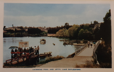 Ballarat Heritage Services
Photograph, Nucolorvue, Swimming Pool and Jetty, Lake Daylesford, 1957
Daylesford is a tourist town in Central Victorian, known for its mineral water springs.Swimming Pool and Jetty, Lake DaylesfordDaylesford, Victoria, Australia This famous holiday resort is famous for its up-to-date facilities, as well as for its natural attractions. The mineral Springs are renowned for their high medicinal elements. The visitor finds ample to amuse, in excellent fishing, boating, Boating, Swimming, golfing, hiking and riding. The district provides a wide range of typical Australian bush scenery, and the altitude of 2,000 feet above sea level as a tonic effect on all. Daylesford has modern hotels, guest houses, shops and places of amusement, also many other places of interest within short travelling distance. Bendigo, 50 miles, Ballara 30 miles, and Melbourne 75 miles, bring Daylesford within easy reach of many parts of Victoria. daylesford, swimming pool and jetty, lake daylesford, swimming -
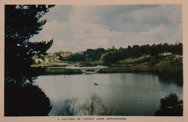 Ballarat Heritage Services
Photograph, Nucolorvue, A Section of Lake Daylesford, 1957
Daylesford is a tourist town in Central Victorian, known for its mineral water springs.A Section of Lake DaylesfordDaylesford, Victoria, Australia This famous holiday resort is famous for its up-to-date facilities, as well as for its natural attractions. The mineral Springs are renowned for their high medicinal elements. The visitor finds ample to amuse, in excellent fishing, boating, Boating, Swimming, golfing, hiking and riding. The district provides a wide range of typical Australian bush scenery, and the altitude of 2,000 feet above sea level as a tonic effect on all. Daylesford has modern hotels, guest houses, shops and places of amusement, also many other places of interest within short travelling distance. Bendigo, 50 miles, Ballara 30 miles, and Melbourne 75 miles, bring Daylesford within easy reach of many parts of Victoria. daylesford, swimming, lake daylesford -
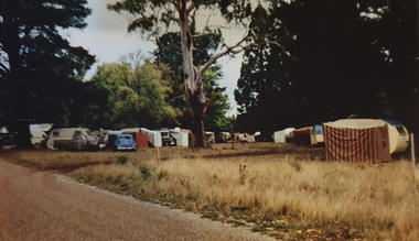 Ballarat Heritage Services
Photograph, Nucolorvue, Caravans in Victoria Park Camping Ground, Daylesford, 1957
Daylesford is a tourist town in Central Victorian, known for its mineral water springs.Caravans in Victoria Park Camping Ground, DaylesfordDaylesford, Victoria, Australia This famous holiday resort is famous for its up-to-date facilities, as well as for its natural attractions. The mineral Springs are renowned for their high medicinal elements. The visitor finds ample to amuse, in excellent fishing, boating, Boating, Swimming, golfing, hiking and riding. The district provides a wide range of typical Australian bush scenery, and the altitude of 2,000 feet above sea level as a tonic effect on all. Daylesford has modern hotels, guest houses, shops and places of amusement, also many other places of interest within short travelling distance. Bendigo, 50 miles, Ballara 30 miles, and Melbourne 75 miles, bring Daylesford within easy reach of many parts of Victoria. daylesford, victoria park caravan park, camping, victoria park, caravan park -
 Mentone Girls' Grammar School Digital Archives
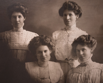
Photograph - Simpson sisters, 4
photograph of the 4 Simpson sisters -
 Mentone Girls' Grammar School Digital Archives
Photograph - 1997 Opening of the Janice Douglas Junior Centre by Premier Jeff Kennett
photograph of the 1997 Opening of the Janice Douglas Junior Centre, with Principal Janice Douglas, Premier Jeff Kennett and School Council President Alan Frees -
 Mentone Girls' Grammar School Digital Archives
Photograph - Mentone Girls' Grammar Main House
The original building purchased by Jeannie McCowan at 88 Beach Road when the School had to relocate from the current St. Bede's site. When the School increased in size, as promised, a House was named after Miss McCowan in 1969. -
 Mordialloc & District Historical Society Inc
Tin, Unknown
Represents two important features of Australian culture: tea drinking and unique animalsBushells tea container completely covered with printed paintings of Australian fauna: kangaroo, koala, kookaburra and emu. Blue, with figures in grey, black and white. Container held 1 pound. Embossed on base: "Bushells/Tea of Flavor/FIRST GRADE/1 LB NET" Embossed on lid: "Bushells/Tea of Flavor"bushells, container, kitchen -
 Mordialloc & District Historical Society Inc
Bread Tin, Unknown
Used in commercial bakery, probably in the bakery built in the 1920s that now houses the Mordialloc & District Historical Society.Folded metal tins, two units braced together by metal straps and rivets. Tins are rectangular and bake 1 pound loaves. Black coating on outside of tins.Pressed into long sides: "608" Pressed into ends: "7 74" [very faintly]bakery, kitchen -
 Mordialloc & District Historical Society Inc
Doyley Holder, circa 1900s
This doyley holder was used by Mrs N Bellingham.Typical household item from the period, representative of handcrafted items.Blue doyley holder, consisting of two circular pieces of card covered in suede-like fabric on the outside, and blue satin-like fabric on the inside. One side has large red suede-like fabric bird holding a small sign in its beak on it, and the other has four red flowers of similar material around the rim. There are two thin pink ribbons on the inside of the piece with flowers. On sign in bird's mouth: "D. Ouleys [?]"household, doyley, doiley, handcraft, mrs n. bellingham, mordialloc -
 Mordialloc & District Historical Society Inc
Photograph, Slate Roof Timber House. Possibly in High Street, Mordialloc, c1900, c1900
not know Shows typical house in Mordialloc at start of 20th century.Small black & white photograph of timber house with veranda showing some of the garden. Possible road in front of house.On back "Kodak Print" Hand written "MORDIALLOC" Printed "M 906"mordialloc, house, photograph -
 Mordialloc & District Historical Society Inc
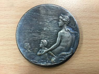
Lifesaving Medal
Lifesaving clubs formed an important part of the social history of Mordialloc.Silver coloured lifesaving medal awarded by the Education Department of Victoria. 2 inches in diameter, featuring a male figure holding a palm frond over his shoulder on the front and a female figure holding a trident and two children in the sea on the reverse."Education Department Victoria Swimming and Lifesaving". "Presented 1932-33 to Charles Stevens" engraved on side.lifesaving, medal, swimming, education department, student award, numismatics -
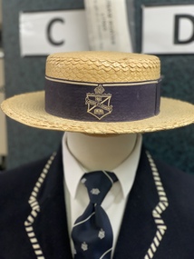 Mentone Grammar School
Boater, Summer Hat until 1971
-
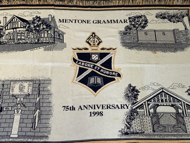 Mentone Grammar School
75th Anniversary Tapestry
Tapestry made for the School's 75th Anniversary celebrating four locations of significance on the campus of Mentone Grammar -
 Mentone Grammar School
Drinan Medal
Tony Drinan -
 Mentone Grammar School
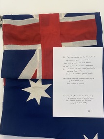
Flag (collection) - Australian Flag, The Kokoda Treck
This flag was carried over the Kokoda Treck by successive generations of Mentonians from 1993 to 2003. On each occasion, the party (which also included representatives from the AGSV and APS Schools) was led by the Reverend Roger Williams, the School Chaplain. The flag was presented to Mentone Grammar School by Rod Atkinson, M.P., Federal Member for Isaacs. It is noteworthy that in more than three decades of this educative mission to Papua New Guinea, Reverend Williams conducted over fifty such crossings of the Owen Stanley Range. The Kokoda Track or Trail is a single-file foot thoroughfare that runs 96 kilometres (60 mi) overland – 60 kilometres (37 mi) in a straight line – through the Owen Stanley Range in Papua New Guinea. The track was the location of the 1942 World War II battle between Japanese and Allied – primarily Australian – forces in what was then the Australian territory of Papua. Neville Clark, 2003 -
 Mentone Grammar School
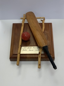
Award - Wood Carving, J.F. Scott Trophy for Inter-House Cricket
Miniature wood cricket bat and stumps, carved from an original cricket stumpJ.F. Scott Trophy for Inter-house Cricket