Showing 388 items
matching nepean
-
 Greensborough Historical Society
Photographic Slides, Watsonia High School Pool - Photo Slides 1968, 1976-1977
Records the development of the Watsonia High Pool at the Nepean Street Greensborough site during the years 1976-1977. The pool is still operational in 2019 as Yarra Swim School.Primary source material of the beginnings of the pool.36 Kodak slides of in Agfacolor box."Handwritten on box: Watsonia High 2-5-68 H.N." printed on slides: "Processed by Kodak - Ektachrome Transparency".watsonia high school, kodak slides, yarra swim school -
 Greensborough Historical Society
Photographic Slides, Watsonia High School - Photo Slides 1961 to 1964, 1961-1964
Records various events involving Watsonia High School from the very beginnings of the school at the Nepean Street Greensborough site during the years 1961 through to 1964.Actual record of student, staff and committee activities in the early 1960's.Approx 100 Kodak slides of WHS events in the early 1960s - includes 1961 Committee, 1962 Sports Events, 1962 Staff and individual Classes, 1962 and 1963 school excursions, 1964 Classes and eventsProcessed by Kodak using Kodachrome Transparency technology.watsonia high school, kodak slides -
 City of Kingston
Photograph - Black and white, c. 1930
During the 1930s Moorabbin was an area with open grasslands, still often used for market gardening. The development of the city (and, later, suburb) can be seen emerging from the railway station.The Nepean Highway is a major highway running through the City of Kingston. This image is one of many that depicts its importance to the local community as it undergoes many changes over time.Black and white photograph of aerial view of intersection of Nepean Highway and South Road. Moorabbin Council Chambers are situated on the corner with the library, old shire building, Moorabbin railway station, St David's Anglican Church market gardens and open paddocks in the background.White round sticker on reverse with black printed text: 143 Handwritten in red ink on reverse: 156% / k000786moorabbin, council, railway station, railway, suburbs, paddocks, nepean highway -
 City of Moorabbin Historical Society (Operating the Box Cottage Museum)
Functional object - Laundry Equipment, wooden double wash trough, c1900
c1900 This large wooden double wash trough with 'Acme' clothes wringer came from the old 'Exchange Hotel' now known as The Tudor Inn, Nepean Highway, Cheltenham.The Exchange Hotel, Point Nepean Road, Cheltenham, (now The Tudor Inn Hotel Nepean Highway,) was built in the late 1800s. By 1915 it was a prominent meeting place for early settler families of Moorabbin Shire. The trough is typical of those used in large laundries c1900 The ACME wringers were used in most households until c1960 Wooden, double washing trough, on a wooden stand c1900moorabbin, cheltenham, brighton, nepean highway, exchange hotel, the tudor inn hotel, clothing, early settlers, pioneers, market gardeners, acme manufacturing company, glasgow. -
 City of Moorabbin Historical Society (Operating the Box Cottage Museum)
Booklet - Eightieth Celebration of the Patronal Festival - St Matthew's Church Cheltenham - commemoration of the Dedication 1867-1947, 1947
St Matthew's Church of England was erected in Cheltenham beside the Nepean Highway near Charman Road. The early settlers established a tennis club, cricket team and social groups.St Matthew's Church of England Cheltenham was erected in 1867 and was integral to the spiritual well being and social life of the early settlers.Booklet on the history of St Matthew's Church, Cheltenhamst. matthew's church of england cheltenham, anglican church, early settlers, parish of moorabbin, city of moorabbin, county of bourke, shire of moorabbin, were j.b., market gardeners, cheltenham, charman road, nepean highway -
City of Moorabbin Historical Society (Operating the Box Cottage Museum)
Book - Pioneers of Faith - St Matthew's Cheltenham 1867 - 1992, by Sue Polites, 1992
St Matthew's Church of England was erected in Cheltenham beside the Nepean Highway near Charman Road. The early settlers established a tennis club, cricket team and social groups.St Matthew's Church of England Cheltenham was erected in 1867 and was integral to the spiritual well being and social life of the early settlers.Book about the history of St Matthew's Church, Cheltenham from 1867 to 1992. The book contains photos.st. matthew's church of england cheltenham, anglican church, early settlers, parish of moorabbin, city of moorabbin, county of bourke, shire of moorabbin, market gardeners, cheltenham, charman road, nepean highway -
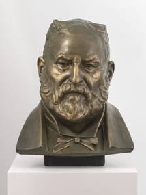 Bayside Gallery - Bayside City Council Art & Heritage Collection
Sculpture, Margaret Baskerville, Sir Thomas Bent, c. 1911
This work is a plaster maquette of a large bronze statue of politician and land speculator Sir Thomas Bent by Margaret Baskerville that is located on the corner of Bay Street and Nepean Highway, Brighton.Margaret Baskerville, Sir Thomas Bent c.1911, patinated plaster, 55 x 49 x 49 cm. Bayside City Council Art and Heritage Collection. Donated by Charles Douglas Richardson, 1931.patinated plaster thomas bent, politician, mayor, premier, bust, sculpture, margaret baskerville, land speculator, speaker, local government, councillor, member of lower house, portrait -
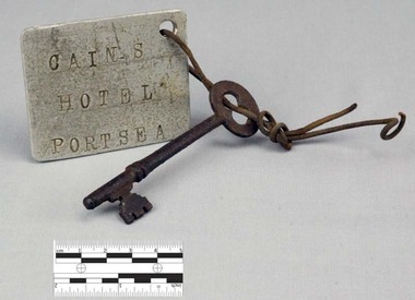 Nepean Historical Society
Functional object - Key with Tag
This object features a key with a labelled tag attached to it. It was once the key to the well-known Nepean Hotel. Also known locally as 'The Castle', likely due to its grand size and turret-like tower, the Nepean Hotel was officially established in 1872 by James Sandle Ford (https://poi-australia.com.au/points-of-interest/australia/victoria/portsea/approximate-site-ford-family-nepean-hotel-c-1870-pt-nepean-rd-near-fitzjohns-crt-portsea-mornington-peninsula-vic/). Born in 1811, Ford was only nineteen years old when he was sentenced to seven years transportation for 'Machine Breaking' in 1830. (https://nepeanhistoricalsociety.asn.au/james-sandle-ford/). He arrived in Van Diemen's Land (Tasmania) in 1831 and served five years of his sentence, before being pardoned in 1836. Ford met and married Irish immigrant Hannah Sullivan in 1841 in Sydney. The following year, the couple settled in Point Nepean. Ford is often accredited with the naming of the town of Portsea - after Portsea in Hampshire, UK - and spent a lifetime establishing himself throughout the area. This included: lime burning, dairying, horse judging and breeding, and the cultivation of land and livestock. Ford died in 1890, however his hotel continued to operate for many decades, run by his descendants - including Julia Cain during the first half of the twentieth century (https://trove.nla.gov.au/newspaper/article/65817831) (https://trove.nla.gov.au/newspaper/article/3734533). The hotel was demolished in 1971. This object is significant as it is important in relation to the development and prosperity of the area of Point Nepean. A door key with a rusted surface. One end of the key features a single set of teeth with three notches. Attached to the other end is a rounded handle with a hole through the middle. Looped through the hole is a piece of thin, rusted wire. The wire is looped through both the key and a hole in a white square-shaped tag. Printed on the tag are the words: 'CAIN'S HOTEL PORTSEA'. CAIN'S HOTEL, PORTSEAnepean hotel, cain family, james ford, james sandle ford, portsea hotel -
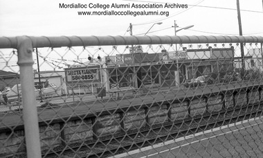 Mordialloc College Alumni Association Inc (MCAA)
Photograph, 1981 - Aspendale Station photographed from Station Street
Photograph depicts shops on Nepean Highway side of Aspendale Station - Siesta Marine, the pin-ball parlour, Velo’s hairdresser/barber and The Coq au Vin Restaurant corner Foster Streetaspendale shops -
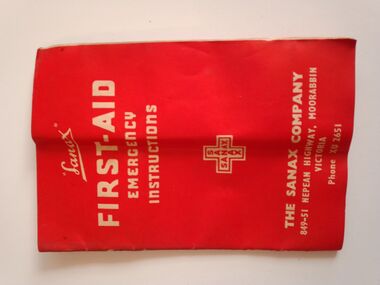 Warrnambool RSL Sub Branch
Equipment - WW2 Field Medical Kit- contents, part of, Sanax FIRST AID EMERGENCY INSTRUCTIONS Booklet
Small booklet, 23 pages. Red Cover of thin cardFront Cover: Sanax FIRST AID EMERGENCY INSTRUCTIONS. THE SANAX COMPANY 849-51 NEPEAN HIGHWAY MOORABIN VICTORIA. Phone XU2651 Inside Pages: first-aid treatment instructions and advertising of Sanax products -
 Greensborough Historical Society
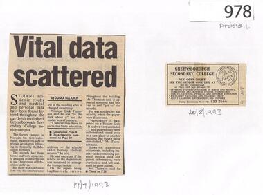
Newspaper Clippings, Diamond Valley News, Vital data scattered / Outrage at littered documents, 19/07/1993
Following the sale of Greensborough Secondary College's Nepean Campus site, student files, academic records and medical data were found scattered in the building. Article 2 interviews past students about the records.2 newspaper articles, text and images.greensborough secondary college, nepean campus -
 City of Moorabbin Historical Society (Operating the Box Cottage Museum)
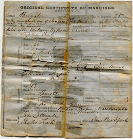
Certificate - Certificate of Marriage for Stephen Tuck & Catherine Draper, 1857
Stephen Tuck was one of the original settlers of the district, he had a market garden on Nepean Highway, Cheltenham. The family continued the market garden for over 70 years. It was subdivided and sold as residential blocks in 1940. Original Marriage Certificate of Stephen Tuck and Catherine Draper, in Moorabbin on 19 January 1857.stephen tuck, cheltenham, market gardens, city of moorabbin, land sales, marriage, catherine draper -
 Mordialloc College Alumni Association Inc (MCAA)
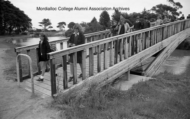
Photograph, 1985 - Mordialloc-Chelsea High School students cross the newly completed footbridge
The footbridge finally linked either side of a Mordialloc Creek so that students no longer had to cross over the Nepean Highway bridge. This enabled a safer and quicker journey for many pupils living north of the school.Image digitised from negativemordialloc creek, foot bridge -
 City of Kingston
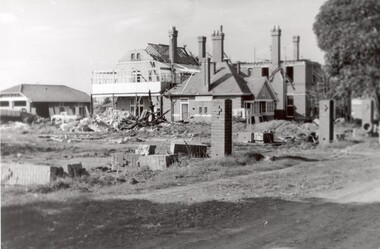
Photograph - Black and white, c. 1965
The St John of God Home for Disadvantaged Boys was located on Nepean Highway Chletenham, and was previously known as the Methodist Children's Home. It opened in approximately 1953 and was later demolished to make way for Southland Shopping Centre. The Brothers of St John of God were a Catholic order that first arrived in Australia in 1947, establishing their first school for boys with learning difficulties. They soon acquired 20 acres in Cheltenham in 1953, which became home to 100 boys and young men who could no longer live with their familiesBlack and white image of a demolition site where the St John of God Home for Disadvantaged Boys once stood. Buildings are visible behind the boys' home site, although also slated for demolition.Black printed text on white round sticker on reverse: 231 Handwritten in red ink on reverse: 95%religion, cheltenham, orphanage, boys home -
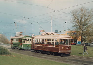 Melbourne Tram Museum
Photograph - TMSV tour trams 217 & 164, Keith Stodden, 13/6/1988
Photographs show trams S164 and X 217 on a TMSV tour 13/6/1988 at Haymarket junction (Royal Parade and Flemington Road, Elizabeth St) and the East Brighton (Hawthorn Road and Nepean Highway) Yields information about TMSV toursSet of two colour prints.tramways, trams, tmsv, tours, haymarket, east brighton, tram 217, tram 164 -
City of Kingston
Photograph - Black and white, 20 December 1945
This aerial image covers a section of Cheltenham, with a large paddock yet to be converted to an industrial and later a commercial zone.This aerial photograph provides evidence of the changing landscape of Cheltenham and Highett since WWII. Photographed in 1945, the image features a large block of land now the site of site the major transformation of Cheltenham with the development of the Southland shopping centre in the 1960s and expansion in the 1990s.Aerial photograph of the Cheltenham area in the City of Kingston. This 1945 image is concentrated on the area between Bay Road and Garfield Lane with the distinctive bend into Jean Street. A large block of land runs between the Nepean Highway and the rail line. This is now the area occupied by the extension of Southland in the 1990s.cheltenham, southland, aerial photograph, highett -
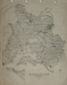 Federation University Historical Collection
Plan, Mornington, 1926, 1926
Printed plan on papermornington, phillip island, western port bay, bass straight, wonthaggi, lang lang, sherwood, nepean, narre worran, ringwood -
City of Kingston
Photograph - Black and white, 20 December 1945
This aerial image covers a section of Cheltenham, with a large paddock yet to be converted to an industrial and later a commercial zone.This aerial photograph provides evidence of the changing landscape of Cheltenham and Highett since WWII. Photographed in 1945, the image features a large block of land now the site of site the major transformation of Cheltenham with the development of the Southland shopping centre in the 1960s and expansion in the 1990s.Aerial photograph of the Cheltenham area in the City of Kingston. This 1945 image is concentrated on the area between Bay Road and Garfield Lane with the distinctive bend into Jean Street. A large block of land runs between the Nepean Highway and the rail line. This is now the area occupied by the extension of Southland in the 1990s. It is a negative version of VKHC124.cheltenham, southland, market garden -
 Bayside Gallery - Bayside City Council Art & Heritage Collection
Photograph, Department of Crown Lands and Survey, Victoria, Brighton, Brighton East and Bentleigh, c. 1965-71
The Department of Crown Lands and Survey (1857-1983) was responsible for the administration of survey and mapping and the sale, occupation and management of crown land throughout its existence. This aerial photograph shows parts of Brighton and Brighton East and was taken circa 1965-71.brighton, department of crown lands and survey, aerial photograph, bayside, port phillip bay, map, cartographic material, brighton east, dendy park, dendy street, centre road, nepean highway, south road, brighton golf course, golf -
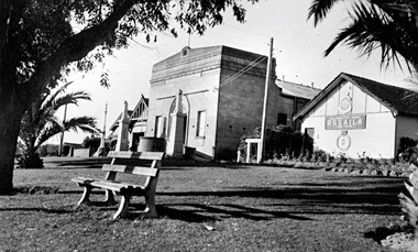 City of Kingston
Photograph - Black and white, c.1945
This photograph shows the Protestant Hall on Nepean Highway Cheltenham, which at the time of the photograph was used by the Returned Sailors' Soldiers' and Aimen's Imperial Leage of Australia (RSSAILA). The building facade, World War I memorials, fire station building and road plantation are also in view. The Protestants Hall was built by the Cheltenham Protestant Hall Company Limited in 1886. The hall has been used for a wide variety of purposes; in earlier times it served as the Sunday School for the Methodist Home for Children, and later as a schoolhouse when the Beaumaris School (now Cheltenham State School) No 84 met with overcrowding problems. It was also a popular venue for annual balls and regular dances held by church groups and sporting organisations. The City of Moorabbin purchased the building in the 1920's for use by the Returned Soldiers and Sailors League, in whose hands it remained until the late 1970s when it was taken over by a catering firm. During the 1920s, and right up to the late 1950s, it also served as Cheltenham's picture theatre. The three memorial columns, one from the South African War, one from World War I and one from World War II previously located in front of the hall were relocated when Nepean Highway was widened. The Protestant Hall still stands at 1261 Nepean Highway CheltenhamBlack and white digital image depicting three buildings. The right hand building bears a sign that reads RSSAILA. There are trees and a bench seat in the foreground. There is a World War I memorial pictured. world war i, world war ii, protestant hall, cheltenham, returned sailors' soldiers' and aimen's imperial leage of australia (rssaila), returned and service's league (rsl) -
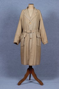 Brighton Historical Society
Coat, Dustcoat, c.1948
Dust coat worn by Mr Frederick Alister Jennings when he managed a family grocery store circa 1948 at 510 Point Nepean Road, East Brighton. Frederick was born at Nagambie, Victoria in 1909 and died in Brighton in 1979. He was the son of Hugh Edwin Jennings and Alice Constance Warren. He married Margaret Jean Hughes in 1934 and served in the Second World War. He lived at 1 Valda Grove Brighton. Frederick was a commercial traveller as well as his time spent managing the store in Point Nepean Road. It is believed this coat dates from his time at the store c1948 - 1955. The store was owned for many years by his father-in-law W. G. Hughes and was one of a group of shops near the corner of Centre Road. In 1944-45 the group of shops included Fletcher’s fuel merchants, a haberdasher, butcher, fruiterer, grocer, Brighton East post office, a ladies’ hairdresser and Hughes’ grocer. In 1950 Hughes’ grocery store was between a service station and the Commercial Bank on what had been renamed Nepean Highway. The business was sold to G. S. Maynard, grocer, sometime before 1960.Unlined dustcoat of beige cotton. Fastens centre front with three brown plastic buttons. Two large patch pockets. Separate cloth belt with metal buckle. Signs of wear and mending. .1 - coat .2 -beltGarment label reads: APEX (RLG.) Dust Coat DEPT. MYER STORE for MEN. MELBOURNE & ADELAIDEdustcoat, occupational dress, grocer, hughes grocery store, brighton, frederick alister jennings -
City of Moorabbin Historical Society (Operating the Box Cottage Museum)
Booklet - Church of St Matthew Cheltenham Souvenir Diamond Jubilee (of current building) 1867 - 1927, 1927
St Matthew's celebrated it Silver Jubilee in September 1927 with Church Services and social gatherings, a concert, a social and a dance. St Matthew's Church of England was erected in Cheltenham beside the Nepean Highway near Charman Road. The early settlers established a tennis club, cricket team and social groups.St Matthew's Church of England Cheltenham was erected in 1867 and was integral to the spiritual well being and social life of the early settlers.Souvenir booklet of text and pictures produced for the Diamond Jubilee for the St Matthew's Church of England, Cheltenham - 18 pagesst. matthew's church of england cheltenham, anglican church, early settlers, parish of moorabbin, city of moorabbin, county of bourke, shire of moorabbin, were j.b., market gardeners, cheltenham, charman road, nepean highway -
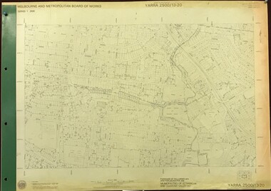 Greensborough Historical Society
Map, Melbourne and Metropolitan Board of Works. Survey Division, MMBW, Yarra 2500 / 13.20. Greensborough, Montmorency and Watsonia, 1979_03
Melbourne and Metropolitan Board of Works. Yarra 2500 [base map] 13-20. Greensborough, Montmorency and Watsonia. Parishes of Nillumbik 3310 and Keelbundora 2856. Municipalities of Eltham 238 and Diamond Valley 257. Prominent streets include: Nell Street, Nepean Street and Alexandra Street. Includes Montmorency High School.MMBW Map in 1:2500 [scale] series. Cream parchment with green tape reinforcing on edges and punched holes on left edge.mmbw, melbourne and metropolitan board of works, shire of diamond valley, greensborough - maps, montmorency - maps, watsonia - maps -
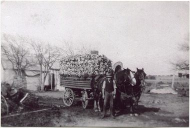 City of Moorabbin Historical Society (Operating the Box Cottage Museum)
Photograph, Black & White, V Peterson East Boundary Rd East Bentleigh loaded wagon c1900, original c1900
The Peterson family were early settlers in Moorabbin Shire and established a market garden in East Boundary Road East Bentleigh. Vic Peterson and family loaded the crop - cabbages - onto the horse drawn wagon and set off to the Melbourne market using the Plateways that ran along Centre Road and Nepean Highway. The early settlers like the Petersons , in the Parish of Moorabbin County of Bourke after Henry Dendy's Special Survey Brighton 1841, established market gardens, fruit & flower gardens, poultry & dairy farms, vineyards as well as shop businesses, blacksmiths, chemists, nursing homes and schools & Churches.Black & White photograph showing Vic Peterson beside the horse drawn wagon loaded with 35dozen ( 12x 35) cabbages setting off to market c 1900 Original re-digitised by H Stanley 2005Back Hand written informationwagons, vulcan trucks, draught horses,, peterson vic, marriott dick, cabbage crops, vegetable crops, poliomyelitis epidemics 20thc , elster creek, plateways moorabbin shire, smith j l; smith mary ann, stanley helen, smith vic, smith harry redvers, chaff cutter, horse drawn carts, toll gates brighton, motor cars 1900, steam engines, early settlers, bentleigh, mckinnon, parish of moorabbin, city of moorabbin, county of bourke, moorabbin roads board, shire of moorabbin, henry dendy's special survey 1841, were j.b.; bent thomas, o'shannassy john, king richard, charman stephen, highett william, ormond francis, maynard dennis, market gardeners, vineyards, orchards -
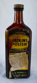 City of Moorabbin Historical Society (Operating the Box Cottage Museum)
Domestic object - Watkins Polish, J. R. Watkins Co (USA), 20thC
The J. R. Watkins Co. opened its first overseas branch in Australia in 1935. The J. R. Watkins built a large factory at Highett on a six acres on the east side of Nepean Highway (no. 1123) in 1954. The J. R. Watkins company was founded in 1868 in Plainview, Minnesota USA, moving to Winona in 1885, by J. R. Watkins.Example of industry in the City of Moorabbin.Amber glass bottle with a metal screw on lid. A paper label is on the front of the bottle 'Watkins Polish" printed in yellow, black and white.PRINTED ON LABEL: 11 Fluid ounces - WATKINS POLISH - Gives a hard dry lustre excellent for Dusting For cleaning, dusting and polishing furniture, pianos, woodwork, linoleum, hardwood floors and all polished surfaces. Directions: If the article to be polished is dirty or gummy, clean it by washing with mild soap and warm water. Apply Watkins Polish with a damp, soft cloth (Dampened with water and wrung almost dry). The Polish may be poured on the damp cloth or on the surface to be polished. In either case rub it all with a dry cloth to obtain a high polish. When dusting, dampen the cloth with Watkins Polish - it keeps down the dust and gives a lustre which is neither greasy not gummy. The J. R. Watkins Co. Melbourne - Sydney - Adelaide - Kogarah EMBOSED ON BOTTLE: "The J.R.Watkins co. Made in Australia" the j. r. watkins co, highett, polish -
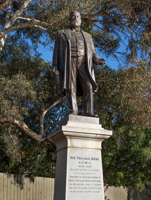 Bayside Gallery - Bayside City Council Art & Heritage Collection
Sculpture, Margaret Baskerville, Sir Thomas Bent, 1913
Arguably Margaret Baskerville’s most famous work, the bronze statue of politician and land speculator Sir Thomas Bent was Baskerville’s first public commission and a significant turning point in her career. Originally located in the centre of the Nepean Highway, in Brighton, it became somewhat of signpost for many Melbournians until it was relocated to the corner of Bay Street in 1980.The statue of Sir Thomas Bent is of historic and social significance to the State of Victoria. The statue is historically significant for commemorating Bent's long, active and infamous political career in Victoria. He was responsible for many important speculative ventures both within his electorate and in the wider context of Victoria. Although not without thought for personal gain, Bent was a committed advocate of public utilities, railways, roads, tramways and gasworks. The statue is historically significant as the first large public commission given to a woman sculptor in Victoria. This work helped the sculptor, Margaret Baskerville, preserve her name as Victoria's first professional woman sculptor. The statue is socially significant as testimony to the late nineteenth century land boom and the financial and political corruption and scandals that accompanied it. https://vhd.heritagecouncil.vic.gov.au/places/12614bronze and granite thomas bent, politician, mayor, premier, bust, sculpture, margaret baskerville, speaker, member of parliament, member of lower house, local government, councillor, brighton, public art, bayside -
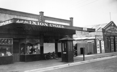 City of Kingston
Photograph - Black and white, c. 1940
Black and white image featuring Mr Whalebone's bicycle shop, the post office and the Poultry Auction Centre along Nepean Highway, Moorabbin. In front of the shops is a telephone booth. There is a bike leaning against the front window of the post office and between the post office and the poulty auction shop is a picket fence with a gate, and two boys are coming through the gate, one of them wheeling a bike.Black printed ink on a round white sticker on reverse: 160 -
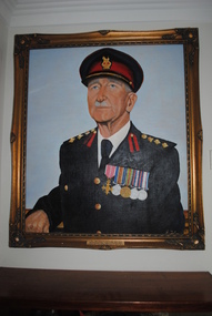 Anglesea and District Historical Society
Portrait, James Foley, Col. John Purdue O.B.E
Oil portrait of Col. John Purdue O.B.E. in full army uniform with 5 campaign medals on left breast painted on canvas stretched over hardboard in ornate gilt wooden frame.Plaque affixed to bottom of frame reads: COL. JOHN PURDUE O.B.E. 24-5-1890/25-3-1980. / FIRED THE FIRST SHOT IN W.W. I FROM FORT NEPEAN ACROSS BOW OF / GERMAN STEAMER "PFALZ' MERCHANT RAIDER ON AUG 5 - 1914 AT 12.50 PM.purdue, j foley, ww1, "pfalz" -
City of Kingston
Photograph - Black and white, 5 January 1984
Cheltenham and Heatherton are suburbs in the City of Kingston that were originally established as a rural market gardening community. The market gardens, farms and paddocks have gradually been sub-divided into housing and industrial estates and associated infrastructure such as schools and shopping facilities. This aerial image covers a diverse section of the City of Kingston, taking in the suburbs of Cheltenham, Heatherton, Mentone and Parkdale. By 1984, the market gardens of the district have been replaced by housing and factories. The Nylex factory is visible and now closed. Mentone Bowl on the corner of Warrigal Road and Nepean Highway has now been replaced by high rise apartments, another feature of the changing landscape in the City of Kingston. The vacant land now occupied by the Moorabbin Airport Direct factory Outlet (DFO) is also depicted.Aerial photograph of Cheltenham, Heatherton, Mentone and Parkdale within the City of Kingston. The area depicted in the 1984 aerial view includes Centre Dandenong Road and Cheltenham East Primary School (top left), Kingston Heath Reserve (top right), intersection of Lower Dandenong Road, Warrigal Road, Balcombe Road and Nepean Highway (bottom left), Balmoral Drive/McSwain Street Parkdale (bottom right).White text: 3831-179 Lens information [indecipherable] RINGWOOD M/S 7922-3 RUN 16 [Clockface image] 5,300' ASL VIC DLS© 5-1-84cheltenham, heatherton, mentone, parkdale, market gardens, urbanisation -
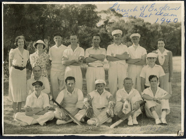 City of Moorabbin Historical Society (Operating the Box Cottage Museum)
Photograph, Black & White, St Matthew's Church of England Cricket Team c 1940, c1940
The Cheltenham parish was created in 1865 by excising a portion of the parish of St Andrews Brighton. A small brick church was completed in 1867 to serve a rural community stretching from Brighton South (Moorabbin) to Mordialloc. 1867 St Matthew's Church of England was erected in Cheltenham beside the Nepean Highway near Charman Road. The early settlers established a tennis club, cricket team and social groups.St Matthew's Church of England Cheltenham was erected in 1867 and was integral to the spiritual well being and social life of the early settlers.Black & White photograph of the St Matthews Church of England Cricket team Cheltenham c 1940Front ; Church of England Cricket Team 1940 Back ; Written - Ladies / Hilda Biehl, Bertha Schneeberber, Mrs Wootton, / We made afternoon tea from / a kerosene tin for 30 players / each Saturday they played at home !!smith j l; smith mary ann, stanley helen, chaff cutter, horse drawn carts, toll gates brighton, motor cars 1900, steam engines, early settlers, bentleigh, parish of moorabbin, city of moorabbin, county of bourke, moorabbin roads board, shire of moorabbin, henry dendy's special survey 1841, were j.b.; bent thomas, o'shannassy john, king richard, charman s, highett william, ormond francis, maynard dennis, market gardeners, vineyards, orchards,