Showing 3199 items
matching railways history
-
 Parks Victoria - Maldon State Battery
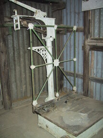
Scales, platform
... relocated from the nearby Maldon Railway station. The history of its... Historic Area Maldon goldfields Similar to railway platform scales ...Similar to railway platform scales and may have been relocated from the nearby Maldon Railway station. The history of its use at the battery is unknown.Large cast iron platform scale, white painted base with 2 wheels. The cast iron plate sits on top of a base with an inscription. There is white and green floral decoration on the frame, which is attached to the base. The white decorative stand with tray and weight measure attached has an inscription.base- "W. & T. Avery Ltd/makers/London &/Birmingham". Platform- "W. & T. Avery Ltd. Weight measure- LB 14 12 10 8 6 4 2" -
 Puffing Billy Railway
Sign - Puffing Billy Museum Entry
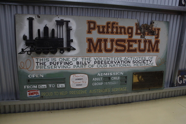
... that Victorian narrow gauge railway history was quickly being destroyed...Puffing Billy Railway 1 old monbulk road Belgrave yarra ...The Museum was first considered in 1963 when it was felt that Victorian narrow gauge railway history was quickly being destroyed by progress. Originally it was planned to only cater for two locomotives and some rolling stock associated with the Moe and Walhalla Railway. Construction of the site commenced on Labour Day Weekend in March 1964, the area was then fenced. The first exhibit arrived soon after and companies with locomotives and other railway features offered items to the Museum. When interesting exhibits from the "Steam Era " were known to be coming available,discussions were held with the owners in an attempt to obtain the item for preservation. In 1965 an Umbrella style shed was built and by May, the first locomotive ex Erica State Saw Mill (CLIMAX) had arrived. The Museum was opened to the public in November 1970 but was officially opened by His Excellency the Governor of Victoria, Sir Rohan Delacombe on Saturday 7th April 1973.Historic - Puffing Billy Museum Entry SignPuffing Billy Museum Entry Sign Rectangular hand painted sign in use from 1970.Puffing Billy Museum This is one of the Volunteer activities of The Puffing Billy Preservation Society Preserving part of our National Heritage Proud to Help Preserve Australia's Heritage puffing billy, menzies creek, sir rohan delacombe, narrow gauge, steam -
 Surrey Hills Historical Society Collection
Digital photo, George L Coop, Surrey Hills railway station, October 1958, October 1958
... of his documentation of railway history in other collections... of railway history in other collections contributing to this database ...Trains with electric swing doors were often referred to as "dog boxes" or "doggies". They were manufactured at the Newport Workshops for the Victorian Railways. Swing Door cars had outward-opening doors. They were reasonably narrow, to ensure that two passing trains would not foul each other if doors were accidentally left open. The donor George Lister Coop was about 21 years of age when he took this photo. He advised that in order to access this point he had to scramble through a bit of rough undergrowth and beginnings of a car park. All near an open drain of some kind. It is one of a small series of photos donated by him that relate to Mont Albert and Surrey Hills stations. George has always had an interest in railways and there are other examples of his documentation of railway history in other collections contributing to this database. A black & white photo of a swing door train destined for Flinders Street that is within the platforms at Surrey Hills. The photo is taken from the western end of Surrey Hills Station. There is a man near the end of the platform on the north side. He is probably a railway worker heading towards his work shed just seen on extreme left. george l coop, railway stations, swing door trains, trains -
 Wodonga & District Historical Society Inc
Article - Fred Rochow Railways Collection - George Lynch Senior, C. 1950s
... Street to Albury. He made railway history in 1937 when the Sydney... railway history in 1937 when the Sydney Ltd ran non-stop from ...The Fred Rochow Railways Collection incorporates photos related to the operation of the Wodonga Railway Station including different types of trains and railways staff C. 1930 – 1990. It was donated to the Wodonga Historical Society by Fred Rochow, a railwayman who spent many years based in Wodonga. He joined the Victorian Railways on 17th June l947 and retired in 1988. For some time, he was a member of the Australian Federated Union of Locomotive Enginemen and served a term as a member of the Trades Hall Council. He had an extensive knowledge of the struggles that took place to achieve better conditions for railway workers. Fred worked for many years as a fireman and then worked his way up the ranks to driver, experiencing many changes from the days of steam locomotives through to diesel trains, locomotives and even the modern XPT train. He worked throughout Victoria at different stages of his career, with his final working years focused on the northeast of Victoria and the Albury to Melbourne line. After his retirement, Fred continued to share his love of steam miniature trains with the community.This collection has local and statewide significance as it captures images of trains, locomotives and personnel who operated the railway services in Wodonga and throughout Northeast Victoria. The railways played a critical role in opening up Victoria and connecting Australia for trade, business, social communication and transport.George Lynch had a long career with Victorian Railways. The son of a railway man, George grew up in St Arnaud near the railway line. He watched the engines go by and dreamed of being an engine driver. He started working as a cleaner in 1907. Through hard work and further study, George worked his way up to become a locomotive driver. He moved to Wodonga in 1917. At the Victorian Railways Institute examinations, George won four gold medals for Engine Working and Westinghouse Brake In 1925 he was appointed as an Instructor. George was one of four senior drivers who in rotation drove the Sydney Limited. The other drivers were Ray Murphy, F. Hobbs and George Padgett. They all lived with their families in Wodonga. George drove the first Spirit of Progress from Spencer Street to Albury. He made railway history in 1937 when the Sydney Ltd ran non-stop from Albury to Spencer Street in 3 hrs. 25 mins, clipping 25 minutes off the previous record. He retired at the age of 65 in 1953 and died at the age of 74.railways wodonga, fred rochow, wodonga railwaymen, george lynch snr -
 Port Melbourne Historical & Preservation Society
Audio - PMHPS Meeting, Allan French and Ian Jenkin, Australian Railway Historical Society, 27 Aug 2004
... the Australian Railway Historical Society. The history of the Hobsons... the Australian Railway Historical Society. The history of the Hobsons ...Recording of PMHPS Meeting on 27.08.2004. Recording done at Port Town Hall. Speakers were Allan French and Ian Jenkin from the Australian Railway Historical Society. The history of the Hobsons BayRailway (Sandridge/Port Melbourne) Recording duration 47:09transport - railways, allan french, ian jenkin, hobsons bay railway -
 Wodonga & District Historical Society Inc
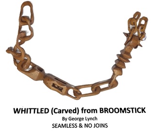
Decorative object - Whittled artefact, George Lynch
... railway history in 1937 when the Sydney Ltd ran non-stop from... railway history in 1937 when the Sydney Ltd ran non-stop from ...This item was whittled as a continuous piece from a broomstick handle by George Lynch. George had a long career with Victorian Railways. The son of a railway man, George grew up in St Arnaud near the railway line. He watched the engines go by and dreamed of being an engine driver. He started working as a cleaner in 1907. Through hard work and further study, George worked his way up to become a locomotive driver. He moved to Wodonga in 1917. At the Victorian Railways Institute examinations, George won four gold medals for Engine Working and Westinghouse Brake In 1925 he was appointed as an Instructor. George was one of four senior drivers who in rotation drove the Sydney Limited. The other drivers were Ray Murphy, F. Hobbs and George Padgett. They all lived with their families in Wodonga. George drove the first Spirit of Progress from Spencer Street to Albury. He made railway history in 1937 when the Sydney Ltd ran non-stop from Albury to Spencer Street in 3 hrs. 25 mins, clipping 25 minutes off the previous record. He retired at the age of 65 in 1953 and died at the age of 74.This item is significance because it was made by a long-serving locomotive driver based in Wodonga.A chain made by whittling the handle of a broomstick. It is one continuous piece of wood with a variety of shapes swivels and interlinked sections. There are 13 similar sized links and 2 larger ones. The larger links have small balls inside them.whittled objects, george lynch, railways wodonga -
Whitehorse Historical Society Inc.
Article, History shown in bold picture, 1983
... service between Vermont and Mitcham Railway station. A brief... between Vermont and Mitcham Railway station. A brief history ...A brief history of the Willis Bus Service is given.A photo had been found at the Willis Bus service headquarters in Vermont which shows a gathering of Vermont residents about 1923 at the launching of a publicly subsidised bus service between Vermont and Mitcham Railway station. A brief history of the Willis Bus Service is given.A brief history of the Willis Bus Service is given.vermont, willis bus service, armstrong, norman, willis, jim, willis charles l, vermont progress association -
 Ballarat Tramway Museum
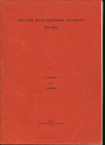
Book, J.C.Radcliffe & C.J.M.Steele, "Adelaide Road Passenger Transport 1836-1958", 1974
... history, railways, horse buses and trams, electric trams, buses.... Contents include Adelaide history, railways, horse buses and trams ...A4, 208 page book, soft cover bound, on public road transport in Adelaide, 1836 to 1958. Contents include Adelaide history, railways, horse buses and trams, electric trams, buses, trolley buses, social history and tram closure. Has 23 pages of photographs. Also has contents, references, maps and an index. Bound with red card covers. Written by J.C.Radcliffe and C.J.M.Steele.Inside front cover in black ink "Neville M.Gower / Greenacres / Sth. Australia"trams, tramways, adelaide, tramways, transit systems -
 Bendigo Historical Society Inc.
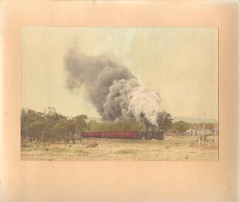
Photograph - MALDON RAILWAY. TWO STEAM TRAINS
... , Railway Preservation Society'. History: With note 'Photographs... Inc. History House 11 Mackenzie Street Bendigo goldfields ...Hand tinted colour photograph of two steam trains belching smoke. Passenger carriages on near train. Spectator of left centre. Small cottages on right hand side. Inscriptions: on back - stamped BR 'Frank T Kennedy'. Hand written - 'Maldon Railway, Railway Preservation Society'. History: With note 'Photographs from Mrs Ella Bourke, 131 Barnard St, Bendigo, Ph 43 8269.Frank T Kennedytopic, objects, trains -
Port Melbourne Historical & Preservation Society
Flyer, Victorian Railways, Sandridge Rail Trail, 2005
... in background. Fold out section has history of railway, map, walk... transport - railways recreation piers and wharves - station pier ...Fold out flyer with black and white picture of train and three men on front cover. Back cover coloured image from Latrobe picture collection of park-like setting with steam train in background. Fold out section has history of railway, map, walk and ride descriptionstransport - railways, recreation, piers and wharves - station pier, piers and wharves - railway pier, hobson's bay railway company, melbourne and hobson's bay united railway company, montague street station, golden fleece hotel, st barnabas anglican church, north port station, lord raglan hotel -
Unions Ballarat
WJ McAdam: "Labor Memoirs, Ballarat", William J McAdam, circa 1960s
... ": #Ballarat North Railway Workshops History #Preferential voting..., Ballarat. "Labor Memoirs, Ballarat": #Ballarat North Railway ...W.J. McAdam was a former union organiser (Ballarat Municipal Employees section of the Shop Assistants and Textile Workers Union). He is a past president and secretary (on two occasions) of Trades Hall, Ballarat. "Labor Memoirs, Ballarat": #Ballarat North Railway Workshops History #Preferential voting at elections #History of the White Swan Dam Project (1 vol) The White Swan Dam was completed in the 1950s. Ballarat North Railway Workshops were opened in 1917 after political pressure to decentralise railway workshops. The White Swan Dam was completed in the 1950s. Ballarat North Railway Workshops were opened in 1917 after political pressure to decentralise railway workshops. Relevant to Ballarat employment opportunities, history of preferential voting and history of the White Swan Dam Project. 2017 is the centenary of this important outcome for the City of Ballarat. Paper (1 volume) btlc, ballarat trades hall, ballarat trades and labour council, wj mcadam, labor memoirs, preferential voting, elections, white swan dam project, textiles, textile, clothing and footwear union, white swan reservoir, railways, voting, ballarat north railway workshops -
 Bendigo Historical Society Inc.
Document - RAILWAYS COLLECTION: BENDIGO RAILWAY WORKSHOPS - A SHORT HISTORY
... RAILWAYS COLLECTION: BENDIGO RAILWAY WORKSHOPS - A SHORT... part document titled ''Bendigo railway workshops - A short... railway workshops - A short history''. The second Bendigo ...School project by Jillian Bovaird in four parts. First part document titled ''Bendigo railway workshops - A short history''. The second Bendigo workshops ''News and Views'' newsletter from 5 March 1987. the third Seven - O - seven operations Inc. The fourth Brochure of V/Line Bendigo workshops open day.bendigo, railways, bendigo railways -
 Melbourne Tram Museum
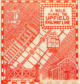
Pamphlet, Brunswick Community History Group, "A walk along the Upfield railway line", 1993
... , centre stapled titled "A walk along the Upfield railway line... railway line", outlining the history of the line, dates, hand ...Pamphlet or small booklet, 12 pages on recycled paper, centre stapled titled "A walk along the Upfield railway line", outlining the history of the line, dates, hand operated gates, Royal Park to Brunswick, cable trams and the Sarah sands, sketches, The Jewell, map, Brunswick Station, grain stores, substation, Brunswick tram depot, sidings and railway signals. Published by the Brunswick Community History Group in 1993In ink page 3 "KS 8-7-94"trams, tramways, upfield, brunswick, railways, level crossings -
Bendigo Historical Society Inc.
Document - SPECIMEN COTTAGE COLLECTION: VARIOUS DOCUMENTS
... and business. 2. The history of the Bendigo Railway and memoirs... and business. 2. The history of the Bendigo Railway and memoirs ...Various documents in plastic folders. The topics are: 1. The Myer story - articles on the history of the Myer family and business. 2. The history of the Bendigo Railway and memoirs of early train travel by Bob Carr. 3. Victorian history of railway and Bendigo, linking a state. 4. A brief history of steam locomotives R711 and R766. 5. Bendigo Advertiser article: coming of the railway with 4 photos. 6. Celebrating 150 years of rail in Bendigo brochure plus postcard and Bendigo Railway Museum newsletter. 7. Phoenix FM radio interview 13th September 2011. interviewer John Hall, guest: Garry Long, Convenor friends of the Bendigo-Kilmore rail trail. 8. Mail by rail by Tom Luke and Railway history Leo Hogan. 9. Document on the Red Ribbon Movement. 10. Document - Sport in Bendigo in the early days. 11. History of the Girton Church of England Girls' Grammar School with a list of prominent students. 12. Bendigo's loss-Chinese secret society's gain? Talk given by Carol Holsworth. 13. Document - Bendigo in the fifties. 14. Jones, Miller & Co. history. 15. Transcript of an audio tape by Cyril Michelsen, black and white photo and newspaper article. 16. A garden history by Ken Maes. 17. Document - Marsh and Scholten Coach builders. 18. Notes from the diary of Thomas Ninnes, newspaper articles on the restoration of the Ninnes grave. 19. Sandhurst 1853-54 The Southern world Rev. Robert Young. 20. Correspondence from Cobb & Co. Royal Flying Doctor Service 1963 coach run and the 1963 coach run itinerary. 21. Various newspaper clippings on Rosalind Park. 22. Rosalind Park discovery walk brochure and heritage mosaic Rosalind Park lookout brochure. 23. Camp Reserve, Rosalind Park, used and abused by James Lerk, also newspaper articles by James Lerk about Rosalind Park and various other documents relating to the Park. 24. Rotary Club History - A bulletin from 1971 and two cards in the name of Albert Richardson. 25. History Lives: Bendigo east's Anzac Avenue photographs and documents. 26. Short biography of John Walker. 27. Restoring our heritage - The Beehive story. 28. Documents about the Bendigo Advertiser, including historical notes by Carol Holsworth and notes given in 2005 by Leanne Younes. 29. Document - National Trust of Australia: City of Bendigo abattoirs (form, 47 Lansell Street. 30. The Alexandra Fountain by Lucy Williams also newspaper clippings and a document from the RHSV. 31. Newspaper clippings and correspondence on the demolition of the A.N.A. building. -
 Melbourne Tram Museum
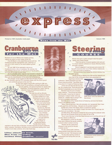
Newsletter, The Met, Public Transport Corporation, "Express - News from The Met - Autumn 1995", "Express - News from The Met - Summer `1995/96" and Autumn 1996", March 1995 to Autumn 1996
... , punctuality, history dates, railways, CSE's and a list of Melbourne... Railways W Class Buses Fares Police Security Franklin St Victoria ....1 - Newsletter, large format, special size titled "Express - News from The Met - Autumn 1995", four pages. Has stories about the Cranbourne electrification, female traffic staff on the buses and trams, refurbishment of W class trams, METROL, punctuality, history dates, railways, CSE's and a list of Melbourne events. .2 - as above - Express - News from The Met - Summer `1995/96" - rail timetable changes, night rider buses, police, fares and a list of Melbourne events. .3 - as above - Express - News from The Met - Autumn 1996"- Grand Prix, Franklin St terminus replaced by Melbourne University Superstops, railway power supply and a list of Melbourne events.trams, tramways, the met, women, cse, customer service employees, railways, w class, buses, fares, police, security, franklin st, victoria st, melbourne university, grand prix -
 Bendigo Historical Society Inc.
Newspaper - THREE UNRELATED ADVERTISER ARTICLES: SIMES (SYMES?) FAMILY: GOLDEN SQUARE RAILWAY STATION: ONE TREE HILL, 01/09/1984
... ); Golden Square (railway) station buildings - some history... Inc. History House 11 Mackenzie Street Bendigo goldfields ...Three unrelated Advertiser articles all dated 1/9/1984 stapled together- Simes (Symes?)family; Golden Square railway station; One Tree Hill. Simes family: Letter asking for help in assistance with information about the Simes family (1905-1924); Golden Square (railway) station buildings - some history of the building but article is about dilemma of old and 'not needed' buildings ''I wonder whether anybody want Golden Square/'' author - Andrew Ward, Bendigo Advertiser; article by John Hattam re the origin of the name ''One Tree Hill'' and history of the cutting down of The Tree (1879 - prosecution of a Jerry Ryan for vandalism); the road to the top being constructed (1892); lookout-tower constructions - the first being in 1894.document, newspaper, old rail stations, golden square rail station -
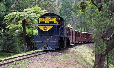
 Puffing Billy Railway
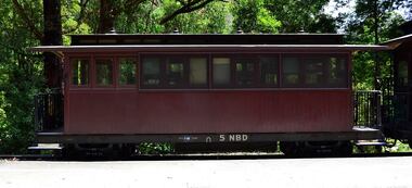
5 NBD, June 1901
... Railways Service History NBB 5. ( it's original number ) Built.... 5 NBD Victorian Railways Service History NBB 5. ( it's ...NBD This is a Puffing Billy Railway reclassification of the first series of NB carriages. COMBINED NB PASSENGER CAR AND GUARD'S VAN. A saloon or end platform NB which has had a guard's compartment temporarily added in one end. Due to the temporary nature of this conversion, this vehicle also retains its original number in the NB numbering sequence but is classed NBD to differentiate it from the standard NBC and the NAC. The use of the letter 'D' in the classification is recognising the code for guard's vans prior to 1910. NB Class - Number Built (1st Series) 6 - Number Built (2nd Series) 17 - Number Built (3rd Series) 4 NB (1st series) NB 5 was equipped with a vertical hand brake at one end to enable it to be used as the last vehicle of a train. Body Length 20 feet 6 inches ( 6248 mm) Vehicle Length 25 feet 2 inches ( 7671 mm) Coupled Length 27 feet 4 inches (8330 mm) Width 6 feet 3 inches (1905 mm) Height 9 feet 5 inches (2870 mm) Weight 8 tons Capacity 16 passengers Built 1898 - 1904 Number Built 6 In use NBD 1, 2, 5 NB - Puffing Billy Railway classed these as NBD to indicate their use as a trailing vehicle with guard's accommodation. 5 NBD Victorian Railways Service History NBB 5. ( it's original number ) Built new - - / 6/1901 Newport Workshops 4/ 2/1902 - In Service "Commenced running" circa 1910 - renumbered To NB 5 *NB 5. - / 6/1926 - Modified AC Malco 5/ 2/1951 - Scrapped - Body and underframe purchased by Puffing Billy Preservation Society from Pakenham. Restored by the Puffing Billy Preservation Society 1975. In July 2006 work commenced on 5 NB to make it a temporary kitchen car for the luncheon/dinner train. It has had the seating removed from the saloon and kitchen equipment installed. Plans are for a kitchen car to be constructed and 5 NB restored to carry passengers.Historic - Victorian Railways Narrow Gauge - Passenger Rolling Stock: Passenger and Guard's Van carriage 5 NBD - converted into Catering Car and Guards vanMade of Timber and steel 5NBDvictorian railways, narrow gauge rolling stock, 5nbd - catering car and van, puffing billy -
 Puffing Billy Railway
DH59 - Diesel Hydraulic locomotive (formerly DH 31), 1970
... for Queensland Railways between 1966 and 1974. In 1966 Queensland... Queensland Railways Service History : Locomotive : DH59 Serial ...DH31 - DH59 Diesel Hydraulic locomotive Built to 3'6" gauge in 1970 this Diesel Hydraulic locomotive entered service for the Queensland Railways where it remained until withdrawn in 1994. Purchased by the E.T.R.B. in 1995, it was converted to 2'6" gauge in Queensland and transported to Belgrave in 1996 for overhaul. It re-entered service later in 1996, although instead of receiving a V.R. type classification & number and V.R. style livery, it retained its Q.R. number of DH59 and its Q.R. livery minus the Q.R. logo, but has since been repainted the traditional Blue & Gold of V.R. diesel locomotives and reclassified DH31. It has since been returned to DH 59. The DH class was a class of diesel-hydraulic locomotives built by Walkers Limited, Maryborough for Queensland Railways between 1966 and 1974. In 1966 Queensland Railways tested a Walkers Limited built diesel-hydraulic shunting locomotive. This was later purchased and by 1974 the 73 DH class locomotives had taken over shunting duties in most Queensland yards. They were also used on short distance freight services. With the closure of many freight yards and the move to longer trains withdrawals started in the 1980s. Many were sold for further use on Queensland sugar cane railways. Locomotive's Queensland Railways Service History : Locomotive : DH59 Serial No: 646 In Service : 19/05/1970 With drawn from Service : 20/05/1991 LOCOMOTIVE DETAILS DH class No. originally constructed : 74 No. in service : 2 No. stored : Wheel arrangement : Bo-BoDH Roadworthy weight : 40T Maximum axle load : 10T Tractive effort (85%) Length overall: 33' Height overall : 12' 6 1⁄2" Driving wheel diameter : 36" Date of manufacture :1970 Manufacturer :Walkers Place of manufacture : Maryborough, Queensland Locomotive type : Diesel Hydraulic DH Class Type Diesel-Hydraulic Introduced 1966 Number in class 73 Manufacturer Walkers Gauge Narrow (QR, MIM) 900mm (SECV) Axles B-B Length 11.1 m Mass 37 t Engine Caterpillar D355E Transmission Voith L42U2 Power 347 kW / 465 HP Tractive effort 114 / 82 kN Speed 50 / 10 km/hHistoric - Queensland Railways - Diesel Hydraulic locomotive DH59DH59 Diesel Hydraulic locomotive made of steel and metalDH59 Diesel Hydraulic locomotivepuffing billy, diesel-hydraulic locomotive, dh59, dh31, walkers diesel hydraulic, queensland railways -
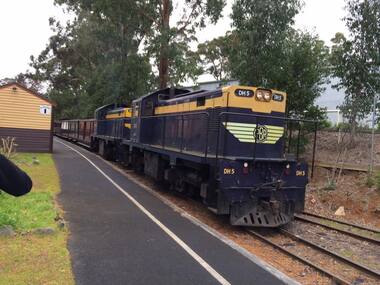 Puffing Billy Railway
DH 5 - Diesel Hydraulic locomotive, 1968
... Queensland Railways Service History : Locomotive : DH5 Serial No: 587... railways. Locomotive's Queensland Railways Service History ...DH5 Diesel Hydraulic locomotive The DH class was a class of diesel-hydraulic locomotives built by Walkers Limited, Maryborough for Queensland Railways between 1966 and 1974. In 1966 Queensland Railways tested a Walkers Limited built diesel-hydraulic shunting locomotive. This was later purchased and by 1974 the 73 DH class locomotives had taken over shunting duties in most Queensland yards. They were also used on short distance freight services. With the closure of many freight yards and the move to longer trains withdrawals started in the 1980s. Many were sold for further use on Queensland sugar cane railways. Locomotive's Queensland Railways Service History : Locomotive : DH5 Serial No: 587 In Service : 27/08/1968 With drawn from Service : 7/07/1992 LOCOMOTIVE DETAILS DH class No. originally constructed : 74 No. in service : 2 No. stored : Wheel arrangement : Bo-BoDH Roadworthy weight : 40T Maximum axle load : 10T Tractive effort (85%) Length overall: 33' Height overall : 12' 6 1⁄2" Driving wheel diameter : 36" Date of manufacture :1970 Manufacturer :Walkers Place of manufacture : Maryborough, Queensland Locomotive type : Diesel Hydraulic DESCRIPTION - B-B DH FORMER CLASS AND NUMBER - 8/1968 Built By - Walkers, Maryborough, Queensland Service History Date built - 1968 Original owner - Queensland Government Railways Original gauge - 1067mm Withdrawn - Next owner - State Electricity Commission of Victoria DH5 8/1968 Sold to SECV as CC2, In service 8-1993 Sold to Mackay Sugar CC02 (Ex DH5). CC02 was purchased by Cooks Construction in 1992 and used on the 900mm Yallourn railway in Victoria. Mackay Sugar purchased in 2001. Title Value Status Preserved - Operational Gauge Narrow 2ft 6in (762mm) Owners Puffing Billy Railway Operators Puffing Billy Railway Manufacturer Walkers Ltd - Maryborough, Queensland Builders number 587 Associated locos Renumbered from CC02 Liveries carried VR Blue & Gold Puffing Billy Service History or Notes Date acquired - 2008 Acquired from - Mackay Sugar Mill ? State when acquired - Operational ? Work done - Regauged, overhauled Restored to service - Current State - Operational Historic - Queensland Railways - Diesel Hydraulic locomotive DH5DH 5 Diesel Hydraulic locomotive made of steel and metalDH 5puffing billy railway, dh5, locomotive, cc02, diesel,, queensland railways, diesel hydraulic locomotive dh5, walkers diesel hydraulic -
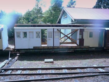 Puffing Billy Railway
8 NB - Compartment Passenger Carriage, 1906
... 8 NB - 6 compartments (40) Victorian Railways Service...) Victorian Railways Service History 8 NB - passenger carriage (PBPS ...8 NB - 6 compartments (40) Victorian Railways Service History 8 NB - passenger carriage (PBPS Body only - currently no underframe) 21 Dec 1906 Built New at Newport Workshops - numbered classed as NBB 8. Type: 2nd Class swing door carriage - 5 or 6 compartments 2'6" Bogie [8W]: Eight Wheels (2 x Four Wheel bogies) [CDG]: Continuous Draw Gear [WHB]: Westinghouse Brake circa 1910 - reclassed to NB 8 May 1926 - Modified with Automatic Couplers Malco Oct 1928 - Modified with Automatic Couplers Malco Bottom Operated 16 Dec 1937 - Consigned as to be scrapped 19 Feb 1938 - Condemned 4 Mar 1938 - Scrapped & Broken Up - Condemned Rolling stock Book Body to be offered for sale & underframe & bogies retained for use in construction of any additional NG trucks undertaken in near future. Sold by V.R and privately bought and used in the construction of a house at 80 Dare Street, Ocean Grove Puffing Billy Preservation Society Service History or Notes Sept 2010 - Ocean Grove house demolition results in PBPS being contacted that there were two carriages (6 NB & 8 NB) in the house. PBPS arrange to buy the two carriages bodies from the Demolition company Nov 2010 - Two carriages have been rescued from 80 Dare Street, Ocean Grove where they had been built into a house. Many people were involved in the move: thanks go to Raymond and Thelma Cotter for providing tarps to protect the cars from the elements. Dec 2010 - Two carriages rescued from Ocean Grove are now at Emerald, one being a platform NB car (6NB) and the other 8 NB a 2nd Class swing door carriage. Minor refurbishment has taken place along with covering with Tarpaulins. 29 Jan 2020 - 8 NB - passenger carriage - Body only is moved by the PBPS Heritage Rolling Stock Committee from Emerald Station sidings and placed into storage in a warehouse at Officer to enable it to be investigated into its possible restoration. 29 Feb 2020 - investigation on the carriage by the PBPS Heritage Rolling Stock Committee found the number of the carriage 8 NB stamped on the inside of the side of the windows frames. Current - At OfficerNB Class - Number Built (1st Series) 6 - Number Built (2nd Series) 17 - Number Built (3rd Series) 4 Historic - Victorian Railways Narrow Gauge - Passenger Rolling Stock: Passsenger carriage. 14 NB and this carriage (both of the 2nd Series) are the last known existing vehicles of this type out of the 17 built - maybe!.Passenger Rolling Stock: ? NB - Passenger carriage - Made of Timber NB - 2nd Class swing door carriage - 5 compartments number unknown ? NB puffing billy, nb passenger carriage, victorian railways, narrow gauge passenger rolling stock, 2'6" gauge -
 Federation University Historical Collection
Booklet, Beautiful Ballarat, 02/1918
... : Ballarat history, Eureka, Railway facilities, Railway fares... railway lake wendouree w.f. coltman bert skinner frank besemere ...Purple soft covered booklet of 102 pages. Includes numerous advertisements and black and white illustrations. Topics include: Ballarat history, Eureka, Railway facilities, Railway fares to Ballarat, Lake Wendouree, Ballarat Botanical Gardens, Ballarat Zoological gardens, Ballarat Statues, Ballarat Mines and Mining, Illustrations include: Ballarat Brewing Company, passenger steamer on Lake Wendouree, Provincial hotel, Eureka Lead, Lydiard Street, Sturt Street, Ballarat Town Hall, Ballarat East Town Hall, Sunnyside Woollen Mills, Fairyland, Loch Leven Trout caught in Lake Wendouree, Ballarat Botanical Gardens, Boer War Monument, New Imperial Gold Mine, South Street Competitions, Art Gallery of Ballarat, Ballarat School of Mines, Ballarat Grammar School, Ballarat College, St Patrick's College, Ballarat Agricultural High School, Mt Clear flowering grass trees (Xanthorea Australis), Eureka Stockade Monument, Ballarat YMCA, Lake Burrumbeet, Bo-peep Creek, Moorabool Falls, Lal Lal Falls Advertisements include: Ronaldson bros. and Tippett, Charles Morris undertaker, James Smith, Huttons the jewellers, Allchin Bros, Wallace Butter Factory, F.W. Barnes and Son, Berry, Anderson and Co., Rowlandsballarat, new imperial gmc, sunnyside woollen mill, brewery, royal standard brewery, st patrick's college ballarat, ballarat grammar school, ballarat school of mines, ballarat east town hall, ballarat east botanical gardens, abc grill & tea room, a.m. palmer chemist, thomas' supply stores, ballarat brewing company, stevens the furriers, summerscales, paddlesteamer on lake wendouree, hutton's the jewellers, allchin brothers, fiat motor garage, eureka stockade, w. cornell, cornell's liver pills, f.w. barnes and son, w. rotchie's, railway, lake wendouree, w.f. coltman, bert skinner, frank besemere, fred a. reed, ballarat zoological gardens, jelbarts, brinds, rowlands soda water, american club hotel, armstrong street south, ballarat woollen mill, southern cross hotel -
 Melton City Libraries
Photograph, Melton Railway Bridge, c.1884
... , documenting an important episode in local history. The railway... an important episode in local history. The railway enabled ..."The Melton Viaduct, opened in 1886, is of State heritage significance as a very large and visually distinctive wrought iron, lattice girder trestle bridge over the Werribee River (now Melton Reservoir). It comprises 18.3 and 9.1 metre spans, in a generally alternate arrangement, of total length 375 metres, and standing 38 metres over the Werribee River. Wrought iron small section iron was used to build tension trussed trestle legs, which supported four lines of rivetted wrought-iron deck-type double lattice trusses. It has bluestone abutments and pier bases of coursed rock-faced bluestone with drafted margins. The larger half-piers, now usually submerged in the Melton Reservoir have sharp tapered cutwaters and curved coping at the tops. While designed to carry two rail tracks it has only ever been used as a single track line. Despite several alterations to its deck structure, it remains an outstanding example of a lighter structural design employing open metal trestle supports and metal truss girders. The direct Melbourne to Ballarat railway link of which the Melton viaduct was the major engineering work contributed significantly to the history and development of Victoria. This new link reflected Ballarat’s diversifying economy as well as the commercial and political influence of the metropolis. Construction of the bridge, and the associated large workers camp, were extensively photographed, documenting an important episode in local history. The railway enabled the development of new industries in the Melton area, notably the timber industry and a chaff industry of national importance, greatly facilitated the later transition of the Shire from a pastoral to a farming economy, and struck a major blow to Melton township’s era as a wayside town servicing Ballarat road (especially coach) traffic". Melton Railway Bridge being built across the Werribee Rivertransport -
 The Beechworth Burke Museum
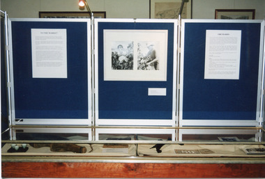
Photograph, 1999
This photograph features three display board sections showing information and photographs from 'The Harvest' exhibition inside the Burke Museum at Beechworth in 1999. The boards are titled 'To the Market' and 'Orchards'; the accompanying text cannot be read. The two accompanying photographs depict a man and woman picking fruit.This photograph is of social significance to Burke Museum and the Beechworth community, documenting an exhibition, The Harvest, held in 1999 to communicate the importance of agricultural development, specifically of orchards, in the area. The expansion of vineyards and horticulture in the Beechworth district followed gold rush prosperity in the mid-1850s, with nearly ninety acres of gardens and small farms under vineyards by 1865. There were 400 Chinese market gardeners and hawkers in the area in 1868. The growth of agriculture in the Ovens district in the mid -1860s led to advocacy by local farmers for the extension of railway infrastructure from Melbourne to improve access to distant markets.Colour rectangular photograph printed on matte AGFA photographic paper.Obverse: TO THE MARKET / ORCHARDS/ Reverse: 2856beechworth, burke museum, promoting settlement, living in country towns, making regional centres, preserving traditions and commemorating, farming and agriculture, orchards, exhibitions, burke museum exhibitions, fruitpicking, building local economies, transforming land, victorian agricultural history, marketing and promoting agricultural products, growing fruit and vegetables, the harvest exhibition, harvests, vineyards, victorian gold rush towns -
 The Beechworth Burke Museum
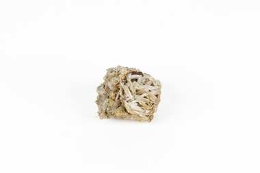
Geological specimen - Chalcopyrite
This specimen originated from Mount Lyell on the west coast of Tasmania, where a large group of open cut and underground copper-silver-gold mines began operating in 1883. Between 1893-1994, the Mt Lyell Mining and Railway Company were responsible for operations. The Mt Lyell copper-gold mines produce some excellent crystallised specimens of chalcopyrite and other minerals. The deposits are generally considered to be of Cambrian volcanic origin, but there are indications of Devonian granitic influence on the ores, plus local remobilisation during Devonian deformation. Over 120 million tonnes of ore was produced from several workings, including the main Prince Lyell mine and the North Lyell mine, which was also of great importance. The Mount Lyell mines have a long history of human and environmental disasters, including the 1912 North Lyell fire that killed 42 miners, and two separate incidents in 2013 in which three people lost their lives. The environmental impacts from this complex of mines are extensive, with waste tailings and heavy metal contamination flowing directly into the King and Queen River catchments. In 1954, the eminent Australian historian, Geoffrey Blainey, published 'The Peaks of Lyell' which delves into the history of the 1912 North Mount Lyell Disaster.Chalcopyrite does not contain the most copper in its structure relative to other minerals, but it is the most important copper ore since it can be found in many localities and occurs in a variety of ore types. The brassy-yellow colours in Chalcopyrite mean it is often confused with pyrites and gold, leading to use of the term, "fool's gold." Chalcopyrite has been the primary ore of copper since smelting began five thousand years ago. This specimen is part of a larger collection of geological and mineral specimens collected from around Australia (and some parts of the world) and donated to the Burke Museum between 1868-1880. A large percentage of these specimens were collected in Victoria as part of the Geological Survey of Victoria that begun in 1852 (in response to the Gold Rush) to study and map the geology of Victoria. Collecting geological specimens was an important part of mapping and understanding the scientific makeup of the earth. Many of these specimens were sent to research and collecting organisations across Australia, including the Burke Museum, to educate and encourage further study.This hand sized solid mineral specimen has shades of brass-yellow with spots of iridescent green-black tarnish. Chalcopyrite is a copper iron sulphide mineral and a major ore of copper common in sulphide veins and disseminated in igneous rocks. Chalcopyrite has a hardness of 3.5-4 on the Mohs Scale. It is a member of the tetragonal crystal system and has metallic lustre and opaque transparency.burke museum, beechworth, indigo shire, beechworth museum, geology, geological specimen, chalcopyrite, copper pyrites, copper mining, tasmanian geology, mount lyell, mount lyell mines, fools gold, mohs scale, crystals, minerals, historical geological collection, victorian geological survey, a.r.c selwyn, gold rush, van diemans land -
The Beechworth Burke Museum
Audio - Oral History, Jennifer Williams, Mr Bill Gerrard, 10 August 2000
Bill Gerrard was born in Albury in 1934 and moved to Beechworth in 1960 when his wife was employed as a nurse at Mayday Hills Hospital, later becoming nurse-in-charge. Gerrard first worked for the local railway and then as a taxi driver in Beechworth, and was involved in volunteer fund-raising activities such as raffles for charitable causes. This oral history recording was part of a project conducted by Jennifer Williams in the year 2000 to capture the everyday life and struggles in Beechworth during the twentieth century. This project involved recording seventy oral histories on cassette tapes of local Beechworth residents which were then published in a book titled: Listen to what they say: voices of twentieth century Beechworth. These cassette tapes were digitised in July 2021 with funds made available by the Friends of the Burke.Mr Bill Gerrard's account of his life in Beechworth and the local area during the mid-to-late 20th century is historically and socially significant to the cultural heritage of the region. He recounts aspects of community life and working conditions in Beechworth, particularly during the 1960s and 1970s, as well as conditions for staff and patients at Mayday Hills Hospital where his wife worked during that period. His story also provides insights into economic hardhsip and the role of voluntary fundraising in the Beechworth community. This oral history recording was part of a project conducted by Jennifer Williams in the year 2000 to capture the everyday life and struggles in Beechworth during the twentieth century. This project involved recording seventy oral histories on cassette tapes of local Beechworth residents which were then published in a book titled: Listen to what they say: voices of twentieth century Beechworth. These cassette tapes were digitised in July 2021 with funds made available by the Friends of the Burke.This is a digital copy of a recording that was originally captured on a cassette tape. The cassette tape is black with a horizontal white strip and is currently stored in a clear flat plastic rectangular container. It holds up 40 minutes of recordings on each side.Mr Bill Gerrard /listen to what they say, beechworth, oral history, burke museum, bill gerrard, mayday hills hospital, taxi driver, beechworth railway, religion, beechworth 1960s, beechworth 1970s, social welfare, community cohesion, twentieth-century working conditions, twentieth-century regional victoria, hibernian hotel, fund-raising -
 The Beechworth Burke Museum
Geological specimen - Cerussite, Unknown c.1890s
Named in 1845 by Wilhelm Karl von Haidinger cerussite takes its name from the Latin cerussa, meaning 'white lead'. When viewed under certain lighting conditions cerussite gives of fire and rainbow-like colours (due to its high dispersion) and it is quite sought after by geological collectors for this very reason. Cerussite is usually found in the oxidised zone of lead ore deposits. It is a very common weathering product of galena and other lead ore minerals. It is a secondary mineral, meaning it forms as a result of the alteration of pre-existing minerals in the Earth’s crust. The presence of lead in cerussite makes it potentially toxic. Historically, it has been an important source of lead, which has numerous industrial applications, including in batteries, construction materials, and radiation shielding. Cerussite has a crystal structure that belongs to the orthorhombic crystal system. Its crystal structure is characterized by a three-dimensional arrangement of atoms in a repeating pattern. The crystal lattice of cerussite consists of interconnected lead (Pb) and carbonate (CO3) ions. This crystal structure is visible in the specimen. This specimen was found in Dundas (formerly Mount Dundas), a historical mining locality, mineral field and railway located on the western foothills of the West Coast Range in Western Tasmania. During the 1890s Dundas swelled in numbers however it is now lost in a temperate rainforest and its population is now 2. The present Dundas Extended mine, about 1.5 km east of Dundas is presently worked for specimen material.Faceted cerussite gems are considered rare and valuable, given the softness of the mineral. This item is not a faceted gem however its historical and scientific research potential give it significance; mined in an Australian township, this cerussite could shed light on the now lost history of Dundas and the mining that occurred there. Additionally, the uses of this mineral in historical industrial processes give it scientific significance. Such knowledge can add to understandings of the geographical and geological nature of Western Tasmania and allow for further study of Australian geological specimens. A small lead carbonite mineral with shades of cream, white and brown throughout, flaky shards of white at base. CERUSSITE / (lead carbonite) / Locality: Dundas, W. Tasmaniadundas, tasmania, cerussite, lead, orthorhombic, geology, minerals, mining -
 The Beechworth Burke Museum
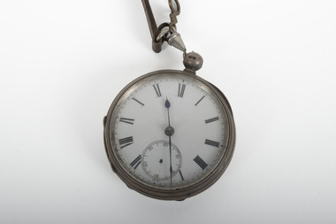
Functional object - Pocket Watch, C.1853
Although the exact creation of this pocket watch is unknown, the pocket watch was first invented in 1510, in Nuremberg, Germany. The inception of this invention can be attributed to Peter Henlein, a master locksmith who continued producing timepieces until the 16th century when their manufacturing expanded to other parts of Europe. During the 15th century, pocket watches served as a means of distinguishing between the lower classes and the affluent members of society since only the wealthy could afford them. In this era, an early version of the pocket watch was typically worn around the neck, as opposed to being attached to a pocket watch chain like the Albert T Bar chain. Furthermore, the increasing use of the railways during the latter part of the 1800s significantly accelerated the popularity of pocket watches.This pocket watch is significant as they relate to the social history within the Burke Museum's collection playing a vital role in narrating the history of Beechworth, demonstrating the past of the town through insights into its social, cultural, and economic dimensions.A silver pocketwatch with a leather strap attached at the clasp.A01153clock, pocketwatch, timepiece, burke museum -
 Orbost & District Historical Society
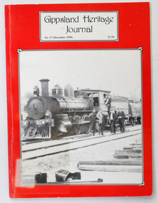
journals, E-Gee Printers, Gippsland Heritage Journal, December 1994
... journal-Gippsland-Heritage-Journal history-railway... to Orbost Railway. journal-Gippsland-Heritage-Journal history ...This magazine was edited by Meredith Fletcher.This journal is a useful reference for the history of the Bairnsdale to Orbost Railway. Two copies of a 64 pp magazine, titled Gippsland Heritage Journal. It has a red cover with a b/w photograph of a special train taking workers to Melbourne for a Christmas break c 1915. The journal is No 17, December 1994 and cost $7.50. It contains an article , "Tent Life on the Orbost Line" with photographs and history of the Bairnsdale - Orbost railway line.2426.1 has a call no. on front cover 994.56 and a bar code on the back cover GIP journal-gippsland-heritage-journal history-railway -
 Orbost & District Historical Society
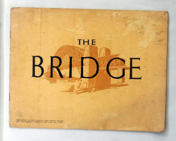
book, The Bridge, 1930's
This book was written by Dr J. J. C. Bradfield, (John Job Crew), 1867-1943. Dr JJC Bradfield was a visionary Australian engineer who worked with enormous energy and vision to build the infrastructure which he foresaw that Sydney would need as it grew. As early as 1903 Bradfield was making the case for the Sydney Harbour Bridge, in his presidential address as President of the Sydney University Engineering Society. Bradfield’s proposal — at that stage for a cantilever bridge between Dawes Point and Milsons Point — won the committee’s support and they recommended it be accepted. However, the First World War put a stop to these plans. While a bill to authorise the project passed the lower house of the NSW parliament in 1916, it failed to pass the upper house, on the grounds that funds should not be diverted from the war effort. With the war over, in 1922 the Sydney Harbour Bridge Act was passed by the NSW Parliament. The Sydney Harbour Bridge was officially opened in 1932 after Museum and St James railway stations were built. This book was written from the story broadcast by Dr. J.J.C. Bradfield. This item is a useful reference tool.A staple soft cover 16 pp booklet with a buff coloured cover. It has a sketch of the Sydney Harbour Bridge behind the title "The Bridge" in dark brown print. It contains information and photographs of the history and construction of Sydney Harbour Bridge.sydney-harbour-bridge bradfield-dr-j-j-c -
 Orbost & District Historical Society
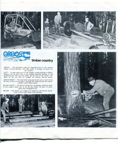
pamphlet, VR Printing Works, Railways, 1975
This pamphlet was produced by Victorian Railways. In 1976 the name Victorian Railways was replaced by Vicrail.Railways have played a key role in Victorian transport especially in linking regional towns to the cities. The railways have provided jobs for many Orbost people. This item is associated with the history of the Orbost-Bairnsdale railway line and therefore reflects the role that the rail line played in the social and economic history of Orbost.A pamphlet produced for Victorian Railways. On the front is a coloured photograph of a train. It contains photographs and an article about Orbost as "Timber Country" and a detailed article titled, " Cutting Sleepers is a Family Business" which tells about the Donchi family.pamphlet-victorian-railways sleeper-cutting donchi