Showing 9430 items
matching the boulevard
-
 Wodonga & District Historical Society Inc
Photograph - A. Arnold General Merchants, Wodonga
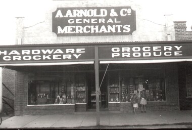
In 1924, Arthur Arnold and his father Wilhelm Arnold had established a general store in High Street, near the water tower, but in 1931–32 they moved to new premises in High Street on the corner of what is now known as Elgin Boulevard. In 1933-34 they widened the frontage of the shop and added new premises at the rear for the sale of produce. The Arnolds continued to trade until they finally closed their store in 1950. Wilhelm Arnold was a brother of J G Arnold, whose business ultimately became the present-day Arnold’s Fruit Market, Wodonga.This is an image of an early Wodonga businessman who was also active in the communty.A black and white image of 2 children looking through the window of Arnold's store. A newspaper advertisement for the company is also included.Above Shop: A.ARNOLD & Co. / HARDWARE - GROCERY/ CROCKERY - PRODUCEwodonga businesses, a arnold general merchant -
 Eltham District Historical Society Inc
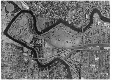
Photograph - Aerial Photograph, Landata, Montmorency, Vic, Apr. 1972
Centred on present day Olympic Avenue at Grand Boulevard, Montmorency bounded by Meruka Drive to north, Main Road to south, Main Road to east and Alban Street to west. Historic Aerial Imagery Source: Landata.vic.gov.au Aerial Photo Details: Project No :985 Project : MELBOURNE 1972 Run : 28 Frame : 206 Date : 04/1972 Film Type : B/W Camera : RC10 Flying Height : 5700 Scale : 9600 Film Number : 2635 GDA2020 : 37°43'21"S, 145°07'46"E MGA2020 : 335154, 5823329 (55) Melways : 21 E7 (ed. 42)aerial photo, neil webster collection, 1972-04, eltham, alban street, grand boulevard, lower plenty, main road, melway 21e7, meruka drive, montmorency, olympic avenue -
 Vision Australia
Newsletter - Text, Out and About: RVIB Auxiliaries newsletters 2005 (March, June, Spring), 2005
RVIB Auxiliaries raised monies for the organisation at a grassroots level, via a variety of meetings, fundraisers and events. To keep them in touch with head office and to let branches what other branches were doing across the state, regular newsletters were sent out. The final meeting of the Central Council of Auxiliaries at the home of Trudi Westh, and the winding down of the Leongatha, Essendon, Korumburra, Greensborough, Wodonga and Koo Wee Rup branches, the launch of the RVIB history book 'Lighthouse on the Boulevard' and an interview with RVIB client Karen Nelson about her upcoming book on her life story.20 pages of text and imagesroyal victorian institute for the blind, auxiliaries -
 Eltham District Historical Society Inc
Photograph, Construction of the new concrete bridge over the Diamond Creek on Main Road, Eltham, c.May 1926
Construction of the new concrete bridge over the Diamond Creek on Main Road, Eltham, c.May 1926. Viewed from northern approach looking east, the access drive running off Antoinette Boulevard parallel to Main Road is visible as well as the power lines that used to run in front of Eltham Park (Eltham Lower Park). Also visible is a tree situated beside the roadway. It is believed this is the same tree that remains today as a dead tree trunk immediately adjacent to the road verge armco near the corner of Antoinette Boulevard. The original long suspension bridge over the Diamond Creek on Main Road at Eltham collapsed during flooding of the Diamond Creek on October 13 and 14, 1923. The original bridge was built around 1840 for the coach road when Cobb & Co.'s coach was the only conveyance between Eltham and Melbourne. Widespread damage was done in Melbourne and surrounding areas by floods resulting from the overflow of the Yarra at many points along its banks. A temporary bridge rigged up was severely damaged by the flooding of the creek and was closed to vehicular traffic in April 1924. A new concrete bridge was constructed to replace it and by May 1926 all the concrete piles and abutments had been completed. The bridge was finally completed and opened for traffic in September 1926, almost three years after it initially collapsed.This photo forms part of a collection of photographs gathered by the Shire of Eltham for their centenary project book,"Pioneers and Painters: 100 years of the Shire of Eltham" by Alan Marshall (1971). The collection of over 500 images is held in partnership between Eltham District Historical Society and Yarra Plenty Regional Library (Eltham Library) and is now formally known as the 'The Shire of Eltham Pioneers Photograph Collection.' It is significant in being the first community sourced collection representing the places and people of the Shire's first one hundred years.Photo print 9 x 12.5 cmshire of eltham pioneers photograph collection, eltham, bridge, diamond creek (creek), eltham south, main road bridge, wingrove park, antoinette boulevard, significant tree, cement mixer, bridge construction -
 Melbourne Tram Museum
Negative - Set of 2, Ellis Collection, c1940?
Set of two Negatives (120) of a wide body car crossing the Wallen St Road Bridge Hawthorn possibly after the construction of The Boulevard. Taken from either side of the river. Hi Res image filed in the dbtext/hawthtramcoll/Large Images/htd3595aLarge.jpg and htd3595bLarge A low resolution A4 laminated was received with the negatives. Image i2 - taken from Glan Avon Rd in Hawthorn of Wallen Rd bridge – the tram is one of three SW2 class trams (not the first one due to the door sizes, but one of 426, 432 or 478, most probably 478 as that was a Camberwell car)trams, tramways, wallen rd, bridges, sw2 class -
 Eltham District Historical Society Inc
Photograph, 1934 Floods at Eltham
Published in the Diamond Creek Basin Study, 1980 and identified at Diamond Creek, locality not identified, 1934. The location is actually looking south across the Diamond Creek towards Falkiner Street, beside the Main Road bridge at Eltham South from what is now part of Wingrove Park opposite Antoinette Boulevard. The bridge railing is just visible to the left of image. The large leaning Manna Gum beside the bridge still stands in 2021 alongside the Diamond Creek trail. In 1934 extensive flooding of the Yarra River and Diamond Creek set new records for flood plain level (Eltham Chronology, EDHS)Black and white photographCopied by Hugh Fisher, Photographer, 6 York Street Eltham A1678B Floods- Eltham - 1934floods, yarra river, eltham, flooding, diamond creek, flood -
 Eltham District Historical Society Inc
Photograph - Aerial Photograph, Landata, Montmorency, Feb. 1956
Centred on present day Grand Boulevard and Olympic Way, Montmorency bounded by Diamond Street to north, Old Eltham Road and Eltham Lower Park to south, Bible Street to east and Para Road to west. Historic Aerial Imagery Source: Landata.vic.gov.au Aerial Photo Details: Project No :250 Project : MELBOURNE OUTER SUBURBS PROJECT Run : 17 Frame : 115 Date : 02/1956 Film Type : B/W Camera : EAG9 Flying Height : 10000 Scale : 12000 Film Number : 1176 GDA2020 : 37°43'24"S, 145°07'55"E MGA2020 : 335375, 5823236 (55) Melways : 21 F7 (ed. 42)aerial photo, 1956-02, neil webster collection, eltham, main road, montmorency, bible street, diamond street, eltham lower park, grand boulevard, melway 21f7, old eltham road, olympic way, para road -
 Eltham District Historical Society Inc
Photograph - Aerial Photograph, Landata, Eltham, Vic, Apr. 1972
Centred on present day Diamond Creek Trail at the Eltham Leisure Centre bounded by Central Park to north, Main Road at Falkiner Street to south, MacMahon Ball Paddock to east and Grand Boulevard at Buena Vista Drive to west. Historic Aerial Imagery Source: Landata.vic.gov.au Aerial Photo Details: Project No :985 Project : MELBOURNE 1972 Run : 28 Frame : 207 Date : 04/1972 Film Type : B/W Camera : RC10 Flying Height : 5700 Scale : 9600 Film Number : 2635 GDA2020 : 37°43'25"S, 145°08'20"E MGA2020 : 335985, 5823223 (55) Melways : 21 G7 (ed. 42)aerial photo, neil webster collection, 1972-04, eltham, buena vista drive, central park, diamond creek trail, eltham leisure centre, falkiner street, grand boulevard, macmahon ball paddock, main road, melway 21g7 -
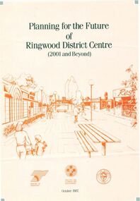 Ringwood and District Historical Society
Pamphlet, Planning for the Future of Ringwood District Centre 2001 and Beyond - October 1987
A4 size 6-page multi-fold consultants' report outlining Ringwood's central structure plan for the new millennium. Topics: Traffic Circulation and Parking, Regional Retailing Focus, Entertainment Precinct, Office Precinct, Railway Precinct, Residential Conservation Zones, Retail Specialty Core, Commercial Boulevard, Possible Station Street Upgrading. Planning consultants - Wolinski Planners Pty. Ltd., were commissioned by Ministry for Planning and Environment, City of Ringwood and the Ministry of Transport in 1986 to prepare and exhibit the plan for public comment. After consideration of responses, the Working Group will make recommendations to the Council and Ministers subject to hearings of any formal submissions. -
 Lara RSL Sub Branch
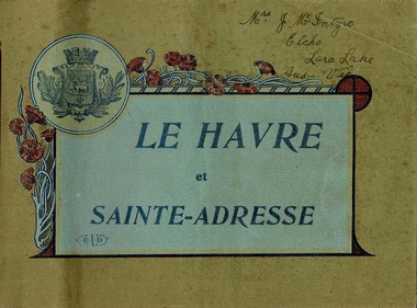
Booklet, Le Havre et Sainte-Adresse, circa 1917
Le Havre is an urban French commune and city in the Seine-Maritime department in the Normandy region of northwestern France. It is situated on the right bank of the estuary of the river Seine on the Channel southwest of the Pays de Caux. The sixteen photos are from circa 1917.Important Booklet as it shows rare photos of an area in France during WW1.Booklet with light cardboard cover bounded by red stringFront page is crest with poppies and titled Le Havre et Sainte-Adresse with initials E.L.D (printers initials). Written in pen on the top right corner are the words Mrs J.McIntyre Elcho Lara Lake Aus - Vic. On the back page is a stamp, Catalogues Industriels E. Le Deley 127, Boulevard Sebastopol, Paris Inside are photos of of the area around Le Havre, Franceelcho, lara lake, le havre, france, ww1, world war one, mcintrye, j. mcintrye, vue general, l'hotel de ville, sainte-adresse, vue d'ensemble du boulevard maritime, sainte-adresse - la heve, sainte-adresse - ensemble du nice-havrais, le casino et la plage, bassin du commerce, sainte-adresse - boulevard felix-faure, panorama pris de l'hotel de ville et rue de paris, le transatlantique "france" 220m de long entrant au port, "la provence" entrant au port par gros temps, sainte-adresse - ensemble du nice-havrais et des nouvelles villas, place gambetta, le nouveau casino marie-christine 1910, le pont du commerce et la bourse -
 Kew Historical Society Inc
Plan - Charteris Estate, Ivanhoe [East], 1927
Subdivision plans and real estate flyers/brochures reveal a number of aspects of urban development and history. The Kew Historical Society's collection of these plans, as well as advertisements extracted from magazines, cover key aspects of community development and architectural history of Kew and Kew Eat as well as surrounding suburbs. While most of the plans in the collection were gifted to the Society by the former City of Kew, a number of other plans and advertisements have been donated by individuals, of which this is an example.Original 4-page bifold handout advertising 43 residential lots for sale in the Charteris Estate subdivision in Ivanhoe [now classified as Ivanhoe East]. This brochure was created to sell the third section of the estate which it labels as 'The Most Superb Section'. Streets within the subdivision include: Burke Road North, McArthur Road, Castella Street, and the Government Boulevard. In addition to the overall plan spread across pages 2 and 3, each page includes a number of interesting photographs including: a number of the new Burke Road Bridge, a sports ground, Hoyts Picture Theatre in Ivanhoe, a croquet ground, and Ivanhoe shopping centre [named Motor Cross Junction].charteris estate - east ivanhoe (vic), subdivision plans -- ivanhoe east (vic.), d.c. mcarthur, charterisville -
 Ringwood and District Historical Society
Photographs, Agfa, Heathmont shops and locations in Dec 1999 (25 Photos), 29-Dec-99
Photographs (25) B&W of Heathmont shops, buildings, parks, train tracks, scout hall, toilet block.Canterbury Road, Heathmont, looking south-west (3226_001.jpg); Southern part of Heathmont shopping centre, looking west (3226_002.jpg); Canterbury Road, Heathmont, looking north (3226_003.jpg); McLean's Real Estate, Heathmont (3226_004.jpg); Northern part of Heathmont shopping centre (3226_005.jpg); Heathmont shops (3226_006.jpg); Heathmont shops (3226_007.jpg); Heathmont dry cleaners (3226_008.jpg); Heathmont newsagency (3226_009.jpg); Heathmont Mother's General Store (3226_010.jpg); The Boulevard, Heathmont (3226_011.jpg); Heathmont train (3226_012.jpg); Heathmont public toilets (3226_013.jpg); Heathmont railway crossing, Allens Road (3226_014.jpg); Heathmont bicycle path, near Allens Road (3226_015.jpg); Cnr Allens Road and The Boulevard, Heathmont (3226_016.jpg); Heathmont bicycle path, near Allens Road (3226_017.jpg); Oval No. 1, HE Parker Reserve, Heathmont (3226_018.jpg); Cnr Allens Road and The Boulevard, Heathmont (3226_019.jpg); 2nd Ringwood Scout Group, HE Parker Reserve (3226_020.jpg); Railway line looking towards Heathmont Station (3226_021.jpg); HE Parker Reserve sign (3226_022.jpg); Heathmont supermarket (3226_023.jpg); Heathmont greengrocers (3226_024.jpg); Heathmont railway crossing, near Allens Road (3226_025.jpg) -
 Eltham District Historical Society Inc
Photograph, Fay Bridge, Eastern boundary of former Warrandyte Aboriginal Reserve, North Warrandyte, 7 November 2016
Two bronze commemorative plaques on rocks, unveiled by Wurundjeri Tribe Council Elders, mark two eastern boundaries of the former Warrandyte Aboriginal Reserve on the north and south sides of the Yarra. This project was initiated by Nillumbik Reconciliation Group in close association with Reconciliation Manningham and the Wurundjeri Tribe Council, as a means of commemorating the last great corroboree of the Kulin Nation which was held at Pound Bend in March 1852. This plaque is on the Nillumbuk side of the Yarra, accessed via The Boulevard, North Warrandyte. The plaque is set on a rock approximately 50 metres before the turning circle at the end of The Boulevard. Plaque : Warrandyte Aboriginal Reserve This commemorative rock marks an eastern boundary of the former Warrandyte Aboriginal Reserve established in 1852. Centred on Pound Bend, it covered 1,908 acres on both sides of the Yarra River (Birrarung). That same year saw the last great gathering of the Kulin nation here in Wurundjeri country which was celebrated over two weeks with traditional performance and games. For a few years longer the reserve intermittently served as a ration station.With gold having been discovered at Warrandyte, the Wurundjeri were moved on again but ultimately secured a permanent home at Coranderrk, Healesville. A second commemorative plaque and rock is located on the opposite bank of the Yarra and its confluence with Stony Creek. Melway ref : 23 C 9 Unveiled by Wurundjeri Elder, Uncle Bill Nicholson on 23rd March 2013 Funded by the Robert Bridgford Indigenous Trust (Nillumbik Community Fund) with assistance from Manningham City Council Small Grants Program Ref: Monument Autralia https://monumentaustralia.org.au/themes/culture/indigenous/display/99680-warrandyte-aboriginal-reserve-fay bridge collection, 2016-11-07, aboriginal reserve, north warrandyte, plaques, warrandyte aboriginal reserve -
 City of Moorabbin Historical Society (Operating the Box Cottage Museum)
Transport, Bicycle 'Bastide' 1909, c1909
1891 Paris - Bordeaux Cycle Race started in the Place du Pont Bastide in Bordeaux. So the name Bastide was already known to cycle enthusiasts even before the cycle manufacturer made its first iconic bicycle.The Bastide frame was built from top quality English Reynolds tubing with lugs and fittings provided by BSA. (Birmingham Small Arms Company ). Bastide, was based at Boulevard de Clichy, Paris and turned these fittings into a totally superb racer. Leon (Jack) Meredith,UK Olympic Cycling Champion, of the Constrictor Tyre Company, was responsible for importing the first Bastides and displaying them at the 1913 Olympia Cycle show where they were the sensation of the show. The Bastide, though almost as expensive as top range cycles, was fitted with a single brake and gear and no trimmings and was lighter, slimmer and faster Weight 15lb. ( 6.8Kg) Bastide stopped making frames in 1936. Bastide was the bike that changed the style for road bikes in England for ever more after the First World War 1914-18 and this bicycle was used by Mr L Forde in Moorabbin Shire c1910A Racing Bicycle c1909 'BASTIDE"Frame Bastide Frame Stem ; Perfect / BUILT BY / CANADA CYCLES / & MOTOR Gear wheel ; BSAparis-bordeaux cycling road race, bicycles, bastide bicycles paris, birmingham small arms company uk , meredith leon jack , olympic cycling, road races, cycling clubs, cheltenham, moorabbin, victoria, geelong, werribee, whitehead clarice, whitehead eric, world war 1914-1918, early settlers, moorabbin shire, bentleigh, -
 Melbourne Tram Museum
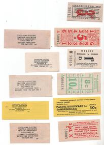
Ephemera - Ticket/s, Australian Electric Traction Association (AETA), Miscellaneous tickets and travel dockets, 1993
Set of six replica tickets (two of each except for item 1) for AETA 50th Anniversary Easter 1993 tours .1 - VR St Kilda Brighton 3d - Modern Trams tour - 10/4/1993 .2 - HTT - 5d, Bendigo tram tour 12/4/1993 .3 - MBCTT - 1d, Bellarine tour11/4 or 15/4 1993 - change of date on one sample. .4 - SEC - 10d / 8c ticket for the Ballarat tour 9/4/1983 .5 - VR Motor coach - 50c, Pacific Boulevard to Sandringham - used for the Bylands and Yamgardook tour 14/4/1993. .6 - MMTB - cable tram through fare - 1 1/2d - ASEA Brown Boveri Tour - 8/4/1993.trams, tramways, aeta, htt, vr, tickets, secv, tours, railways -
 Kew Historical Society Inc
Photograph - Yarra Street, Kew, Ron Setford, 1960
Ron Setford and his wife Grace Setford lived in Tanner Avenue, East Kew, from c.1946 to c.1995. A keen photographer, he recorded the changing face of Kew over a 20 year period. Apart from 30 photographs of built structures and places in Kew dating from 1960 and 1961, 145 of his 35mm colour slides chronicle the development of the Eastern Freeway through the Yarra Valley over a five year period from c.1972 to c.1977. This important collection was donated to the Society by his granddaughter in 2025.This collection of 175 35mm slides is of local and statewide significance, owing to its subject matter, particularly the major development of road transport infrastructure during the 1970s with the construction of the Eastern Freeway. The photographer also took care to annotate and date most of his slides which enable the researcher to pinpoint temporal and spatial locations.Yarra Street was not made a trafficable thoroughfare until October 1956. Until then, the gully was used as a dump, a shortcut to the river, and for communal Guy Fawkes night bonfires. The open landscape in the photo reflects near-total clearing by the original estate owners for grazing livestock. Post-war homes fronting Stawell St dot the landscape. Of particular note are the Broons House (c.1952–54) by Anatol Kagan (top right), and the homes of two architects, Kurt Elsner (c.1950) (middle) and Geoffrey Danne (c.1954) (lower right). Dual carriageways made blocks accessible, but building was difficult due to steeply sloping land and complex drainage easements. Nevertheless, these challenges resulted in highly innovative designs, making Yarra Street the core of the Yarra Boulevard Heritage Precinct."Yarra St Kew"ron setford, photographs -- kew (vic.) -- 1960s, yarra street -- kew (vic.) -
 University of Melbourne, Burnley Campus Archives
Photograph - Black and white prints, Aerial View of Burnley Campus, 1963-1970
Freeway was not begun until 1968.Black and white photographs. Aerial View of Burnley Campus. (B) Original of (A). Enlargement (C) Laminated copy(A) Inscribed on reverse, "South Eastern Freeway 9.7.63 R22.024.439." (C) Paper attachment: The Burnley College Portion of Richmond Park in 1972. Swan Street Takes Its Familiar Route. The Boulevard Has Been Constructed. The Golf Course is in Place. The Series of Parallel Buildings Along the Railway Line at the Bottom of the Photo Are the Poultry Sheds Used For Egg-Laying Competitions. Burnley Sidings Were Still to be Built. In the Mid-1990's Much of the Western Portion of the College Grounds/Richmond Park Was Sold.burnley campus, aerial view, south eastern freeway, richmond park, swan street, yarra boulevard, richmond golf course, poultry sheds -
 Flagstaff Hill Maritime Museum and Village
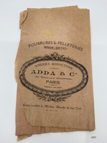
Container - Brown paper shopping bag from Adda & Co. Paris, c. early 20th century
Adda & Co operated a business at 52 Boulevard Haussmann, Paris.The store sold crocheted silks, furs and hides. History of shopping bags: Before the late 1800s, shopping bags didn’t exist. Shoppers would either carry their goods home in baskets, or have the merchant deliver them to people's homes, until 1852 when Francis Wolle, a schoolteacher in Pennsylvania, invented a machine to produce paper shopping bags. This invention would allow customers to carry items home in disposable paper bags. Soon after, owners of department stores and retailers began to realise that paper shopping bags could be used to help market their brands, and as such custom shopping bags with printed logos became common place. Carrying a shopping bag from certain shops became a type of status symbol for consumers, providing evidence that one was well-off, had good taste, or both.The paper shopping bag is a rare survival of ephemera related to a retail store called Adda &Co that operated at 52 Boulevard Haussmann, Paris. The arrival of waves of more than ten million migrants by boat is one of the major themes in Australia’s history. The paper shopping bag is representative of personal items purchased for migrant journeys as markers of domesticity, warmth and making oneself at home in a new land that speaks of the transnational lives embedded in threads of migration.A brown paper shopping bag with a printed logo and store information in black inkparis, department store, shopping, adda & co, flagstaff hill, maritime museum -
 Eltham District Historical Society Inc
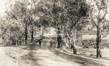
Negative - Photograph, Bridge on Main Road, Eltham, c.1890
Possibly produced as a postcard. Caption in lower right hand corner reads: Bridge (at) Main Road Eltham. The long wooden suspension bridge over the Diamond Creek on Main Road at Eltham collapsed during flooding of the Diamond Creek on October 13 and 14, 1923. The original bridge was built around 1840 for the coach road when Cobb & Co.'s coach was the only conveyance between Eltham and Melbourne. Widespread damage was done in Melbourne and surrounding areas by floods resulting from the overflow of the Yarra at many points along its banks. A temporary bridge rigged up was severely damaged by the flooding of the creek and was closed to vehicular traffic in April 1924. A new concrete bridge was constructed to replace it and by May 1926 all the concrete piles and abutments had been completed. The bridge was finally completed and opened for traffic in September 1926, almost three years after it initially collapsed. Viewed from Antoinette Boulevard looking northwest towards Falkiner Street. The building in the distance believed to be Souters Cottage. On the far right on the very edge of the road verge are two Eucalypt trees, one of which is believed to be the large dead trunk still standing in present day.This photo forms part of a collection of photographs gathered by the Shire of Eltham for their centenary project book,"Pioneers and Painters: 100 years of the Shire of Eltham" by Alan Marshall (1971). The collection of over 500 images is held in partnership between Eltham District Historical Society and Yarra Plenty Regional Library (Eltham Library) and is now formally known as the 'The Shire of Eltham Pioneers Photograph Collection.' It is significant in being the first community sourced collection representing the places and people of the Shire's first one hundred years.Digital image 4 x 5 inch B&W Neg Black and white print 35mm positive transparencyshire of eltham pioneers photograph collection, eltham, main road bridge, eltham south, bridge, diamond creek (creek), significant tree, souters cottage, eltham lower park, main road, sepp -
 Eltham District Historical Society Inc
Photograph - Photograph postcard, The Rose Stereograph Company, View at Eltham, Vic. Postcard sent from Ernest and family to Joe, 3 May 1936, c.1920
Postcard sent from Ernest and family to Joe, 3 May 1936. Original photo estimated to be circa 1920. Looking west across the original Main Road Bridge and the Diamond Creek from near the intersection of Antoinette Boulevard. To the right of the bridge appear to be orchard trees in flood waters. The long wooden suspension bridge over the Diamond Creek on Main Road at Eltham collapsed during flooding of the Diamond Creek on October 13 and 14, 1923. The original bridge was built around 1840 for the coach road when Cobb & Co.'s coach was the only conveyance between Eltham and Melbourne. Widespread damage was done in Melbourne and surrounding areas by floods resulting from the overflow of the Yarra at many points along its banks. A temporary bridge rigged up was severely damaged by the flooding of the creek and was closed to vehicular traffic in April 1924. A new concrete bridge was constructed to replace it and by May 1926 all the concrete piles and abutments had been completed. The bridge was finally completed and opened for traffic in September 1926, almost three years after it initially collapsed. The Rose Series P. 4346 Postcards scanned from the collection of Michael Aitken on loan to EDHS, 13 Feb 2018Digital file only Postcards scanned from the collection of Michael Aitken on loan to EDHS, 13 Feb 2018michael aitken collection, postcards, main road bridge, main road, eltham, antoinette boulevard, diamond creek (creek), eltham south -
 Wodonga & District Historical Society Inc
Memorabilia - China Souvenir Jugs Woodland Grove Wodonga, c. 1940
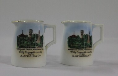
A wide range of small china pieces carrying scenic views of holiday destinations or key locations were a popular kind of souvenir during much of the 20th century. Several different pieces were used to depict Wodonga during this period, primarily focusing on the Woodland Grove and the Soldier Memorial. In 1924, Arthur Arnold and his father Wilhelm Arnold had established a general store in High Street, near the water tower, but in 1931–32 they moved to new premises in High Street on the corner of what is now known as Elgin Boulevard. In 1933-34 they widened the frontage of the shop and added new premises at the rear for the sale of produce. As customer debt mounted during the depression, it became difficult for Arthur and Wilhelm to re-stock the shop, so they enticed customers into paying their accounts by rewarding them with a small individual cream or milk jug upon payment. The jugs were made in Czechoslovakia and displayed the war memorial, water tower and bandstand from Woodland Grove, Wodonga. The Arnolds continued to trade until they finally closed their store in 1950. Wilhelm Arnold was a brother of J G Arnold, whose business ultimately became the present-day Arnold’s Fruit Market, Wodonga. This item has local historic and social significance as it depicts which features of the city the community valued in the past. It has artistic significance as an example of the kinds of souvenirs used widely across Australia to represent communities and the landscape.A pair of miniature white jugs with a gold rim and handle detailing. A hand-coloured transfer image fills the front side depicts Woodland Grove Wodonga, including the Soldiers' Memorial, Water Tower and RotundaBeneath the image : "WOODLAND GROVE, VIC. / With Compliments/ from/ A. Arnold & Co."wodonga, souvenirs, woodland grove, ceramics, arnolds wodonga -
 Melbourne Legacy
Postcard, Postcards of Egypt
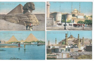
Postcards were a common form of souvenirs for soldiers who were travelling either during World War 1, or just after, or while returning to Australia. These postcard scenes include the Sphinx, the Pyramids, Cairo, Alexandria, and Suez including mosques and marketplaces. The Suez Canal was used by troop ships, so this was often the first time soldiers from Australia saw Egyptians. Many troops in World War 1 were stationed first in Egypt (including near Cairo) to train before heading to Gallipoli, Turkey or on to the Western Front. These were with other World War 1 memorabilia that has come from Private John Basil McLean, 2nd Reinforcements, 37th Battalion, A.I.F. There was a large collection of postcards so he may have been collecting them as souvenirs (none of these have been written on or posted). He also had a vesta (match) case from Belfast, so it is likely he visited there. J.B. McLean (Service No. 13824) was from near Maffra, Victoria and enlisted on 22 January 1916. He embarked on 16 December 1916 for Europe. His full war record is available from AWM. He spent time with the Australian Field Artillery (Pack Section). At the end of the war he worked for a year at the A.I.F. Headquarters in London before returning to Australia on the 'Ceramic', arriving Portsea in 1920.Postcards were a very common form of communication in the first World War. Postcards as souvenirs or as correspondence would have been familiar to the first Legatees as they had served in World War 1. These places in Egypt could have been visited by the first Legatees when they were soldiers in World War 1.Postcards x 16 with images from Cairo, Alexandria and Suez in Egypt and a purple card holder that once contained 12 views of Suez (only 3 here).01137.1 Cairo - Sphinx and Pyramids 01137.2 Cairo - Arab Village near the Pyramids 01137.3 Cairo - The Citadel 01137.4 Cairo - General View of the Citadel 01137.5 Cairo - Sebil of Abbassia 01137.6 Cairo - Barrage Bridge 01137.7 Cairo - Native Woman 01137.8 Suez - Market Street 01137.9 Alexandria - San Stefano Casino 01137.10 Alexandria - Native Bazaar new Napoleon's Fort 01137.11 Alexandria - Mohamed Aly Place 01137.12 Alexandria - The Light House 01137.13 Alexandria - Column of Menasce 01137.14 Alexandria - Ramleh Boulevard 01137.15 Suez - The Port -Twefik Quay 01137.16 Suez - Railway Station Each one has the word POST CARD on the reverse with room for an address and an area for Correspondence. Different makers.souvenir, world war one -
 Wodonga & District Historical Society Inc
Photograph - Codling Collection 01 - The Finishing Touch (previously Arnold’s Produce Store)
Miss Olive Codling was a Foundation Member and a Life Member of the Wodonga Historical Society. Many of her prize-winning photos are held in the Society Collection. She also held a range of roles and committee positions in a wide range of Wodonga community organisations. These included the Horticultural Society, the Wodonga Arts Council, the Wodonga Camera Club and the Wodonga Lapidary Club. This photo collection is significant as it documents how the businesses and buildings in Wodonga have evolved and contributed to community throughout the 20th century.The Finishing Touch, homeware and gifts on the corner of what is now High and Elgin Street. Including John Penny’s Sewing Centre and sewing machine service. At various times it has also been occupied by Elders Real Estate and Jim Matthew's cycles A "Malvern Star" sign is still visible in this photo. It was also previously A. Arnold & Co, General Merchant. In 1924, Arthur Arnold and his father Wilhelm Arnold had established a general store in High Street, near the water tower, but in 1931–32 they moved to new premises in High Street on the corner of what is now known as Elgin Boulevard. In 1933-34 they widened the frontage of the shop and added new premises at the rear for the sale of produce. As customer debt mounted during the depression, it became difficult for Arthur and Wilhelm to re-stock the shop, so they enticed customers into paying their accounts by rewarding them with a small individual cream or milk jug upon payment. The jugs were made in Czechoslovakia and displayed the war memorial, water tower and bandstand from Woodland Grove, Wodonga. The Arnolds continued to trade until they finally closed their store in 1950. Wilhelm Arnold was a brother of J G Arnold, whose business ultimately became the present-day Arnold’s Fruit Market, Wodonga. wodonga businesses, high st wodonga, the finishing touch, a arnold general merchant -
 University of Melbourne, Burnley Campus Archives
Album - Digitised, Joanne Morris, Visit to Burnley April 2014, 2014
Collection of digitised photographs taken in preparation for the Class of 1973 Reunion in 2014. Garden views and buildings. Donated by Joanne Morris, former student, in June 2014. See Digitised photos- Garden Views folder- Visit to Burnley April 2014. (1) Luffmann Ponds. (2) Administration Building. (3) Emily Gibson Beds and Ginkgo biloba. (4) Looking towards Native Garden. (5) Oak tree. (6) Looking towards Rose Garden. (7) Looking towards Stream Garden and Fern Garden. (8) Looking towards Rose Garden. (9) Plaque at entrance to Field Station. (10) New gates at entrance to Field Station donated by the Friends of Burnley Gardens. (11, 12) Field Station. (13) Plaque in Herb Garden commemorating Enid Carberry. (14) Fountain in Herb Garden commemorating Enid Carberry. (15) Forestry Building. (16-18) Inside Forestry Building. (19) Sugar Gum Table Setting donated by the Friends of Burnley Gardens. (20) Plaque on Sugar Gum Table commemorating Geoff Olive. (21, 22) View of Luffmann Ponds and Summer House. (23) Plaque at Luffmann Ponds. (24) Luffmann Ponds. (25) View of former Egg-Curator's Residence from Nursery. (26) Back of Nursery. (27,28) The Burnley entry for the Melbourne International Flower and Garden Show 2014. (29) Back of Administration Building. (30) Plant Science Laboratories. (31) Student Amenities Building. (32-34) Plant Science Laboratories. (35) Citriodora Court. (36) Eucalyptus maculata at entrance to Native Garden. (37) Native Garden, James Hitchmough Grasslands. (38) Garden view. (39) Inside the Hall. (40,41) Roof Garden. (42,43) Library. (44-50) Views of the Quad and classrooms. (51) Dairy. (52) Building 904,(Centre for Urban Horticulture) now Waterway Ecosystem Research Group. (53) Yarra Boulevard entrance.class 1973, class reunion, garden views, buildings, joanne morris, students, luffmann ponds, administration building, emily gibson beds, ginkgo biloba, native garden, oak tree, rose garden, stream garden, fern garden, field station, friends of burnley gardens, plaques, herb garden, enid carberry, fountain, forestry building, sugar gum table, geoff olive, summer house, egg-curator, residence, nursery, melbourne international flower and garden show, 2014, plant science laboratories, student amenities building, citriodora court, eucalyptus, james hitchmough grasslands, roof garden, library, quad, classrooms, dairy, centre for urban horticulture, waterway ecosystem research group, yarra boulevard entrance -
Surrey Hills Historical Society Collection
Work on paper - Vertical file, COVID-19
A vertical file containing the following information: 1. ‘Supporting Victorians Through Covid-19’ from Josh Frydenberg (undated) (brochure). 2. ‘Important information about Coronavirus’ from Josh Frydenberg (undated) (brochure). 3. ‘A COVID-19 message from your local MP’, Paul Hamer State member for Box Hill, August 2020. (Envelope, letter and drawing to colour in). 4. Back to work and back to business, brochure from Matt Bach, MP, November 2020 (?). (1 sheet). 5. ‘The Boulevard Food Store and COVID19’; ‘Our travel is paused, but our dreams are alive’; ‘We are all in this together’; SHNN No. 226, June/July 2020. (1 page). 6. ‘Flowers for a crazy world’, SHNN No. 226, June/July 2020. (1 page). 7. ‘Staying positive’, SHNN No. 226, June/July 2020. (1 page). 8. ‘Art Style Gallery celebrates five years in Union Road’, SHNN No. 226, June/July 2020. (1 page). 9. ‘Staying at home in lockdown’, SHNN No. 226, June/July 2020. (1 page). 10. ‘Reflections on COVID-19 and our community’, SHNN No. 226, June/July 2020. (1 page). 11. Bread Street ‘Notice to our clients end of meals on wheels programme’, 21.12.2020, 2 copies (1 page). 12. ‘Meals on Wheels, from Bread Street’, SHNN No. 226, June/July 2020. (1 page). 13. ‘Probus – enriching our lives, expanding our horizons during COVID-19 restrictions’, SHNN No. 228, Oct./Nov. 2020 (1 page). 14. ‘Surrey Hills Neighbourhood Centre Tai Chi Group’, SHNN No. 230, Feb./March 2021. (1 page). 15. ‘Jab, jab, the spring into life again’, and ‘Bare your arms for Hung Le, our local pharmacist’, SHNN No. 234, Oct./Nov. 2021. (1 page). 16. ‘Important information you need to know about COVID-19’, Boroondara Update, Edition 4, June, 2020 (1 page). 17. ‘COVID-19 restrictions’, Boroondara Bulletin, August, 2020 (1 page). 18. ‘Schools return!’, SHNN No. 236, February, 2022 (1 page). -
Surrey Hills Historical Society Collection
Work on paper - Vertical file, COVID-19
1. ‘Supporting Victorians Through Covid-19’ from Josh Frydenberg (undated) (brochure). 2. ‘Important information about Coronavirus’ from Josh Frydenberg (undated) (brochure). 3. ‘A COVID-19 message from your local MP’, Paul Hamer State member for Box Hill, August 2020. (Envelope, letter and drawing to colour in). 4. Back to work and back to business, brochure from Matt Bach, MP, November 2020 (?). (1 sheet). 5. ‘The Boulevard Food Store and COVID19’; ‘Our travel is paused, but our dreams are alive’; ‘We are all in this together’; SHNN No. 226, June/July 2020. (1 page). 6. ‘Flowers for a crazy world’, SHNN No. 226, June/July 2020. (1 page). 7. ‘Staying positive’, SHNN No. 226, June/July 2020. (1 page). 8. ‘Art Style Gallery celebrates five years in Union Road’, SHNN No. 226, June/July 2020. (1 page). 9. ‘Staying at home in lockdown’, SHNN No. 226, June/July 2020. (1 page). 10. ‘Reflections on COVID-19 and our community’, SHNN No. 226, June/July 2020. (1 page). 11. Bread Street ‘Notice to our clients end of meals on wheels programme’, 21.12.2020, 2 copies (1 page). 12. ‘Meals on Wheels, from Bread Street’, SHNN No. 226, June/July 2020. (1 page). 13. ‘Probus – enriching our lives, expanding our horizons during COVID-19 restrictions’, SHNN No. 228, Oct./Nov. 2020 (1 page). 14. ‘Surrey Hills Neighbourhood Centre Tai Chi Group’, SHNN No. 230, Feb./March 2021. (1 page). 15. ‘Jab, jab, the spring into life again’, and ‘Bare your arms for Hung Le, our local pharmacist’, SHNN No. 234, Oct./Nov. 2021. (1 page). 16. ‘Important information you need to know about COVID-19’, Boroondara Update, Edition 4, June, 2020 (1 page). 17. ‘COVID-19 restrictions’, Boroondara Bulletin, August, 2020 (1 page). 18. ‘Schools return!’, SHNN No. 236, February, 2022 (1 page). -
 University of Melbourne, Burnley Campus Archives
Album - Colour slides, Burnley Views, 1956-1969
Contributor: T.H. KneenBox of 47 slides, some labelled. (1) "Marjorie Hall 1st Year Student June '56 No. 1872." Working with fruit tree stock. (2) "Orchard June 1956 No. 1710." 2 men and a tractor.(3) "Camp 1957." Wilson's Promontory. (4) View of Drive No. 1677." C. 1958 (5) "GenView No. 1771." (6) "Burnley Gardens Entrance 4.4.58 N0. 1672." (7) "Wilson's Promontory Lilly Pilly Gully Nov 1960." (8) Dec '62." (9) "Dec '62." Kneen child. (10) Luffmann Ponds "Aut. 1962." (11) Grevillea Sep 1963. (12) Sep 1963.Reflection of Crack Willow in Luffmann Ponds. (13) Sep 1963. Orchard blossom. (14) View of Administration Building at sunset Aug 1964. (15) Rose 'Heat Wave.' May 1965. (16) Kneen child sitting under a tree May 1966. (17) 'Department of Agriculture Burnley Gardens' sign May 1966. (18) Administration Building May 1966. (19) Plant Science Block May 1966. ((20) Wintersweet August 1966.(Actually appears to be Witch Hazel Hamamelis mollis.) (21) Student on tractor in the Orchard October 1966. (22) Garden view, view of Principal's Residence through blossom trees October 1966. (23) Students walking through the Gardens October 1966. (24) "Leaf Cuttings Rex begonia 2 October 1966. (25) Emily Gibson beds October 1966. (26) Principal's Residence in a garden view October 1966. (27) Garden view looking towards the Principal's Residence and the Shady Garden October 1966. (28) Drive looking towards the Administration Building from the Plant Research Institute. (29) Kneen child (not Burnley?) (30) Unveiling of Burnley Horticultural College plaque commemorating 75 years, 1891-1966 - Eric Littlejohn, ?, T.H. Kneen. Includes key to Pavilion 1969. (31) "Rose Pruning Demo - Canteen." July 1969. (32, 33) "Rose Pruning Demo 1969." July 1969. (34) "Plant Science Block & College." July 1969. (35) Plant Science Block 6/69." July 1969. (36) "Burnley Gardens 6/69." looking towards Dairy and Yarra Boulevard (37) "Pond No. 1717." (38) "Pond 1748." Kneen children playing by the Luffmann Ponds, Oak tree behind.. (39) Ginkgo leaves June 1967. (42) ? (43) Erithyna caffra in flower (removed 2016) December 1966. ((44) Administration Building and Nursery from PRI." (45) Pelargoniums. (46) Azalea mollis (47) Pelargonium foreground, geranium background.marjorie hall, students, fruit trees, orchard, tractor, wilson's promontory, burnley gardens, entrance, drive, garden view, luffmann ponds, grevillea, rose, kneen family, sign, wintersweet, plant science block, administration building, students working outside, principals residence, plaque, rose pruning demonstrations, ginkgo, pelargoniums, erythryna -
 University of Melbourne, Burnley Campus Archives
Document - Personal files, Andrew Smith's Files, 1981-2022
cactus, cacti, clematis, orchard redevelopment, r. hall, geoff olive, pruning garden, field station, vcah, university of melbourne, burnley, jill kellow, field station redevelopment, field nursery, student gardens, turfgrass, grassy woodland, chris findlay, phil tulk, grasslands, herbaceous border, car park, native garden, restoration native garden, john rayner, hilda kirkhope rockery, herb garden, rainforest garden redevelopment, plant lists, shady walk, salvia, trees, tai-haku cherry, tree management, tree lists, david aldous, grey border -
 Eltham District Historical Society Inc
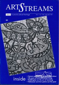
Journal, Peter Doughtery, ArtStreams: News in arts and cultural heritage; Vol. 1, No. 2, Dec 1996/Jan 1997, 1996
Vol. 1, No. 2 Dec 1996/Jan 1997 CONTENTS ADVENTURE WITH COLOUR Teenage cancer patients challenge their illness with art 3 CD REVIEWS New music by local musicians 5 LIVE AND LET LIVE 20 years of environmental living 6 AUSTRALIA REVISITED Artist Charles Reddington ponders live 30 years on 8 POETRY REVIEW Anne Delaney looks at new work by Jennifer Harrison and Jordie Albiston 11 PHOTOGRAPHY Katherine Jones aims at hard edges 16 IMAGES FROM A DARK PAST Holocaust survivor paints out a traumatic part of his life 18 MORALITY OF JUSTICE The Truth Game - a play by Ray Mooney 21 ART FROM THE HEART An exhibition that crosses boundaries 22 SHORT STORY New story from an emerging writer 25 ART IN THE CEMETERY Darebin launches a new project to decorate its new mausoleum 28 LISTINGS Artists, performers and galleries 29 KEYWORDS 895 Main Road, 1994 Moet et Chandon Fellowship, Adventure with Colour, Alan Bonney, Alan Constable, Alun Leach-Jones, Amada Laming, Anne Connor & Associates, Anne Delaney, Anthony Day, Art Streams Magazine, Artist-in-residence, Arts by the Waters, Arts project Australia, Auschwitz, Banyule Jazz Festival, Barbara Veheary, Bend of Islands Conservation Association (BICA), Bend of Islands Estate, Bend of Islands, Bill Downing, Bulleen Art & Garden Centre, Bulleen Nursery, Caffe Poco, Carlton Courthouse Theatre, Catani Boulevard, Catherine Oxley Reserve, Charles Reddington, Charlie Dowley, Cheryl Daye, Chris McAuliffe, Clifton Pugh, Colin Lanceley, Cornelia Selover, Creativitie et Handicap Mental (CREAHM), Cynthia Hardman, Cyril Tawney, Damian Eyre, Daniel Lillford, Danuta Michalska, Darebin Arts and Entertainment Centre, Darebin City Council, Department of Fine Arts, Donald Campbell, Dora Zable, Dorothy Berry, dunmoochin, E.H. Cameron, Edward (Ned) Haughton, Edward Car, Elizabeth Vercoe, Eltham High School, Eltham Living and Learning Centre, Environmental Living Zone (ELZ), Eric Bogle, Eucalypso, Felix Tuszynski, Food For All Seasons, Frank Hodgkinson, Fulli Andrinopoulos, Gallery of Georges of Collins Street, Gallery of Slavic Art, Glen Agnes Bend of Islands Estate, Glen Agnes Estate, Gongflers drive, Greg O'Leary, Harold (Jimmy) Fuller, Helen O'Grady Children's Drama Academy, Henley Road, Ian Doolan Hamilton, Ian Gawler, Inside Out/Outside In, Ironbark Road, Janice McBride, Jennifer Harrison, Jennifer McGregor, Jessie Agnes Haughton, Jimmy Pike, Joan Blakey, John Mackay Northe, John Rasmussen, Jordie Albiston, Julian Martin, Kangaroo Ground, Katherine Jones, Kelvin Heffernan, Kew Coattage, Kitty Ginter, Lavita Mossop, Les darcy, Les Gyori, Life with Jane, Lorraine Larter, Luc Boulange, Luciana Giardina, Manningham Artspace, Manningham City Council, Mariann Moxon, Mark Capozzi, Mark Chapman, Mark Wilkinson, Maxine Ryder, Melbourne Police Pipe Band, Mick Woiwod, Mike O'Rourke, Monica Burns, Montsalvat, Myra Hilgendorf, Nancye Ball, Page family, Pam Crohan, Pam Dougherty, Poetry, Preston Public Cemetery, Ray Mooney, Richard Haese, Robert Hughes, Robyn Kirkpatrick, Roger Lemke, Ron Hanson, Sandra Harvey, Shire of Eltham Office site, Shire of Healesville, Shire of Nillumbik, Shire Offices, Sounds by the Waters, Stelio Costa, Steven Tynan, Steven Worrell, Stewart Whiffin, Sue Howard, Sue Whiffin, Sugarloaf Reservoir, Sydney Ball, The Art of Australia, The Mews, The Truth Game, Tom Fantl, Tony Inglese, Tuszynski Survey Exhibition, University of Melbourne, Valerio Ciccone, victorian artists supplies, Watson Creek Bridge, Watsons Creek, Wayne Marnell, Woody Guthrie, Yarra Brae Dam, Yarra River"Peter Dougherty has been involved in the local art scene for many years. As publisher and editor of the arts magazine Artstreams, his comments on the various branches of the arts are widely respected. His "The Arts" column in the Diamond Valley Leader presents a brief summary for a much wider cross section of the local community. Peter also operates his own gallery and the Artstreams Cafe at the St Andrews market. Peter has a wealth of knowledge about present day and historical aspects of local art and artists." - Eltham District Historical Society Newsletter No. 161, March 2005Colour front and back cover with feature articles and literary pieces with photographs and advertisements printed in black and white. 36 pages, 30 cm. Vol. 1, no. 1 (Nov. 1996) - Vol. 10, no. 5 (summer ed. 2005/06) art streams, feliz tuszynski, elizabeth vercoe, eucalypso, bend of islands, charles reddington, jennifer harrison, jordie albiston, katherine jones, anne bonney, mick woiwood, anne connor, anne delaney, ray mooney, pam dougherty, arts project australia, lavita mossop, preston public cemetery, helen o'grady children's drama academy, bulleen nursery -
 Melton City Libraries
Map, Streets of Melton, 1963
MELTON’S STREETS Heritage Week 2014 What’s in a Name? Alphabetical List Aboriginal place names, Early Family Names and landowners, Agricultural, Shop and Commercial premises, Places and Events Melton & District Historical Society Street Naming Project 1972 – c 1998 Suburb Name – KURUNJANG - Kirkton, 1972, Brookfield, West, 1988 Melton and Town Centre - A joint collaboration with the Shire of Melton and Subdivision Developers ARNOLD Court – Family house - Arnolds Creek ALKEMADE Drive Family – Lime kilns Coimadia ALEXANDRA Street 1902 – Corination of King Edward VII and Queen Alexandra AVIATOR Place Event, location of plane crash – Jimmy Melrose 1936 Adina ?Annibee - Anniba? Agricultural Avon court .. .. BAKERY Square - Location of Jongebloed shop, bakehouse and stables BALUK Place Aboriginal BARLEYCORN Place Agricultural BILLING Place Name of Jimmy Melrose Uncle Noel Pemberton Billing BLACKWOOD Drive - Alexander Blackwood 1860c Registrar BARRIES Road C. E. Barrie “Darlingsford” farmer 1911, chaff mill owner BROOKLYN Road Staughton family residence. 1875 – Dismantled c 193? CAHILL Drive Family - Glenville Dairy CAMERON Court Family Canopus Place ? CANALLAN Drive Early Surveyor CAMPBELL Court Aviation – Melrose passenger 6th July 1936 CARBERRY Drive Michael, early landowner family CAREW Court Edward and Michael. Royal Hotel. Vera (Carew) Forran Singer - Opera CASEY Court Family CASHIN Court Family CHEVIOT Court Agriculture, breed of sheep CHESNEY Road was re named ( Minns Road being duplicated c 1973) CHRISTINA Crescent Christina McPherson, daughter of James and Mary Mary McPherson. Died 1955 aged 85 years COLLYER Close a deleted street (parallel to Yuille) re-used CORRIEDALE Road Breed of sheep CORR Court Teacher at first school, landowner CROXTON Court Name of the Hornbuckle and Knox family home DALEY Court - William Daley and family 1865 Bootmaker High Street DARLINGSFORD Boulevard - Name of early homestead Thomas B Darling 1853 DJERRIWARRH Court - Parish County of Bourke - very early map. DODEMAIDE Place Early land owners - Melton Football Team had 6 brothers playing c 1924 DONALD Court McPherson family 6 generations in Melton in 1936 DOUGAL Court DUNCAN Court .. .. DUNVEGAN Circuit Home of the McPherson family, castle Isle of Skye Name of bluestone house Smith Street (now at Willows) EMIL Court Jongebloed family EXELL Avenue Farming family Melton Sth- Closer Settlement 1907 EXFORD Road Exe former name of the Werribee river FARMER Court Name of early postmistress FERRIS Road John Ferris Farmer HANNAH Close First name of Hannah Watts – midwife HAYBALE Place Agricultural HELDER Court Early surveyor J Helder Wedge map HEWSON Street Winston Hewson Shire Engineer – check title c 1960 HENRY Street Township map c 1860 HESTON Street Heston Phoenix – C.J. Melrose plane HILDEGARDE Court Jimmy Melrose’s mothers name HOMESTEAD Close HORNBUCKLE Cres Farmers. Three members of family - Shire Presidents HURLEY Street Farmers IAIN Court Descendent of James and Mary McPherson JAMES MELROSE Drive Name appears on 2013 Melton information map JANG Place KURUN – jang KIRKTON Drive Name of the McPherson family home Toolern Vale Road KIRWIN Street Michael early landowners (deleted for freeway construction) KILPATRICKS Road Deleted when Barries Road was extended across Station Rd KOROROIT Court Early map, Parish of Kororoit. Creek name KNOX Circuit Family – Hornbuckle “Croxton Park” KURRUNJANG Drive Aboriginal name for people of the red earth – Suburb name Lara Place ? LLOYD Court Garage owners High Street. Laura lived to 100 years D 1955 LUBY Court John Luby – Crown Grant Land Title LITTLE Court MANNING Avenue Richard, hotel owner 1891 MARGARET Drive McPherson family McDONALD Street Melton South family name McKENZIE Street Township c1860 MORROW Street Early name MOWBRAY Crescent Name of English Melton, popularly believed origin of Melton MYERS Court Early setters c 1866 Crown Grant Land Title NIMMO Street Early name NIXON Street Name submitted by Mary nee Nixon Collins c1985 OLDERSHAW Road Early builder PALMERSTON Street Early township map c 1860 PEART Court Early name PENNYROYAL Avenue Plant growing by the creek. Early name used for the Toolern Toolam Creek PINKERTON Street Family name and early street map PINNACLE Crescent Agricultural - type of wheat PHOENIX Circuit C.J. Melrose Phoenix Heston Plane 2013 map PRATT Family PRIOR Court PYKE Place Brothers – early settlement 1838 RADFORD Court Land owners and business operators. Former Royal Hotel Grocer High Street demolished 1970 RAGLAN Court Hotel 19th century Lord Raglan RALEIGHS Road Oliver Reierson family (Norweigen) Shopkeeper – Dressmakers RIDDELL Drive (misspelt Riddle) Resident and land owner RODERICK Road McPherson family – a re occurring name ROLLAND Court Jones family ROSS Court Daniel. Landowner. Agnes Ross music teacher RUSSELL Court Robert. Early land surveyor of Melton 1853 RYAN Court Family early landowner. Member of the 1862 Road Board SHEBLER Place Augustus early Melton resident – Golden Fleece Hotel SHEEPFOLD Court Farming SHERWIN Court Sherwin Street earliest Township map– became Golf course SMITH Street Early township map. STRATHULLOH Circuit Strathtulloh Homestead. STAUGHTON Street Family – LARGE land owners Strachan ? SWANEY Court Marie Swaney earlier resident of Strathtulloh. SUTHERLAND Family name TOOLERN Street TOOLAM – TOOLERN Creek TULLIDGE St Road marked on 1861 map UNITT Street Early Township c 1860 WALLACE Square Cr Jack Wallace 5 terms as President 46 years unopposed WATTS Court Hannah Watts – midwife, cottage hospital WALSINGHAM Name of house of Minns family. From Walsingham Norfolk England WESTLEY Place Name of Jimmy Melrose Percival Gull Plane WESTLAKE Drive Early resident WHICKHAM Street Family Name Melton South WILSON Road Albert, Melton South YUILLE Street William Cross, early landowner, Rockbank run Zoomed in section of Melton Streets including Church and High Streetlandscapes of significance