Showing 366 items
matching tourist information
-
 Kiewa Valley Historical Society
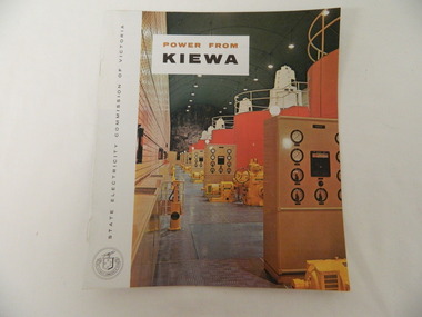
Booklet - S.E.C.V. x2, Power from Kiewa
The State Electricity Commission of Victoria constructed the Kiewa Hydro Electric Scheme. Their public relations employees published booklets to promote the Scheme and the area. In this booklet there are photos of some of the major work constructions with an explanation of how they work and their purpose, a map of the Scheme and an article and photos of tourist facilities and activities that are available.This booklet promotes the Kiewa Hydro Electric Scheme and tourism indicating that tourism was recognised as a new industry for the area. The photos give a pictorial history of the area eg. skiing using the Summit T-bar lift and includes the facilities available at the time. The explanation of the Kiewa Hydro Electric Scheme is a basic resource for students interested in Hydro power.Slim booklet with photo of McKay Creek Power Station on the front cover and the title in brown and black at the top. Printed along the spine is State Electricity Commission of Victoria.state electricity commission of victoria. kiewa hydro electric scheme. tourism. t-bar ski tow. falls creek -
 Kiewa Valley Historical Society
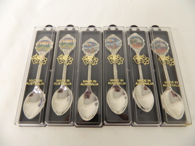
Spoons - Souvenir, Mt Beauty x6
Souvenirs are sold to tourists as a moment of their visit to Mt BeautyMt Beauty is a tourist town6 spoons - 2 of each with a different picture. Silver spoon in a plastic case. The case has a black side with a ring at the top and 2 small pieces that jut out from inside to hold the spoon. The clear front cover fits on and has gold embossing. The stem of the spoon is embossed with lines on the front. At the end there is a circular coloured picture with 'Mt Beauty' below surrounded by embossed decoration.Cover: Map of Auistralia with ASM along the W.A. side / Made in / Australia Spoon: top of handle - Mt Beauty. back of handle - embossed kangaroo. back of stem - 'Swann and Hudson Made in Australiamt beauty. souvenir. silver spoon. tourism. swann and hudson -
 Kiewa Valley Historical Society
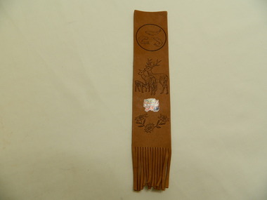
Bookmark - Souvenir, Mt Beauty
Bookmarks are sold as souvenirs to tourists to remind them of their holiday. Mt Beauty is a tourist town.Soft brown leather strap with circle around 3 fish at the top, 3 deer in the middle and 3 flowers at the bottom. Frilled at the bottom end. Between the deer and flowers is a coloured picture with 'Mt Beauty' across the middle.Mt Beautysouvenir. mt beauty. bookmark. tourism -
 Kiewa Valley Historical Society
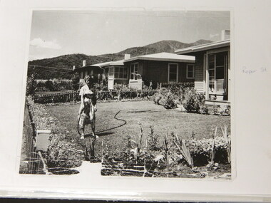
Folder - Early Photos of Mt Beauty
Mt Beauty township was built during the 1950's to house the employees of the State Electricity Commission working on the Kiewa Hydro Electric Scheme. After the completion of the Kiewa Hydro Electric Scheme many houses were sold and the public buildings handed over to the Alpine Shire. Mt Beauty has always been a tourist destination especially with its proximity to the ski fields at Falls Creek.This folder contains many early photos of Mt Beauty showing the construction town during its development during the Kiewa Hydro Electric Scheme and its early days of tourism. A3 size black plastic folder with clear plastic sleeves holding early black & white photos of Mt Beauty township. Also included are: 1. 3 foolscap pages -Nov., 1953 Kiewa Hydro-Electric Scheme Progress. 2. SECV Drawing Plan (No. K6242) of Mt Beauty House - 3 angles and floor plan, English Pre-cut Type 3B.ILA with note that all houses with prefix 3B are similar. 3. Orange, black and white pamphlet "Welcome to Kiewa" 4. Tourist postcard 'fold-up' of 11 postcards "Mt Beauty and the Kiewa Scheme, Victoria 5. Drawing Plan of 'Mt Beauty Housing. Use of Prefabricated Cubicles for Houses. Type C.1 6. Drawing Plan of 'Kiewa Scheme Mt Beauty Housing Type "G". 7. 5 pages on "Twelve Tips on Caring for Old Buildings 8. Booklet advertising Mt Beauty housing for sale including activities available in the area. (1960's) 9. List of Photos from SECV held by KVHS Some photos have handwritten labels mt beauty. secv. kiewa hydro electric scheme.tourism. housing. construction town. falls creek. -
 Kiewa Valley Historical Society
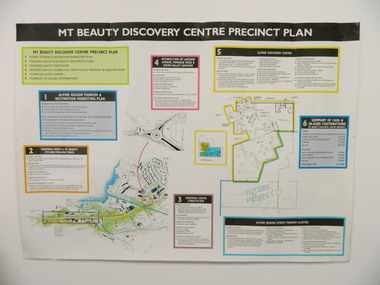
Poster - Mt Beauty Discovery Centre Precinct Plan
The current (2015) Mt Beauty Tourist Centre site was to be upgraded into a 'Sports Tourism Cluster' with funding from the Government and the Alpine Shire with 'In Kind' assistance from Falls Creek Resort management Board, Parks Victoria and the Local Community & Tourism Industry. This project didn't go ahead.The Mt Beauty town was handed over to the Alpine Shire in the 1960's after completion of the Kiewa Hydro Electric Scheme. Plans for up dating facilities are on-going but are rarely completed. This poster is an example of this.Very large laminated poster depicting 6 points for the Alpine Region Sports Tourism Cluster. Each point has a coloured border and background to black writing. There are 3 maps.mt beauty. tourism. discovery centre. sports cluster. -
 Warrnambool and District Historical Society Inc.
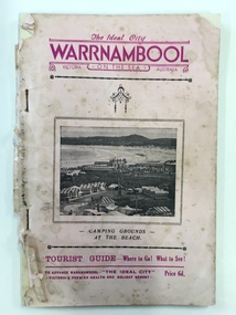
Booklet - The Ideal City Warrnambool On the Sea, Modern Print, 1940
... information on the tourist attractions of Warrnambool and district... information on the tourist attractions of Warrnambool and district ...This booklet has been issued in 1940 by the Warrnambool Progress and Tourist Association established in 1927. Warrnambool was the winner of the Sun News Pictorial Quest in 1928, the ‘Ideal City’ and used this title to promote the city. There had been several Tourist Associations in Warrnambool prior to 1927 and all of them promoted Warrnambool as a health resort and an ideal holiday destination with the Sea Baths in Gilles Street and the beach close by. This guide has been produced during World War Two with rationing of petrol and other goods and most people in Victoria would not have been contemplating long and expensive holidays so Warrnambool with its rail service and beach facilities would have been seen as a possible holiday destination. This Warrnambool Tourist Guide is of considerable interest both for its content regarding Warrnambool’s attractions in World War Two and for its 1940s advertisements and photographs. This is a booklet of 33 pages stapled together. It is a Warrnambool Tourist Guide from the 1940s. The pages are mostly white but there are a couple of blue and buff-coloured pages. The cover is pink with mauve and black printed material and a photograph on the front cover of the Warrnambool camping ground on the foreshore. The back cover has become detached. The booklet contains information on the tourist attractions of Warrnambool and district, black and white photographs of buildings, events and scenic spots and advertisements for local businesses. Many of the advertisements also contain photographs of business premises. Front Cover: ‘The Ideal City, Warrnambool On The Sea, , Victoria, Australia, Camping Grounds at the Beach, Tourist Guide – Where to Go! What to See! To Advance Warrnambool, The Ideal City, Victoria’s Premier Health and Holiday Resort, Price 6d.’ tourism in warrnambool, warrnambool, sun news pictorial quest, warrnambool tourist guide, the ideal city -
 Warrnambool and District Historical Society Inc.
Booklet - Tourism Booklet, A.H.Powell (Powell Print Ballarat), Warrnambool - The Blue Ribbon Pleasure Resort, 1913
This is a booklet by the Warrnambool Tourist Publication 1913This is a booklet of 62 pages. It has a white cover with red and blue printing on the front cover and a blue-toned photograph on the back cover. The pages contain printed text, advertisements and black and white photographs. The pages are stapled.non-fiction This is a booklet by the Warrnambool Tourist Publication 1913warrnambool tourism, visit to warrnambool 1915 by george mcdonald -
 Warrnambool and District Historical Society Inc.
Booklet - Regional Tourist Guide, W. Payne, Western Districts Illustrated Guide, c. 1914
Regional Tourist Guide with photographs and textThis is a small booklet of 32 pages. The cream-coloured cover contains an ornamental border, four black and white photographs and black printing. The pages contain advertisements, black and white photographs and printed text. The booklet has been stapled but the staples have been removed. non-fictionRegional Tourist Guide with photographs and textwestern district of victoria, warrnambool tourism, early 20th century tourist guides -
 Warrnambool and District Historical Society Inc.
Document, Ella Webb, Warrnambool artist, Street Walks of Warrnambool, 2018
This is a tourist guide to Warrnambool produced by a local artist, Ella Webb, in conjunction with the Warrnambool and District Historical Society. It includes a sketch map showing the location of some points of interest – buildings and sites of historical interest, places of interest that are no longer existing, some natural features (mainly along the coast) and some information about incidents and people in the past. It is an attractive broadsheet that is a useful guide for visitors to Warrnambool. This sheet is of interest as a modern-day tourist map produced in an artistic fashion by a local Warrnambool artist.This is a single sheet of thick paper printed on both sides in green, brown, yellow and beige tonings. One side of the sheet has sketches of buildings and places of interest and printing and the other side has a sketch map of some of the main streets of Warrnambool and some of its attractions. -
 Eltham District Historical Society Inc
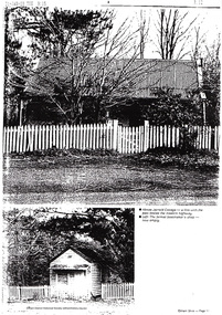
Document - Folder, Jarrold Cottage (White Cloud), 701 Main Road, Eltham, c.2002-c.2014
Information pertaining to the former Jarrold Cottage built in the early 1850s which has been in the Skipper family since 1944 Contents: 1 Journal Article: Jarrold Cottage; This quaint house survived fire and flood, Eltham Shire, newsletter c.2002, p10-11 2. Newspaper article: Cottage of 1800s, 100 Years of News Special Edition, (Leader Newspapers), August 27, 1997, p36 3. Jarrold Cottage (7), extract from tourist drive map publication (unknown) 4. Journal Article: Eltham . . . then and now, written by Judy Lewis, Eltham Town Community News, pp10-11, date unknown with hand written comments/corrections by Diana Bassett-Smith. Features Jarrold Cottage, Southernwood and Walter Withers and the former CBA Bank building. 5. Artice: Jarrold Cottage or White Cloud Cottage, compiled by Harry Gilham (2 pages)Folder of information on Jarrold Cottage consisting of 5 A4 photocopies and one A3 (colour) two page journalbootmakers cottage, cba bank, eltham, jarrold cottage, main road, southernwood, walter withers, white cloud cottage -
 Marysville & District Historical Society
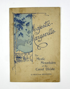
Booklet, Marysville Tourist Association, Magestic Marysville-The Mystic Mountains of the Great Divide, 1920's
An information guide of day trips to attractions in and around Marysville in Victoria. This booklet was produced by the Marysville Tourist Association.Paperback. Cover is beige with a drawing of two people standing next to a car looking at the view. The title is in dark blue across the front.non-fictionAn information guide of day trips to attractions in and around Marysville in Victoria. This booklet was produced by the Marysville Tourist Association.marysville, victoria, marysville tourise association, steavenson falls, keppel falls, cameron cascades, cumberland, mt cathedral, eildon, snob's creek falls, wolfram mine, mt strickland, keppel's lookout, mt kitchener, mt edgar, mt gordon, nichol's lookout, michael dene, beauty spot, gilbert's gully, taggerty river, wood's point -
 Marysville & District Historical Society
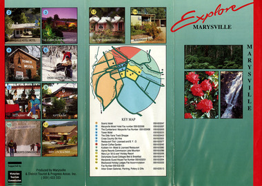
Ephemera (Item) - Information brochure, Marysville and District Tourist and Progress Association, Explore MARYSVILLE, Unknown
An information brochure with photographs and locations of various accommodation sites and businesses in Marysville as well as activities to experience in and around Marysville. This brochure was produced by the Marysville & District Tourist & Progress Association with the support of the Victorian Tourism Commission.An information brochure with photographs and locations of various accommodation sites and businesses in Marysville as well as activities to experience in and around Marysville.Supported by/ Victorian/ Tourism/ Commission Produced by Marysville/ & District Tourist & Progress Assoc. Inc.marysville, victoria, australia, information brochure, scenic motel, marysville motel hotel, the cumberland, tower motel, the olde yarra track shoppe, cross country ski hire, restaurant tirol, danish coffee garden, kufstein inn, lake mountain, mary-lyn resort, dalrymples guest cottages, marylands guest house, blackwood holiday lodges, abor green galleries, marysville & district tourist & progress association, victorian tourism commission -
 Marysville & District Historical Society
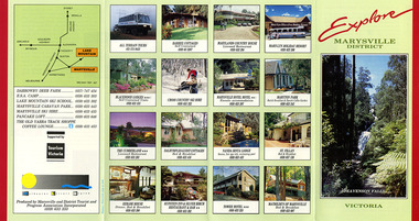
Ephemera (Item) - Information brochure, Marysville and District Tourist and Progress Association, Explore MARYSVILLE DISTRICT, Unknown
An information brochure with photographs of accommodation sites and businesses in Marysville as well as activities to experience in and around Marysville. This brochure was produced by the Marysville & District Tourist & Progress Association with the support of Tourism Victoria.An information brochure with photographs of accommodation sites and businesses in Marysville as well as activities to experience in and around Marysville.Supported by/ Victorian/ Tourism/ Commission Produced by Marysville/ and District Tourist and Progress Association Incorporatedmarysville, victoria, australia, information brochure, all terrain tours, baree cottages, marylands country house, may-yn holiday resort, blackwood lodges, cross country ski hire, marysville hotel motel, maryton park, the cumberland, dalrymples guest cottages, nanda binya lodge, st fillan, kerami house, kufstein inn, silver birch restaurant and bar, tower motel, mathilde's of marysville, steavenson falls, marysville and district tourist and progress association incorporated, tourism victoria, darrowby deer farm, esa camp, lake mountain ski school, marysville caravan park, marysville ski hire, pancake loft, the old yarra track shoppe -
 Marysville & District Historical Society
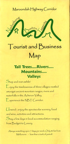
Map (Item) - Tourist and business map, Narbethong Community and Tourism Group, Narbethong Buxton Taggerty Tourist and Business Map, 04-2008
A tourist and business map of Narbethong, Buxton and Taggerty. This map was produced by the Narbethong Community and Tourism Group in April 2008. It was produced to promote the natural attractions, adventure activities and food trail from the Black Spur, through Narbethong, Buxton and Taggerty.A tourist and business map of Narbethong, Buxton and Taggerty.This publication has been produced by the Narbethong Community and Tourism/ Group (NCTG) to promote the natural attractions, adventure activities and food/ trail from the Black Spur, through Narbethong, Buxton and Taggerty./ the information provided in this publication has been supplied by the individual/ members. NCTG takes no responsibility for its accuracy./ April 2008narbethong, buxton, taggerty, victoria, australia, tourist and business map, narbethong community and tourism group, acheron valley, yarra track, wood's point, black spur, mystic mountains, the meeting of the waters, cathedral range, danico design counted cross stitch, things of sand & stone, buxton zoo nursery & oddz & enz, willowbank at taggerty, safe trek 4wd services, pnl 4wdriving, buxton trout and salmon farm, mystic mountains ski hire & outdoors, narbethong ski hire, highwood health centre, cathedral view natural therapies, narby cabinets, plants by shelian, gb timber, executive signs, rb automotive repairs, buxton car care, marysville towing & equipment hire, martyn slade building design, cathedral peak framing, black spur roadhouse & ski hire, tudor lodge roadhouse & ski hire, buxton roadhouse & persian bazzar, buxton post office general store & niche bar, igloo roadhouse, taggerty store, narby eggs, marapana agistment park, mantirri blueberry farm, carmyle farm, hazelwood hazelnuts, south cathedral lavender farm, cathedral cherries, black spur motel & caravan park, woodlands rainforest retreat, chestnut glade, black spur inn, wombat cottage, abbey lake luxury b & b spa cottages, blue views holiday cottages, camp narbethong, marapana farm stay b & b, mantirri blueberry farm b & b, little dene garden cottages, silverstream b & b cottages, nareen cabins, moondai farm b & b, south cathedral farm luxury b & b cottages, yarrolyn caravan park, sarsens rest, lomah retreat, pinjarra gardens, kingbilli country estate, henry viii manor house, buxton hotel, butters cafe of buxton, wagtail wines, little river wines, lanterns at willowbank, wirrawilla rainforest walk, wilhemina falls, the cascades -
 Marysville & District Historical Society
Map (Item) - Tourist and business map, Narbethong Community and Tourism Group, the Gateway TOURIST AND BUSINESS MAP, 08-2009
A tourist and business map of Narbethong, Buxton, and Taggerty. This map was produced by the Narbethong Community and Tourism Group Inc in August 2009. It was produced to promote the natural attractions, adventure activities, and food trail from the Black Spur, through Narbethong, Buxton, and Taggerty.A tourist and business map of Narbethong, Buxton and Taggerty.This publication has been produced by the Narbethong Community and Tourism Group Inc./ (NCTG) The information provided in this publication has been supplied by the individual/ members. NCTG takes no responsibility for its accuracy./ August 2009narbethong, buxton, taggerty, victoria, australia, tourist and business map, the gateway tourist and business map, black spur motel & caravan park, woodlands rainforest retreat, chestnut glade, black spur inn, wombat cottage, abbey lake luxury b&b spa cottages, camp narbethong, marapana farm stay b&b, mantirri b&b, little dene garden cottages, nareen cabins, silverstream b&b cottages, buxton hotel motel, south cathedral farm luxury b&b cottages, cathedral view b&b retreat, kingbilli country estate, cathedral valley farm, pinjarra gardens, willowbank at taggerty, sarsens rest, yarrolyn caravan park, danico design counted cross stitch, things of sand & stone, buxton zoo nursery, safetrek 4wd services, mystic mountains ski hire & outdoors, pnl 4wdriving, buxton trout and salmon farm, buxton bait and tackle, black spur roadhouse, tudor lodge service station roadhouse & ski hire, buxton roadhouse, buxton p.o. general store, igloo roadhouse, henry v111 manor house, buxton hotel, butters cafe, wagtail wines, little river wines, narby eggs, marapana agistment park, carmyle farm, hazelwood hazelnuts, cathedral view naturall therapies, cre8ing growth, linda hailey, naby cabinets, gb timber, narbethong timber & trading, rb automotive repairs, buxton car care, martyn slade building design, taggerty vet clinic -
 Greensborough Historical Society
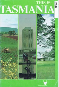
Booklet, Tasmanian Government Tourist Bureau, This is Tasmania, 1982
Information Booklet about Tasmania, written for the tourist.30 page Booklet with text and colour photostasmania, tourism -
Glenelg Shire Council Cultural Collection
Document - Portland and South West Tourist Guide, E. Davis & Sons, Pty Ltd Portland, n.d
Single page flyer, folded 3 times, printed both sides. White, black print, tourist guide to Portland and the far South West. Illustrations of Portland and district, maps of Portland, Heywood and Nelson, information about places to see. -
Glenelg Shire Council Cultural Collection
Pamphlet - Pamphlets - Portland and surrounds, Victoria, n.d
Collection of pamphlets, information and maps for seven tourist tours of Portland and district. a. green Tour No. 1 Town of Portland b. pale yellow Tour No.2 Portland Harbour c. blue Tour No. 3 Scenic Drive d. gold Tour No. 4 Cobboboonee Forest e. yellow Tour No.5 Nelson, Glenelg River and caves f. pink Tour No. 6 Bridgewater Bay, Lakes, Blowholes g. orange Tour No. 7 Yambuk Lakes, Mt. ClayFront: 'VIVIAN' -handwritten, blue biro, top right -
Glenelg Shire Council Cultural Collection
Booklet, Commissioned by Portland Tourist Association Inc, 'Portland Victoria's Birth Place Welcome to Living History', n.d
Bowerbird MuseumPromotional booklet for Portland and District. Heavy paper covers, green with coloured photos of Portland and district. 44 page booklet, white with black print. Map of Portland and District in centre. Book contains information on Portland, plus National Parks, reacreation, business advertisments. -
Glenelg Shire Council Cultural Collection
Pamphlet - Pamphlet - Western Wonderland Tourist Association, 1960s
Western Wonderland Tourist Association pamphlet. Contains tourism information for area bounded by Mt. Gambier, Casterton, Coleraine, Hamilton, Warrnambool, Pt Fairy and Portland.tourism, advertising -
 Halls Gap & Grampians Historical Society
Photograph - B/W, C 1918
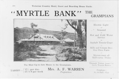
Information supplied with accommodation details Victorian Country Hotel, Guest and Boarding House Guide "Myrtle Bank" The Grampians Electric Light, Sewered, Hot and Cold Water Service, Asphalt, Tennis Court, Milk and Cream from our own farm, Motors meet all melbounre Trains, The Most Up-to-date house in the Grampians, Through Tickets issued by Govt. Tourist Bureau, Telephone : No. 1 Halls Gap Tariff: 12/ per day L 3/3/0 per week. Proprietress Mrs A. F WarrenGuest House and grounds with Tariff information and servicesQuality paper made in Germanyaccommodation, guesthouses, myrtlebank -
 Kiewa Valley Historical Society
Postcard Circa 1950, Lake Guy Dam and Bogong Village, Circa 1950
This postcard was produced in the 1950's for the tourist trade in the Kiewa Valley and Alpine region. It encompasses the period when the State of Victoria was pressured by the ever increasing demand by industry and its population for electricity supplies. Hydro electricity was seen as an untapped natural resource to quench this demand. The Victorian Alps and the rivers flowing into its valleys was ideal for the construction of the Kiewa Hydro Electricity Scheme. The late 1940's saw the development of this scheme and the changing of sections of alpine landscape is covered by this and other postcards/pictures (tourists, construction workers, and established rural populations). This period in time was before the established wildlife and forest/nature groups became political activist who changed legislative acts to protect the environment.This rural region (Kiewa Valley/alpine plains) was at most only significant to a smaller group of winter sports, summer hikers/horse riders and rural farmers/graziers. The numbers of tourists and the increase in the local resident population was boosted by the construction of the Hydro Electricity Scheme. This influx to the regional population resulted in a corresponding diversity in services and brought about an environment that responded to a growing level of tourists and thereby permitting this industry to grow more rapidly than it would have naturally. This postcard details an attraction to the "cleaner" method of providing electricity. This postcard was purchased in 1950 by a surveyor at Landford's Gap.This black and white photograph from a Valentine's postcard is from a V2 Argus photograph postcard. It is on a 200g/m paper density photo side gloss. See 0480 (B) - (F) for other photos of similar postcards.In white lettering " LAKE GUY & BOGONG VILLAGE KIEWA HYDRO-ELECTRIC PROJECT"kiewa valley tourism, victorian alps, alternate energy supplies, alpine population growth -
 Kiewa Valley Historical Society
Postcard Circa 1950, Snowfall at Bogong Village Kiewa Hydro-Electric Project, 1950s
This postcard was produced in the 1950's for the tourist trade in the Kiewa Valley and Alpine region. It encompasses the period when the State of Victoria was pressured by the ever increasing demand by industry and its population for electricity supplies. Hydro electricity was seen as an untapped natural resource to quench this demand. The Victorian Alps and the rivers flowing into its valleys was ideal for the construction of the Kiewa Hydro Electricity Scheme. The late 1940's saw the development of this scheme and the changing of sections of alpine landscape is covered by this and other postcards/pictures (tourists, construction workers, and established rural populations). This period in time was before the established wildlife and forest/nature groups became political activist who changed legislative acts to protect the environment.This rural region (Kiewa Valley/alpine plains) was at most only significant to a smaller group of winter sports, summer hikers/horse riders and rural farmers/graziers. The numbers of tourists and the increase in the local resident population was boosted by the construction of the Hydro Electricity Scheme. This influx to the regional population resulted in a corresponding diversity in services and brought about an environment that responded to a growing level of tourists and thereby permitting this industry to grow more rapidly than it would have naturally. This postcard details an attraction to the "cleaner" method of providing electricity. This postcard was purchased in 1950 by a surveyor at Landford's Gap.This scanned black and white photograph of a postcard, shows vehicles covered in thick snow at Bogong Village in 1950. See 0480(A), (C) - (F) for other similar photos of postcards available at this period."SNOWFALL AT BOGONG VILLAGE KIEWA HYDRO-ELECTRICITY PROJECT"kiewa valley tourism, victorian alps, alternate energy supplies, alpine population growth, bogong village, secv -
 Kiewa Valley Historical Society
Postcard Circa 1950, Scene in Bogong Village Kiewa Hydro-Electric Project, 1950s
This postcard was produced in the 1950's for the tourist trade in the Kiewa Valley and Alpine region. It encompasses the period when the State of Victoria was pressured by the ever increasing demand by industry and its population for electricity supplies. Hydro electricity was seen as an untapped natural resource to quench this demand. The Victorian Alps and the rivers flowing into its valleys was ideal for the construction of the Kiewa Hydro Electricity Scheme. The late 1940's saw the development of this scheme and the changing of sections of alpine landscape is covered by this and other postcards/pictures (tourists, construction workers, and established rural populations). This period in time was before the established wildlife and forest/nature groups became political activist who changed legislative acts to protect the environment. This rural region (Kiewa Valley/alpine plains) was at most only significant to a smaller group of winter sports, summer hikers/horse riders and rural farmers/graziers. The numbers of tourists and the increase in the local resident population was boosted by the construction of the Hydro Electricity Scheme. This influx to the regional population resulted in a corresponding diversity in services and brought about an environment that responded to a growing level of tourists and thereby permitting this industry to grow more rapidly than it would have naturally. This postcard details an attraction to the "cleaner" method of providing electricity. This postcard was purchased in 1950 by a surveyor at Landford's Gap. The couple shown in this photograph would have been employed by the S.E.C. under the Kiewa Hydro-Electricity Scheme.This item is a scanned black and white photograph of a couple walking along a gravel street in Bogong Village in 1950. See 0480 (A) ,(B), (D) - (F) for other photos of similar postcards" SCENE IN BOGONG VILLAGE KIEWA HYDRO-ELECTRIC PROJECT"kiewa valley tourism, victorian alps, alternate energy supplies, alpine population growth, bogong, secv -
 Kiewa Valley Historical Society
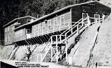
Postcard Circa 1950, Men's Mess No.4 Power Station, Kiewa Hydro-Electric Project
This postcard was produced in the 1950's for the tourist trade in the Kiewa Valley and Alpine region. It encompasses the period when the State of Victoria was pressured by the ever increasing demand by industry and its population for electricity supplies. Hydro electricity was seen as an untapped natural resource to quench this demand. The Victorian Alps and the rivers flowing into its valleys was ideal for the construction of the Kiewa Hydro Electricity Scheme. The late 1940's saw the development of this scheme and the changing of sections of alpine landscape is covered by this and other postcards/pictures (tourists, construction workers, and established rural populations). This period in time was before the established wildlife and forest/nature groups became political activist who changed legislative acts to protect the environment.Although this photo details the eating facilities of the construction workers at the power station it was not only a postcard for the people employed in the Hydro Scheme is was also provided to tourists visiting the area and thus used for promotional purposes.This rural region (Kiewa Valley/alpine plains) was at most only significant to a smaller group of winter sports, summer hikers/horse riders and rural farmers/graziers. The numbers of tourists and the increase in the local resident population was boosted by the construction of the Hydro Electricity Scheme. This influx to the regional population resulted in a corresponding diversity in services and brought about an environment that responded to a growing level of tourists and thereby permitting this industry to grow more rapidly than it would have naturally. This postcard details an attraction to the "cleaner" method of providing electricity. This postcard was purchased in 1950 by a surveyor at Landford's Gap. The men shown in this photograph would have been employed by the S.E.C. under the Kiewa Hydro-Electricity Scheme.This item is a scanned black and white photograph of a construction worker walking from stairs leading down from the men's mess building, in 1950. See 0480 (A) -(C), (E) - (F) for other photos of similar postcards"MEN'S MESS No.4 POWER STATION AREA, KIEWA HYDRO-ELECTRIC PROJECT" "ARGUS PHOTO V.IIkiewa valley tourism, victorian alps, alternate energy supplies, alpine population growth, secv -
 Kiewa Valley Historical Society
Postcard Circa 1950, Mt. Beauty Village, Kiewa Hydro-Electricity Project, circa 1950
This postcard was produced in the 1950's for the tourist trade in the Kiewa Valley and Alpine region. It encompasses the period when the State of Victoria was pressured by the ever increasing demand by industry and its population for electricity supplies. Hydro electricity was seen as an untapped natural resource to quench this demand. The Victorian Alps and the rivers flowing into its valleys was ideal for the construction of the Kiewa Hydro Electricity Scheme. The late 1940's saw the development of this scheme and the changing of sections of alpine landscape is covered by this and other postcards/pictures (tourists, construction workers, and established rural populations). This period in time was before the established wildlife and forest/nature groups became political activist who changed legislative acts to protect the environment. The regulatory pondage on the northern aspect of the village had no water over-spill from the unfinished power station.This rural region in 1950 (Kiewa Valley/alpine plains) was at most only significant to a smaller group of winter sports, summer hikers/horse riders and rural farmers/graziers. The numbers of tourists and the increase in the local resident population was boosted by the construction of the Hydro Electricity Scheme. This influx to the regional population resulted in a corresponding diversity in services and brought about an environment that responded to a growing level of tourists and thereby permitting this industry to grow more rapidly than it would have naturally. This postcard details an attraction to the "cleaner" method of providing electricity. This postcard was purchased in 1950 by a surveyor at Landford's Gap. The couple shown in this photograph would have been employed by the S.E.C. under the Kiewa Hydro-Electricity Scheme.This item is a scanned black and white photograph of a panoramic view of Mount Beauty Village in 1950 (a closed village, entry by pass only). The regulatory pondage has earthen walls but no water.See 0480 (A) -(D) and (F) for other photos of similar postcards"MT. BEAUTY VILLAGE KIEWA HYDRO-ELECTRIC PROJECT"kiewa valley tourism, victorian alps, alternate energy supplies, alpine population growth -
 Kiewa Valley Historical Society
Postcard Circa 1950, Howman Gap Hostel under snow Kiewa Hydro-Electric Project, Circa 1950
This postcard was produced in the 1950's for the tourist trade in the Kiewa Valley and Alpine region. It encompasses the period when the State of Victoria was pressured by the ever increasing demand by industry and its population for electricity supplies. Hydro electricity was seen as an untapped natural resource to quench this demand. The Victorian Alps and the rivers flowing into its valleys was ideal for the construction of the Kiewa Hydro Electricity Scheme. The late 1940's saw the development of this scheme and the changing of sections of alpine landscape is covered by this and other postcards/pictures (tourists, construction workers, and established rural populations). This period in time was before the established wildlife and forest/nature groups became political activist who changed legislative acts to protect the environment.This rural region (Kiewa Valley/alpine plains) was at most only significant to a smaller group of winter sports, summer hikers/horse riders and rural farmers/graziers. The numbers of tourists and the increase in the local resident population was boosted by the construction of the Hydro Electricity Scheme. This influx to the regional population resulted in a corresponding diversity in services and brought about an environment that responded to a growing level of tourists and thereby permitting this industry to grow more rapidly than it would have naturally. This postcard details an attraction to the "cleaner" method of providing electricity. This postcard was purchased in 1950 by a surveyor at Landford's Gap.This item is a scanned black and white photograph of a panoramic view of Howman Gap Hostel under snow in 1950 (a closed village, entry by pass only). This accommodation was for construction workers only. See 0480 (A) -(E) for other photos of similar postcards.On the photo, " Howman Gap Hostel under snow Kiewa Hydro-Electric Project" . On postcard address and personal information side "V.2 Valentine's Post Card "kiewa valley tourism, victorian alps, alternate energy supplies, alpine population growth, bogong, secv, howman's gap hostel -
 Kiewa Valley Historical Society
Photograph of Kiewa Valley Panorama, Farming lands within the Kiewa Valley in1950s, Circa 1950
This photograph shows how (early to mid1900s), before the establishment of the Mount Beauty "gated" village, the Kiewa Valley was farmed and the scarce population was spread out over acres of productive land. This photograph catches a time before (what appeared to the local farmers as the invasion by a mass of construction workers) when this remote valley was part of a "lay back" rural landscape,occasionally visited by friends and some wayward tourists. The mountain ranges provided an adequate barrier against the way-would traveller. The immigration numbers coming into Australia was still quite small ( due to the "white" Australia policy) which was in force before World War II. After World War II a mass of displaced European refugees and migrants boosted the Australian population and provided for a greater degree of diverse professions and rural related work force.This photograph depicts the borderline in time between an exclusively rural based population and respective activities(early 1900s)to the present (2000 on wards) integrated village, tourist and retiree/holiday area. The time when land was exclusively used in agriculture is over and the impact of cheaper rural produce from Asian markets will see a shift of land useage and population activities. The Kiewa Valley is loosing its hiding place and is becoming more and more a source of untapped residential land. Black and white photograph of farming/grazing land useage, before the establishment of the Mount Beauty Village. Small pockets of residentual houses can be viewed. Road access (unsealed dirt) was typical of that provided in rural regions in the 1950s. The photo is on 200gms paper and not on photographic paper.kiewa valley in the early1900s, grazing in the kiewa valley, sec victoria