Showing 1580 items
matching city of moorabbin
-
 City of Kingston
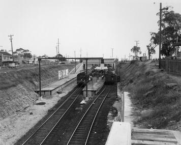
Photograph - Black and white, Public Transport Corporation, c. 1959
... City of Kingston Parkdale Library 96 Parkers Road, Parkdale ...Black and white photograph of Moorabbin railway station, at the completion of works to relocate it to below street level. There are two "red rattler" trains pulled in to the station, utilising each of its two tracks and two of its three platforms. A third platform is visible to the left of the image, but no tracks have been laid to allow for an additional train. This image is part of a larger collection of images from the Public Transport Corporation displaying train stations and streetscapes in what is now the City of Kingston.Black and white photograph of Moorabbin railway station, at the completion of works to relocate it to below street level. There are two "red rattler" trains pulled in to the station, utilising each of its two tracks and two of its three platforms. A third platform is visible to the left of the image, but no tracks have been laid to allow for an additional train. Stamped in blue ink on reverse: COPYRIGHT / Public Transport Corporation / For re-ordering photographs / Please quote negative No M6859 / Enquiries C/- PTC Photographic Unit / Telephone switchboard 619 111moorabbin, railway station, red rattler, public transport -
 City of Kingston
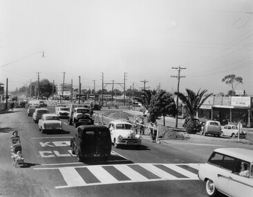
Photograph - Black and white, c. 1957
Copy black and white photograph of railway level crossing on Nepean Highway Moorabbin before excavations for the below ground rail crossing. The level crossing gates are closed and five cars are waiting, while other cars can be seen coming in the opposite direction. A woman with a child in a pram is walking along the road, and a number of men, probably construction workers, are standing behind a barricade on the right hand side of the road. Gilbey's Gin distillery is visible in the background. TCopy black and white photograph of railway level crossing on Nepean Highway Moorabbin before excavations for the below ground rail crossing. The level crossing gates are closed and five cars are waiting, while other cars can be seen coming in the opposite direction. A woman with a child in a pram is walking along the road, and a number of men, probably construction workers, are standing behind a barricade on the right hand side of the road. Gilbey's Gin distillery is visible in the background. Handwritten in blue ink on reverse: 57-465C Handwritten in red ink on reverse: 71% A red circle has been drawn around all handwritten text.moorabbin, railway station, railway crossing, suburbs, cars, local production -
 City of Kingston
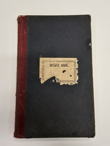
Book - Minute book, Minute book of the Cheltenham Rifle Club, 1900
At a well attended meeting at the Mechanics Hall in Cheltenham in March 1900, attendees decided to form a rifle club. The newly appointed secretary of the newly formed Cheltenham Rifle Club, Mr E.C. Rippon, enrolled 55 new members on the day, and the club resolved to consult with the Defence Department regarding the suitability of Cheltenham Park for that purpose, and Moorabbin Council to grant the use of the park. By 1912 the club was already on the verge of disintegrating. The Cheltenham Park range had been disbanded two years earlier. A new, shorter range and club rooms were completed in October 1912. The club continued to have difficulties over location and funds, despite being granted an exemption from paying rates for the duration of the First World War. In 1919, a proposal to disband was put forward at a club meeting. Members rejected the proposal deciding instead to wait on the rumoured reopening of the Langwarrin range. By 1921 it became evident the Langwarrin range would not reopen. A resolution to wind up the organisation was put to the meeting and accepted.Green, cloth bound book with red leather spine. A white label is adhered to the front of the book with MINUTE BOOK printed in black text. The book is hardcovered and, inside, are approximately 186 pages which have been filled with handwritten text as meeting minutes and lists, including a list of commitee officers. The inside fly pages are decorated with blue and red marbling.Handwritten text on the white paper adhered to the front of the book is no longer legible.cheltenham, sport, club, rifles -
 City of Kingston
Photograph - Black and white, c. 1970
This photograph depicts the steel tramway (or tram plate) along Centre Dandenong Road, Cheltenham near the Moorabbin Airport entrance in the 1970's. These tramways played an important role in transportation along Moorabbin's major roads. Heavily laden carts could travel smoothly and safely along the steel plates when the road surfaces were often rutted and hazardous. This surviving section was later moved for road improvements. The area now known as the City of Kingston was a market garden region and the round trip to market could take as long as eight hours on poorly maintained roads. The installation of the steel tramway transformed the arduous journey faced by market gardeners in transporting their produce to market. As there was only a single tramway, the carts often travelled in convoy, enabling drivers to leave piloting to the first cart and having a rest. The rails did not speed the journey to the city, but it smoothed progress immeasurably. Black and white photograph of steel tram plates on Centre Dandenong Road, Cheltenham. The road is sealed. At the top of the image there are trees behind a parked car which is adjacent to a white shelter. There is a large sign stating MOORABBIN AIRPORT above an arrow pointing to the right in the top centre of the image. Handwritten in pencil: A 28 / [indecipherable] 3 / [indecipherable] Handwritten in red ink: A28 / 70%market gardening, infrastructure, transport, steel tramway, industry, moorabbin -
 City of Kingston
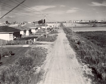
Photograph - Black and white, c. 1960
... , formally City of Moorabbin. This image illustrates the mid century ...This image depicts a scene of East Bentleigh in 1960, viewed along Thomasina Street as it crosses Gladwyn Street towards East Boundary Road in the distance. The gardens and new homes are well-tended, but the street surfacing is unsealed.Developing urban area now located within the City of Glen Eira, formally City of Moorabbin. This image illustrates the mid century urban sprawl of new suburbs and the subdivision of market gardens within the municipality and the changing demographic of the district as new houses are constructed and infrastructure established. Black and white photograph of unsealed road in new development in the area of Moorabbin, new houses appear on the lefthand side with paddocks on right side of image with installation of electric poles. Sealed road in the distance. Thomasina Street, as it crosses Gladwyn Street, East Bentleigh towards East Boundary Road. Handwritten in blue ink: 60 - 373 D Handwritten in red ink: 80% Handwritten in black ink: Ch. 6bentleigh, east bentleigh, market garden, housing, suburbs, infrastructure, moorabbin -
 City of Kingston
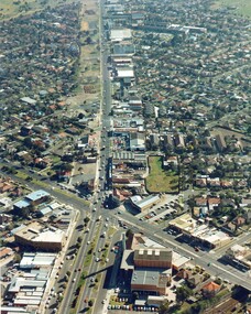
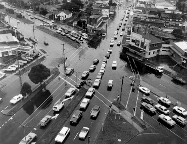
Photograph - Colour, c. 1982
This aerial photograph of South Road and Nepean Highway, Moorabbin shows the area where houses and shops on the south side of the Nepean Highway have demolished for the widening of the highway. The pressures of rapid urban development in Moorabbin and beyond, especially to the south of Moorabbin caused bottlenecks and delays, especially at the South Road and Nepean Highway intersection, hence the scheme to widen Nepean Highway.The pressures of rapid urban development in terms of people, housing construction, industrial development and commercial activity, in Moorabbin and beyond, especially to the south would put pressure on road infrastructure in the region. In the early 1980s, a major road expansion of the Nepean Highway was implemented to increase capacity on this major thoroughfare for vehicle commuters. Car use had also increased with commuters from the increasingly populous southern suburbs travelling to their place of work in the Melbourne CBD.Colour photograph of an aerial view of South Road and Nepean Highway, Moorabbin. The image shows houses on the south side of the Nepean Highway that have demolished for widening of road. It features housing and commercial buildings looking north towards Cummins Road.Handwritten blue ink: 82 - 5452 - 11 Handwritten red ink: 112% Handwritten black ink: Ch. 7nepean highway, south road, moorabbin, roads, transport, infrastructure -
 City of Kingston
Photograph - Black and white, c. 1956
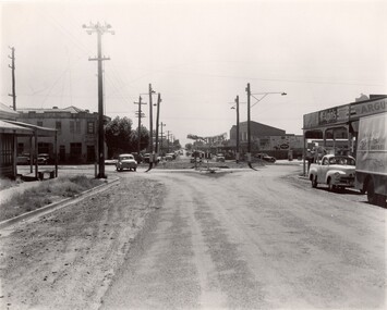
Strip shopping and ample parking were features of suburbs in the middle of the twentieth centuries. Cars were still considered a luxury, although that would soon change, and local, independent shops serviced local areas.During the post-war years, the municipality of Moorabbin experienced a population boom. The 'newcomers' were predominantly returnees from the war who were marrying and establishing families; those from the old inner-suburban areas who were moving away from rented premises to establish their own homes on cheap land. The 1950s were a time of immense growth for the area now known as City of Kingston.Black and white photograph of the intersection of Centre and East Boundary roads, Bentleigh East. Several cars are visible both in the foreground and background, and the intersection includes a roundabout. The street is lined with poles to carry electricity cables, and the roundabout is dotted with four poles for electric street lights.Handwritten in blue ink: 56 - 230 Handwritten in red ink: 82% Handwritten in black ink: Ch. 6shopping strip, cars, suburbs -
 City of Kingston
Photograph - Black and white, 1962
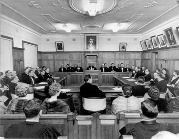
... councils across Victoria were amalgamated and the City of Moorabbin ...Local government for Moorabbin began in 1862 when the area was separated from Brighton with the creation of the Moorabbin Roads Board. This meeting commemorated the centenary of local government in 1962.1862 saw the beginnings of local government in the Moorabbin district when the area was separated from Brighton with the creation of the Moorabbin Roads Board. Moorabbin was declared a shire in 1871 and a city in 1934. While tinkering with boundaries occurred over time, the first major severance from Moorabbin was when the Borough of Sandringham was created in 1917. Three years later, after persistent agitation, on May 27, 1920 Mordialloc, Parkdale and Mentone became part of the new Borough of Mordialloc. With this change the Shire of Moorabbin no longer had authority for land with a frontage to Port Phillip Bay. In 1994 councils across Victoria were amalgamated and the City of Moorabbin was divided between the cities of Kingston and Glen Eira. The City of Kingston is made up the former cities of Chelsea, Mordialloc, Moorabbin, Oakleigh and Springvale.Black and white image of inside of Moorabbin Council Chambers, with a meeting (possibly staged) in progress. Council members are seated behind a bench which connects to a horseshoe shaped table. All in attendance are in formal attire. Men are wearing black tie and the women in the audience (with backs to camera) are wearing fur coats or stoles.Black printed text of white round sticker adhered to reverse: 191 Handwritten in red ink: 80%moorabbin, council, chambers, council meeting, centenary -
 City of Kingston
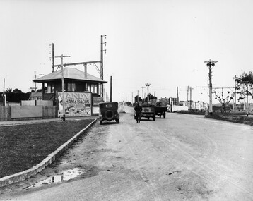
Photograph - Black and white, c. 1930
This image is part of a larger collection of images from the Public Transport Corporation displaying train stations and streetscapes in what is now the City of Kingston.The Nepean Highway is a major highway running through the City of Kingston. This image is one of many that depicts its importance to the local community as it undergoes many changes over time.Black and white photograph depicting the level crossing at Moorabbin. While the gates at the level crossing are open, two cars are making their way across the crossing, while a third car is parked on the side of the road, in front of a large billboard/hoarding for ham and bacon products. There is a man standing on the road as if watching the cars go through the crossing. The road appears to be unsealed. Black printed text on a round white sticker adhered to the reverse: 148 Handwritten in red ink: 60% Blue ink stamped on reverse: COPYRIGHT / Public Transport Corporation / For re-ordering photographs / Please quote negative No ADU907 / Enquiries C/- PTC Photographic Unit / Telephone switchboard 619 111moorabbin, trains, railway crossing, level crossing, cars, roads, nepean highway -
 City of Kingston
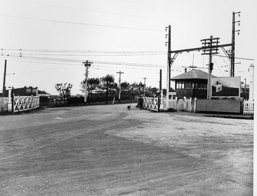
Photograph - Black and white, c. 1930
This image is part of a larger collection of images from the Public Transport Corporation displaying train stations and streetscapes in what is now the City of Kingston.The Nepean Highway is a major highway running through the City of Kingston. This image is one of many that depicts its importance to the local community as it undergoes many changes over time.Black and white photograph depicting railway crossing at Nepean Highway Moorabbin. The level crossing gates are open and a man is walking through with his dog. To the right of the crossing is a billboard/hoarding promoting what appears to be a brand of radio/wireless.White round sticker with indecipherable black printed text which has been scribbled over with black pen. White round sticker with black printed text: 175 Handwritten in red ink: 50% Blue ink stamped on reverse: COPYRIGHT / Public Transport Corporation / For re-ordering photographs / Please quote negative No ADV 903 / Enquiries C/- PTC Photographic Unit / Telephone switchboard 619 111moorabbin, trains, railway crossing, level crossing, nepean highway -
 City of Kingston
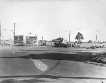
Photograph - Black and white, c. 1930
This image is part of a larger collection of images from the Public Transport Corporation displaying train stations and streetscapes in what is now the City of Kingston.The Nepean Highway is a major highway running through the City of Kingston. This image is one of many that depicts its importance to the local community as it undergoes many changes over time.Black and white photograph of the level crossing at Neapean Highway Moorabbin. Photograph is a slightly side view, with a blurred image of a car approaching the level crossing. The gates are closed. To the left of the image is a pair of billboards. The billboard on the left is promoting Creamoata, a New Zealand brand of oats, and the billboard on the right is promoting Kraft cheese.White round sticker on reverse with black printed text: 147 Handwritten in red ink on reverse: 100% Blue ink stamped on reverse: COPYRIGHT / Public Transport Corporation / For re-ordering photographs / Please quote negative No ADV 1030 / Enquiries C/- PTC Photographic Unit / Telephone switchboard 619 111moorabbin, level crossing, railway crossing, cars, advertising, nepean highway -
 City of Kingston
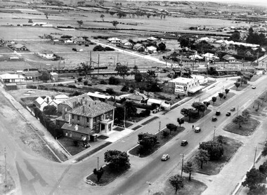
Photograph - Black and white, c. 1930
During the 1930s Moorabbin was an area with open grasslands, still often used for market gardening. The development of the city (and, later, suburb) can be seen emerging from the railway station.The Nepean Highway is a major highway running through the City of Kingston. This image is one of many that depicts its importance to the local community as it undergoes many changes over time.Black and white photograph of aerial view of intersection of Nepean Highway and South Road. Moorabbin Council Chambers are situated on the corner with the library, old shire building, Moorabbin railway station, St David's Anglican Church market gardens and open paddocks in the background.White round sticker on reverse with black printed text: 143 Handwritten in red ink on reverse: 156% / k000786moorabbin, council, railway station, railway, suburbs, paddocks, nepean highway -
 City of Kingston
Photograph - Black and white, c. 1950
The image shows a line of traffic travelling along South Road in response to traffic light signlas while an increasing number of cars are banking up along Nepean Highway, also in response to traffic light signals.This image provides a strong contrast to images from earlier eras of the same intersection. The amount of traffic has increased enormously as well as commercial development.Black and white photograph with an aerial view of the intersection of Nepean Highway and South Road, taken from above the Moorabbin Council Chambers.Handwritten in black ink Pic [indecipherable] / 1000 Handwritten in red ink: 150%moorabbin, traffic lights, cars, nepean highway -
 City of Kingston
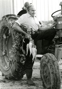
Photograph - Black and white, Moorabbin News, 1963
... . Everest, his son, was a councillor for the City of Moorabbin ...Francis (Frank) Wilbur Le Page was mayor of Moorabbin between 1980 - 1981, and again in 1984 - 1985. He was a lifelong resident of the region and also a third generation market gardener.In approximately 1854, Nicholas Le Page moved his family from Prahran to Cheltenham. Two years earlier, they had arrived in Melbourne from Guernsey Island. Nicholas Le Page was a tailor and his wife was a dressmaker. They decided to move into market gardening instead. Their son, Everest, married Lynda and Francis Wilbur Le Page was born in 1919. He attended Cheltenham State School where he completed his Merit Certificate in grade eight before studying bookkeeping, shorthand and typing at Bradshaw and Everett Business College in South Melbourne. Both Frank’s grandfather and father were active in local government. Francis Thomas Le Page was a councillor for 25 years and served a term as shire president in 1902. Everest, his son, was a councillor for the City of Moorabbin for 28 years and was mayor on two occasions. Frank also served two terms as mayor, first in 1980 and again in 1984. Frank died on 14 July 2008.Black and white photograph of Frank Le Page stepping down from a tractor, with a bunch of parsnips in his right hand.Pink coloured paper adhered to reverse with black printed text and handwritten text in blue ink: STANDARD NEWS / Paper MOOR / Catchline Garden / Percentage 88% / Date 17-10-84 / Page 23le page, market gardens, tractor, moorabbin -
 City of Kingston
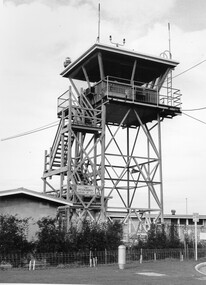
Photograph - Black and white, c. 1970
Moorabbin Airport was acquired in 1946 by a group of aviators and the Civil Aviation Department, Moorabbin Airport opened as a fully-functioning aerodrome in December 1949, chosen for its ideal location in the Market Gardens for an aviation base to be situated southeast of Melbourne. Black and white photograph of the control tower at Moorabbin Airport. At the base of the tower is a single storey brick building with a wire fence at the running across the front.Handwritten in black ink on reverse: 701 Handwritten in red ink on reverse: 100%moorabbin, airport, aviation -
 City of Kingston
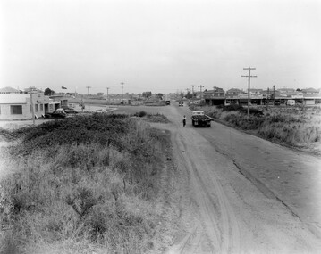
Photograph - Black and white, c. 1957
This image shows the urbanisation of a formerly rural area of Moorabbin.Black and white photograph looking west along South Road. There is a truck in the foreground, travelling along the sealed South Road. A car is waiting to exit from Rowan Road. People are walking along the left hand side of the road, and a young person a bike is riding along the right side. They are all going in the same direction as the traffic. The left hand side of the image shows paddocks in the foreground, which houses further back. The right hand side of the image shows suburban houses with electricity poles running the length of the road. Handwritten in blue ink on reverse: 57-523A Handwritten in red ink on reverse: 85% Handwritten in black ink or grey lead: Ch. 6moorabbin, cars, roads, housing -
 City of Kingston
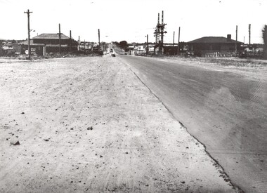
Photograph - Black and white, 1957
This image shows the increasing urbanisation of the formerly rural area of Moorabbin.Black and white photograph of the intersection of South Road and Chesterville Road, Moorabbin. A service station is visible on the left hand side, a truck is travelling along the road and shops are under construction on the right hand side.Handwritten in blue ink on reverse: 57-523B Handwritten in red ink on reverse: 100%moorabbin, shopping strip, paddocks, roads, cars -
 City of Kingston
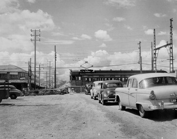
Photograph - Black and white, c. 1957
This image depicts the increasing urbanisation of Moorabbin. While there are several cars in line waiting for the train to go through the crossing and the gates to open, in the distance there is a lot of activity on the road, with many cars.Black and white photograph depicting the railway crossing at South Road, Moorabbin. There is a 'Red Rattler' passenger train going through the level crossing travelling towards the city.Handwritten in blue ink on reverse: 57-4078 Handwritten in red ink on reverse: 82% Handwritten in black ink on reverse: Ch. 6moorabbin, trains, cars, urbanisation, suburbs -
 City of Kingston
Photograph - Black and white, c. 1950
This image shows a sealed road running along South Road, although with a wide gravel shoulder. The railway crossing gates were hand operated. This image is one of many in the collections that focuses on the railway. The development of the railway was crucial to the ongoing development of the area. Community life often sprang up along and beside the railway.Black and white photograph of the railway crossing at South Road, Moorabbin, viewed from Nepean Highway. Handwritten in blue ink on reverse: 217 Handwritten in red ink on reverse: 80%moorabbin, railway, railway crossing -
 City of Kingston
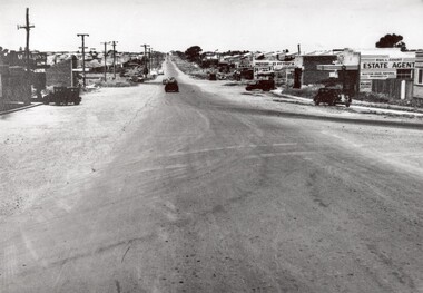
Photograph - Black and white, 1950
This photograph depicts the increasing urbanisation of a once rural area at Moorabbin.This image is one of many in the collections that focuses on either roads or the railway. The development of roads and the railway was crucial to the ongoing development of the area. Black and white photograph of South Road, Moorabbin, with Station Street to the right and Jasper Road further down to the left. Along both sides of the road are retail spaces which become homes on the left hand side, after Jasper Road.Handwritten in red ink on reverse: 80% Handwritten in blue ink on reverse: 216moorabbin, roads, cars, shopping strip, housing -
 City of Kingston
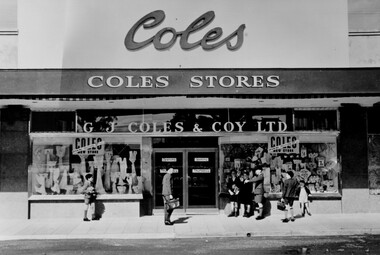
Photograph - Black and white, 1949
The Coles store in Moorabbin opened in 1949.Black and white photograph depicting the as yet unopened Coles store in Moorabbin with a group of boys standing around the front. The boys don't appear to be taking any particular interest in the store but the photograph provides an excellent view of the facade of the store.Handwritten in blue ink on white sticker on reverse: COLES MOORABBIN / 1949 Printed black text on white sticker on reverse: 203 Handrwitten in red ink on reverse: 70%shopping, consumerism, suburbs -
 City of Kingston
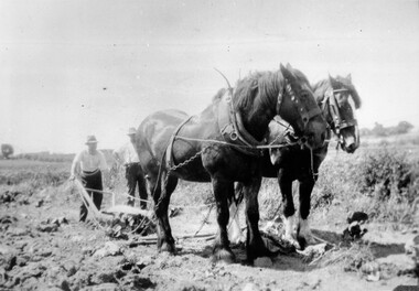
Photograph - Black and white, c. 1920
Horses were frequently used to assist in the manual labour of farming right up to the mid twentieth century. This image was taken while ploughing market garden fields in Moorabbin.Black and white image of two Clydesdale horses attached to harness and pulling a plough. Two men are behind the horses, one is holding the handles of the plough and the other is standing next to him with his hands on his hips.Handwritten in red ink on reverse: 70% Printed in black text on white round sticker adhered to reverse: 41horses, manual labour, farming, moorabbin -
 City of Kingston
Photograph - Black and white, 5 January 1984
Cheltenham and Heatherton are suburbs in the City of Kingston that were originally established as a rural market gardening community. The market gardens, farms and paddocks have gradually been sub-divided into housing and industrial estates and associated infrastructure such as schools and shopping facilities. This aerial image covers a diverse section of the City of Kingston, taking in the suburbs of Cheltenham, Heatherton, Mentone and Parkdale. By 1984, the market gardens of the district have been replaced by housing and factories. The Nylex factory is visible and now closed. Mentone Bowl on the corner of Warrigal Road and Nepean Highway has now been replaced by high rise apartments, another feature of the changing landscape in the City of Kingston. The vacant land now occupied by the Moorabbin Airport Direct factory Outlet (DFO) is also depicted.Aerial photograph of Cheltenham, Heatherton, Mentone and Parkdale within the City of Kingston. The area depicted in the 1984 aerial view includes Centre Dandenong Road and Cheltenham East Primary School (top left), Kingston Heath Reserve (top right), intersection of Lower Dandenong Road, Warrigal Road, Balcombe Road and Nepean Highway (bottom left), Balmoral Drive/McSwain Street Parkdale (bottom right).White text: 3831-179 Lens information [indecipherable] RINGWOOD M/S 7922-3 RUN 16 [Clockface image] 5,300' ASL VIC DLS© 5-1-84cheltenham, heatherton, mentone, parkdale, market gardens, urbanisation -
City of Kingston
Photograph - Black and white, 5 January 1984
... Aerial photograph of Cheltenham, Beaumaris, Moorabbin... Parkdale Moorabbin, Cheltenham and Highett are suburbs in the City ...Moorabbin, Cheltenham and Highett are suburbs in the City of Kingston with a diverse mix of development and zoning. The market gardens, farms and paddocks have gradually been sub-divided into housing and industrial estates and associated infrastructure such as schools and shopping facilities. The area includes many parks, reserves and golf courses.This aerial image covers a diverse section of the City of Kingston, taking in the suburbs of Cheltenham, Moorabbin, Beaumaris and Highett. By 1984, the market gardens of the district have been replaced by housing and factories. The Gas and Fuel state-of-the-art Scientific Services Department is visible on Nepean Highway Highett. The CSIRO Highett site can also be seen. Both sites have now been demolished and have undergone remediation. The Southland site is visible and yet to be redeveloped by Westfield. This image portrays the diversity of development in the City of Kingston with a mixture of green spaces, housing and commercial and industrial features.Aerial photograph of Cheltenham, Beaumaris, Moorabbin and Highett within the City of Kingston. The area depicted in the 1984 aerial view includes Eden Street and Edward Street, Cheltenham (top left), Weatherall Road and Reserve Road, Cheltenham/Beaumaris (top right), Turner Road and Chesterville Road, Moorabbin (bottom left), Nepean Highway (left section), Graham Road and Middleton Street, Highett (bottom right). A large section of this image includes Cheltenham Park and Victoria Golf Club.White text: 3831-219 Lens information [indecipherable] RINGWOOD M/S 7922-3 RUN 15 Clockface image 5,300' ASL VIC DLS© 5-1-84cheltenham, highett, industrialisation, urbanisation, moorabbin, beaumaris -
City of Kingston
Photograph - Black and white, 17 January 1951
... Aerial photograph of Cheltenham, Moorabbin and Highett... Parkdale Moorabbin, Cheltenham and Highett are suburbs in the City ...Moorabbin, Cheltenham and Highett are suburbs in the City of Kingston with a diverse mix of development and zoning. This 1954 image shows the market gardens, farms and paddocks of the Moorabbin and Cheltenham area. which have gradually been sub-divided into The Highett Gas Works is visible and Cheltenham Park and Victoria Golf Club.The suburbs of Cheltenham and Moorabbin were originally developed with extensive market gardens. Over time the district has been transformed with the farms and paddocks replaced by housing, factories and shopping centres. The Highett Gas Works on the Nepean Highway was a significant feature of the landscape and has now been demolished. and the site has undergone remediation.Aerial photograph of Cheltenham, Moorabbin and Highett within the City of Kingston. The area depicted in this 1951 aerial view includes Wickham Road, Highett (bottom right), Keys Road, Moorabbin (bottom left), Centre Dandenong Road Cheltenham (top left), Park Road, Cheltenham (top right), Nepean Highway (left section), Graham Road and Middleton Street, Highett (bottom right). Cheltenham Park and Victoria Golf Club are visible. Nepean Highway and the Frankston railway line run centrally through the image.White type: 1416-37 538 RUN239 LENS 5312" MELBOURNE METROPOLITAN 12150 17-1-51 ↆ M539 Black pencil: N [arrow]cheltenham, highett, highett gas works, market gardens -
City of Kingston
Photograph - Black and white, 3 March 1954
... Cheltenham and Moorabbin are suburbs within the City...Aerial photograph of Mentone, Cheltenham and Moorabbin... Parkdale Cheltenham and Moorabbin are suburbs within the City ...Cheltenham and Moorabbin are suburbs within the City of Kingston that were originally established as rural market gardening communities The area is bordered by Highett and Mentone. The market gardens, farms and paddocks have gradually been sub-divided into housing and industrial estates. Highett is developed with residential homes but was also the site of major facilities such as the Highett Gas Works. This aerial image covers a diverse section of the City of Kingston, taking in the suburbs of Moorabbin, Cheltenham, Highett and Mentone Residential housing development is prominent along the Frankston Railway line and the area still retains extensive market gardens and paddocks yet to be converted to a large industrial and commercial zone.Aerial photograph of Mentone, Cheltenham and Moorabbin within the City of Kingston. The area depicted in this 1954 aerial view includes Warrigal Road and Centre Dandenong Road intersection (top left); Charman Road, Patty Street, Bourke Street, Collins Street Mentone (top right); Keys Road Moorabbin (bottom left); Bay Road, Cheltenham (bottom right), Friendship Square, Cheltenham Park, Victoria Golf Club and Jack Barker Oval are visible. Nepean Highway and the Frankston railway line run centrally through the image. Highett Gasworks is also evident.White handwriting and type [indecipherable]. White image of clockface White image of compass White type 42956 Black handwriting 3/3/54 Williams [indecipherable] Black pencil: S [arrow] Black ink: 3/3/1954cheltenham, moorabbin, mentone, highett, market gardens -
 City of Kingston
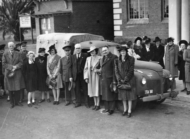
Photograph - Black and white, c.1943
This photograph shows members of the community outside the Moorabbin Council Offices, handing over a brand-new utility truck for use by the Australian Comforts Fund, in support of the war effort. It was purchased with funds raised by contestants in Moorabbin's 'Popular Girl Quest'. Contestants received a vote for each penny they collected. The winner was Gladys Mariott, pictured centre wearing a sash, who raised £528 10s, earning her 126,800 votes. In total, the contestants raised more than a thousand pounds, which enabled the purchasing of the new utility truck.Members of the Moorabbin community were keen to play their part in supporting the war effort. A black and white photograph of a group of men and women standing in front of and behind a utility vehicle with the license plate FA 341. There are two buildings in the background, one of which has a sign out the front that reads "Moorabbin Free Library & Mechanics Institute". The photograph was taken outside Moorabbin Council offices to illustrate the handing over of utility truck for use by Australian Comforts Fund. Money for the truck was raised by the 'Popular Girl Quest' won by Gladys Marriott (centre wearing sash)Handwritten in red ink: A 600 / 72% Handwritten in black ink: CHAP 6. / WITH SUB-STORY / Spy base -- / OR general pix / in Chap 6 / referring to warworld war ii, australian comforts fund, popular girl quest, fundraising, war efforts, vehicles -
 City of Kingston
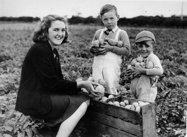
Photograph - Black and white, c.1945
This photograph shows Gladys Marriott, aged 15, in the potato fields of her father's property in Moorabbin. Her cousin Graeme (centre) and younger brother Alfred (right) are with her. Moorabbin is a suburb in the City of Kingston that was originally established as a rural market gardening communityThe Marriott property in Moorabbin was adjacent to a secret wartime wireless receiving station established in March 1942 in Chesterville Road, Moorabbin. The station was established on requisitioned market garden properties, and soon housed WRAN (Women's Royal Australian Navy) personnel and up to 35 US Navy servicemen. The Navy personnel intercepted Japanese coded communications and then despatched these by motorbike messenger to Queens Road, St Kilda where the Directorate of Naval Communications and the code-breaking unit called FRUMEL (Fleet Radio Unit - Melbourne) were housed. The information intercepted by the wireless receiving station helped shape the Allied response to Japan's advances in the Pacific. Declassified defence records show that this unprepossessing station handled some of World War II's most sensitive secrets, however the local community were unaware of its significance. Gladys Marriott, working on her father's property, would regularly take the family's cows to graze in the fields adjoining the station with no concept of what the Navy personnel were doing. Black and white photograph of a young woman and two small boys standing around a wooden crate filled with potatoes. They each have potatoes in their hands. They are standing in a field. Handwritten in red ink: A 601 / 72% Handwritten in black ink: CHAP 6. Handwritten in black ink: GLADYS STOTT (MARIOTT) / DURING WAR YEARS / With Spybase Storymarket garden, children, farming, local production, world war ii, wireless receiving station, moorabbin -
 City of Kingston
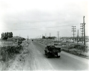
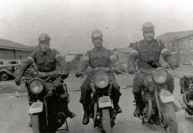
Photograph - Black and white, c.1942
This image shows motorbike despatch riders who were tasked with transporting intercepted Japanese communications from the wartime wireless receiving station established in Chesterville Road, Moorabbin to Queens Road, St Kilda where the Directorate of Naval Communications and the code-breaking unit called FRUMEL (Fleet Radio Unit - Melbourne) were housed. The despatch riders would travel every two hours, all day and night. The wireless receiving station was established in Moorabbin because it was considered an area free of significant electrical interference and was not too far afield from the Melbourne headquarters in Queens Road. Moorabbin was originally established as a rural market gardening community.A secret wartime wireless receiving station was established in March 1942 in Chesterville Road, Moorabbin. The station was established on requisitioned market garden properties, and soon housed WRAN (Women's Royal Australian Navy) personnel and up to 35 US Navy servicemen. The Navy personnel intercepted Japanese coded communications and then despatched these by motorbike riders to Queens Road, St Kilda where the Directorate of Naval Communications and the code-breaking unit called FRUMEL (Fleet Radio Unit - Melbourne) were housed. The information intercepted by the wireless receiving station helped shape the Allied response to Japan's advances in the Pacific. Declassified defence records show that this unprepossessing station handled some of World War II's most sensitive secrets, and the despatch riders were a familiar sight in the Moorabbin area, though few were aware of their purpose. Black and white image of three men in uniform sitting astride three motorcycles in front of cars and buildings. The rider on the right is Jack Barker a local resident. Handwritten in red ink: A 602 / 90% Handwritten in blue ink: SW / 950301111 Handwritten in grey pencil: A 34 CHAP 6 / Spy basemoorabbin, despatch riders, wireless receiving station, world war ii, frumel (fleet radio unit - melbourne) -
 City of Kingston
Photograph - Black and white, c.1914
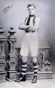
This image is of Arthur Dawson, a well-known local footballer who played for the Fitzroy, St Kilda, Brighton and Moorabbin Football Clubs. As the villages of the Moorabbin area continued to grow and establish, sporting teams for both men and women were created and competitions played. Arthur Dawson went on to play for St. Kilda Football Club in the VFL in 1918, 1919 and 1921. His jumper numbers were 30 and 20. Black and white photograph of a young man wearing a striped football jersey, white shorts, striped knee-high socks and boots. He has his arms crossed and is standing in front of an ornate fence. The date 1914 is underlined in the top lefthand cornerHandwritten in red ink: 30%football, moorabbin, leisure, sport