Showing 3046 items
matching highway
-
 Ringwood and District Historical Society
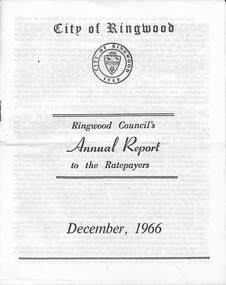
Pamphlet, F.P. Dwerryhouse, Town Clerk and Treasurer, Ringwood Council's Annual Report To The Ratepayers - December 1966, 1966
City of Ringwood community information annual report for 1966, including sections covering Finance, Sanitary Service Charge, Municipal Library, Memorial Clock Tower, Reserves, Civic Centre, Maroondah Highway Reconstruction, Other Road Works, Building Activity and Development - Education, MacRobertsons Pty. Ltd. & Travellers' Facilities (Ringwood Station), Appreciation - Decimal Currency Conversion, Annual Special Clearance of Refuse, Garbage Removal, Fly Control, Immunisations, Infant Welfare Centres, Retention of Native Flora, Home Help Service, Dogs, Horse Riding, Fire Hazards and Burning Off, Secondary School Grants, and list of Council Representatives.rinx -
 Bendigo Historical Society Inc.
Document - VICTORIA POLICE GAZETTES COLLECTION: FROM JANUARY 1874
Victoria Police Gazette No. 4 dated Tuesday, January 27, 1874, containing notices about: murder, incendarism, highway robbery and stealing from the person, housebreaking and stealing from dwelling houses, felonies and offences not otherwise described, miscellaneous information, stealing otherwise than from the person or from dwellings, horses and cattle, property lost, property found, missing friends, escaped prisoners, deserters from merchant vessels and extracts from the New south Wales Police gazette. Also over two page a list of prisoners reported as discharged from the penal establishments during the week ending 26th january, 1874.essential services, police, victoria police gazette -
 Bendigo Historical Society Inc.
Document - VICTORIA POLICE GAZETTES COLLECTION: GAZETTE FROM SEPTEMBER 1868
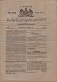
Victoria Police Gazette No. 37 dated Thursday, September 10, 1868, containing notices about: murder, incendarism, highway robbery and stealing from the person, housebreaking and stealing from dwelling houses, felonies and offences not otherwise described, miscellaneous information, horses and cattle, property stolen or lost, missing friends, courts, inquests, deserters from H.M. Service, property found, deserters from merchant vessels, extracts from the New South Wales Police gazette, and extracts from the Tasmanian crime report. Also a list and description of horses and cattle reported to the police as stolen during the week ending 8th September, 1868.essential services, police, victoria police gazette -
 Ballarat Tramway Museum
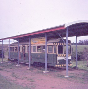
Slide - 35mm slide/s - set of 8, John Theodore, Tram No. 39 at the Lions Pa rk, Lismore, c1973
Yields information about tram 39 following its disposal and how it was sheltered.Set of 8 AGFA blue and white plastic mount 27mm square slides of Tram No. 39 at the Lions Pa rk, Lismore c1973, after the roof has been built over it. See also Reg Item 6545 for photographs of the tram prior to the roof being built over it. .1 - 39 at the park with the shelter looking newly built. .2 - ditto with D3 671 in the background. .3 - end view of the tram, with the highway in the background. .4 - as for .2 .5 - interior view of one end with the controller and brake valves removed. .6 - interior view of the pink paintwork! .7 - ditto .8 - ditto Various notations by John as to the slide number and the trams in pencil and ink.tramways, trams, disposal, lismore, preserved trams, tram 39 -
 Federation University Historical Collection
Book, Final recommendations Ballarat Study Area Land Conservation Council, Victoria, 1982, 1982
Yellow soft covered report of 95 pages . The contents of the report include: Parks, reference areas, wildlife reserves, water production, harwood production, softwood production, flora Reserves and Flora and Fauna reserves, bushland reserves, historic area and reserves, rivers and streams, Roadside conservation and Highway parks, Education areas and School Plantations, Lake Reserves, geological reserves, recreation, scenic reserves, agriculture, mineral and stone production, utilities and survey, township land, Uncommitted Land, military training, other reserves and public land. Maps include: The Study area 1: 250 000 Supplementary Mapsland conservation authority, ballarat, endowment plantations, pine plantations, langi ghiran state park, mount buangor state park, enfield state park, ballarat-creswick regional park, rossbridge, black lake, flax mill swamp, dereel lagoon, lake bolac, lake wongan, langi ghiran reservoir, gong gong reservoir, pincotts reservoir, beales reservoir, wilsons reservoir, moorabool reservoir, korweinguboora, korweinguborra reservoir, learmonth bores, sago hill, illabarook reservoir, ballarat water commission, dunneworthy, mount cole, mont lonarch, ben major, waterloo, trawalla, linton, ross creek, canadian, shepherds flat, lal lal, mount doran, raglan, chute, carngham, buninyong, watsons hill, enfield, cape clear, illabrook, rokewood junction, mount warrenheip, nerrina, jubilee, golden stream, australasian deep lead mine, happy valley school, piggoreet, berringa, bulldog, ballarat common, wildlife, water, timber, flora, rivers, geology, agriculture, warrenheip, biodiversity -
 Melbourne Tram Museum
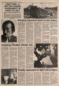
Newspaper, The Emerald Hill, Sandridge and St Kilda Times, "Light Rail: A matter where agreement is hard to get", 23/04/1987 12:00:00 AM
Newspaper cutting from The Emerald Hill, Sandridge and St Kilda Times - 23/4/1987 titled "Light Rail: A matter where agreement is hard to get" about the conversion of the St Kilda and Port Melbourne rail lines to Light Rail. Has three sub-articles, quote the General Manager of The Met Mr. Ed Dotson, Mr Patrick O'Connor Public Transport Users Association about the keeping of the Flinders St link and Mr Noel Willis, the President of the Bayside Public Transport Association who was opposed. Has photos of each of the people involved and a B class tram on route 75 in the Burwood Highway.trams, tramways, light rail, st kilda, port melbourne, conversion, east burwood, route 75 -
 Ringwood and District Historical Society
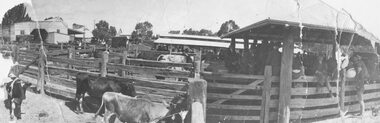
Photograph, Ringwood Market and Saleyards 1914
Black and white photograph (3 copies including original copy in poor condition)Typed below one photograph: "Ringwood Market and Saleyards. Now the site of the new Ringwood Market. Taken from Charter St. looking south east towards corner of Ringwood St. and Maroondah Highway. Old Coolstores in background on left were on Wantirna Rd. - 1914". Typed below another copy: "Ringwood Market - Corner Ringwood St. and Main St. - 1914". -
 Ringwood and District Historical Society
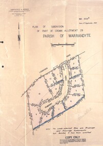
Document - Folder, Pembroke Estate Subdivsion, Ringwood, Victoria - 1964
Manilla folder containing certified copy of Plan of Subdivision dated 2nd September, 1964 - Part of Crown Allotment 29 Parish of Warrandyte, and separate A4 size copy of plan with handwritten 1966 pricing notations. Subdivision includes allotments on Pembroke Court off Loughnans Road, Ringwood.Surveyors - Kirkpatrick & Webber, Civil Engineers & Town Planners, 225 Maroondah Highway, Ringwood, Telephone 8700321. Agents - C.E. Carter & Son RESI., 126 Whitehorse Road, Ringwood (Phone) 87-6024, 87-6830, 870-2519. Folder covernote by Richard Carter - Carter Real Estate - "Vendor - Dale, Plan of Subdivision 68868, sold 23 July 1966." -
 Ringwood and District Historical Society
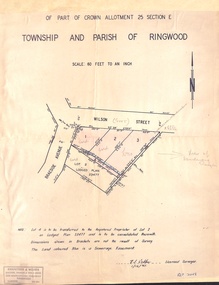
Document - Plan of Subdivision, Part of Crown Allotment 25 Section E, Township and Parish of Ringwood - 1961
Map showing residential allotments numbered 1, 2, 3 and 4, on Wilson Street and Braeside Avenue, Ringwood East, Victoria.Signed and dated 1/12/1961. Rubber stamped Kirkpatrick & Webber, Licensed Surveyors, Civil Engineers & Town Planners, 225 Maroondah Highway, Ringwood, Telephone 870-0321. Ref 3438C. "Note: Lot 4 is to be transferred to the Registered Proprietor of Lot 2 on Lodged Plan 23477 and is to be consolidated therewith." Map also includes handwritten Estate Agent notations. -
 Orbost & District Historical Society
black and white photograph, 1913
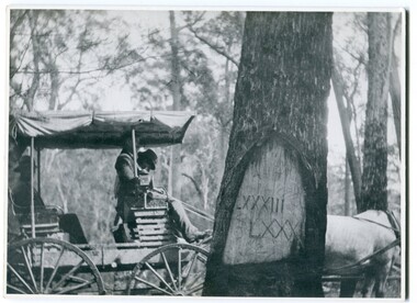
When marking a boundary for a registered plan, a surveyor would place “Reference Marks” with a stated bearing and distance to a boundary corner. These trees were typically marked by cutting the bark of the tree in a shield or blaze. Until July 1886, surveyors were only able to use trees as reference marks to boundary corners. After July 1886 surveyors were able to use “permanent marks” which were either a glass bottle, gas pipe or iron bolt (for homestead surveys only). This photograph shows the reference tree, 83 miles from Marlo via the original surveyed road v ia Sydenham Inlet and Tamboon, south of Mount Drummer to the New South Wales border - now the Princes Highway.This is a pictorial record of an old survet tree. Knowledge of their location, abundance and condition not only provide important insights to past survey practice, but also provide a lasting legacy of a regions land-use history. Old survey trees serve as one of the few remaining physical legacies of early European land settlement history.A large black / white photograph of a horse and buggy pulled up alongside a reference tree which has notches and markings of Roman numerals.on back - " Refernce tree 83 miles from Marlo........to N.S.W. Border"survey-tree reference-tree -
 City of Moorabbin Historical Society (Operating the Box Cottage Museum)
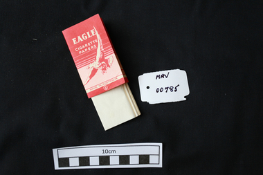
Manufactured objects, Cigarette paper, ‘Eagle’, mid 20thC
Rolling papers are small sheets, rolls, or leaves of paper which are sold for rolling cigarettes either by hand or with a rolling machine. When rolling a cigarette, one fills the rolling paper with tobacco. Rolling papers are most commonly made with wood pulp, hemp, flax, or rice straw as a base material. 1860 Samuel Ramsden, a Yorkshire man, founded first paper mill in Victoria on the banks of the Yarra River, Fairfield, Melbourne. This was the Australian Paper and Pulp Company which for most of its history was called The Australian Paper Manufacturers Ltd. until it changed its name in 1986 to Amcor. In 1919 the company opened its mill on the corner of Upper Heidelberg Road and The Chandler Highway in Fairfield and remains there today. A packet of pre-cut cigarette papers 'Eagle ' brandEAGLE / CIGARETTE / PAPERS / MADE IN AUSTRALIA back 60 PAPERSciagarette papers, cigarettes, tobacco, melbourne, moorabin, paper mills, eagle cigarette papers ltd, australian paper manufacturers ltd, fairfield victoria, -
 Warrnambool and District Historical Society Inc.
Map - An Angler's map of the Hopkins River Estuary, Angler's map Hopkins River, 1980s
This is a map of the Hopkins River Estuary prepared by Dr John Sherwood for the benefit of anglers. The information on the sheet includes the location of sand banks, the water depths, boat ramp facilities and public access facilities. Some of the information has been gathered from aerial photographs. The map has been produced by the Warrnambool Institute of Advanced Education which was developed in the late 1960s from the tertiary section of the Warrnambool Technical College and with all its departments established by 1984 at the Sherwood Campus five kilometres from Warrnambool on the Princes Highway. Today the site is occupied by Deakin University, Warrnambool campus. The Warrnambool Anglers’ Club has its headquarters on the banks of the Hopkins River near the mouth of the river and the Lyndoch Aged Care facility.This map is of interest as a specialist one, providing fishermen with detailed information on all aspects of the Hopkins river estuary. Fishing has been both a profession and a popular recreational pursuit for Warrnambool residents since the early days of the city’s settlement. The Hopkins River Estuary has been a focal point for fishermen throughout Warrnambool’s history. This is a sheet of paper folded three times to produce a folded map. The front cover has a black and white photograph of two fishermen with a large fish. The map of the Hopkins River Estuary is in yellow, blue and black and covers the side of one sheet and three quarters of the other side. There is an advertisement for the Hopkins River Boathouse with a black and white sketch of the boathouse and notes on the map written by Dr John Sherwood. There are several diagrams showing the water depths. The map has some silverfish damage and some tearing at the folds. warrnambool anglers’ club, history of warrnambool, hopkins river, hopkins river estuary, john sherwood -
 Victoria Police Museum
Police Stations (Amherst)
Amherst, a former gold rush town, is located 13 kilometres south-west of Avoca on the Pyrenees Highway in the Pyrenees Shire in Victoria, Australia. It is 183 kilometres north west of Melbourne. The police station, in Camp Street, opened in 1853 and was originally in the District of Castlemaine. In 1857 it came under the District of Avoca, in 1858 the District of Carisbrook, in 1859 the District of Avoca, in 1866 the District of Maryborough, in 1879 the South Western District, and Central District in 1883. The station closed on 8 August 1892. In 1861 the station was staffed by 1 Mounted Constable, 1 Foot Senior Constable and 2 Foot Constables. Amherst "Outstation" opened in 1854 and was part of the Avoca District until it closed in 1856 An outstation was opened in 1854 and closed in 18561 photopolice stations; amherst police station -
 Warrnambool and District Historical Society Inc.
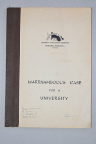
Booklet, Warrnambool's Case for a university, 1961
The information in this booklet was prepared by a University Investigation Committee formed in Warrnambool in 1961 to present the case for the establishment of a university in the Warrnambool area. The chairman of this committee was the Mayor of Warrnambool, Cr P. O’Sullivan and the secretary was W. L. George of Warrnambool. This submission was unsuccessful at the time but campaigning for a university continued. In 1961 Warrnambool Technical School in Timor Street was offering both secondary and tertiary courses in the technical and trades areas and in 1969 the tertiary section of this Technical School became the Warrnambool Institute of Advanced Education. The tertiary section was relocated in 1984 to Sherwood Park, a 94 hectare site on the Princes Highway five kilometres from Warrnambool’s C.B.D. In 1990 Deakin University established a regional campus at Sherwood Park after a merger with the Warrnambool Institute of Advanced Education. This booklet has some historical significance as it contains the information collated on the campaign in Warrnambool and the Western District for a university to be established in the Warrnambool area.This is a soft cover booklet of 48 pages. It has a beige-coloured cover with black printing. The booklet has been bound with brown tape. It has printed information, black and white photographs, a fold-out map, graphs and tables.deakin university, history of warrnambool -
 Ringwood and District Historical Society
Document - Recollection, Unknown, Story of William and James Smith - Ringwood from 1868 to 1920, c.1950
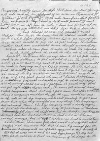
Single page handwritten notes by unknown author briefly outlining family history of William and James Smith in Ringwood from 1868 to 1920. Page ends mid-sentence however no trace of subsequent page/s. Further information on the William and James Smith and family (expanding on these notes?), is contained in the book " A History of Croydon - Second Volume" by Muriel McGivern (pages 170-176) +Additional Keywords: Smith, William / Smith, James / Boardman / Pierce / Robason / antimony William and James Smith were credited for discovering antimony ore near the corner of Mt Dandenong Road and Maroondah Highway, with the main mine later developed by Pierce Boardman. -
 Ringwood and District Historical Society
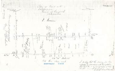
Document - Copy of Lands Department Field Notes - Parish of Ringwood, Victoria, Field Notes 88-9/276 - Part of O.P. R72C surveyed 12.10.1888
Foolscap size photocopy of survey map with handwritten notations. References include - Commencing at bank of creek, Bearing over fence read 134"12', post and rail fence, old round post, Quigley, WB house iron roof, paling & shingle roof, garden, Forshaw formerly Hoare, D Brown, stable & shed, slats & palings, orchard, Occupied by Forshaw, 4 rooms WB Cottage iron roof, Sherbin, Old three chain road, Maroondah Highway, Molloy's corner, I certify that this survey has been effected in accordance with the regulations and that this is a correct copy of my results (signed) - Reed, Assistant Surveyor, 12.10.88. -
 Bendigo Historical Society Inc.
Document - VICTORIA POLICE GAZETTES COLLECTION: GAZETTE FROM AUGUST 1868
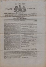
Victoria Police Gazette No. 34 dated Thursday, august 20, 1868, containing notices about: incendarism, highway robbery and stealing from the person, housebreaking and stealing from dwelling houses, felonies and offences not otherwise described, miscellaneous information, horses and cattle, property lost, property found, courts, missing friends, inquests, deserters from H.M. Service, escaped prisoners, deserters from merchant vessels, extracts from the New South Wales Police gazette and extracts from South Australian Police gazette. Also list and description of horses and cattle reported to the police as stolen during the week ending 18th August, 1868.essential services, police, victoria police gazette -
 Bendigo Historical Society Inc.
Document - VICTORIA POLICE GAZETTES COLLECTION: GAZETTE FROM SEPTEMBER 1868
Victoria Police Gazette No. 36 dated Thursday, September 3, 1874, containing notices about: murder, incendarism, highway robbery and stealing from the person, housebreaking and stealing from dwelling houses, felonies and offences not otherwise described, miscellaneous information, horses and cattle, property lost, missing friends, courts, deserters from H.M. Service, property found, extracts from the New South Wales Police gazette, extracts from the Otago Police gazette and extracts from the South Australian Police gazette. Also a list and description of horses and cattle reported to the police as stolen during the week ending 1st September, 1868. The last page is detached.essential services, police, victoria police gazette -
 Ballarat Tramway Museum
Slide - 35mm slide/s, Graham Evans, Sept. 1971
White cardboard mount, 35mm slide, from the Association of Railway Enthusiast's film strip titled "Provincial Tramway Film Strip" of No. 39 inbound along Sturt St. West. with many cars on the road. Bus stop on a pole on the other side of the road. The film strip notes (Reg. Item 2560), provided the following caption details: "Even more dangerous that the lakeside track, for motorists, was the Sturt St West (Western Highway) section of roadside trackage. Car No. 39 faces oncoming traffic on the regular through works to "Mt PLEASANT". - Sept. '71 (Graham Evans)" See image btm2573p.tif for high level scan of image. Stamped on base of slide "11783" and written in ink on top edge "No. 39 Sturt St West Ballarat"tramways, trams, are, film strip, sturt st west, western highway, tram 39 -
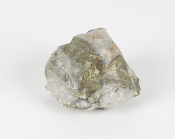 The Beechworth Burke Museum
Geological specimen - Pyrite
This specimen was recovered from Adelong, NSW. The initial discovery of gold at Adelong by a Mr Williams took place in 1857. Much of the area is underlain by granitic rocks, while at Adelong itself a prominent norite intrusive body occurs. To the west of Adelong is a belt of intermediate to mafic igneous rocks and sediments which extends from Batlow in the south to at least as far north as the Snowy Mountains Highway. Around 26 tonnes of gold was found at the Adelong goldfield from its discovery in the 1850s until the last miners left in the 1940s. Pyrite has the formula of FeS2 and forms as an isometric (cube) form. It is a common occurring material and is often mistaken for gold, now colloquially known as ‘fool’s gold’. Pyrite that has strongly crystallised is considered stable, but the mineral has the potential to oxidise and decay. This specimen is part of a larger collection of geological and mineral specimens collected from around Australia (and some parts of the world) and donated to the Burke Museum between 1868-1880. A large percentage of these specimens were collected in Victoria as part of the Geological Survey of Victoria that begun in 1852 (in response to the Gold Rush) to study and map the geology of Victoria. Collecting geological specimens was an important part of mapping and understanding the scientific makeup of the earth. Many of these specimens were sent to research and collecting organisations across Australia, including the Burke Museum, to educate and encourage further study.Pyrite is iron sulphide (also known as “fool's gold”) which is commonly found in slates.Existing Label: 104 /burke museum, beechworth, indigo shire, beechworth museum, geological, geological specimen, mineralogy, pyrite, adelong -
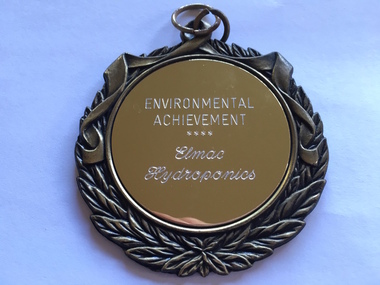 Warrnambool and District Historical Society Inc.
Medallion, Trophy Environmental achievement, 2000
This is a medallion awarded in 2000 by Powercor Warrnambool to Elmac Hydroponics. Powercor Australia, founded in 1994, is an electrical distribution company operating in the Western District of Victoria and the western suburbs of Melbourne. Powercor Warrnambool, like other Powercor organizations, is involved in giving Business Excellence Awards annually to businesses in its area of supply. In 2014 there were 15 awards for Business Excellence. Elmac Hydroponics was a business growing and supplying organically-produced tomatoes from 1997 to 2004. It was situated at Mount Pleasant, Princes Highway, Allansford, Victoria. The business was operated by Graeme and Barbara McLeod and Keith and Leonie Ellerton. Hydroponics is a system of growing plants without soil, using a nutrient solution. Elmac Hydroponics had a 2,000 square metre greenhouse with 10,000 growing points. This is a significant medallion, showing the award given to a small business in the Warrnambool area and indicating its achievements in the environmental area. Elmac was an industry leader in in implementing an ‘Autopot’ hydroponic system which is aimed at reducing nutrient and waste water to zero. Elmac was also a finalist in the Ericsson 2002 Innovation Awards.This is a gilt metal medallion, oval-shaped, with an ornamental edging and a shield-shaped design on one side and a circular design on the other. The top has two metal rings for attachment to a chain or wall hook. On one side: ‘Environmental Achievement, Elmac Hydroponics’ On obverse side: ‘Powercor Warrnambool Region Business Achievement Awards, 2000’ elmac hydroponics, powercor business awards, warrnambool -
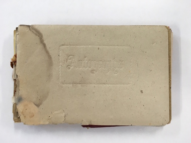 Warrnambool and District Historical Society Inc.
Booklet, Autograph Book, Late 1930s
According to the front page this autograph book belonged to Patricia Spencer of Spencer Street, Dartmoor. Dartmoor is a small settlement on the Princes Highway between Heywood and the South Australian border. It was first settled in the late 1850s and the main industry is the processing of timber from the surrounding pine plantations. Patricia Spencer attended Warrnambool High School in the late1930s and this album contains a number of entries from Warrnambool High School in 1938. It also has a page of eleven signatures of the Head Master, George Langley and other teachers from Warrnambool High School. There are also entries from people from Mortlake and Panmure and other entries with the person’s address not indicated. Autograph books such as this one were commonly owned by young people in the 19th and 20th centuries (up to about 1950) and were very popular with young girls.This album, although incomplete and tattered, is of interest because it is a good example of the social custom, more popular a couple of generations back than it is today, of young people owning and obtaining signatures and verses from their friends and acquaintances. It is also important because it contains signatures of Warrnambool High School teachers in 1938 and there are other entries of interest. This is a small autograph album that was originally bound with a cardboard cover with red leather backing but now has no front cover and only part of the back cover. The pages are all loose and the front section (buff-coloured) has a cardboard piece with felt padding. The pages are coloured in a variety of pastel tones and there are many handwritten entries of verses and signatures, with several from the ‘B’ Form, 1938, of ‘W.H.S. (Warrnambool High School). The album appears to have belonged to Patricia Spencer from Dartmoor. Some of the pages are torn and stained. At the back there are remnants of a sketch of an Asian scene and a letter to ‘Pat’ for her birthday. ‘Autographs’ ‘Patricia Spencer, Spencer Street, Dartmoor’ autograph albums, patricia spencer, warrnambool -
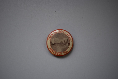 Warrnambool and District Historical Society Inc.
Badge, Back to Port Fairy, 1921
This badge was produced to celebrate a gathering of past and present residents at Port Fairy in 1921, with the event officially called ‘Back to Port Fairy’. Port Fairy is on the Princes Highway, 28 kilometres west of Warrnambool. By 1921 Europeans had settled in Port Fairy for about 85 years, with John Griffiths setting up a whaling station on Griffiths Island in 1836 and James Atkinson establishing the town area in the early 1840s. Atkinson called the town Belfast and it was known by this name until 1887 when the name reverted to Port Fairy. The Back to Port Fairy celebrations in 1921 ran from November 10th to November 19th. A month before, in October 1921, the Glaxo factory, a prominent business in Port Fairy for many years, had been established.This badge is of minor interest as a memento of a celebration at Port Fairy in 1921 and is retained for display purposes.This is a metal badge with red edging, red lettering and a grey-coloured image of boats at the Port Fairy wharf. Back to Port Fairy November 1921port fairy, history of warrnambool, badge, port fairy -
 Glen Eira Historical Society
Document - Classic Retirement Village, Brighton
Four documents about the history of this site pre Classic Retirement Village: 1/A copy of a description of the sale process of the Gascor site, cnr Nepean Highway and Thomas Street, to Becton Corporation in 1997 And 1998. Printed on 31/07/2010 from the Victorian Auditor General’s Department website with aerial photograph 2/A copy of page one of the Gleneira Planning Scheme dated 19/01/2006 which mentions the Gascor site. 3/Research note by Andrew Frederick dated August 2010 listing occupiers of the site in the 1960 and the 1970 Sands and Mc Dougall Directories. 4/Research note by Claire Barton dated May 2010 containing Ian Swan’s recollections of working at Daylesford Worsted Woollen, occupier of the site, in the 1960s.thomas street, brewer road, bentleigh, gascor, becton corporation pty ltd, virginia park, gas and fuel, hughesdale dairy, east boundary road, moorabin, east bentleigh, hooblerstone, clairmont avenue, glen eira, daylesford centenary woollen and worsted mills pty ltd., nepean highway, f and j industries australia plastic and rubber division., swan ian, korman stanley, mills, wool industry, weaving mills, textile factories, textile manufacturing, manufacturing industry -
 City of Moorabbin Historical Society (Operating the Box Cottage Museum)
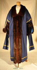
Ceremonial object - City of Moorabbin Mayoral Robe c1960, circa 1960
This robe was the last City of Moorabbin Mayoral Robe, and was worn by Mayor Ron Brownlees, (prior to the City of Moorabbin's amalgamation with City of Glen Eira and City of Kingston in 1994). It was donated to the City of Moorabbin Historical Society in February 2007 by the City of Kingston. 12/11/2018 Cr Steve Staikos MAYOR City of Kingston requests that CMHS loan the Mayoral Robes and Jabot with Cuffs for display at KCC Officess Nepean Highway Cheltenham on going 7 Years. The Moorabbin Mayoral Robe with Jabot is displayed along with those of former City of Chelsea Robes and former City of Mordialloc Robes at Kingston City Council Office . The KCC possesses the Mayoral Chains of each former Council and they are displayed on the Mayoral Robes for the Annual Opening meeting of KCC in February .The City of Moorabbin developed from the Moorabbin Roads Board of 1862, becoming The Shire of Moorabbin in 1871 and the City of Moorabbin in 1934. In the 1994 Amalgamation of Councils the City of Moorabbin was divided between the new City of Kingston in the South and the new City of Glen Eira to the North . This is the last Mayoral Robe for the City of Moorabbin 1934- 1994City of Moorabbin Mayoral Robe. Full length garment of royal blue material, 55% Polyester & 45% Wool, with gold braid on hem and sleeves. Full length Collar and the cuffs are brown mink and sleeves are lined with blue satin. Two brass clips on shoulders are for the attachment of the Mayoral Chain. Hook and eye fasteners join the front of the robe. This is the last City of Moorabbin Mayoral Robe and was worn by Mayor Ron Brownlees, (prior to amalgamation in 1994), and donated to the City of Moorabbin Historical Society in February 2007 by the City of Kingston. 2018 the Robe with jabot was moved to Kingston City Council Office Cheltenham for display with former City of Chelsea Robe and former City of Mordialloc Robe. Label " Raymond W. Bredin & Son / 17 Glenola Road / CHELSEA VIC. AUSTRALIA / Robe Makers "clothing, tailors, formal wear, moorabbin, kingston, mayor, city of moorabbin, robes civic, moorabbin roads board, shire of moorabbin, brownlees ron, city of glen eira, city of kingston -
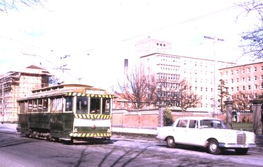 Ballarat Tramway Museum
Slide - Set of 6, Warren Doubleday, Ballarat - last Saturday of full operations, 21/8/1971
Photos taken on the last Saturday of full operations by the SECV in Ballarat prior to the first closure of the Victoria St line on 22/8/1971. 1 - Tram 32 Drummond St North with Hospital behind. 2 - Tram 33 passing a Licensed grocer in Lydiard St North. 3 - Trams 27 and 33 Lydiard St North with the Railway Hotel, Cuthbert's solicitors offices, Norman J Ford with a Griffiths Tea and McAlpine flour adverts, and a commercial college in the background. 4 - Tram 33 on the Lydiard St level crossing while the down pass awaits with S305 5 - Tram 11 waits for S305 to pass through the level crossing. 6 - S302 and S300 on up interstate goods with the new highway overpass bridge being constructed.Yields information about the last full Saturday of SEC Tramway operations in Ballarat and has a strong association with the archivist. Set of 6 Kodachrome colour slides - cardboard mountsHave the photographer's slide numbers written on them.trams, tramways, closure, tram 32, tram 33, tram 27, level crossing, lydiard st north, tram 11, railways -
 Chelsea & District Historical Society Inc
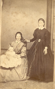
Photograph - Morton Family, Mr Alfred Morton with his mother and aunt, c 1866
Alfred Louis Morton (known as Louis) was born in Geelong in 1866, the fifth of eleven children of Mark Morton and Eliza nee Heard (married 1898). Alfred began work for the Post Office at South Yarra in the 1890s. In the late 1800s it was common for people from Melbourne and north of the city to travel to Chelsea area beaches for their holidays and many liked the area so much that, like the Mortons, they moved here permanently. In the 1890s Alfred’s sister, Mrs William Ashmore, built a weekend house at the foot of what is now Foy Avenue in Chelsea. The Morton family, including Alfred, visited the area often, camping on the foreshore during the 1890s. In 1911 Alfred moved his family permanently to a house on the corner of Morton Grove and Main Road Chelsea (now known as the Nepean Highway) on property that extended from the main road to the beach. This house was destroyed in the fire of 22 December 1913 which raged amongst the ti-tree on the foreshore between Aspendale and Chelsea. Many buildings were destroyed in this fire. The Argus newspaper reported on Wednesday 24 December that 94 houses were burnt with glowing embers blown a mile and half inland. According to the Argus but for the wide break provided by the Point Nepean Road (now the Nepean Highway) and the railway line, the scrub on the other side might have caught. The Morton children, Elsa and Ivan, attended Chelsea State School (now Chelsea Primary School) and Mrs Morton was active in the establishment of St Chad’s Church of England in Chelsea. At the age of 80 in 1945 Mr Morton was concerned about reports that English children had lost their toys due to the war and so he made (as part of a wider effort in Australia) 100 toy engines that were sent to England. He died in 1946 in Chelsea. Sepia photograph of Mr Alfred Morton as a baby, on the lap of his mother, Eliza, sitting on a chair, and his aunt, standing.morton, mr alfred louis morton -
 Chelsea & District Historical Society Inc
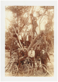
Photograph - Mr Alfred Morton with his brothers and friends, Bike picnic at Morton's property, c 1890
Alfred Louis Morton (known as Louis) was born in Geelong in 1866, the fifth of eleven children of Mark Morton and Eliza nee Heard (married 1898). Alfred began work for the Post Office at South Yarra in the 1890s. In the late 1800s it was common for people from Melbourne and north of the city to travel to Chelsea area beaches for their holidays and many liked the area so much that, like the Mortons, they moved here permanently. In the 1890s Alfred’s sister, Mrs William Ashmore, built a weekend house at the foot of what is now Foy Avenue in Chelsea. The Morton family, including Alfred, visited the area often, camping on the foreshore during the 1890s. In 1911 Alfred moved his family permanently to a house on the corner of Morton Grove and Main Road Chelsea (now known as the Nepean Highway) on property that extended from the main road to the beach. This house was destroyed in the fire of 22 December 1913 which raged amongst the ti-tree on the foreshore between Aspendale and Chelsea. Many buildings were destroyed in this fire. The Argus newspaper reported on Wednesday 24 December that 94 houses were burnt with glowing embers blown a mile and half inland. According to the Argus but for the wide break provided by the Point Nepean Road (now the Nepean Highway) and the railway line, the scrub on the other side might have caught. The Morton children, Elsa and Ivan, attended Chelsea State School (now Chelsea Primary School) and Mrs Morton was active in the establishment of St Chad’s Church of England in Chelsea. At the age of 80 in 1945 Mr Morton was concerned about reports that English children had lost their toys due to the war and so he made (as part of a wider effort in Australia) 100 toy engines that were sent to England. He died in 1946 in Chelsea. Sepia photograph of Mr Alfred Morton with his brothers in law and friend at Carrum in the 1890's, some perched in a tree others grouped at the base of the tree, bikes in the foreground.bike riding, picnic, morton, morton grove, chelsea, carrum -
 Eltham District Historical Society Inc
Photograph, M. North, Main Road, Eltham near Fitzsimons Lane Roundabout, Dec 1985, 1/12/85
Two colour photographs of Main Road, ElthamSouth between Falkiner Street and Bolton Street at the roundabout of Fitzsimons Lane, Eltham, Dec 1985Noted on 463B 'See 1934 small black and white snap of flooded bridge and the same two shops. This snap taken from same location, Dec 1985. Old Eltham Park on right of photo The two shops at left (Ansel and Muir) Road ahead crosses new bridge over the Diamond Creek, Eltham Main Road now dual highway, through Lower Plenty to this bridge'main road, eltham, eltham south, fitzsimons lane, round about, falkiner street -
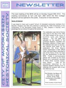 City of Moorabbin Historical Society (Operating the Box Cottage Museum)
Newsletter - City of Moorabbin Historical Society Aug 2012, August 2012
The City of Moorabbin Historical Society was formed c 1960 by a group of Moorabbin area residents who were concerned that the history of the area should be preserved. A good response to a call for items related to the historical area of Moorabbin Shire brought donations of a wide variety of artefacts that are now preserved by the current members of CMHS at Box Cottage Museum. Helen Stanley, Secretary of CMHS, began producing a Newsletter for members in April 2007 to provide current information and well researched items of historical interestHelen Stanley has produced a bi-monthly Newsletter, 2007 - 2013, for the members of the City of Moorabbin Historical Society that contains well researched interesting historical items, notification of upcoming events, current advice from Royal Australian Historical Society , Museums Australia Victoria and activities of Local Historical Societies. The Newsletter is an important record of the activities of the CMHS1 x A4 paper printed on 1 side Issue 28 of the bi-monthly, City of Moorabbin Historical Society Newsletter produced by Society member and Secretary, Mrs Helen Stanley in August 2012 with photographs of the Ceremony celebrating the 150th Anniversary of the formation of The Moorabbin Roads Board. The Mayors of Glen Eira, Kingston and Brighton unveiled a Plaque at the corner of Cummins Road and Nepean Highway near the original site of the 'Toll gate' . Members of each Historical Society were present including past president of CMHS, His Worship the Mayor of Glen Eira Jamie Hyams. Notes of life at Box Cottagec1918 - 1950 by Stefanie Rennick, nee Reitman, that she donated to CMHS. CITY of MOORABBIN HISTORICAL SOCIETY / AUGUST 2012 NEWSLETTER city of moorabbin historical society, stanley helen, melbourne, moorabbin, brighton, cheltenham, ormond, bentleigh, market gardeners, pioneers, early settlers, the moorabbin roads board 1862, city of glen eira, city of kingston, moorabbin shire, parish of moorabbin, brighton east, south brighton, bent tommy, mair william, jessse morleys hotel, box henry, box william,