Showing 6992 items matching "historic"
-
 Ballarat Diocesan Historical Commission
Journal, Journal "Light", 1964
The Ballarat Diocese monthly journal "Light" was published from 1948 - 1986. The example from a complete collection is from 1964 and features one of the many hundreds of artistic and historic photographs taken by Monsignor J. McInerny that he used throughout but particularly for cover images. -
 Port Melbourne Historical & Preservation Society
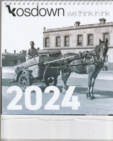
Document, Kosdown we think in ink 2024, 2023
The 2024 Kosdown calendar celebrates Port Melbourne and pays tribute to Pat GRAINGER and her contribution to the community and the Port Melbourne Historical & Preservation Society. Historic photographs include Swallow & Ariell's factory, motor racing at Fishermans Bend, and Mitchell's London Family Hotel.Spiral bound 2024 calendar on a stiff white cardboard stand. The cover has a photo of William STUART on his milk float and horse 'Goatie'..business & traders - dairies, kosdown press, pat grainger, business and traders - hotels, business & traders - manufacturing, mitchell's london family hotel, sport - motor racing, william raeburn stuart, goatie, swallow & ariell ltd, london family hotel -
 Sunbury Family History and Heritage Society Inc.
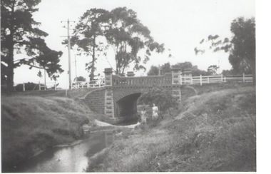
Photograph, Rosa McCall, Moonee Ponds Creek, 1949
The single arched stone bridge spans the Moonee Ponds Creek in the former Old Broadmeadows Township, now Westmeadows. The historic bridge is in Fawkner Street, and has a heritage classification. The Moonee Ponds Creek flows from the upper reaches of Greenvale and flows into the Yarra at Docklands.The stone bridge over the Moonee Ponds Creek was erected in 1869 and replaced a less substantial one.A black and white print of a non-digital photograph of a stone single-span bridge spanning a creek. White post-and-rail fence has been constructed ion either side of the bridge. Pine trees are growing on then creek banks.moonee ponds creek, old broadmeadows township, bridges, fawkner street, westmeadows -
 Eltham District Historical Society Inc
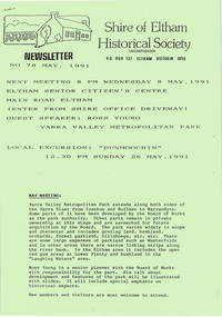
Newsletter, Newsletter, No. 78 May 1991
Contents: • Next meeting, guest speaker; Ross Young: Yarra Valley Metropolitan Park • May Meeting • Dunmoochin Trip • Annual general Meeting • Subscriptions • Neil Blair • Shire Heritage Study • Planning Controls – Historic Buildings and Significant Trees • Other Society News The Shire of Eltham Historical Society was formed in October 1967. The first newsletter of the Society was issued May 1978 and has been published continuously ever since on a bi-monthly basis. With the cessation of the Shire of Eltham in late 1994, the Society's name was revised to Eltham District Historical Society and this name first appeared with issue No. 103, July 1995. The collection of the Society's newsletters provides a valuable resource on the history of the Society's activities, office bearers and committee members, guest speakers and subjects of historical interest pertinent to the former Shire of Eltham and the Eltham District.A4 photocopied newsletter distributed to membersnewsletter, eltham district historical society, shire of eltham historical society -
 Puffing Billy Railway
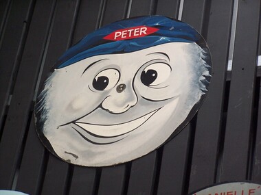
Locomotive Name Board - Peter
Historic - Puffing Billy Railway Locomotive Head Board used in the Celebration of Special Children's train days Wooden Train Headboard - Peter - face used on special Children's trains hauled by former Gas Works locomotive Sir John Grice - alias Peter Peckett.Historic - Puffing Billy Railway Locomotive Head Board used in the Celebration of Special Children's train days Locomotive Head Board - Peter painted Wooden Train Headboard - Peter - facePeterpuffing billy, peter, special children's train day -
 Kew Historical Society Inc
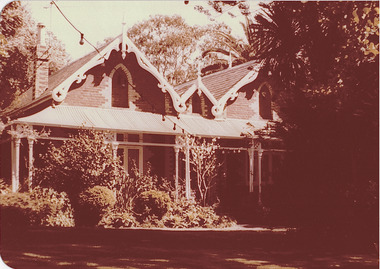
Photograph - 'Roseneath', 37 Pakington Street, 1979
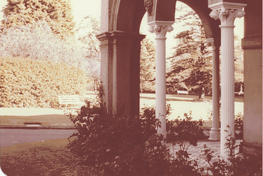
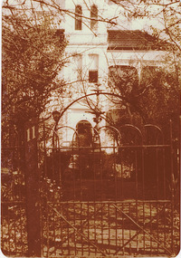
In 1979, a series of photographs of significant gardens in Kew (Victoria) were taken during a tour by Peter Watts, Historic Gardens Coordinator of National Trust Victoria. These were later purchased to add to the collection. In the case of each photo the colour had badly degraded over time. Original colour (degraded) positive photograph of 'Roseneath', 37 Pakington Street Street, Kew.Annotated in ink reverse: "Roseneath Pakington St / View of home from front / Mr Creed owner / Oct 1979"gardens -- kew (vic.), roseneath, 37 pakington street -- kew (vic.) -
 Kew Historical Society Inc
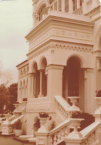
Photograph - 'Burke Hall', (formerly 'Studley Hall', 'Waverley'), Nolan Avenue, 1979
In 1979, a series of photographs of significant gardens in Kew (Victoria) were taken during a tour by Peter Watts, Historic Gardens Coordinator of National Trust Victoria. These were later purchased to add to the collection. In the case of each photo the colour had badly degraded over time. Original colour (degraded) positive photograph of 'Burke Hall' [Xavier College], (formerly 'Studley Hall', 'Waverley'), Nolan Avenue, Kew. A view of the south facing facade. Annotated in ink and pencil reverse: "Burke Hall once Waverley / Early 1870s / in 1903 name changed to Studley Hall / 1926 Burke Hall / Oct 1979"gardens -- kew (vic.), burke hall, studley hall, waverley, nolan avenue -- kew (vic.) -
 Kew Historical Society Inc
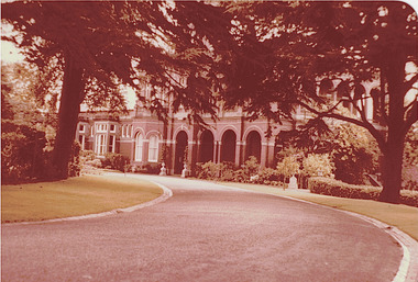
Photograph - 'Raheen', Studley Park Road, 1979
In 1979, a series of photographs of significant gardens in Kew (Victoria) were taken during a tour by Peter Watts, Historic Gardens Coordinator of National Trust Victoria. These were later purchased to add to the collection. In the case of each photo the colour had badly degraded over time. Original colour (degraded) positive photograph of 'Raheen', Studley Park Road, , Kew. A view of the south facing facade. Annotated in ink on reverse: "Raheen Front View with sweeping driveway / Oct 1979"gardens -- kew (vic.), raheen, studley park road -- kew (vic.) -
 Kew Historical Society Inc
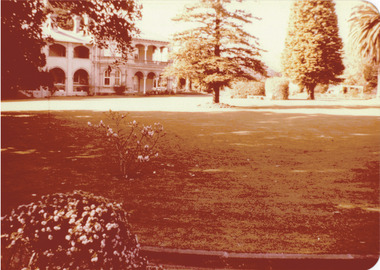
Photograph - 'La Verna', (formerly 'Heathfield'), Sackville Street, 1979
In 1979, a series of photographs of significant gardens in Kew (Victoria) were taken during a tour by Peter Watts, Historic Gardens Coordinator of National Trust Victoria. These were later purchased to add to the collection. In the case of each photo the colour had badly degraded over time. Original colour (degraded) positive photograph of 'La Verna', (formerly 'Heathfield'), Sackville Street , Kew.Annotated in ink on reverse: "Laverna (Retreat) / Front view of vast lawns, huge pines, home beyond / Taken by P Watts, National Trust / Purchased by Society Oct 1979."gardens -- kew (vic.), heathfield, la verna, sackville street -- kew (vic.) -
 Kew Historical Society Inc
Photograph - 'La Verna', (formerly 'Heathfield'), Sackville Street, 1979
In 1979, a series of photographs of significant gardens in Kew (Victoria) were taken during a tour by Peter Watts, Historic Gardens Coordinator of National Trust Victoria. These were later purchased to add to the collection. In the case of each photo the colour had badly degraded over time. Original colour (degraded) positive photograph of 'La Verna', (formerly 'Heathfield'), Sackville Street , Kew.Annotated in ink on reverse: "Laverna Retreat Sackville St / View of sweeping rows of trees, lawn through portico / Purchased by Society Oct 1979."gardens -- kew (vic.), heathfield, la verna, sackville street -- kew (vic.) -
 Kew Historical Society Inc
Photograph - 'Inverkelty', Redmond Street, 1979
In 1979, a series of photographs of significant gardens in Kew (Victoria) were taken during a tour by Peter Watts, Historic Gardens Coordinator of National Trust Victoria. These were later purchased to add to the collection. In the case of each photo the colour had badly degraded over time. Original colour (degraded) positive photograph of 'Inverkelty' (later Kiora, Baroona), 11 Redmond Street , Kew. The original attribution of the house as Red Bluff (or Yarra Bluff) owned by the Nott family is incorrect. An analysis of ownership from 1888 was completed by Lovell Chen (2005), Boroondara Heritage Review B Graded BuildingsAnnotated in ink on reverse INCORRECTLY AS : "Red Bluffs / 11 Redmond Street / Nott family 1888 / Front garden with fountain / Home in foreground / October 1979"gardens -- kew (vic.), inverkelty, kiora, redmond street -- kew (vic.), baroona -
 Orbost & District Historical Society
magazine, Australia Album -The Past In Pictures, circa 1974
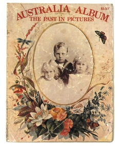
The magazine was produced as a tribute to Lillian Roxan who was a great Australian and an international journalist. It is not dated but was published by Sungravure Pty Ltd circa 1974-75, The editor, Ailsa Craig wrote for the the magazine Woman's Day in the 1950s and 60s. she had an active career in journalism from 1960-1980. it contains b/w and sepia photographs. This magazine style paperback book contains photos of an earlier Australia.A paper magazine - AUSTRALIA ALBUM -THE PAST IN PICTURES. It contains prints of historic photos. On the front cover is a portrait of three young children dressed in early 19th century clothing. This is inside an oval frame with a gold border. There is a wreath of colourful flowers and butterflies surrounding this.The title is printed in red at the top. In the top right-hand corner is the price $1.50. It was edited by Ailsa Craig and contains photos and text from readers of Womans Day, The Sydney Morning Herald, the Sydney Mitchell Library and the Department of the Army. The magazine style book has 94 pp.magazine photos roxon-lillian craig-ailsa -
 Wycheproof & District Historical Society Inc.
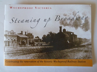
Railway Booklet, Steaming Up Broadway, 31/10/2010
Celebrating 125 years of Railway in WycheproofThe 28-09-1883 was a memorable date for Wycheproof for on that day the long-awaited official opening of the railway took place. It has been serving the district since then. In this booklet individual rail workers are acknowledged in a listing.Booklet of 14 pages - size A5. Sepia front cover photo depicts steam train hauling rail trucks up Broadway, Wycheproof, with early buildings and horse- drawn carriages showing. Back cover: Wycheproof Railway Station in its early beginnings - undated. Booklet celebrates the renovation of the historic Wycheproof Railway Station and 125 Years of Rail in Wycheproof. Chapters include: The Early Days, The Arrival of Rail, The New Century, Bulk Wheat and Million Bushell Silos, Railway Families and Workers, The Last Chapter , A new Era Begins. rail-wycheproof, bulk-wheat, railway-workers, station-renovation, steam-train -
 Federation University Historical Collection
Report, Wendy Jacobs et al, The Pyrenees Shire Avoca Shire Study 1864-1994 Volume 3, 1995, 1995
.1) Copy of Volume 1 of the Avoca Shire Heritage Study which outlines the enviromental history of the shire including gold, water, farming. wine and fruit, towns, road and rail, and extractive industries. .2) Copy of Volume 3 The Avoca Heritage Study which was commissioned by the National Estate Committee. Voume Three contains documentation on individual sites whoch reflect themes outlined in the Environmental History (Volume One). These sites are recommended for protectins under the Local Planning Scheme or the provisions of the Historic Buildings Act. The sites are arranged by geographical location, then, alphabetically by road.wendy jacobs, karen twigg, avoca, bung bung, homebush, crowlands, landsborough, moonambel, natte yallock, navarre, barkly, ]percydale, redbank, mountain creek, nettyalloc, green hills, glendhu, djadja wurrung, djab wurrung, hugh glass, glenmona, charles williamson, woodlands, william degreaves, chinese, mining, ironbark mine, homebush deep lead mine, ampitheatre, dredging, water, mashado's well, ellen allan, hunter's hime, wine, fruit, mackereth's vineyard, orchards, viticulture, edwin mackereth, john costello, w.a. adams, chateau remy, david rodwell, schools, education, churches, road, rail, avoca road districy board, ben nevis, eucalyptus distelleries, jim farnsworth, ned gollop, reg harvey, heritage study -
 Bendigo Historical Society Inc.
Document - AULSEBROOK COLLECTION: STATE BANK BENDIGO OPENING INVITATION, 1978
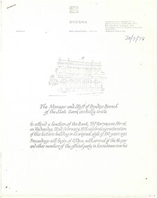
Aulsebrook Collection: State Bank, Bendigo Opening Invitation Title: The Manager and Staff of Bendigo Branch of the State Bank cordially invite… to attend a function at the Bank: 337 Hargreaves Street, Wednesday, 22nd February 1978, Celebrating restoration of this historic building in its original style of 100years ago. Proceedings will begin at 4:30pm with arrival of Mayor and other members of the official party in horsedrawn coaches. -A4,5 white pages, typed -Detailed booklet of information regarding event, history of the bank, information about the restoration project, and photocopy of newspaper clipping relevant to Bank. -
 Whitehorse Historical Society Inc.
Newspaper - Article, Mural - Spencer St Station, 13/01/1978
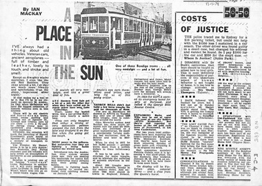
Australia Day 1978 Melbourne had the biggest collection of historic vehicles seen in this country. There were electric and horse drawn trams, steam trains, veteran and vintage cars and even a fly past of old flying machines. Officially the occasion marked the unveiling of Harold Freeman's giant mural at Spencer Street Station depicting a century of transportation in Australia. Another paragraph refers to the horse trough referred to in E - C - 3 and research by Amy Bunker into the story of George Bills. It points out that the RSPCA emergency home in Burwood is the George Bills Rescue Centre.transport, freeman, harold, spencer street station, horse troughs, bills, george, royal society for the prevention of cruelty to animals, bunker, amy -
 Ballarat Tramway Museum
Photograph - Black & White Photograph/s, c1907
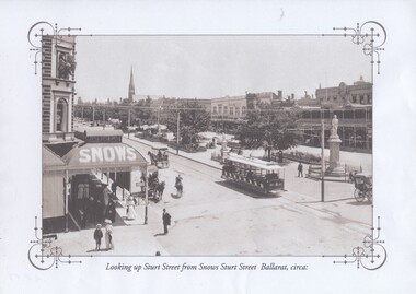
Yields information about Sturt and Lydiard St North intersection, mid to late 1920's, centre poles and condition of the streets and car parking arrangements.Black and white historic photograph downloaded from a picture resource website within a decorative frame. Printed with an inkjet printer. Titled "Looking up Sturt Street from Snows Sturt Street Ballarat, circa:" Original photograph taken soon after opening of the tramway in Sturt St., no windows and no destination box on the roof of the tram. Has a number of horse drawn vehicles in the photograph. On the left hand side of the photograph is Snows building. At the corner of Armstrong Street Original photo from a postcard - see Reg Item 2791 for a oval shape view. trams, tramways, armstrong st, snows, sturt st, toastrack tram, tram 20 -
 Kew Historical Society Inc
Map, MMBW, MMBW Plan No.40 Collingwood & Kew, 1900-1910
The Melbourne and Metropolitan Board of Works (MMBW) was established by an act of the Victorian Parliament in 1890 to prepare for and to implement a sewerage and water reticulation system across what was then inner Melbourne, its surrounding and middle distance suburbs, including Kew. The MMBW was disbanded in 1991.The map collection of the Kew Historical Society has at its core the historic maps assembled and originally stored in the City Engineer's Department of the City of Kew. These include maps in a number of scales. The vast majority of maps were produced by the MMBW in the first two decades of the twentieth century, and are solid working maps, backed by linen for durability. These maps are historically significant to Kew, the City of Boroondara and to the history of the development of state utilities in Victoria. A number of the Kew maps have additional details added by former municipal officers, including the levels reached by various floods. As these were working documents, information was added to them long after the period of their initial production and distribution.Early map of part of the Borough of Kew, created in the first decade of the twentieth century, at a scale 160 ft to 1 inch. The map covers what was then the south western section of Kew, bordered on its north by Studley Park Road, in the west by Walmer Street and the River Yarra, by High Street South and Princess Street in the East and Barkers Road in the south. The map shows the extent of urban development by that time, prominent institutions and the outlines of built structures in the municipality. Contour lines and historic flood levels were added in ink to the map at a later stage.MELBOURNE AND METROPOLITAN BOARD OF WORKS / PLAN NO. 40 / COLLINGWOOD & KEWmelbourne & metropolitan board of works, mmbw maps, mmbw plans, borough of kew, cartography -
 Melbourne Tram Museum
Book, Keith Kings, "Bendigo's Vintage Talking Trams", 1999
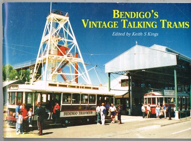
Book - 100 pages, plus printed colour covers on gloss paper, centre stapled, titled "Bendigo's Vintage Talking Trams", authored by Keith Kings1996, published by the Bendigo Trust December 1981. Has many historic photos of Bendigo, trams in the streets of Bendigo and its then fleet of trams. Gives a history of the trams in Bendigo, including battery tram, steam, ESCo, SEC, the Trust, Central Deborah Gold Mine and its trammies. Pages 49 to 52 - colour pages including a map of the route and staff and volunteers 30/10/1996.Page 1 note in ink "To Charles 20/2/97 Keith Kings"trams, tramways, bendigo, battery trams, bendigo trust -
 Bendigo Historical Society Inc.
Document - VICTORIA HILL - VICTORIA HILL IRONBARK
Typed copy of notes on Victoria Hill, Ironbark and New Chum Hill - An Historic Landmark. Notes include locality, some of the early mines, their depth, gold produced, dividends paid, vertical winding engine and crushing battery. Mines mentioned are: Rae's, Wittscheibe and Company 'Jeweler's Shop', the Advance, Cinderella Mine, Lansell's 180, North Old Chum, Victoria Quartz, Burrowes and Sterry's, Lazarus' Claim, Gibbs and Lazarus, Bonatti's, Menzies, Hildebrandt and Kock's, Ellesmere, Old Chum, New Chum and Victoria, New Chum United, New Chum Consolidated and the Garibaldi.document, gold, victoria hill, victoria hill ironbark, rae's, wittscheibe and company 'jeweller's shop', hopetoun band room, advance, cinderella mine, geo lansell, lansell's 180, new chum hill, fortuna mansion, new chum drainage association, north old chum, b c v 8 television studio, royal survey regiment, burrowes and sterry, lazarus claim, gibbs and lazarus, bonatti's, menzies, hildebrandt and kock's, ellesmere, old chum, p m g repeater station, ballerstedt, mr geo lansell, new chum and victoria, phoenix, mt alvernia hospital, new chum united, new chum consolidated, garibaldi, mr clarke magee -
 Working Heritage Crown Land Collection
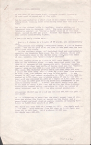
Award - Royal Mint Building Award, JA Dodd Excellence in Construction
2002 Excellence in Construction AwardsFramed Award 2002 Excellence in Construction Awards, JA Dodd LTD, Excellence in Construction, (Existing Buildings) Under $2 million, Project: The Royal Mint Building, Architect: Robert Peck von Hartel Trethowan, Location: 280 William Street Melbourne, J A Dodd Ltd's refurbishment of the historic former Royal Mint Building delivered to the client's specification in retaining the features of this historic building, while at the same time providing modern office accommodation with state of the art facilities. New works have been defined by a modern style encompassing glass, stainless steel and flush surfaces, offering a stark departure from the ornate finishes of the original building. Traditional timber mouldings, tiles stonework and intricate paint methods have been used only where repairs to the existing building were required. The judges praised the superb job and made special mention of the exposed roof trusses. 38 master builder awards -
 Eltham District Historical Society Inc
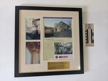
Newsletter, Newsletter, No. 184 January 2009
Contents: • Next meeting, guest speaker; Noel Withers: Historic Greensborough • February Meeting • President’s Findings by Harry Gilham • The Eltham Omelette Joust • News from the Andrew Ross Museum by Diana Bassett-Smith • Celebrating Nillumbik’s Women • Other News • Annual General Meeting The Shire of Eltham Historical Society was formed in October 1967. The first newsletter of the Society was issued May 1978 and has been published continuously ever since on a bi-monthly basis. With the cessation of the Shire of Eltham in late 1994, the Society's name was revised to Eltham District Historical Society and this name first appeared with issue No. 103, July 1995. The collection of the Society's newsletters provides a valuable resource on the history of the Society's activities, office bearers and committee members, guest speakers and subjects of historical interest pertinent to the former Shire of Eltham and the Eltham District.A4 photocopied newsletter distributed to membersnewsletter, eltham district historical society, shire of eltham historical society -
 Robin Boyd Foundation
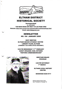
Document - Manuscript, Robin Boyd, The Rape of Nareeb, 1965
Discusses the Estate of Nareeb, Kooyong Rd; 1888. The National Trust is disinterested, land denuded and house demolished, and there is needless destruction of natural and historic relics for redevelopment, particular destruction of trees exclusive to Australia. Boyd says it shows no consideration for future residents; innocence and undemanding passivity of consumers.Original manuscript of an article published as 'The Rape of Nareeb' in The Australian in 06.03.1965.Typewritten, quarto, 6 pagesnareeb, kooyong rd; national trust; destruction of natural historical environment; redevelopment, robin boyd, manuscript -
 Sunbury Family History and Heritage Society Inc.
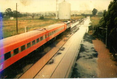
Photograph, 17 December 1985
On 17th December 1985 record torrential rain fell in Sunbury, which flooded the main Melbourne Bendigo rail line and disrupted traffic. The photograph is looking to the north of the station and takes in the historic Macedon Street bridge and the open ground with the storage silo on the west side of the railway line. A coloured photograph of a former V Line train stopped at a station where the railway line has been flooded. A storage silo occupies vac ant ground adjacent to the railway line.sunbury railway station, storage silos, horne street -
 Wangaratta RSL Sub Branch
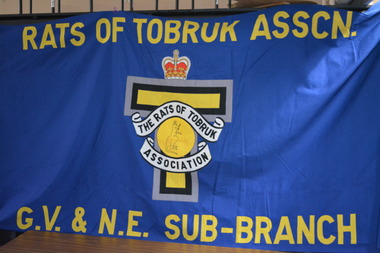
Banner, Rats of Tobruk
During World War 2, more than 14,000 Australians fought at Tobruk (Libya), during the historic 242 day siege. These men became famously known as the Rats of Tobruk. After returning to Australia, the Tobruk siege servicemen looking for comradeship, established the Rats of Tobruk Association. Around 1944, active branches and sub-branches were started in every state. In more recent times, these branches and subbranches have been wound up owing to the declining numbers of surviving veteran members. The only exception has been the Victorian Branch, which has now operated for over 70 years.Large blue cloth banner housed between two timber poles. In the centre of the banner there is a crown above a grey,black and yellow T shape overlaid by a crest with a kangaroo in a yellow circleRats of Tobruk Assoc GV & NE Sub Branchrats of tobruk, ww2 -
 Hymettus Cottage & Garden Ballarat
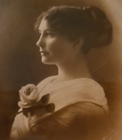
Work on paper - Photograph, Agnes Taffe
Portrait photograph with artistic brushwork by Ballarat photographer Thornton c.1917. Thornton & Richards were one of Ballarat's major photographic studios and their work and historic records of schools, sporting and civic events remain a major record of social and family life in Ballarat region over a century.Thornton & Richards were one of Ballarat's major photographic studios and this is an exceptional demonstration of their portraiture.portrait -
Phillip Island and District Historical Society Inc.
Transparencies, 1990's
10 Transparencies in good condition but of a size not currently in use.10 Slides featuring chicory farming around, it is believed, the kiln on Thompson Avenue built for Gordon West in 1943.local history, photography, photographs, slides, film, buildings, historic, rural industry, agriculture, early slides, chicory farming, chicory kilns, phillip island -
Phillip Island and District Historical Society Inc.
Transparencies, 1990's
12 Slides in good condition but of a size not currently in use.12 Transparencies showing various Chicory Kilns and part of the process in Chicory culture.local history, photography, photographs, slides, film, buildings, historic, rural industry, agriculture, early slides, chicory kilns, phillip island, chicory culture -
 Tatura Irrigation & Wartime Camps Museum
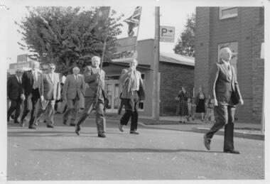
Photograph, RSL ANZAC Day Parade c1990s
R.S.L. march down Hogan Street, ANZAC Day, c1990s.tatura, anzac day, parades, ww2, rsl, costume, male, buildings, historic, flags, national, female, children -
Glen Eira Historical Society
Letter - ELSTERNWICK POST OFFICE
This file contains seven items about the significance of this building and how this was established : 1/ Photocopies of a handwritten application (in duplicate) by Walter Kay of Elsternwick dated 13/10/1985 and Rodney H Bush’s dated 16/10/1985 to the Historic Buildings Council to register the former Elsternwick Post Office building, and an original typewritten letter dated 17/10/1985 from the Historic Buildings Council to Caulfield and Historic Society advising them of an application and inviting them to submit relevant information about the building with a copy of application attached. 2/ Six pieces of correspondence between various interested parties (Caulfield Council , Caulfield Historical Society, National Trust, of Australia and Ministry for Planning and Environment on behalf of Historic Buildings Council, Victoria) about the significance of the former Elsternwick Post Office building and the progress of efforts to include it on the Register of Historic buildings. Dated between November 1985 and May 1986. 3/ Two pieces of correspondence between the Caulfield Progress Association and the Caulfield Historical Society dated April and May 1986, regarding the efforts of the Historical Society to save the former Elsternwick Post Office building. 4/ Two pieces of ephemera by the Caulfield Progress Association, one original undated and one photocopy undated in 1986. Both appealing to the public for support to help the former Elsternwick Post Office building and to protest a proposal to demolish it, by Caulfield Council. 5/Original newspaper article dated 07/06/1989 from the Malvern-Caulfield Progress newspaper written by Robert Carmody. The article talks about the approval by the Historic Buildings Council of Caulfield Council’s restoration program of the former Elsternwick Post Office building worth approximately $850,000. The refurbishment would consist of a shop and office space which would then be rented out. Mayor Emil Braun outlines the progress to implement the plans. 6/ Caulfield Conservation Study by Andrew Ward dated September 1994 of former Elsternwick Post Office Building. The building plans for the Elizabethan Style building were approved in 1891. The original timber verandahs were replaced by the present brickworks in circa 1918 rear extensions in 1941-42. Similar Post Offices were built at Kew, Queenscliff and Portarlington. 7/ Computer printout dated 19/03/2010 of Statement of Significance held by the Victorian Heritage database of the former Elsternwick Post Office Building. It was built in 1891 in the ‘Queen Anne’ style. The substantial two story red brick building was set on a bluestone plinth with an ornate façade incorporating cement dressings. There is a brief summary of the settlement and development of the Elsternwick area with mention of how important the building is to the Elsternwick Community. Original date and author is unknown.elsternwick post office, glenhuntly road, elsternwick, riddell parade, office buildings, postal services, caulfield city council, kay walter, regent street, caulfield, bush rodney h, gisborne street, city of caulfield, braun emil councillor, mayors, aylen doug, aylen douglas r, historic buildings council, caulfield historical society, ministry for planning and environment, head stephen, historic buildings act 1981, anderson p, national trust of australia (victoria), public works department, architectural styles, calder g.k. councillor, wills cathie, lyall kerry, marsden john hudson, town clerk, hill douglas, caulfield progress association, caulfield south, glen eira road, hawthorn road, mac neil j.r., neville street, glenhuntly, marten veronika, ballantyne richard, royal historical society of victoria, dunstan don, alfada street south, hardy joan, baird rob, snowball betty, ward andrew, hoddle robert, foot henry, ebden charles hodson, elster, oldham mary kate, english ‘queen anne’ revival style, rifle club, coulson herbert h., fick p.g., railway, city manager, austin g.b. h., architects, builders, architectural features, australia post, register of historical buildings, grey karen, planning appeal board, heritage overlay no h029, victorian government gazette no. 60 dated 16/07/1986, historic building no640, certificate of title volume 5817, kennan james harley, nelson ivor, blake alison, neale anne, telegraph offices, wardell, ward andrew