Showing 13912 items
matching kiewa-valley
-
 Kiewa Valley Historical Society
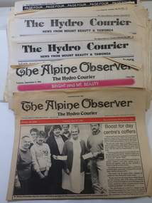
Newspapers - The Hydro Courier 1992 and 1993, News from Mount Beauty & Tawonga
Articles and photos pertaining to the news from the Kiewa ValleyHistoricalPages titled 'The Hydro Courier' taken from 'The Alpine Observer' in 1992 and 1993. The pages focus on news from Mount Beauty & Tawonga. Includes copies of the Towonga Primary School centenary.the hydro courier, kiewa valley news -
 Halls Gap & Grampians Historical Society
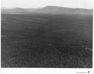
Photograph
Photo depicts Fyans Valley. The road is The Grampians/ Dunkeld Road, leading to Dunkeld towards the right or Halls Gap travelling towards the left. Fyans Creek is visible in parts at the foot of the range (middle of Photo). Photo appears to have been taken from Bellfield Pk area. Photo is typical of those taken by Forests Commission of Victoria in the 1960sPhoto shows a mountain range in the background with a valley. The Valley has a band of a mostly cleared grassy section (middle of photo) with a fairly dense treed area in the foreground. A road and some buildings can be seen where the cleared land meets the treed area.scenery, fyans valley -
 Kiewa Valley Historical Society
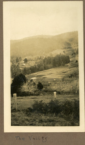
Photographs – Set of 4 black and white photographs. One of a wooden church and three of rural homes and farmland. Area not identified
Europeans arrived in the Kiewa and Ovens Valleys in the 1830's and 40's. Following the drought of 1838-44, seeking out the rich pastures in the fertile Valleys. It proved to be perfect conditions for dairy farming and the raising of cattle. Miners Cottages and other similar wooden structures were a common sight in the area as they were a modest form of accommodation for their period, were quick to erect and economical as they made use of locally available building materials such as local timbers.These photographs provide a snapshot into the early dwellings and architecture of the Kiewa and Ovens Valley regions, including buildings such as the church, which provided an important gathering place for social interaction, especially in these isolated areas.1-Wooden church building with no identification. Large tree in the foreground in front of church 2&3- Black and white photographs of farmland and assorted dwellings, mostly miners style cottages in a valley with mountains in the background. A bridge with wooden railings is visible over the river in the middle of the photograph, also a more modern dwelling is visible in the north east of the photograph close to the river. 4-Black and white photograph of residential homes and farmland with an unsealed road running through the middle. Foreground shows a field which has been semi cleared of trees (stumps remaining). In the background are larger farming properties with the road disappearing into the distant hills. This might be Old Tallangatta before the town was moved in 1956. 1-3 - No inscriptions 4- Signature written on back in lead pencil - Sandra Templebuildings; church; farmland -
 Kiewa Valley Historical Society
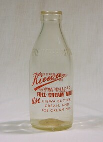
Bottle - Milk, 1959
This is a milk bottle from the local dairy in Kiewa. It is an old style bottle in imperial measure(ended 1974). This has good historical value, as milk is no longer made in bottles and we do not use imperial measurements anymore. This item is significance for historic reasons, shows local dairy items used. There are not many bottles from this local dairy from this period, and is it is in good condition. . Social significance, shows what items local families used. Research significance. These bottles are not in use anymore as we do not have imperial measurement, so good for research that explains this topic. Therefore has good interpretive capacity.Glass milk bottle. One imperial pint.Glass molded inscription of ONE IMPERIAL PINT. In red text on front Kiewa, (in script) / PASTUERISED / FULL CREAM MILK/ USE KIEWA BUTTER/ CREAM / AND ICE CREAM MIX . In red text on back THIS BOTTLE ALWAYS REMAINS/THE PROPERTY OF/NORTH EASTERN/DAIRY CO. LTD. On bottom of bottle, molded AGM 2 x M F1959 in the middle of botton 5 / 48 bottle, milk, drink, container, dairy, farm, kiewa, cow -
 Kiewa Valley Historical Society
Photos - Junction Dam Spillway, Kiewa Hydro Electric Scheme
2 black and white small photos titled - A. 'Bogong Village, Kiewa Hydro Electric Project' and B. 'Junction Dam & Spillway, Lake Guy, Bogong, Kiewa Hydro Electric Project' -
 Kiewa Valley Historical Society
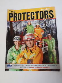
Magazine - The Protectors, A Tribute to the Men and Women who Defended Victoria in Fire Season 2006-07
The magazine covers details of the 2006-07 bushfires in Victoria. On page 31 Region 24 list includes towns in the Kiewa Valley. The Kiewa Valley is under constant threat of bush fires during summer. Local fire brigades assist in the protection of residents.The Kiewa Valley was affected by the 2006-07 bushfires. Residents are encouraged to have a fire plan, to be knowledgeable about bush fires and to be ready to leave their homes when under threat. The local towns each have a fire brigade which includes volunteers. On page 18, 'The Yellow Line" - Photo of Kiewa Valley (Mt Beauty and Tawonga) Crews.Glossy coloured photograph of firemen on the front cover and raging fire on the back cover. 31 pages2006 - 2007 bushfires, kiewa valley fire crews -
 Orbost & District Historical Society
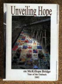
D.V.D, Jenkins, Daniel - Hot Dog Films, Unveiling Hope, 8.8.2002
As part of the Crelebration of the Year of the Outback, McKillop's Bridge in the Deddick Valley was hung with nineteen banners made by individuals and groups of East Gippsland. Banners containing thousands of messages of hope and optimism for the future of rural communities were suspended from he bridge in the Snowy River National Park, in front of a three hundred strong crowd that had assembled. Sister Helen Barnes from the Sisters of St Joseph Order, founded by Mary McKillop, initiated the project. This event was a significant event in local history and this item is a contemporary recording of it.A D.V.D. titled, Unveiling Hope. On the front is a coloured photograph of McKillop's Bridge in the Deddick Valley.mckillop's-bridge banners-of-hope -
 Halls Gap & Grampians Historical Society
Photograph - B/W
Viewing area is known as The Balconies overlooking Victoria Valley. Photo is typical of tourism photos taken by the Victorian Railways during this period. c1950 -60'sa group of people (17) standing on a rocky ledge overlooking a treed valley. a second rock ledge is above them creating the impression of a large mouth. Printed on back: Copyright Photograph. This photograph may be reproduced on condition that it is acknowledged a s 'VICTORIAN RAILWAYS PHOTOGRAPH'. P3465 written faintly in pencil. The Balconies Halls Gap written in blue penscenery, lookouts -
 Falls Creek Historical Society
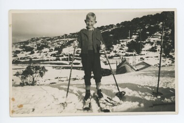
Photograph - John Meyer enjoying the snow, c1949
MEYER COLLECTION - FALLS CREEK PHOTOS In 1947 a determined group of like-minded State Electricity Commission (SEC) staff including Ray Meyer, the chief surveyor of the Kiewa Hydro-Electric Scheme, had a common interest that revolved around the skiing potential of the snow-covered high plains which included what is now the resort of Falls Creek. The six SEC employees, Toni St Elmo, Ray Meyer, Jack Minogue, Lloyd Dunn, Adrian Ruffenacht and Dave Gibson (together with their families) banded together to secretly build a 'hut' that was the first ski lodge at Falls Creek. Using a road built in 1930s to gain access to Falls Creek, their hut project was carried out in secret as efforts by other skiers were blocked by H.H.C. Williams – the engineer in charge of the Hydro Scheme. In 1946 Ray Meyer made a trip to the Lands Office in Melbourne. He came away with a 99-year lease on three acres that was ideally suited for a hut designed by Lloyd Dunn. Adrian Ruffenacht (Design Engineer for the KHS) had suggested where the group should build because of easy access to a spring for water. Much of the building material required was scavenged from derelict huts on the high plains. Due to the need for secrecy, the determined group worked on the hut in the evenings and weekends to avoid detection. During the building period the group had met at Echidna Rock (now known as Eagle Rock) where Skippy St Elmo announced, "This is my favourite ‘Skyline’.” And so the first lodge in the area at Falls Creek Ski Resort came into existence. With the development of the International Poma in the 1970s, the Skyline Lodge, which was sited between the ski-lift’s pole one and pole two, was demolished. However, the legacy of Ray Meyer, Toni St Elmo, Jack Minogue, Lloyd Dunn, Adrian Ruffenacht and Dave Gibson and Skyline lives on in the vibrant atmosphere of Falls Creek Resort. The MEYER COLLECTION documents developments on the Kiewa Hydro Scheme and their life at Falls Creek from the mid 1930s to 1960s.These images are significant because they depict aspects of the life of a pioneering family of Falls Creek and the founders of "Skyline", the first lodge at Falls Creek.Images of John Meyer in the High Plains 1. John Meyer at Rocky Valley, Bogong High Plains. Rocky Valley Camp can be seen in the background. 2. John Meyer near Skyline, Falls Creekfalls creek, victorian snowfields, john meyer, skyline -
 Kiewa Valley Historical Society
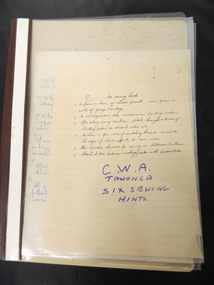
Folder - C.W.A Tawonga, Six Sewing Hints
C.W.A. was a popular organisation in the Kiewa Valley. One of their activities was sewing.The Tawonga branch of the Country Women's Association involved many women in the Kiewa Valley. They sewed to make clothes for their family and for fetes when raising money for schools and churches.Brown plastic with clear front cover with 4 clear sleeves / pages. Includes: Handwritten Sewing Hints.country women's association; sewing; kiewa valley -
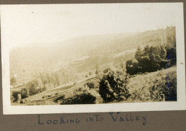 Mt Dandenong & District Historical Society Inc.
Photograph
The photograph is from the album of Ivy Child. The scene is looking across the Kalorama Valley with land cultivated by the Jeeves family. Ivy May Child (1910 – 1989) was the daughter of Arthur Edward (Ted) Child (1878 – 1964) and Ethel May Madden (1888 – 1970). Ted Child was the son of Matthew Francis Child (1839 – 1933) and Martha Jeeves (1857 – 1926). He was the grandson of one of the early pioneers Francis Child. Ivy grew up on the family property on Childs Road and took many photographs. Most of these are glued into her photo album. The album covered the years from c1927 – 1932. Ivy married Henry William Burgess (1906 – 1968) in 1944. The photographs remain in their original state in the album with individual copies made. Black and white photograph with bushes in the foreground, hills in the distance and a cleared, cultivated area in the centre.Below the photograph in the album" LOOKING INTO THE VALLEYkalorama, kalorama valley, jeeves, valley -
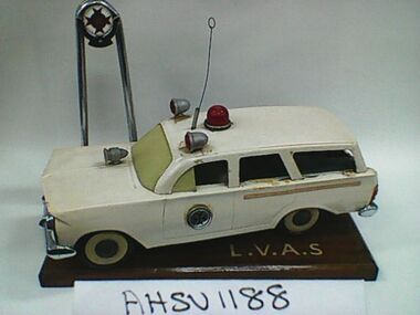 Ambulance Victoria Museum
Model, Ambulance, Holden Station Wagon, Frank Dean, Morwell Panel Works, 28 August 1966
Presented to Latrobe Valley & District Ambulance Service By Frank Dean Morwell Panel Works 26 August 1966. At one time, this model was located on the board room desk of the Latrobe Valley District Ambulance Service (refer to photograph inside AHSV1343)Pressed tin station wagon model on timber base with Ambulance Service Victoria logo mounted on poles behind car. Car has flashing lights, electrical mechanism inside car and on/off switch on right hand back doorPresented to Latrobe Valley & District Ambulance Service By Frank Dean Morwell Panel Works 26-8-66 latrobe valley ambulance service -
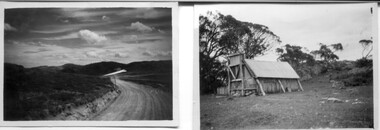
 Kiewa Valley Historical Society
Photos - A. Dartmouth Dam B.-E. Kiewa Valley
A. x3 colored photos of Dartmouth Dam during construction B. x5 black & white photos of Falls Creek and Kiewa Valley C. x7 black & white photos of groups of people D. x5 black & white photos and 3 colored photos of people in clubs E, x1 black & white photo -
 Kiewa Valley Historical Society
Papers - The Tobacco Industry
Tobacco in the Kiewa Valley. Tobacco was grown in Victoria for many years but the main areas (from the 1960s) included the Upper Kiewa River Valley where areas were suited. A Tobacco Research Station was established in Myrtleford, the geographical centre of the North Eastern tobacco growing area.Tobacco was grown successfully in the Kiewa Valley1. Leaflets x2 Green paper - 'The Tobacco Plant' Prepared by The Tobacco Growers of Victoira Limited in consultation with the Dept. of Agriculture Tobacco Research Station, Ovens. 1980s 2. papers yellowed and printed on both sides. - 'The Golden Leaf - The story of the tobacco leaf. Prepared by the Tobacco Growers of Victoria Ltd.' 1980stobacco, kiewa valley, agricultural farming -
 Mt Dandenong & District Historical Society Inc.
Photograph
The photograph is from the album of Ivy May Child. The scene is looking down across the Kalorama Valley in the early 1930s. Probably across the Jeeves and Child properties. Ivy May Child (1910 – 1989) was the daughter of Arthur Edward (Ted) Child (1878 – 1964) and Ethel May Madden (1888 – 1970). Ted Child was the son of Matthew Francis Child (1839 – 1933) and Martha Jeeves (1857 – 1926). He was the grandson of one of the early pioneers Francis Child. Ivy grew up on the family property on Childs Road and took many photographs. Most of these are glued into her photo album. The album covered the years from c1927 – 1932. Ivy married Henry William Burgess (1906 – 1968) in 1944. The photographs remain in their original state in the album with individual copies made. Black and white photograph with a post and wire fence in the foreground , hills in the distance and a cultivated area in the centre.Written below the photograph in the album: The Valleyjeeves, child, kalorama valley, kalorama, valley -
 Kiewa Valley Historical Society
18 small black and white photographs of the Bogong High Plains, 1948
These photos of the Bogong High Plains were all taken by Ronald George Thorn who was a cadet engineer with the State Electricity Commission. He worked on the Kiewa scheme from 1948 to 1950 doing overhead line construction and maintenance plus electrical design and drawing work. They are from his personal collection and a record of his time in the Kiewa area.Pictorial history of personal involvement in the the early days of the Kiewa Scheme.18 small black and white photographs all taken on the Bogong High Plains.Photo 1 Wallace's Hut. Photo 2 Ruined Castle - Looking towards Pretty Valley December 1948. Photo 3 Ruined Castle - Looking towards Pretty Valley December 1948. Photo 4 Ruined Castle - Looking Down Valley December 1948. Photo 5 - Mt. McKay from Ruined Castle October 1948. Photo 6 View from Rocky Valley Camp October 1948. Photo 7 Mt. Feather Top from Ruined Castle October 1948. Photo 8 View from Ruined Castle looking downwards towards Beauty October 1948. Photo 9 Rocky River from gauging station October 1948. Photo 10 Rocky Valley River from main road October 1948. Photo 11 View along little Arthur Fire Track October 1948. Photo 12 View along main road. Looking towards Beauty Valley October 1948. Photo 13 View from Little Arthur Fire Track October 1948. Photo 14 Frying Pan Spur from Rocky Valley Road October 1948. Photo 15 Mt. Bogong from Big Hill Fire Track October 1948. Photo 16 View from Big Hill Fire Track October 1948. Photo 17 Mt. Feathertop from Ruined Castle October 1948. Photo 18 Mt. Fainter from Ruined Castle October 1948. (All of the above is hand written on the back of photos in ink). bogong high plains; r g thorn; secv; kiewa hydro electric scheme; pictorial history -
 Kiewa Valley Historical Society
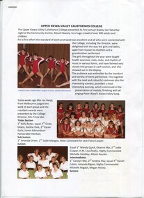
Papers - x6 The History of the Upper Kiewa Valley Calisthenics College
The Upper Kiewa Valley Calisthenics College was popular during the 1980s and 1990sCalisthenics was a source of exercising, socialising and competing during leisure time while living in the Kiewa Valley. This activity is of historic and social significance and can be compared with activities of today and in the past.Two pages with coloured photos refer to "The History of the UKV Calisthenics College"; x1 blue page advertising the 1983 Annual Display and x5 pages back to back re 1990 Concert including program and names of performers.ukv calisthenics, entertainment -
 Kiewa Valley Historical Society
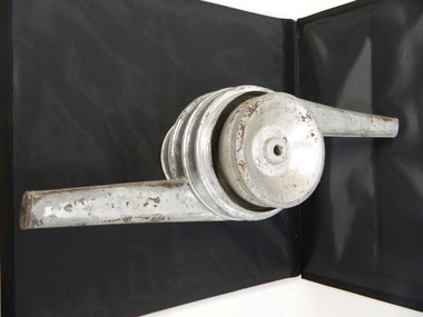
Cream Separator - part of
The Kiewa Valley is a farming district with dairy farms predominating for many years. Painted silver steel cone with a hollow cylinder running through it. This piece fits into larger piece that consists of 3 parts all joined and with a hollow cylinder running through it. The top part has a hollow handle coming out on one side, the middle piece has a hollow handle coming out on the opposite side and the bottom part is a wide hollow cylinder. dairy. farm. kiewa valley. cream. milk. separator. -
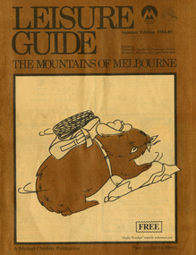 Marysville & District Historical Society
Magazine (Item) - Leisure guide, Michael Cheshire, LEISURE GUIDE THE MOUNTAINS OF MELBOURNE, 1984
A leisure guide to the mountains of Melbourne beginning in the eastern suburbs, going through the Yarra Valley and into the Great Dividing Range. This was produced by Michael Cheshire as a free publication to promote Melbourne tourism. The magazine featured Healesville, Marysville, Warburton, Eildon, Alexandra, the Upper Yarra area, and includes information on wineries in the district. It was released in the summer of 1984-1985.A leisure guide to the mountains of Melbourne beginning in the eastern suburbs, going through the Yarra Valley and into the Great Dividing Range.Summer Edition 1984-85 Featuring:/ Healesville, Marysville, Warburton, Eildon,/ Alexandra, Wineries and Upper Yarra Area.healesville, warburton, eildon, alexandra, upper yarra, marysville, victoria, australia, leisure guide, michael cheshire, blackwood holiday flats, black spur motel and caravan park, tudor lodge road house, nanda binya lodge, marysville caravan park, marysville recreation and fun park, scenic motel, the tower motel, the cumberland, cathedral restaurant, cathedral restaurant gallery, taggerty golf course, taggerty holiday units, marylyn guest house -
 Kiewa Valley Historical Society
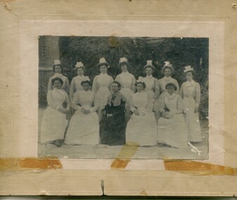
Photographs – Group of 3 old sepia photographs, 2 of women in period costume and 1 of group of nurses from Sunbury sanatorium
Europeans arrived in the Kiewa Valley in the 1830s and 40s. Following the drought of 1838-44 seeking out the rich pastures in the fertile Kiewa Valley. . The next major increase in population was as a result of the Kiewa Hydro Scheme. The beginning of construction of the Kiewa Hydro-electric scheme in the late 1940s introduced changes and led to the enlargement and improvement of local roads and the townships of Mount Beauty and Bogong Village were constructed by the SECV from the 1930’s to the 1950’s to house workers on the Kiewa Hydro Electric Scheme. At its peak the Kiewa Scheme employed around 4000 people from all walks of life and as many cultures.The influx of European migrants to work on the Hydro Scheme along with their rich cultural backgrounds, all played a major part in establishing the history of the area and in shaping the future character of the Mount Beauty, the Kiewa Valley and Falls Creek areas. Photographs may depict descendants, family or friends of early settlers or workers in the Kiewa Valley region.1. Sepia photograph, mounted on heavy buff card with yellowing marks from sticking tape across the bottom of the photograph. Photograph is of a group of nurses taken at the Sunbury Sanitorium 2. Sepia photograph mounted on heavy buff card with yellowing marks from sticking tape at top and bottom of photo. Mark from drawing pin in centre top of photo. Photograph is of a middle aged woman posing dressed in period costume 3. Sepia photograph mounted on heavy buff card with yellowing marks from sticking tape at top and bottom of photo. Mark from drawing pin in centre top of photo. Photograph is of an older woman posing dressed in period costume sepia photos; nurses; kiewa valley; sunbury sanitorium; period costume -
 Halls Gap & Grampians Historical Society
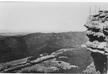
Photograph - B/W, C 1950s (?)
Photograph is of Fyans Valley taken from Bellfield Peak. The mountain range across the centre of the scene runs north to south. The large dwelling centre-front is Bellfield Hotel, which was destroyed by fire in the 1960s. The main road running through the middle of the valley is Grampians Road.A rocky outcrop, far right, with metal fence and posts. View of a valley with cleared land, roads and buildings in foreground. Further cleared land can be seen beyond a mountain range that is in the centre of the photograph.scenery, fyans valley -
 Kiewa Valley Historical Society
DVDs - Miscellaneous and 2 tapes
Tapes and DVDs collected and stored. KVHS members have not the means to play them.1. Small tape - Rob Hollonds 14th Jan. 1985 2. Tape: Mandy Driver - Interview with Wilma Davies 3. Two KVHS DVDs for display: Photos The Dairy Industry: Milk Bottle and Milking 4. KVHS Strategic Plan 2012-2014 5. SEC Kiewa History - Back Up 6. Back Up Kiewa Hydro: - Kiewa, Kiewa in the Making, Pure Power 7. Back Up: Kiewa in the Making, Kiewa Capers, It only seems like Yesterday, Kiewa 8. ?? Section 2, Posters 1.2.3.4 9. ?? Sections 3, Posters 2.3.4 10. Ref 74982 KVHS - HKV Files 11. Ref. 74982 KVH - HKV Files 12. Michael Vorfeld DVD (BCS) 0424095554 'Kiesa' 13. The Savoy Ladies Group - Myrtleford Italian group 14.x2 DVDs by Philip Samartzis - "Current" with explanation leaflet. (Bogong Sound) tapes and dvds, wilma davies interview, kvhs strategic plan, display on milking -
 Kiewa Valley Historical Society
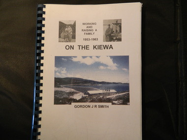
Book - On the Kiewa, Working & Raising a Family 1953 - 1963 by Gordon J. R. Smith, 9th September 2005
Personal account of Gordon Smith's life when living in Mt Beauty and Bogong townships while working for the SECV on the Kiewa Hydro Electric Scheme.Gordon gives an account of both working and living during the 1950s and early 1960s in a remote part of Victoria - the Kiewa Valley and in 2 small construction towns. He gives a lot of detail eg. the weather, his work, the people, the activities, his family and leisure time.Plastic threaded spine holding 282 pages with black and white photos. Front Cover includes 2 small black and white photos either side of the title at the top and below the title a larger colored photo of Rocky Valley Dam. Author's name is underneath. "Dick Puttyfoot" on cover page.kiewa hydro electric scheme, state electricity commission of victoria., gordon smith -
 Halls Gap & Grampians Historical Society
Photograph - B/W
Photo is of Victoria Valley with Moora Moora Reservoir and the Victoria Range in the background. Photo would have been taken from around Reed's lookout area. Photo typical of promotional photos of the time by Forests CommissionLarge, densely treed valley with a body of water in background. Some roads can be seen particularly right foreground. There is a mountain range in the background. c1960sscenery, grampians ranges -
 Kiewa Valley Historical Society
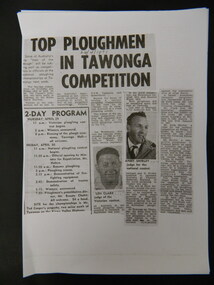
Papers - Collection of newspaper articles re Kiewa Valley, 1970's
Newspaper articles describing incidents/news of the Kiewa Valley during the 1970's.Each article is significant because it is connected to people and places in the Kiewa Valley.9 photocopies of newspaper articles: 1. Fire at Mt Beauty Workmen's club 2. Ploughing Championship at Tawonga 24 Apr. 1971 3 & 4. Charles Derrick's 10 year anniversary of his death on Mt Hotham 5 Sept. 1975 5. Alps to be a National Park 15 July 1978 6. Tawonga Exchange to go Automatic 20 June 1974 7 & 8. Winter Playground 9. Alps National Parknewspaper articles; kiewa valley; news of the 1970s; -
 Kiewa Valley Historical Society
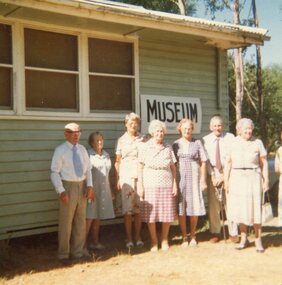
Photograph of local residents at Tawonga Caravan Park Museum Building, 11th February, 1979
Pictorial record of residents of the Kiewa Valley in the late 1970's and early buildings Pictorial record of residents of the Kiewa Valley in the late 1970's Colour photograph of local residents standing outside the Museum building at Tawonga Caravan ParkHandwritten on back of photograph in blue ink: Q Baldwin, C Joung, Gwen Hobbs, Mrs Van De Wyde, T & M Wallace and Mrs Temple. Taken by C Roper on 11th February, 1979tawonga caravan park, kvhs members, kiewa valley -
 Kiewa Valley Historical Society
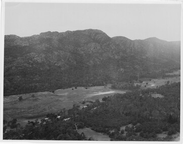
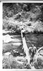
3 small black and white photos of West Kiewa River and Tail Race, c1948/49
The No. 4 Tail Race Tunnel was commenced in 1947 from the downstream end at Mt. Beauty. Difficulties were encountered and driving from the top end in a downstream direction was commenced in January 1950 and the breakthrough between these two headings occurred on 22d July.Historical record of the construction of the Kiewa Hydro Electric Scheme.3 small black and white photographsPhoto 1 - on back in ink - 'Tour of area, crossing West Kiewa Branch Jan. 1949 Photo 2 - on back in ink - 'Kiewa Valley River - site of tunnel in rear. Dec. 1948'. Photo 3 - on back in ink - 'No. 4 Tail Race Portal Mt. Beauty Jan. 1949'.west kiewa river; tail race portal; mt beauty; kiewa hydro electric scheme -
 Kiewa Valley Historical Society
Photograph - Bogong Village (7 copies), Approx 1940
In 1940 Field Headquarters for the Kiewa Scheme were established at Bogong with office, workshop facilities and accommodation for workmen, staff and some families constructed. (There had been a 'tent camp' on this site in 1939 but was destroyed by bushfires) Construction of accommodation continued until 1947. A total of 40 houses plus a hostel for single staff, post office, police station, medical centre and primary school all with water and sewerage and electricity supply. The staff hostel was known as Kiewa House and is now occupied by the Education Department. Lake Guy was named after Mr. L.T. Guy who was the Resident Engineer in charge of construction work and associated activities on the Kiewa area. He held this position from 1939 to November 1946 when he was transferred to Head Office. The Bogong Township was developed firstly as an accommodation centre (base camp) for construction workers employed under the Kiewa Hydroelectric Scheme. Due to the influx of European workers into the Township the beautification of the immediate surrounds (gardens etc.) had a distinct European flavour. This environment has been very beneficial for tourism in later years. At the completion of the scheme, in the 1960's, the village was opened to public/tourism use. Strict environmental control has not allowed for any extensive redevelopment in tourist accommodation and basically restricted it to the accommodation initially built for the construction workers. Activities such a bike riding, snow skiing, restricted horse riding and bush walking on the Alpine plains and mountains are now a viable part of the Kiewa Valley Tourist Industry. The lake is one of the many water storage reservoirs used to supply the power stations their main power to run the huge turbines generating the final product, electricity. Evidence can be seen of the 1939 bushfires.Set of 7 identical black and white photographs of Bogong Village after 1939 bush firesHandwritten on the back of one photo - Bogong Village approx. 1940, after 1939 bush fires. Staff residences to left. Kiewa House, General offices and test lab to the right. Hand drawn map on the back of one photo.bogong village, secv -
 Falls Creek Historical Society
Document - The F.C.T.A. (Amendment) Regulations 1961
Bob Hymans Collection Bob (Herman) Hymans (a former member of the Royal Netherlands Navy) was born in Bloemendaal, Holland on 30th September 1922. During World War II he fought against the Japanese in the Dutch East Indies (now Indonesia) and was imprisoned in Changi and on the Burma Railway. After gaining qualifications as a Ski Instructor, Bob arrived in Falls Creek in July 1950. Working as an Instructor and Supervisor at Bogong Lodge, Bob decided his future was in accommodation. He was successful in negotiating an indenture for land from the State Electricity Commission (SEC). It took Bob two years to build his Grand Coeur Chalet but, tragically, it was burned down in August 1961. Bob also built the first Chairlift in Australia. This was a single chairlift and the structure was built from wooden electricity poles. He was constantly full of new ideas and proposals for the village. Bob Hymans die on 7th July 2007. This Collection of documents and letters tells the story of Bob's endeavours to develop Falls Creek into the ski village it is today.This letter is significant because it documents the procedures followed by the Management Committee and amendments made to its area of jurisdiction in 1961.A document outlining amendments made in 1960 to the previous Falls Creek Tourist Area Regulations on 1959. This included extension of the geographic area covered to include the Downhill Racing Course and vehicle parking areas adjoining the Upper Kiewa Valley Road. It also amended the dates for the term of office by members and introduced a system of postal nominations and voting.falls creek tourist area management committee, sec supply to falls creek 1961. -
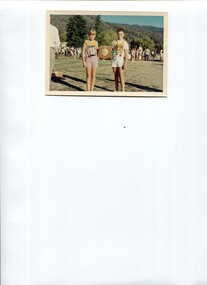 Kiewa Valley Historical Society
Photo - Coloured photo of Upper Kiewa Valley Sports Day
The schools in the Upper Kiewa Valley met annually for a combined athletics sports day. See: "Kiewa Kids" by Graham Gardner and "Below Bogong - A History of Mt Beauty" compiled by Di EdmondsonThere were several schools in the Upper Kiewa Valley that competed in athletics. This activity is of historic and social significance and can be compared with activities of today especially in relation to the number and size of participating schools.Coloured photo of a girl and boy holding a shield with other students in the back ground.upper kiewa valley schools, athletics sports day