Showing 6992 items matching "historic"
-
 St Kilda Historical Society
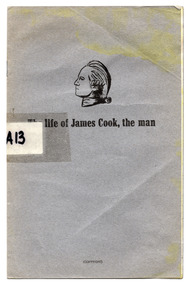
Booklet, Boyes, Rosemary, The life of James Cook, the man, 1970
'Extracts from the Bi-Centenary Presentation in 1970. An illustrated address presented by Mrs. Boyes at Albury and Wagga, New South Wales, Wodonga, Wangaratta, Benalla and Mornington Peninsula, Victoria, to the general public and schools. This Documentary was generously accepted by His Excellency, the Governor of New South Wales, also awarded the New South Wales Government Bi-Centenary Committee's Certificate of Honour. The manuscript of James Cook, the Man, has been placed in the archives of the Greenwich Maritime Museum, London, the largest of its kind in the British Commonwealth, the Captain Cook Landing Place Historic Museum, Kurnell, Botany Bay, Australia, the Newport Historic Marine Museum, Rhode Island, U.S.A., Newport being the last resting place of Cook's "Endeavour".'Cover of grey paper, folded, containing a single folded sheet of white paper, printed in black. Bound with 2 staples. captain cook -
 Warrnambool and District Historical Society Inc.
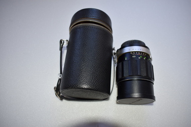
Camera Lens, 1 Soligor Lens. .2 case, C 1960
A manual detachable camera lens is used to focus the subject of which the photograph is to be taken . They have adjustments for distance and clarity while more complex ones can be fine tuned to a much greater degree. Photographs provide a invaluable resource from an historic perspective of past times people and events.This lens has significance as part of the continuum of camera development and use. It was owned by a local Warrnambool person who had a keen interest in photography..1 Black plastic and metal detachable camera lens with metal sections and graduated markings around the cylinder . There is a screw cap on one end where the lens is attached to the camera for use and the other end covering the lens itself has the brand name across the middle of cap. .2 Black leather cylindrical case with strap handle attached with silver metal hiinge and metal zipper towards the top section of the case. The lidded section has the brand name imprinted into the surface of the top..1 Lens made in Japan. Graduated scale from 1.5/5 to 20/50 .2 Soligor camera lens, warrnambool, history of warrnambool, soligor lens -
 Eltham District Historical Society Inc
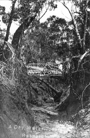
Negative - Photograph, Tom Prior, A Dry Water-course - Research, Vic, c.1895
This water course starts at Mount Pleasant Road, Research. Part of a slide show presentation "Bridges & Waterways of the Shire" by Russell Yeoman to the 13 September 1989 Society meeting. The presentation included slides of historic photos from the Shire of Eltham Pioneers collections as well as several recent views.This photo forms part of a collection of photographs gathered by the Shire of Eltham for their centenary project book,"Pioneers and Painters: 100 years of the Shire of Eltham" by Alan Marshall (1971). The collection of over 500 images is held in partnership between Eltham District Historical Society and Yarra Plenty Regional Library (Eltham Library) and is now formally known as the 'The Shire of Eltham Pioneers Photograph Collection.' It is significant in being the first community sourced collection representing the places and people of the Shire's first one hundred years. The Reynolds family were early settlers in Research. The Reynolds/ Prior collection of photographs were taken by Tom Prior, the maternal uncle of Ivy Reynolds, around 1900 and the 60 photos in the album give a fine overview of many of the landmarks of Research and Eltham over 100 years ago. lvy lived in the family home for many years at 106 Thompson Cres Research. Ivy's father, Ernst Richard Reynolds and grandfather, Richard Reynolds, lived at the same address. Ivy's father Richard worked for Mr. Trail on his property in Research. Reynolds Road is named after the family. Mr Tom Prior (wife Eva) worked at the Melbourne zoo. He was very innovative and made his own camera, using the black cloth hood to exclude the light. The photographs are a reminder of the rural nature of Research and Eltham and its rich heritage.Digital image 4 x 5 inch B&W Negshire of eltham pioneers photograph collection, research (vic.), creek, mount pleasant road, reynolds prior collection -
 Essendon Football Club
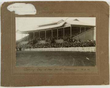
New grandstand
Essendon arrived at the Essendon Recreation Reserve (later known as Windy Hill) in 1922. In August that year the club opened its first grandstand before the round 14 game against Richmond. It was later named the Dick Reynolds Stand.This historic photograph shows supporters crammed into the grandstand that day.Black and white photograph on brown cardboard mount with imprinted border; remains of a white sticker in upper left corner. "E. Franklin Moonee Ponds 37 6794" hand-written in blue biro on reverse."Opening day of new stand, Essendon 19.8.22" -
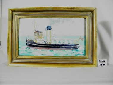 Bay Steamers Maritime Museum
Framed Painting, S. T. Wattle, 1998
This is an oil painting of the Steam Tug Wattle after conversion to a passenger carrying vessel. She was a popular tourist outing for people in the Port Philip Bay area. This painting shows that Wattle was appreciated as a historic vessel, a fun mode of transportation and that there was some appeal to seeing images in her likeness such as this painting.Oil painting of the Steam Tug Wattle after conversion to a passenger-carrying vessel.The port side of the ship is shown in an open water landscape, and is moving towards the left hand edge of the frame The painting is signed in the bottom right hand corner " '98 David Carden"oil painting, passenger vessel, tourists, wattle, painting, bay steamers maritime museum, port phillip bay -
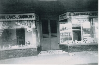 Rutherglen Historical Society
Image, c April 1958
Booklet - Rutherglen heritage walk : a self-guided tour of Rutherglen's Historic Streetscapes / by Rutherglen Wine Experience. 2009, p. 5 - states that the Red Boot Shop was "demolished sometime after WWII, and no trace remained until a wild storm uncovered the tiled entrance in the mid 2000's."Black and white photograph of the front of a café, with a central door flanked by two display windows. In tile, in front of the door, is the sign "The Red Boot Shop".On back of photo: "Ozone Café Main St Rutherglen | approx. April 1958 | purchased by Harold Hall March 1958 from McKinlays. | owners after H. Hall | McCarthy | Alan Zotti"main street rutherglen, red boot shop, ozone cafe, harold hall, alan zotti, mccarthy -
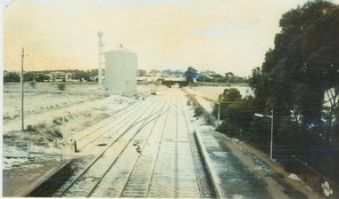 Sunbury Family History and Heritage Society Inc.
Photograph, 25th July 1986
Heavy snow fell across Melbourne and surrounding suburbs, including Sunbury, on 25th July 1985. The photograph taken from the pedestrian bridge at Sunbury Railway Station is looking north to the historic Macedon Street bridge. The widespread snow across the metropolitan area on that day caused much chaos.A coloured photograph of widespread snow across a railway line and the surrounding area.sunbury railway station, extreme weather events, snow storms -
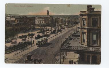 Emerald Museum & Nobelius Heritage Park
Postcard - Postcard of Sturt St, Ballarat, 1890s
This postcard is part of an album of postcards which date from late 19th century to mid 20th century. It depicts Sturt St Ballarat c1890-1900s. The wide boulevard and historic buildings are indicative of the wealth which was brought to Ballarat as a result of the gold rushes in the second half of the 19th century.This postcard is in an album of postcards dating from the late 19th century to mid 20th century. It reflects the popularity of collecting postcards in Australia which reached a height in the early 1900s until around 1920. Postcard of Sturt St, Ballarat - coloured. On front, printed: 'Sturt St Ballarat' On back handwritten: 'My dear Mrs / Brown I write / these few lines ... absent freind [sic friend] / J Drubar'postcard, photography, 1900s, ballarat, "green postcard album" -
 Eltham District Historical Society Inc
Audio - Audio Recording, Mark Cauchi; Eltham to Hurstbridge Railway – The line through the valley of the Diamond, 22 Apr 2022
At this meeting we are pleased to have as our guest speaker Mark Cauchi, who is an active railway historian and a long-term member of the former Australian Railway Historical Society. Mark will provide a glimpse into the extension of the railway from Eltham to Hurstbridge, using various historic and current-day railway images.1:18:42 duration Digital MP3 file; 27.0 MBaudio recording, eltham, eltham district historical society, meeting, society meeting, agm, hurstbridge line, mark cauchi, railway line -
 Marysville & District Historical Society
Photograph (Item) - Colour photograph, Unknown
A colour photograph of The Crossways in Marysville. The Crossways was built in the early 1920s and is the oldest building in Marysville. The Crossways historic inn survived the 2009 Black Saturday bushfires thanks to the efforts of its c-owner Greg Cherry and, in the days after the fires, provided a much-needed refuge to the Marysville community and firefighters. A colour photograph of The Crossways in Marysville.marysville, victoria, australia, photograph, the crossways cabaret, the crossways, crossways, crossways country inn, crossways historic inn, 2009 black saturday bushfires, accommodation -
 Marysville & District Historical Society
Photograph (Item) - Colour photograph, Unknown
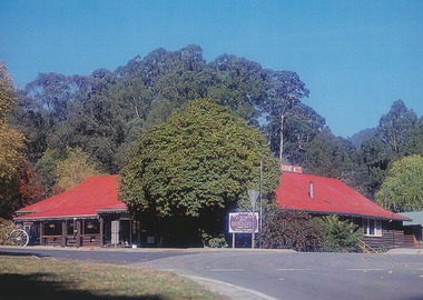
A colour photograph of The Crossways in Marysville. The Crossways was built in the early 1920s and is the oldest building in Marysville. The Crossways historic inn survived the 2009 Black Saturday bushfires thanks to the efforts of its c-owner Greg Cherry and, in the days after the fires, provided a much-needed refuge to the Marysville community and firefighters. A colour photograph of The Crossways in Marysville.marysville, victoria, australia, photograph, the crossways cabaret, the crossways, crossways, crossways country inn, crossways historic inn, 2009 black saturday bushfires, accommodation -
 Phillip Island and District Historical Society Inc.
Photograph, 1978/9
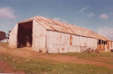
The big Hayshed was built by J. D. McHaffie on his property at Ventnor. He used timber washed up by the sea and roofing iron from the dome of the Exhibition Building in London. After purchasing the historic McHaffie homestead, Mr Harbison removed most of the buildings to Innishowen. It was still standing in 1977."Innishowen". Coloured photograph of large galvanised iron haystack, rusted with age. Part of timber frame visible at right hand side. Training Jinker shown against the side of shed.local history, photographs, buildings - historical, coloured photograph, john cook, innishowen, ventnor, phillip island -
 Eltham District Historical Society Inc
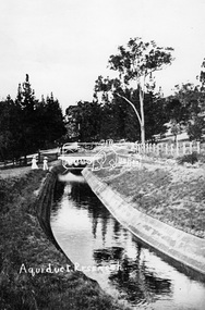
Photograph, Tom Prior, Maroondah Aqueduct, Research, Vic, c.1895
Built for opening in 1891 to take water from Maroondah to Reservoir. Part of a slide show presentation "Bridges & Waterways of the Shire" by Russell Yeoman to the 13 September 1989 Society meeting. The presentation included slides of historic photos from the Shire of Eltham Pioneers collections as well as several recent views.This photo forms part of a collection of photographs gathered by the Shire of Eltham for their centenary project book,"Pioneers and Painters: 100 years of the Shire of Eltham" by Alan Marshall (1971). The collection of over 500 images is held in partnership between Eltham District Historical Society and Yarra Plenty Regional Library (Eltham Library) and is now formally known as the 'The Shire of Eltham Pioneers Photograph Collection.' It is significant in being the first community sourced collection representing the places and people of the Shire's first one hundred years. The Reynolds family were early settlers in Research. The Reynolds/ Prior collection of photographs were taken by Tom Prior, the maternal uncle of Ivy Reynolds, around 1900 and the 60 photos in the album give a fine overview of many of the landmarks of Research and Eltham over 100 years ago. lvy lived in the family home for many years at 106 Thompson Cres Research. Ivy's father, Ernst Richard Reynolds and grandfather, Richard Reynolds, lived at the same address. Ivy's father Richard worked for Mr. Trail on his property in Research. Reynolds Road is named after the family. Mr Tom Prior (wife Eva) worked at the Melbourne zoo. He was very innovative and made his own camera, using the black cloth hood to exclude the light. The photographs are a reminder of the rural nature of Research and Eltham and its rich heritage.Digital image (Neg copy missing)shire of eltham pioneers photograph collection, research (vic.), maroondah aqueduct, aqueduct, reynolds prior collection -
 St Kilda Historical Society
Photograph - Photo map, 28/01/1951
One of a series of photo-maps produced for the Department of Crown Lands and Survey (1857-1983). For correlation with a current map, and access to other historical photo maps of Victoria, see the Historic Photo-Maps Index published by the Department of Environment, Land, Water and Planning at https://services.land.vic.gov.au/DELWPmaps/historical-photomaps/Black and white aerial photograph1424-45 SECRET 534 Run 18 Lens 12" Melbourne Metropolitan 12150 28.1.51 M639albert park, st kilda junction, st kilda pier, catani gardens, st kilda, prahran, albert park lake, 1951, middle park, st kilda beach, windsor -
 St Kilda Historical Society
Photograph - Photo map, 17/01/1951
One of a series of photo-maps produced for the Department of Crown Lands and Survey (1857-1983). For correlation with a current map, and access to other historical photo maps of Victoria, see the Historic Photo-Maps Index published by the Department of Environment, Land, Water and Planning at https://services.land.vic.gov.au/DELWPmaps/historical-photomaps/Black and white aerial photograph1414-21 538 Run 19 Lens 12" Melbourne Metropolitan 12150 17.1.51 M586st kilda, st kilda botanical gardens, peanut farm, elwood, 1951, point ormond, elwood canal, st kilda beach -
 St Kilda Historical Society
Photograph - Photo map, 28/01/1951
One of a series of photo-maps produced for the Department of Crown Lands and Survey (1857-1983). For correlation with a current map, and access to other historical photo maps of Victoria, see the Historic Photo-Maps Index published by the Department of Environment, Land, Water and Planning at https://services.land.vic.gov.au/DELWPmaps/historical-photomaps/Black and white aerial photograph1424-118 534 Run 20 Lens 12" Melbourne Metropolitan 12150 18.1.51M639elwood, point ormond, elwood park, elsternwick park, elwood beach, 1951 -
 St Kilda Historical Society
Photograph - Photo map, 17/01/1951
One of a series of photo-maps produced for the Department of Crown Lands and Survey (1857-1983). For correlation with a current map, and access to other historical photo maps of Victoria, see the Historic Photo-Maps Index published by the Department of Environment, Land, Water and Planning at https://services.land.vic.gov.au/DELWPmaps/historical-photomaps/Black and white aerial photograph1414-20 538 Run 19 Lens 12" Melbourne Metropolitan 12150 17.1.51 M586elwood, elsternwick, st kilda east, balaclava, ripponlea, 1951 -
 St Kilda Historical Society
Photograph - Photo map, 28/01/1951
One of a series of photo-maps produced for the Department of Crown Lands and Survey (1857-1983). For correlation with a current map, and access to other historical photo maps of Victoria, see the Historic Photo-Maps Index published by the Department of Environment, Land, Water and Planning at https://services.land.vic.gov.au/DELWPmaps/historical-photomaps/Black and white aerial photograph1424-44 534 Run 18 Lens 12" Melbourne Metropolitan 12150 28.1.51 M639 -
 St Kilda Historical Society
Photograph - Photo map, 28/01/1951
One of a series of photo-maps produced for the Department of Crown Lands and Survey (1857-1983). For correlation with a current map, and access to other historical photo maps of Victoria, see the Historic Photo-Maps Index published by the Department of Environment, Land, Water and Planning at https://services.land.vic.gov.au/DELWPmaps/historical-photomaps/Black and white aerial photograph1424-43 534 Run 18 Lens 12" Melbourne Metropolitan 12150 28.1.51 M639armadale, malvern, st kilda cemetery, caulfield north, st kilda east, 1951 -
 St Kilda Historical Society
Photograph - Photo map, 30/01/1960
One of a series of photo-maps produced for the Department of Crown Lands and Survey (1857-1983). For correlation with a current map, and access to other historical photo maps of Victoria, see the Historic Photo-Maps Index published by the Department of Environment, Land, Water and Planning at https://services.land.vic.gov.au/DELWPmaps/historical-photomaps/Black and white aerial photographVic 1093-62 Melbourne & Metropolitan Project Run 21 30.1.60 Lens 10" 8.200middle park, albert park, catani gardens, st kilda west, 1960 -
 St Kilda Historical Society
Photograph - Photo map, 30/01/1960
One of a series of photo-maps produced for the Department of Crown Lands and Survey (1857-1983). For correlation with a current map, and access to other historical photo maps of Victoria, see the Historic Photo-Maps Index published by the Department of Environment, Land, Water and Planning at https://services.land.vic.gov.au/DELWPmaps/historical-photomaps/Black and white aerial photographVic 1093-60 Melbourne & Metropolitan Project Run 21 30.1.60 Lens 10" 8.200st kilda, albert park, prahran, windsor, south yarra, 1960 -
 St Kilda Historical Society
Photograph - Photo map, 30/01/1960
One of a series of photo-maps produced for the Department of Crown Lands and Survey (1857-1983). For correlation with a current map, and access to other historical photo maps of Victoria, see the Historic Photo-Maps Index published by the Department of Environment, Land, Water and Planning at https://services.land.vic.gov.au/DELWPmaps/historical-photomaps/Black and white aerial photographVic 1092-36 Melbourne & Metropolitan Project Run 22 30.1.60 Lens 10" 8.200st kilda, st kilda pier, st kilda beach, catani gardens, 1960 -
 St Kilda Historical Society
Photograph - Photo map, 30/01/1960
One of a series of photo-maps produced for the Department of Crown Lands and Survey (1857-1983). For correlation with a current map, and access to other historical photo maps of Victoria, see the Historic Photo-Maps Index published by the Department of Environment, Land, Water and Planning at https://services.land.vic.gov.au/DELWPmaps/historical-photomaps/Black and white aerial photographVic 1092-38 Melbourne & Metropolitan Project Run 22 30.1.60 Lens 10" 8.200st kilda, st kilda beach, st kilda pier, catani gardens, 1960, st kilda botanical gardens, peanut farm -
 St Kilda Historical Society
Photograph - Photo map, 30/01/1960
One of a series of photo-maps produced for the Department of Crown Lands and Survey (1857-1983). For correlation with a current map, and access to other historical photo maps of Victoria, see the Historic Photo-Maps Index published by the Department of Environment, Land, Water and Planning at https://services.land.vic.gov.au/DELWPmaps/historical-photomaps/Black and white aerial photographVic 1092-40 Melbourne & Metropolitan Project Run 22 30.1.60 Lens 10" 8.200st kilda east, balaclava, ripponlea, st kilda cemetery, 1960 -
 St Kilda Historical Society
Photograph - Photo map, 30/01/1960
One of a series of photo-maps produced for the Department of Crown Lands and Survey (1857-1983). For correlation with a current map, and access to other historical photo maps of Victoria, see the Historic Photo-Maps Index published by the Department of Environment, Land, Water and Planning at https://services.land.vic.gov.au/DELWPmaps/historical-photomaps/Black and white aerial photographVic 1092-42 Melbourne & Metropolitan Project Run 22 30.1.60 Lens 10" 8.200malvern, caulfield, caulfield park, 1960 -
 St Kilda Historical Society
Photograph - Photo map, 30/01/1960
One of a series of photo-maps produced for the Department of Crown Lands and Survey (1857-1983). For correlation with a current map, and access to other historical photo maps of Victoria, see the Historic Photo-Maps Index published by the Department of Environment, Land, Water and Planning at https://services.land.vic.gov.au/DELWPmaps/historical-photomaps/Black and white aerial photographVic 1091-112 Melbourne & Metropolitan Project Run 23East 30.1.1960 Lens 10" 8.200elwood, point ormond, elwood park, elwood canal, 1960 -
 St Kilda Historical Society
Photograph - Photo map, 30/01/1960
One of a series of photo-maps produced for the Department of Crown Lands and Survey (1857-1983). For correlation with a current map, and access to other historical photo maps of Victoria, see the Historic Photo-Maps Index published by the Department of Environment, Land, Water and Planning at https://services.land.vic.gov.au/DELWPmaps/historical-photomaps/Black and white aerial photographVic 1091-110 Melbourne & Metropolitan Project Run 23East 30.1.60 Lens 10" 8.200elwood, elsternwick, elsternwick park, ripponlea, st kilda east, caulfield, balaclava, 1960 -
 St Kilda Historical Society
Photograph - Photo map, 30/01/1960
One of a series of photo-maps produced for the Department of Crown Lands and Survey (1857-1983). For correlation with a current map, and access to other historical photo maps of Victoria, see the Historic Photo-Maps Index published by the Department of Environment, Land, Water and Planning at https://services.land.vic.gov.au/DELWPmaps/historical-photomaps/Black and white aerial photographVic 1091-1 Melbourne & Metropolitan Project Run 24East 30.1.60 Lens 10" 8.200elwood, elwood beach, elwood park, 1960 -
 St Kilda Historical Society
Photograph - Photo map, 30/01/1960
One of a series of photo-maps produced for the Department of Crown Lands and Survey (1857-1983). For correlation with a current map, and access to other historical photo maps of Victoria, see the Historic Photo-Maps Index published by the Department of Environment, Land, Water and Planning at https://services.land.vic.gov.au/DELWPmaps/historical-photomaps/Black and white aerial photographVic 1091-2 Melbourne & Metropolitan Project Run 24East 30.1.60 Lens 10" 8.200elwood, elwood park, elwood beach, elsternwick park, 1960 -
 St Kilda Historical Society
Photograph - Photo map, 3/3/1964
One of a series of photo-maps produced for the Department of Crown Lands and Survey (1857-1983). For correlation with a current map, and access to other historical photo maps of Victoria, see the Historic Photo-Maps Index published by the Department of Environment, Land, Water and Planning at https://services.land.vic.gov.au/DELWPmaps/historical-photomaps/Black and white aerial photographVic 1833 Melbourne 1963 Project Run 15 3.3.64 Lens 205 152.70 M/M 5.150 56prahran, fawkner park, south yarra, albert park, 1964