Showing 3039 items
matching police%20equipment
-
 Bendigo Historical Society Inc.
Document - PAPER: COMMISSIONERS
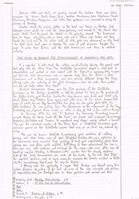
Paper - ''Commissioners'' by Gary Tremain Five pages handwritten paper; no date; title is written in with pencil at LH top of first page). References to earlier settlers - pioneers of Bendigo - Messrs Sherit, Heape, Grice, Lachlan MacKinnon, Colin MacKinnon, Donald MacKinnon, McCallum, Hodgkinson, Catto. Heading on first page - ''Five Years in Bendigo - The Establishment of Authority, 1851-1855. Reference to ; Goldfields Commission; Assistant Commissioner Horne; Captain Dana; George Gilbert; Cockburn; Chief Commissioner Wright; Captain Bull; ''digger hunting''; Joseph Panton; ''Red Ribbon Movement''; Chief Commissioner of Police, Mitchell; Lachlan McLachlan; Simon O'Neill; Sergeant Richards; Eureka; Commissioner Rede (in Ballarat).Gary Tremairbendigo, history, early bendigo, goldfields, red ribbon movement, mining of waste lands of the crown. -
 Ballarat Tramway Museum
Photograph - Colour Photograph/s - set of 2, Austin Brehaut, 18/11/2002 12:00:00 AM
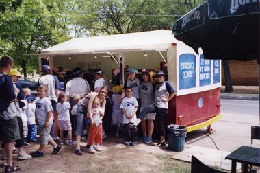
Set of two colour photographs of BTM hosting the "cops n' kids", charter on 18/11/2002, taken by Austin Brehaut on Kodak Royal Paper. Included with the worksheet file is an article prepared by Dave O'Neil and edited by Simon Green for Jan. 2003 issue of Fares Please! 2264.1 - Group at the ice-cream tram. 2264.2 - Crew with some of the charter participants. A third photograph - Dave O'Neil and participants standing by No. 40 - sent to Trolley Wire Editor 12/1/2003. Shown in image only. With worksheet is a Courier Cutting of 9/6/03 about Sgt John Moloney, organiser for the event and his receipt of the Australian Police Medal. - see related documents.2264.1 - " 'Cops n' Kids' trip 18.11.02 at the 'other' tram." / APB" in blue ink. 2264.2 - " 'Cops n' Kids' charter 18.11.02 with crew Austin Brehaut and Dave O'Neil" / "APB" in blue ink.charters, cops n' kids, tram 40 -
 Kew Historical Society Inc
Archive (Sub-series) - Subject File, Kew Court House - 2000-2005, 2000
Various partiesReference, Research, InformationSecondary Values (KHS Imposed Order)Subject file containing information about the heritage significance of the Kew Court House (and Police Station) in High Street, Kew. Most of the file contains correspondence between a number of interested parties including the Kew Historical Society which was leading the campaign to have the building/precinct preserved and used for community purposes. Letters and submissions include those from the Department of Treasury & Finance, Ray Tonkin (Heritage Victoria), Dr. Robert Dean MLA, Judith Voce, Hon David Davis MLC, John Lenders MP, Hon John Thwaites, Andrew McIntosh MLA and officers of the Kew Historical Society. The file also contains records of interview and memos and meeting minutes relating to the campaign.kew - history, kew court house, kew police station, heritage campaigns - kew (vic)kew - history, kew court house, kew police station, heritage campaigns - kew (vic) -
 The 5th/6th Battalion Royal Victoria Regiment Historical Collection
Plaque - Presentation Plaque, 32 x Plaques
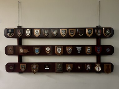
Collection of plaques presented to the unit over the years 1x Plaque made of 3 hoeizontal varnished timber beams with plaques affiixed and suspended from the wall via chains (Gordan Highlanders + Royal Fusiliers + 1 RRF + 2 Fusiliers + North Hampton Shire Regiment + The lake superior Scottish regiment + Royal Scots Dragon guards + Royal Warwickshire Fusiliers + King's Regiment + Light infantry + Royal Leicestershire regiment + RRF + 3 DIV + RAE + Villers Bretonneux + City of sunshine + City of Melbourne + Hauraki + 3 EME + Aitape Tread Warily + Victoria Police + AFP + KSEA FOR ASSN + 39 BN + 6 RMR + Swan Regiment + MPDRANR + 10 SQN + 36 SQN + MTU + London + [blank] 5/6 rvr, plaque -
 Melbourne Tram Museum
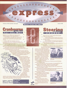
Newsletter, The Met, Public Transport Corporation, "Express - News from The Met - Autumn 1995", "Express - News from The Met - Summer `1995/96" and Autumn 1996", March 1995 to Autumn 1996
.1 - Newsletter, large format, special size titled "Express - News from The Met - Autumn 1995", four pages. Has stories about the Cranbourne electrification, female traffic staff on the buses and trams, refurbishment of W class trams, METROL, punctuality, history dates, railways, CSE's and a list of Melbourne events. .2 - as above - Express - News from The Met - Summer `1995/96" - rail timetable changes, night rider buses, police, fares and a list of Melbourne events. .3 - as above - Express - News from The Met - Autumn 1996"- Grand Prix, Franklin St terminus replaced by Melbourne University Superstops, railway power supply and a list of Melbourne events.trams, tramways, the met, women, cse, customer service employees, railways, w class, buses, fares, police, security, franklin st, victoria st, melbourne university, grand prix -
 Bendigo Military Museum
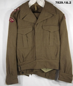
Uniform - BATTLE DRESS, ARMY, 1953 and 1960's
Names recorded on manufacturers label on jacket. "J.E. COOK", "W. RICHARDSON", "MENTONE GRAMMAR".1. Jacket - Khaki colour wool serge fabric. Battle Dress style, belted at waist with metal buckle. Brown plastic buttons. Collar, shoulder epaulettes with three red, cream and brown fabric rank insignia = Captain. Two front pockets with concealed button down flap. Shoulder sleeve insignia - red with cream colour embroidered lettering "ROYAL AUSTRALIAN ARMY/ MEDICAL CORPS". Sleeves with cuff and button. Light Khaki colour cotton fabric - pocket and waist lining. Manufacturers white cotton fabric label (two) on right pocket lining. 2. Trousers - khaki colour wool serge fabric Battle dress style. Two side pockets, two inset rear pockets with concealed button flaps and one patch pocket left thigh with concealed button flap. Five button fly. Waistband with button down belt keepers. Trouser cuffs have fabric tab with two buttons. khaki colour cotton fabric lining to waistband and pockets. Manufacturers white cotton label on waistband. 3. Braces - set of cotton elastic braces with brown leather button attachments for trousers. Stripes on elastic are beige, black, blue, cream and green in colour. Metal slides for adjustment to wearers size, with stamped lettering. brown leather strap joiner.Manufacturers information on labels. 1. Black ink print "REGIMENTAL NO./ NAME". Handwritten blue ink pen "JE COOK/ MENTONE/ W. RICHARDSON/ GRAMMAR". Red ink print label "M.TX/ SIZE 8" , Purple ink stamp on fabric lining "D^D/ MADE IN AUSTRALIA/ 1953". 2. Black ink print "REGIMENTAL NO./ NAME". Red ink print "M.TX/ SIZE 5". 3. Lettering on metal slides "POLICE/ AND/ FIREMEN". Black ink stamp - back leather strap joiner "???/ ^/ 196?/ 38".uniform, army, battle dress -
 Kew Historical Society Inc
Plan, Melbourne & Metropolitan Board of Works : Borough of Kew : Detail Plan No.1588, 1904
The Melbourne and Metropolitan Board of Works (MMBW) plans were produced from the 1890s to the 1950s. They were crucial to the design and development of Melbourne's sewerage and drainage system. The plans, at a scale of 40 feet to 1 inch (1:480), provide a detailed historical record of Melbourne streetscapes and environmental features. Each plan covers one or two street blocks (roughly six streets), showing details of buildings, including garden layouts and ownership boundaries, and features such as laneways, drains, bridges, parks, municipal boundaries and other prominent landmarks as they existed at the time each plan was produced. (Source: State Library of Victoria)This plan forms part of a large group of MMBW plans and maps that was donated to the Society by the Mr Poulter, City Engineer of the City of Kew in 1989. Within this collection, thirty-five hand-coloured plans, backed with linen, are of statewide significance as they include annotations that provide details of construction materials used in buildings in the first decade of the 20th century as well as additional information about land ownership and usage. The copies in the Public Record Office Victoria and the State Library of Victoria are monochrome versions which do not denote building materials so that the maps in this collection are invaluable and unique tools for researchers and heritage consultants. A number of the plans are not held in the collection of the State Library of Victoria so they have the additional attribute of rarity.Original survey plan, issued by the MMBW to a contractor with responsibility for constructing sewers in the area identified on the plan within the Borough of Kew. The plan was at some stage hand-coloured, possibly by the contractor, but more likely by officers working in the Engineering Department of the Borough and later Town, then City of Kew. The hand-coloured sections of buildings on the plan were used to denote masonry or brick constructions (pink), weatherboard constructions (yellow), and public buildings (grey). This plan shows the original configuration of the Kew Post Office, Court House and Police Station, which had opened in 1888. This configuration was to essentially remain until the purchase of the Court House and Police Station by the City of Boroondara in 2007 and its subsequent renovation. Interestingly, the MMBW surveyors incorrectly labelled parts of the complex. In the triangle in front of the Post Office, before the erection of the Kew Cenotaph in 1925, was located a lawn and the Queen Victoria Jubilee Fountain. While many of the shops on the south side of High street had been constructed by 1903 a number of sites were still used as vegetable gardens. Further along High Street, on the corner of Charles Street, the Salvation Army Barracks can be seen on the plan. These Barracks predate the later Citadel and ‘Young People’s Hall’ that were opened in 1919. At 22 Charles Street can be seen the house of James Venn Morgan. Hailed as the ‘father of Kew’, Morgan arrived in Melbourne in 1840. He was first engaged as a bookmaker, but a fortunate venture on the goldfields enabled him to purchase land in Kew. He conducted a market garden and dairy in Kew for many years.melbourne and metropolitan board of works, detail plans, maps - borough of kew, mmbw 1588, cartography -
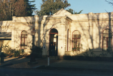
 Eltham District Historical Society Inc
Photograph - Digital Photograph, Alan King, Eltham Court House, 730 Main Road, Eltham, 28 December 2007
The Eltham Court House is Eltham's oldest public building. It was classified by the National Trust in 1977. In 1857 five Eltham residents petitioned the licensing magistrates of the Heidelberg district asking for better police protection, including from itinerant gold prospectors who turned to crime when their quest was unsuccessful. In response the Eltham Courthouse was constructed in 1860. Over the years it has also been used for other activities, including for electoral polling purposes, inquests, early meetings of the Eltham Roads Board and even as an overflow classroom. This type of localised solution is characteristic of the self-reliance preserved in Eltham today. The court house is an important symbol of the spirit which makes Eltham distinctive as a community. The Eltham Courthouse is historically significant because its construction was intended to emphasise the centralised control over law and order in the Colony of Victoria in the wake of the 1852 Snodgrass committee report on the Victorian police force and the resulting Police Regulation Act (1853). The nature of the Court House planning and use of architectural devices make the building's function easily interpreted. The arrangement of rooms, with public entry and clerical rooms to the rear, and the use of raised floor levels throughout these spaces to signify relative rank is easily perceived. The distinction in entries, public, magistrate and person-in-custody, and the existing court furniture enhances appreciation of this building. The Eltham Court House is one of only two intact examples in the state of this simple design with projecting entry. The building is of architectural significance because it retains intact early features. These include use of handmade bricks, simple decoration, roof trusses, timber ceiling boards, original windows, doors and associated hardware and a collection of court furniture. Additions to the court house have been done in a manner which did not interfere with the fabric of the original building. Typical cases heard before the Court of Petty Sessions included financial debt, straying livestock, theft, assault, drunkenness, public disorder, truancy, motor vehicle offences, unregistered animals and failing to have children attend school, or be vaccinated. The courthouse operated for over 120 years before it closed in 1985. In April 2021, Nillumbik Shire Council authorised restoration of the building and furnishings. The extensive works required for the total restoration of this highly valued heritage building was undertaken by Ducon Building Solutions and other specialist contractors. Covered under Heritage Overlay, Nillumbik Planning Scheme. Victorian Heritage National Trust of Australia (Victoria) State significance Published: Nillumbik Now and Then / Marguerite Marshall 2008; photographs Alan King with Marguerite Marshall.; p65This collection of almost 130 photos about places and people within the Shire of Nillumbik, an urban and rural municipality in Melbourne's north, contributes to an understanding of the history of the Shire. Published in 2008 immediately prior to the Black Saturday bushfires of February 7, 2009, it documents sites that were impacted, and in some cases destroyed by the fires. It includes photographs taken especially for the publication, creating a unique time capsule representing the Shire in the early 21st century. It remains the most recent comprehenesive publication devoted to the Shire's history connecting local residents to the past. nillumbik now and then (marshall-king) collection, eltham, eltham court house, main road -
 Melton City Libraries
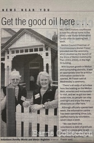
Newspaper, Get the good oil here…, 2001
"A court was established in Melton by 1864, when the first recorded case was heard before Mr BA Porter JP, with Mr A Carroll as the Clerk of Courts. John James was convicted of being drunk, for which he was fined five shillings or 24 hours imprisonment. The court was held in the ‘long room’ of the old Melton Hotel, before moving to rented accommodation at the Raglan Hotel, and finally to the Roads Board office. Tenders for construction of the present building were called for by the Public Works Department on 13th February 1892. The architect Samuel Edward Brindley was born in Birmingham, England, in 1842. He was articled to the local architect, J.R. Botham, FRIBA, before emigrating to Victoria where he was employed as an architect in the Education Department from 18 August 1873. With the amalgamation of the architectural branch of the Education Department with the Public Works Department in 1884, Bindley was placed in charge of Victorian government building design for the North-Western District. In 1975, the Melton and District Historical Society became concerned at hearsay that the court house was to be demolished to make way for carparking space. Melton had been declared a ‘satellite city’ and was developing rapidly. A new shopping centre had recently been built at a setback of 60 feet (c.18 metre) from 323-329 High Street, and the court house, together with the adjacent weatherboard police station, had been left standing alone. A new police station was planned, and the weatherboard police station was subsequently demolished. In its nomination of the building for National Trust classification the Society argued that the Court House was ‘the best of two early buildings left in the main street’ (the other being a bluestone hotel) and that its loss would be ‘tragic’. However the nomination was unsuccessful, the National Trust at the time judging that it was of no particular ‘distinction’ or ‘antiquity’. The building continued to be used as a court house at least until 1991 when the Department of Housing and Construction (formerly the PWD) conducted a heritage study of court houses. By this time Federation-era architecture had achieved acceptance within the heritage movement. The building was recognised as being ‘the only surviving example in brick of the Federation Queen Anne style which was used for court houses only twice.’ Twenty years later when it was proposed to modify the eastern façade of the building to accommodate a café, the M&DHS was again concerned. This time the National Trust objected that the proposed extension would be an over-development of the site, and questioned the changes to the interior court room furnishings and fittings. The site never appears to have been nominated to the Victorian Heritage Register. It has since been converted into the Shire of Melton Tourist Information Centre". Opening of the Visitor Centre in Meltoncouncil, local architecture -
 Eltham District Historical Society Inc
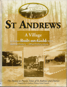
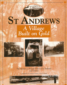
Book, St Andrews Primary School Council, St Andrews: A Village Built on Gold : the history to present day of St Andrews and District compiled by St Andrews Primary School Council, 2008
This history of the Victorian town of St. Andrews (formerly Queenstown) and its surroundings was written to celebrate the 140th anniversary of St Andrews Primary School. Describes the displacement of the Aboriginal inhabitants of the area, European settlement and the Gold Rushes and the Caledonia diggings. Discusses establishment of the school, church and cemetery and various other notable events. The school in 1998 and speculations on the future by primary school pupils. Contents: Introduction The First People Mining- What a rush! The School The Church Queenstown Cemetery The Hotels The Police Paddocks The Families Queenstown in the early twentieth century The Queenstown Bush Fire Brigade The 1st Queenstown Scout troop Queenstown, the 1940s and 1950s The Characters Odds and Sods St Andrews - The Present Times The Future St Andres Primary School in 1998This book is significant in that it documents the history of the St Andrews community from the indigenous presence through its foundation during the Victorian Gold Rush through to local bushfires and predictions of the future by local primary schools students in 1998. It remains the only significant secondary source publication written specifically on this rural community.Reprint edition with index 158 p. : ill., ports ; indexEx Eltham College copy Bendigo bank donation label inside cover Title page with stampings for D.D. Davey Senior Library Rear page date due slip st andrews, queenstown -
 Eltham District Historical Society Inc
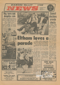
Newspaper clipping, Eltham loves a parade, Diamond Valley News (Eltham), Vol. 33, No. 32, 14 August 1979, p1, 1979
Feature news story about 1979 Eltham Parade with photo of Society members Joh Ebeli and Russell Yeoman pushing Peter Bassett-Smith along in a wheelbarrow. Others featured were Eltham Rugby club float and Anne Mandel of the Slovenian Association of Melbourne. Other story on "Council elections provide shocks" featured the defeat of Eltham sitting councillors, Ken Hines and Helen Wells with Shire president Cr, Robert Marshall returned with a commanding majority. Reverse side (p2) story "Laughing cop no softy" is a feature article on Tony Zalewski of Greensborough CIB who was the key policeman involved in a hour-long siege in Norfolk Crescent, Bundoora in 1978 and for which he received the Victoria Police Valour AwardNewsprint page1979, anne mandel, ansell and muir, bundoora, elections, eltham festival, eltham rugby football club, greensborough cib, helen wells, joh ebeli, ken hines, lyon bros ford, norfolk crescent, parade floats, peter bassett-smith, robert marshall, russell yeoman, shire of diamond valley, shire of eltham, shire of eltham historical society, siege, slovenian association of melbourne, tony zalewski, victoria police valour award -
 Eltham District Historical Society Inc
Book, St Andrews Primary School Council, St Andrews: A Village Built on Gold : the history to present day of St Andrews and District compiled by St Andrews Primary School Council, 1998
This history of the Victorian town of St. Andrews (formerly Queenstown) and its surroundings was written to celebrate the 140th anniversary of St Andrews Primary School. Describes the displacement of the Aboriginal inhabitants of the area, European settlement and the Gold Rushes and the Caledonia diggings. Discusses establishment of the school, church and cemetery and various other notable events. The school in 1998 and speculations on the future by primary school pupils. Contents: Introduction The First People Mining- What a rush! The School The Church Queenstown Cemetery The Hotels The Police Paddocks The Families Queenstown in the early twentieth century The Queenstown Bush Fire Brigade The 1st Queenstown Scout troop Queenstown, the 1940s and 1950s The Characters Odds and Sods St Andrews - The Present Times The Future St Andres Primary School in 1998This book is significant in that it documents the history of the St Andrews community from the indigenous presence through its foundation during the Victorian Gold Rush through to local bushfires and predictions of the future by local primary schools students in 1998. It remains the only significant secondary source publication written specifically on this rural community.158 p. : ill., ports ISBN 0646353756st andrews, queenstown -
 Victoria Police Museum
Police Stations (Amherst)
Amherst, a former gold rush town, is located 13 kilometres south-west of Avoca on the Pyrenees Highway in the Pyrenees Shire in Victoria, Australia. It is 183 kilometres north west of Melbourne. The police station, in Camp Street, opened in 1853 and was originally in the District of Castlemaine. In 1857 it came under the District of Avoca, in 1858 the District of Carisbrook, in 1859 the District of Avoca, in 1866 the District of Maryborough, in 1879 the South Western District, and Central District in 1883. The station closed on 8 August 1892. In 1861 the station was staffed by 1 Mounted Constable, 1 Foot Senior Constable and 2 Foot Constables. Amherst "Outstation" opened in 1854 and was part of the Avoca District until it closed in 1856 An outstation was opened in 1854 and closed in 18561 photopolice stations; amherst police station -
 Eltham District Historical Society Inc
Photograph, Fred Mitchell, Jarrold Cottage, 5 September 2007
Three historically significant buildings are here at 701 Main Road, opposite Dalton Street, Eltham. Jarrold Cottage or White Cloud was built about 1863 and remains one of the oldest buildings in Eltham. It was once used temporarily as Eltham’s first police station. The Jarrolds were a pioneer family of market gardeners and building tradesmen over six decades and from the early 1940s, with the Skippers and other prominent local figures involved in the construction and development of the Montsalvat Artists' Colony. Len Jarrold, a carpenter, worked at Montsalvat from the beginning and became foreman of works for the splendid 1938 Great Hall. The Skipper family, also involved with Montsalvat, were associated with Jarrold Cottage from 1944 when it was purchased by Lena Skipper. Digital copy of colour photographfred mitchell collection, 2007, eltham, jarrold cottage, main road -
 Federation University Art Collection
Painting, Diana Nikkelson, 'My Family, My Life Goes On' by Diana Nikkelson
Diana NIKKELSON (c1943-30 December 2022) Diana Nikkelson is a Ballarat-based Gunditjmara elder. Her grandfather was Watchobaluk. A part of the stolen generation, Diana Nikkelson was one of 10 children, and she had nine children of her own. A founding member of the Ballarat and District Aboriginal Co-operative in the late-70s, Diana Nikkelson was a board director for 16 years and chair for six years. She worked on the Bunjil the Eagle installation at the Koorie Playground at Lake Wendouree, and designed the goanna which was etched into the paving along Police Lane in 2006, and has painted murals across Ballarat. This item is part of the Federation University Art Collection. The Art Collection features over 000 works and was listed as a 'Ballarat Treasure' in 2007.AboriginalThis work by Ballarat-based Gunditjmara elder Diana Nikkelson was commissioned by the University of Ballarat (later Federation University) for use on the Aboriginal Employment Strategy brochure. The central figures in this painting represent the artist and the fathers of her children. The outer groups are Diana Nikkelson’s children and their families. art, artwork, diana nikkelson, aboriginal, dreaming, nikkelson, gunditjmara, aboriginal employment strategy -
Clunes Museum
Painting - PAINTINGS, David Williams
Images of; Horse Trough & Wagon Residence 94 Bailey Street Former Presbytery St. Thomas Aquinas Former Clunes Free Library Residence 25 Camp Street Monument 100 years of gold Clunes in Melb Monument Former butcher's shop Fraser Street Residence & shops 41-43 Fraser Street Clunes School of Mines Clunes War Memorial Residence 32 Leslie St Clunes Former suspension bridge Former St Paul's Vicarage 42 Service Street Former Police Office Former Police residence Portable Lock Up Former Dow Residence 9 Hill St Former Hall & Fire Station 2 Hill St St Paul's timber Church hall St Paul's Church Masonic Lodge 23 Service St St Paul's Pulpit Masonic Lodge interior Everhard cordial bottles Scythes in Clunes Museum Ascot Blacksmith shop Former Ascot hotel MIA Hall Ascot The Coghill Monument Former Methodist Church Coghills Creek Clunes Cemetery Chapel Maiden Hill Homestead shearing shed Beckworth Court stables Beckworth Cour shearer's quarters Former School Evansford Glengower Outbuilding Amerst Former Mortuary 46-50 Fraser Street Wood fired heater Beckworth court farm shed Gold mine trolley Servant's bells Maiden Hill cow bail Former South Clunes school 29 George Street 70 Fraser Street Former Post Office "Allowah" Clunes Street Ascot "Homestead" Beackwith Court "The Meat House" Beckwith Court "Shearing Sheds" Beckwith Court Evansford Community Hall 54 watercolours remaining from the 2003 exhibition held at Clunes, all unframed, depicting Clunes and surrounds architecture and streetscapes.watercolour, 2003 exhibition -
 Ballarat Tramway Museum
Document - Report, COTMA, "Report of Sub-Committee on Fares and Sections appointed at Australasian Tramways Conference 1929", 1929
Demonstrates a report into tram fares and tickets around Australasia.Report - 13 foolscap duplicated pages, stapled along the left hand edge, titled "Report of Sub-Committee on Fares and Sections appointed at Australasian Tramways Conference 1929" Reports on a questionnaire to 14 different systems - Bendigo considered the same as Ballarat for the purposes of the report. Looks at the Section and their average length, Overlapping sections, fares, children fares, Sunday and holiday rates, workmen's concession tickets, scholars', swimming tickets, blind passes, police officers, civil servants, municipal bodies, concessions to charitable institutions, defence force, boy scouts, state members and officials, employee's passes, periodical or prepaid tickets, specials charges, passenger luggage. Compares to the USA, flat fares, one man trams.Has "Mr Mawby" in ink on front cover and "Copy sent to Mr Old 22.7.30"trams, tramways, tickets, fares, sections, australasian tramway conference, ballarat -
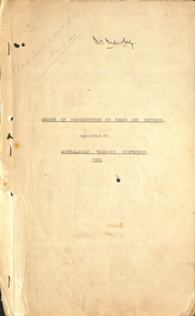
 Ballarat Tramway Museum
Pamphlet, Warren Doubleday, "Law and Order on the Trams", Oct. 1997
713.1 & 71.32 - A4 sized originals (ex Laser Printer) of BTM Exhibition brochure titled "Law and Order on the Trams". Prepared for the 1997 CHHA Exhibition, 11&12 October 1997, then at the depot. Features three photographs - opening of Lydiard St. North, ESCo No. 2 and power station and group of ESCo employees in front of the Grenville St. shelter. Has notes on horse trams, trams and MP's during World War II, the last tram of the day and policing employees. Printed onto "Premium coated ink Jet" paper, 25% cotton. Printed by a HP6P printer. 713.3 - photocopy of 713.1 and .2 as handed out, printed onto white "Reflex" paper. Image added 20-12-2016trams, tramways, law and order, employees, police, esco -
Bendigo Historical Society Inc.
Document - HARRY BIGGS COLLECTION: EAGLEHAWK LOGS APPEAL
Documents. Harry Biggs Collection. Item 1 - Three letter pro-formas with the letter head 'Eaglehawk Logs Appeal' Town Hall, Eaglehawk, Ph. 8122. R. Manning. Chairman. Dear Sir. . . Includes photo of log cabin in left hand corner. Item 2 - Three banners - Support Eaglehawk Lock-up Appeal. Item 3 - Black & white photo of the log lock-up in Eaglehawk. Item 4 - Newspaper photo of the log lock-up in Eaglehawk with some information about it. Paper & date unknown. Item 5 - An orange card a photo of the Logs at rear of police station Eaglehawk. A written account of the Logs history & construction description. Item 6 - Jotting regarding Eaglehawk lock-up.place, building, site, harry biggs collection, log lock-up, eaglehawk -
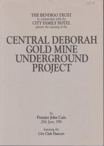 Bendigo Historical Society Inc.
Booklet - Central Deborah Gold Mine Underground Project, 20th June, 1986
Two page booklet. On front cover: The Bendigo Trust in conjunction with the City Family Hotel. present the opening of the Central Deborah Gold Mine Underground Project by Premier John Cain 20th June, 1986, featuring City Club Dancers. Contents include: 'The Legend of Golden Lady Deborah'; the 'Awakening of Deborah' and a description of the Central Deborah Goldmine. Listed are acknowledgements of assistance given by the City Family and City Club; Gillies; Sandhurst Dairies; McDonalds; Swan Breweries; 3BO;, Domenic House of Hair and Beauty; ESG Studios, Selex-Decal; Victoria Police Band; V-Line; Bendigo Timber; Stonemans; Alan Williams Sound; Radio Rentals; Waterfall Quarries; Arthur Holt; Bart N Print and Sandhurst Town. central deborah gold mine, gold, opening of mine, john cain -
 The Beechworth Burke Museum
Photograph
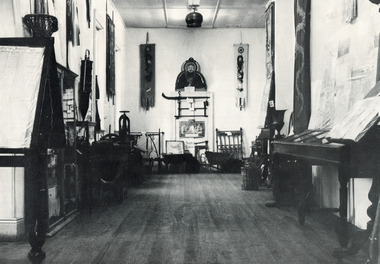
This black and white photograph is estimated to have been taken c1900 inside the Burke Museum. Several objects part of the museum collection at the time can be seen, with a high number of Asian influence objects visible; potentially Chinese in origin, as several Chinese villages were located around Beechworth and across Spring Creek, from the mid 1800s. The Burke Museum is part of the Precinct of Beechworth, which was established upon the discovery of gold in 1852. Originally built as the Beechworth Athenaeum in 1857, the museum was later renamed to the Robert O'Hara Burke Memorial Museum, more commonly known as the Burke Museum, in honour of the famous explorer and former Beechworth Superintendent of Police, Robert O'Hara Burke, after his death in 1861 at Coopers Creek during the famed ill-fated Burke and Wills expedition.This photograph is contextually, historically and socially significant due to its connection to both the Burke Museum and Chinese culture in and around Beechworth during the mid-1800s through to 1900s. Around 4700 people of Chinese heritage lived at the Ovens goldfield by April of 1857, representing one-quarter of the entire population at the time. The object holds strong representativeness to the history of the Burke Museum and to the objects in its collection. Its interpretive capacity could be supported and enhanced with other photographs and objects in the collection. Collectively, these records and objects could provide an insight into the museum's collection and its relationship with the origins of the objects.Black and white rectangular photograph printed on paper. Unmounted; taped to paper. beechworth, spring creek, chinese, burke museum, immigration, chinese immigration, ovens goldfield, china, museum, robert o'hara burke, burke and wills expedition, burke and wills, goldfields -
 The Beechworth Burke Museum
Photograph, Unknown
This undated photograph depicts two people standing in the vestibule entrance at the Burke Museum, Beechworth. The museum site dates to the 1857 founding of the Beechworth Public Library and Athenaeum by a newly formed Young Men's Association (YMA). In 1863 the museum was dedicated as a memorial to former Beechworth police superintendent (1854-1858) and explorer Robert O’Hara Burke, following Burke’s death from malnutrition on the Burke and Wills expedition in 1861. Funded by the Victorian Government and the Royal Society of Victoria, the officially titled 'Victorian Exploring Expedition' was tasked with being the first European party to traverse Australia from south to north. The Burke Museum holds objects from the famous expedition and explores the multi-layered history of Beechworth and surrounds from the gold rush era to the present.This photograph is historically significant for its depiction of the Burke Museum and Loch Street streetscape. The Burke Museum is Australia’s oldest regional museum and part of Beechworth's Historic and Cultural Precinct, one of Australia’s best preserved historic-town sites and a popular tourist destination. Once the government centre for a vast gold fields region, this collection of nationally significant buildings tells the story of how Australia grew and prospered. The frequent use of honey-coloured local granite as a building material, which can be seen in the museum's fabric, gives Beechworth’s historic buildings a distinct and cohesive local character. This photograph may be compared and studied alongside other images of historic buildings in the Burke Museum Photographic Collection.Rectangular colour photograph printed on photographic paper.Reverse: 3440burke museum, beechworth athenaeum, beechworth library, beechworth historic precinct, robert o'hara burke, australia's oldest regional museum, indigo shire, beechworth athanaeum, beechworth historic building, historic precinct, honey-coloured local granite, victorian gold fields, historic towns in victoria, victoria's high country, colonial australia, beechworth tourism, things to see in beechworth, beechworth historic trail, historic victorian architecture, burke and wills expedition, first europeans to cross australia, young men's associations -
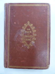 Warrnambool and District Historical Society Inc.
Book, The book of sacred song, 1864
This book has been given to John Ardlie by Lewis Gilles in 1866. John Martin Ardlie came to Warrnambool in 1852 as the Clerk of Courts and remained in this position until 1868. He died in 1872. He was a leading figure in community affairs for twenty years and Ardlie Street in Warrnambool is named after him. His family home was Wyton, site of the old convent at Emmanuel College today. Lewis Gilles, important in the early history of Tasmania as a bank owner and breeder of cattle, came to Warrnambool in 1854 as the first resident Police Magistrate. He remained until 1866 when he went to England (the occasion of his presentation of this book to John Ardlie). He died in 1884 in South Australia. Gilles Street in Warrnambool is named after him.This book is of high significance because of its connection to two very important early residents of Warrnambool – John Ardlie and Lewis Gilles. This is a hard cover book of 336 pages. The cover is brown with gold ornamentation and lettering on the front cover and spine. The pages are gilt-edged. The first letter of each hymn is ornamented and there is an illustration covered with tissue paper on the first page. One page shows silverfish damage and the cover is partly detached from the binding. The cover is frayed in places and a little stained. The inscription is handwritten in black ink. ‘Presented to J. M. Ardlie by his friend and comrade L.W. Gilles 1864 Worthing Sussex on departing from Warrnambool 4 May 1866’. john ardlie, lewis gilles, history of warrambool -
 Kiewa Valley Historical Society
Photo - Bogong Township, March 1944
In 1940 Field Headquarters for the Kiewa Scheme were established at Bogong with office, workshop facilities and accommodation for workmen, staff and some families constructed. (There had been a 'tent camp' on this site in 1939 but was destroyed by bushfires) Construction of accommodation continued until 1947. A total of 40 houses plus a hostel for single staff, post office, police station, medical centre and primary school all with water and sewerage and electricity supply. The staff hostel was known as Kiewa House and is now occupied by the Education Department. Lake Guy was named after Mr. L.T. Guy who was the Resident Engineer in charge of construction work and associated activities on the Kiewa area. He held this position from 1939 to November 1946 when he was transferred to Head Office. The Bogong Township was developed firstly as an accommodation centre (base camp) for construction workers employed under the Kiewa Hydroelectric Scheme. Due to the influx of European workers into the Township the beautification of the immediate surrounds (gardens etc.) had a distinct European flavour. This environment has been very beneficial for tourism in later years. At the completion of the scheme, in the 1960's, the village was opened to public/tourism use. Strict environmental control has not allowed for any extensive redevelopment in tourist accommodation and basically restricted it to the accommodation initially built for the construction workers. Activities such a bike riding, snow skiing, restricted horse riding and bush walking on the Alpine plains and mountains are now a viable part of the Kiewa Valley Tourist Industry. The lake is one of the many water storage reservoirs used to supply the power stations their main power to run the huge turbines generating the final product, electricityBlack and white photograph of Bogong Township taken March 1944Handwritten on the back of photo - Township March '44bogong village, secv -
 Kiewa Valley Historical Society
Photograph - Bogong Village (7 copies), Approx 1940
In 1940 Field Headquarters for the Kiewa Scheme were established at Bogong with office, workshop facilities and accommodation for workmen, staff and some families constructed. (There had been a 'tent camp' on this site in 1939 but was destroyed by bushfires) Construction of accommodation continued until 1947. A total of 40 houses plus a hostel for single staff, post office, police station, medical centre and primary school all with water and sewerage and electricity supply. The staff hostel was known as Kiewa House and is now occupied by the Education Department. Lake Guy was named after Mr. L.T. Guy who was the Resident Engineer in charge of construction work and associated activities on the Kiewa area. He held this position from 1939 to November 1946 when he was transferred to Head Office. The Bogong Township was developed firstly as an accommodation centre (base camp) for construction workers employed under the Kiewa Hydroelectric Scheme. Due to the influx of European workers into the Township the beautification of the immediate surrounds (gardens etc.) had a distinct European flavour. This environment has been very beneficial for tourism in later years. At the completion of the scheme, in the 1960's, the village was opened to public/tourism use. Strict environmental control has not allowed for any extensive redevelopment in tourist accommodation and basically restricted it to the accommodation initially built for the construction workers. Activities such a bike riding, snow skiing, restricted horse riding and bush walking on the Alpine plains and mountains are now a viable part of the Kiewa Valley Tourist Industry. The lake is one of the many water storage reservoirs used to supply the power stations their main power to run the huge turbines generating the final product, electricity. Evidence can be seen of the 1939 bushfires.Set of 7 identical black and white photographs of Bogong Village after 1939 bush firesHandwritten on the back of one photo - Bogong Village approx. 1940, after 1939 bush fires. Staff residences to left. Kiewa House, General offices and test lab to the right. Hand drawn map on the back of one photo.bogong village, secv -
 Kiewa Valley Historical Society
Photo - Bogong Village Township, October 8, 1946
In 1940 Field Headquarters for the Kiewa Scheme were established at Bogong with office, workshop facilities and accommodation for workmen, staff and some families constructed. (There had been a 'tent camp' on this site in 1939 but was destroyed by bushfires) Construction of accommodation continued until 1947. A total of 40 houses plus a hostel for single staff, post office, police station, medical centre and primary school all with water and sewerage and electricity supply. The staff hostel was known as Kiewa House and is now occupied by the Education Department. Lake Guy was named after Mr. L.T. Guy who was the Resident Engineer in charge of construction work and associated activities on the Kiewa area. He held this position from 1939 to November 1946 when he was transferred to Head Office. The Bogong Township was developed firstly as an accommodation centre (base camp) for construction workers employed under the Kiewa Hydroelectric Scheme. Due to the influx of European workers into the Township the beautification of the immediate surrounds (gardens etc.) had a distinct European flavour. This environment has been very beneficial for tourism in later years. At the completion of the scheme, in the 1960's, the village was opened to public/tourism use. Strict environmental control has not allowed for any extensive redevelopment in tourist accommodation and basically restricted it to the accommodation initially built for the construction workers. Activities such a bike riding, snow skiing, restricted horse riding and bush walking on the Alpine plains and mountains are now a viable part of the Kiewa Valley Tourist Industry. The lake is one of the many water storage reservoirs used to supply the power stations their main power to run the huge turbines generating the final product, electricityBlack and white photograph of Bogong Village which appeared in the Herald Sun newspaper on October 8, 1946. Page 13Handwritten on the back - Town of Bogong on a rugged mountain slope above Lake Guy. State Electricity Committee workers on the Kiewa Hydro Electric scheme live here in all electric homes. Stamped on the back - Copyright Not for reproduction Herald Sun Feature Service Melbourne Australiabogong village; lake guy; kiewa hydro electric scheme -
 Kiewa Valley Historical Society
Postcard - Lake Guy and Bogong Village
In 1940 Field Headquarters for the Kiewa Scheme were established at Bogong with office, workshop facilities and accommodation for workmen, staff and some families constructed. (There had been a 'tent camp' on this site in 1939 but was destroyed by bushfires) Construction of accommodation continued until 1947. A total of 40 houses plus a hostel for single staff, post office, police station, medical centre and primary school all with water and sewerage and electricity supply. The staff hostel was known as Kiewa House and is now occupied by the Education Department. Lake Guy was named after Mr. L.T. Guy who was the Resident Engineer in charge of construction work and associated activities on the Kiewa area. He held this position from 1939 to November 1946 when he was transferred to Head Office. The Bogong Township was developed firstly as an accommodation centre (base camp) for construction workers employed under the Kiewa Hydroelectric Scheme. Due to the influx of European workers into the Township the beautification of the immediate surrounds (gardens etc.) had a distinct European flavour. This environment has been very beneficial for tourism in later years. At the completion of the scheme, in the 1960's, the village was opened to public/tourism use. Strict environmental control has not allowed for any extensive redevelopment in tourist accommodation and basically restricted it to the accommodation initially built for the construction workers. Activities such a bike riding, snow skiing, restricted horse riding and bush walking on the Alpine plains and mountains are now a viable part of the Kiewa Valley Tourist Industry. The lake is one of the many water storage reservoirs used to supply the power stations their main power to run the huge turbines generating the final product, electricityBlack and white photographic postcard of Lake Guy and Bogong Village. Kiewa Hydro electric Project (showing Junction Dam in front)Handwritten on the back of postcard ' Like most of our camps, this looks like something from the Canadian Rockies' Stamped on the back - Valentine's Post Card A genuine photographlake guy, bogong village, secv -
 Kiewa Valley Historical Society
Photo - Bogong Township, September 1953
In 1940 Field Headquarters for the Kiewa Scheme were established at Bogong with office, workshop facilities and accommodation for workmen, staff and some families constructed. (There had been a 'tent camp' on this site in 1939 but was destroyed by bushfires) Construction of accommodation continued until 1947. A total of 40 houses plus a hostel for single staff, post office, police station, medical centre and primary school all with water and sewerage and electricity supply. The staff hostel was known as Kiewa House and is now occupied by the Education Department. Lake Guy was named after Mr. L.T. Guy who was the Resident Engineer in charge of construction work and associated activities on the Kiewa area. He held this position from 1939 to November 1946 when he was transferred to Head Office. The Bogong Township was developed firstly as an accommodation centre (base camp) for construction workers employed under the Kiewa Hydroelectric Scheme. Due to the influx of European workers into the Township the beautification of the immediate surrounds (gardens etc.) had a distinct European flavour. This environment has been very beneficial for tourism in later years. At the completion of the scheme, in the 1960's, the village was opened to public/tourism use. Strict environmental control has not allowed for any extensive redevelopment in tourist accommodation and basically restricted it to the accommodation initially built for the construction workers. Activities such a bike riding, snow skiing, restricted horse riding and bush walking on the Alpine plains and mountains are now a viable part of the Kiewa Valley Tourist Industry. The lake is one of the many water storage reservoirs used to supply the power stations their main power to run the huge turbines generating the final product, electricityBlack and white photograph of Bogong Township taken from Little Arthur fire track. September 1953Faded handwritten inscription on back - Bogong Township taken from Little Arthur fire track. Sept 1953bogong village, secv -
 Kiewa Valley Historical Society
Photo - First Bogong Camp, September 1950
In 1940 Field Headquarters for the Kiewa Scheme were established at Bogong with office, workshop facilities and accommodation for workmen, staff and some families constructed. (There had been a 'tent camp' on this site in 1939 but was destroyed by bushfires) Construction of accommodation continued until 1947. A total of 40 houses plus a hostel for single staff, post office, police station, medical centre and primary school all with water and sewerage and electricity supply. The staff hostel was known as Kiewa House and is now occupied by the Education Department. Lake Guy was named after Mr. L.T. Guy who was the Resident Engineer in charge of construction work and associated activities on the Kiewa area. He held this position from 1939 to November 1946 when he was transferred to Head Office. The Bogong Township was developed firstly as an accommodation centre (base camp) for construction workers employed under the Kiewa Hydroelectric Scheme. Due to the influx of European workers into the Township the beautification of the immediate surrounds (gardens etc.) had a distinct European flavour. This environment has been very beneficial for tourism in later years. At the completion of the scheme, in the 1960's, the village was opened to public/tourism use. Strict environmental control has not allowed for any extensive redevelopment in tourist accommodation and basically restricted it to the accommodation initially built for the construction workers. Activities such a bike riding, snow skiing, restricted horse riding and bush walking on the Alpine plains and mountains are now a viable part of the Kiewa Valley Tourist Industry. The lake is one of the many water storage reservoirs used to supply the power stations their main power to run the huge turbines generating the final product, electricityBlack and white photo of Bogong Village. September 1950Handwritten on the back - 1st Bogong Camp. SEC Kiewa Scheme Sept 1950bogong camp, bogong village, secv -
 Kiewa Valley Historical Society
Photo - Bogong Village Township
In 1940 Field Headquarters for the Kiewa Scheme were established at Bogong with office, workshop facilities and accommodation for workmen, staff and some families constructed. (There had been a 'tent camp' on this site in 1939 but was destroyed by bushfires) Construction of accommodation continued until 1947. A total of 40 houses plus a hostel for single staff, post office, police station, medical centre and primary school all with water and sewerage and electricity supply. The staff hostel was known as Kiewa House and is now occupied by the Education Department. Lake Guy was named after Mr. L.T. Guy who was the Resident Engineer in charge of construction work and associated activities on the Kiewa area. He held this position from 1939 to November 1946 when he was transferred to Head Office. The Bogong Township was developed firstly as an accommodation centre (base camp) for construction workers employed under the Kiewa Hydroelectric Scheme. Due to the influx of European workers into the Township the beautification of the immediate surrounds (gardens etc.) had a distinct European flavour. This environment has been very beneficial for tourism in later years. At the completion of the scheme, in the 1960's, the village was opened to public/tourism use. Strict environmental control has not allowed for any extensive redevelopment in tourist accommodation and basically restricted it to the accommodation initially built for the construction workers. Activities such a bike riding, snow skiing, restricted horse riding and bush walking on the Alpine plains and mountains are now a viable part of the Kiewa Valley Tourist Industry. The lake is one of the many water storage reservoirs used to supply the power stations their main power to run the huge turbines generating the final product, electricityBlack and white photograph of Bogong Village from across Lake Guy. Photo mounted on buff cardbogong village, secv