Showing 2027 items matching "station building"
-
 Kew Historical Society Inc
Slide - Kew Post Office, 1980
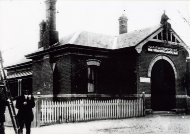
A civic campaign for new public offices developed in Kew in the 1880s. After much deliberation, the location chosen was the junction of Bulleen and Cotham Roads. The buildings were designed by George Watson and John Henry Harvey, architects within the Department of Public Works (Victoria). Building was commenced in 1887, and after one year, the buildings were opened. The Post Office was transferred to the new Commonwealth Government in 1901. The Police Station and Court House, sold by the Victorian Government to the City of Boroondara in 2007, are now a community cultural centre and performing arts venue.The buildings were listed on the Victorian Heritage Register Register (HO885) in 1991. They are historically and architecturally significant to the State of Victoria because Watson and Harvey's designs exhibit diversity in integrating civil offices, they accommodate the apex of road junctions, and they demonstrate a departure from the contemporaneously favoured High Victorian Classical to the Queen Anne style in the design of civic buildings. 35mm colour transparency of a mantelpiece in the Kew Post Office at the corner of High Street and Cotham Road. The building is a significant example of the English Queen Anne Revival style. The photographs were taken by John Coghlan in May 1980 while it was still a functioning post office to support his written report: ‘The functional planning design, building materials and construction methods of the Kew Post Office.’ kew post office, khs - slides, new public offices -- kew (vic.), architectural styles -- english queen anne revival -
 Kew Historical Society Inc
Slide - Kew Post Office, 1980
A civic campaign for new public offices developed in Kew in the 1880s. After much deliberation, the location chosen was the junction of Bulleen and Cotham Roads. The buildings were designed by George Watson and John Henry Harvey, architects within the Department of Public Works (Victoria). Building was commenced in 1887, and after one year, the buildings were opened. The Post Office was transferred to the new Commonwealth Government in 1901. The Police Station and Court House, sold by the Victorian Government to the City of Boroondara in 2007, are now a community cultural centre and performing arts venue.The buildings were listed on the Victorian Heritage Register Register (HO885) in 1991. They are historically and architecturally significant to the State of Victoria because Watson and Harvey's designs exhibit diversity in integrating civil offices, they accommodate the apex of road junctions, and they demonstrate a departure from the contemporaneously favoured High Victorian Classical to the Queen Anne style in the design of civic buildings. 35mm colour transparency of the first floor landing in the Kew Post Office at the corner of High Street and Cotham Road. The building is a significant example of the English Queen Anne Revival style. The photographs were taken by John Coghlan in May 1980 while it was still a functioning post office to support his written report: ‘The functional planning design, building materials and construction methods of the Kew Post Office.’ kew post office, khs - slides, new public offices -- kew (vic.), architectural styles -- english queen anne revival -
 Kew Historical Society Inc
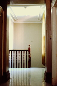
Slide - Kew Post Office, 1980
A civic campaign for new public offices developed in Kew in the 1880s. After much deliberation, the location chosen was the junction of Bulleen and Cotham Roads. The buildings were designed by George Watson and John Henry Harvey, architects within the Department of Public Works (Victoria). Building was commenced in 1887, and after one year, the buildings were opened. The Post Office was transferred to the new Commonwealth Government in 1901. The Police Station and Court House, sold by the Victorian Government to the City of Boroondara in 2007, are now a community cultural centre and performing arts venue.The buildings were listed on the Victorian Heritage Register Register (HO885) in 1991. They are historically and architecturally significant to the State of Victoria because Watson and Harvey's designs exhibit diversity in integrating civil offices, they accommodate the apex of road junctions, and they demonstrate a departure from the contemporaneously favoured High Victorian Classical to the Queen Anne style in the design of civic buildings. 35mm colour transparency of the first floor landing and staircase in the Kew Post Office at the corner of High Street and Cotham Road. The building is a significant example of the English Queen Anne Revival style. The photographs were taken by John Coghlan in May 1980 while it was still a functioning post office to support his written report: ‘The functional planning design, building materials and construction methods of the Kew Post Office.’ kew post office, khs - slides, new public offices -- kew (vic.), architectural styles -- english queen anne revival -
 Kew Historical Society Inc
Photograph - High Street, Kew, 1960-65
The borders of the main components of Kew and Kew East have not always conformed to current boundaries. In the past this photograph has been labelled as East Kew, whereas for most of the twentieth century the site has been within Kew's borders. The purpose of the photograph is unrecorded yet it has value in that it shows those businesses who occupied this site in Kew during the early 1960s.This small photograph is significant as it shows the location of and building used by WD Vaughan, former Mayor of Kew who was a successful newspaper proprietor in Melbourne.Small polaroid colour positive of High Street in Kew, probably in the 1960s. From left we can see the brick viaduct covering the tracks of what was once the Outer Circle Railway. Behind this brick wall, Dunnings Timber Yard was situated. At the end of the walls of the viaduct there is an entrance to a walkway [now the Anniversary Trail], which once provided access to Windsor Avenue, and also to the East Kew Station (now demolished and part of the Outer Circle Railway Reserve). On the other side of this walkway is a cream brick building (demolished) occupied at this time by WD Vaughan Pty Ltd, printer and publisher of the Kew Advertiser (newspaper). Stretching behind the brick facade is an extensive building that must have housed the printing works. Beside Vaughan's, there is a large building (demolished) housing at that time an estate agent named AJ Kennedy. This area is now separated by kerbing.High St East Kew / Corner of Harp Rd. / Looking South -
 Kew Historical Society Inc
Photograph - 'Butleigh Wooton', 867 Glenferrie Road, John T Collins, 1979
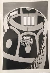
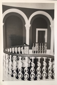
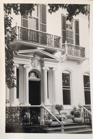
in 1882 Thomas Maidment paid the Society of Jesus £5,750 for nine allotments along Barkly Road (now Glenferrie Road). Maidment, who had arrived in Australia from the Glastonbury district in England in 1858, owned and managed a number of sheep stations in Victoria and subsequently became an '... eminently respectable ...' member of District society. In 1883 the Rate Books list Maidment's land in Barkly Road as the 'Buxton Hill Estate' and it was given an N.A.V. of £90, while in the following year his property attracted an N.A.V. of £160, suggesting that substantial improvements were taking place. Maidment's two-storey mansion, named 'Butleigh Wooton' after his birth-place in England, was completed in 1885 and was given an initial N.A.V. of £420. While Maidrnent is recorded as the owner of the building until at least 1896, Jane Maidment, his wife, continued the family ownership of the twenty-six roomed house with its extensive grounds until at least 1910. (Sanderson P. City of Kew Urban Conservation Study Vol 2)Butleigh Wooton is a substantial two storeyed house built in the Italianate style common in the 1880s. Its walls are rendered and it has limited applied decoration that includes brackets to the eaves line and engaged ionic columns under a broken pediment over the front entrance. The bowed window unit is of particular distinction and is not at all typical of this type of building. This interior by John T Collins is a view of the staircase from the first floor landing. (Sanderson P. City of Kew Urban Conservation Study Vol 2)Reverse: "JOHN COLLINS / 11 Anderson Road / Hawthorn East, 3123 / Film 395 Exposure 27A / Kew / Butleigh Wooton / Looking down on stairs / 8-4-79thomas maidment, butleigh wooton, 867 glenferrie road -- kew (vic.) -
 Kew Historical Society Inc
Photograph - 'Butleigh Wooton', 867 Glenferrie Road, John T Collins, 1979
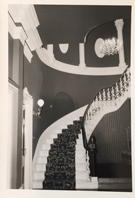
in 1882 Thomas Maidment paid the Society of Jesus £5,750 for nine allotments along Barkly Road (now Glenferrie Road). Maidment, who had arrived in Australia from the Glastonbury district in England in 1858, owned and managed a number of sheep stations in Victoria and subsequently became an '... eminently respectable ...' member of District society. In 1883 the Rate Books list Maidment's land in Barkly Road as the 'Buxton Hill Estate' and it was given an N.A.V. of £90, while in the following year his property attracted an N.A.V. of £160, suggesting that substantial improvements were taking place. Maidment's two-storey mansion, named 'Butleigh Wooton' after his birth-place in England, was completed in 1885 and was given an initial N.A.V. of £420. While Maidrnent is recorded as the owner of the building until at least 1896, Jane Maidment, his wife, continued the family ownership of the twenty-six roomed house with its extensive grounds until at least 1910. (Sanderson P. City of Kew Urban Conservation Study Vol 2)Butleigh Wooton is a substantial two storeyed house built in the Italianate style common in the 1880s. Its walls are rendered and it has limited applied decoration that includes brackets to the eaves line and engaged ionic columns under a broken pediment over the front entrance. The bowed window unit is of particular distinction and is not at all typical of this type of building. This interior by John T Collins is a view of the staircase from the first floor landing. (Sanderson P. City of Kew Urban Conservation Study Vol 2)Reverse: "JOHN COLLINS / 11 Anderson Road / Hawthorn East, 3123 / Film 395 Exposure 21A / Kew / Butleigh Wooton / Staircase / 8-4-79thomas maidment, butleigh wooton, 867 glenferrie road -- kew (vic.), john t collins -
 Kew Historical Society Inc
Photograph - 'Butleigh Wooton', 867 Glenferrie Road, John T Collins, 1979
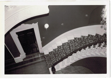
in 1882 Thomas Maidment paid the Society of Jesus £5,750 for nine allotments along Barkly Road (now Glenferrie Road). Maidment, who had arrived in Australia from the Glastonbury district in England in 1858, owned and managed a number of sheep stations in Victoria and subsequently became an '... eminently respectable ...' member of District society. In 1883 the Rate Books list Maidment's land in Barkly Road as the 'Buxton Hill Estate' and it was given an N.A.V. of £90, while in the following year his property attracted an N.A.V. of £160, suggesting that substantial improvements were taking place. Maidment's two-storey mansion, named 'Butleigh Wooton' after his birth-place in England, was completed in 1885 and was given an initial N.A.V. of £420. While Maidrnent is recorded as the owner of the building until at least 1896, Jane Maidment, his wife, continued the family ownership of the twenty-six roomed house with its extensive grounds until at least 1910. (Sanderson P. City of Kew Urban Conservation Study Vol 2)Butleigh Wooton is a substantial two storeyed house built in the Italianate style common in the 1880s. Its walls are rendered and it has limited applied decoration that includes brackets to the eaves line and engaged ionic columns under a broken pediment over the front entrance. The bowed window unit is of particular distinction and is not at all typical of this type of building. This interior by John T Collins is a view of the staircase from the first floor landing. (Sanderson P. City of Kew Urban Conservation Study Vol 2)Reverse: "JOHN COLLINS / 11 Anderson Road / Hawthorn East, 3123 / Film 395 Exposure 21A / Kew / Butleigh Wooton / Staircase looking up to dome / 8-4-79thomas maidment, butleigh wooton, 867 glenferrie road -- kew (vic.), john t collins -
 Kew Historical Society Inc
Photograph - 'Butleigh Wooton', 867 Glenferrie Road, John T Collins, 1979
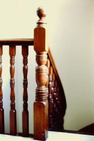
in 1882 Thomas Maidment paid the Society of Jesus £5,750 for nine allotments along Barkly Road (now Glenferrie Road). Maidment, who had arrived in Australia from the Glastonbury district in England in 1858, owned and managed a number of sheep stations in Victoria and subsequently became an '... eminently respectable ...' member of District society. In 1883 the Rate Books list Maidment's land in Barkly Road as the 'Buxton Hill Estate' and it was given an N.A.V. of £90, while in the following year his property attracted an N.A.V. of £160, suggesting that substantial improvements were taking place. Maidment's two-storey mansion, named 'Butleigh Wooton' after his birth-place in England, was completed in 1885 and was given an initial N.A.V. of £420. While Maidrnent is recorded as the owner of the building until at least 1896, Jane Maidment, his wife, continued the family ownership of the twenty-six roomed house with its extensive grounds until at least 1910. (Sanderson P. City of Kew Urban Conservation Study Vol 2)Butleigh Wooton is a substantial two storeyed house built in the Italianate style common in the 1880s. Its walls are rendered and it has limited applied decoration that includes brackets to the eaves line and engaged ionic columns under a broken pediment over the front entrance. The bowed window unit is of particular distinction and is not at all typical of this type of building. This interior by John T Collins is a view of the staircase from the first floor landing. (Sanderson P. City of Kew Urban Conservation Study Vol 2)Reverse: "JOHN COLLINS / 11 Anderson Road / Hawthorn East, 3123 / Film 395 Exposure 21A / Kew / Butleigh Wooton / Railing at head of stairs / 8-4-79thomas maidment, butleigh wooton, 867 glenferrie road -- kew (vic.), john t collins -
 Kew Historical Society Inc
Photograph - 'Butleigh Wooton', 867 Glenferrie Road, John T Collins, 1979
in 1882 Thomas Maidment paid the Society of Jesus £5,750 for nine allotments along Barkly Road (now Glenferrie Road). Maidment, who had arrived in Australia from the Glastonbury district in England in 1858, owned and managed a number of sheep stations in Victoria and subsequently became an '... eminently respectable ...' member of District society. In 1883 the Rate Books list Maidment's land in Barkly Road as the 'Buxton Hill Estate' and it was given an N.A.V. of £90, while in the following year his property attracted an N.A.V. of £160, suggesting that substantial improvements were taking place. Maidment's two-storey mansion, named 'Butleigh Wooton' after his birth-place in England, was completed in 1885 and was given an initial N.A.V. of £420. While Maidrnent is recorded as the owner of the building until at least 1896, Jane Maidment, his wife, continued the family ownership of the twenty-six roomed house with its extensive grounds until at least 1910. (Sanderson P. City of Kew Urban Conservation Study Vol 2)Butleigh Wooton is a substantial two storeyed house built in the Italianate style common in the 1880s. Its walls are rendered and it has limited applied decoration that includes brackets to the eaves line and engaged ionic columns under a broken pediment over the front entrance. The bowed window unit is of particular distinction and is not at all typical of this type of building. This interior by John T Collins is a view of the staircase from the first floor landing. (Sanderson P. City of Kew Urban Conservation Study Vol 2)Reverse: "JOHN COLLINS / 11 Anderson Road / Hawthorn East, 3123 / Film 395 Exposure 21A / Kew / Butleigh Wooton / Entrance / 8-4-79thomas maidment, butleigh wooton, 867 glenferrie road -- kew (vic.), john t collins -
 Surrey Hills Historical Society Collection
Map, Contour map of Surrey Hills showing potential sites for the Telecom Tower
The PMG / Telecom / Telstra tower was built in 1961-1963 as a relay station to support television and radio links between city and regional broadcasting stations. The tower itself was 45 m in height with a 2 storey building for equipment and staff surrounded by garden. From the beginning it was opposed by local residents. The location is said to be the second highest site in Melbourne, sometimes described as Delaney's Hill.Two A3 photocopied sheets of a map showing part of Surrey Hills, roughly between Windsor Crescent and Belmont Street (north / south) and Standard Avenue and Balmoral Crescent (east / west). The map shows contour lines and house sites, 16 of which are numbered. One sheet has been inscribed in top RH corner with notes regarding the significance of the numbers."Contour map of potential sites / for the telecommunications tower which / was eventually sited at 2. / Jock Campbell OBE was our neighbour / at 4 Theodore St when we moved into / the area in 1984. He was responsible in his / job at the PMG in deciding on the /site of the tower - Note site 5 was / behind his (& our) house. / Jack ended his career as Deputy Director / of the PMG. He sat on international committees / after WW2 to decide the split of the electronic / spectrum for radio, TV etc. / His group developed a "mobile phone" using / fixed towers but the phone was a truck full of gear."contour map, telecom tower, maps, jock campbell, john duncan campbell -
 Sunbury Family History and Heritage Society Inc.
Photograph, c 1900s
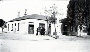
The building is the Sunbury Post and Telegraph Office and residence, which was built on the corner of Brook and Evans Street in 1892. Prior to that time the postal service ion Sunbury was conducted at the railway station. Over the years changes and extensions have taken place to the building to accommodate it for modern postal delivery practices although it still operates from the same site.The Sunbury Post Office has operated in a building on the same site since 1892 despite many changes and extensions made to the building, which included the demolition of the residence attached to the original building.A black and white photograph of Victorian style brick building with a slate roof with 3 chimneys and surrounded by a white picket fence. Two men are standing by a ladder on the LHS of the image. sunbury, sunbury post office, post and telegraph offices -
 Sunbury Family History and Heritage Society Inc.
Photograph, c 1940s
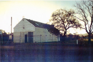
The building was the former Sunbury Fire Station. It was in Evans Street on the site where the shopping square has been built. Mount Holden can be seen in the background. A newer building was built for the CFA on the opposite side of Evans Street and closer to Macedon Street. As the shopping centre expanded and Sunbury grew, the CFA moved from the town centre to a site in Jackson Street and another one in Elizabeth Drive.Over the years the CFA has played an important role in numerous fire fighting activities over summer months.A scanned coloured photograph with a fine white border of an old weatherboard building with a metal roof by an unmade roadway. A hill is in the background and two bare trees are growing near the building.sunbury cfa. -
 Sunbury Family History and Heritage Society Inc.
Photograph, Royal Hotel, Pre 1936
The hotel in the photograph is the original single storey Royal Hotel with its corner entrance. It stood on the south -east corner of Evans and Brook Streets in Sunbury. The original building was damaged by fire in 1936 and a two storey red brick building replaced it on the original site with the hotel entrance facing onto Brook Street. The hotel is in close proximity to the railway station so it was able to offer accommodation to travellers visiting the Asylum.The Royal Hotel is one of two surviving hotels built in Evans Street. Originally there were four hotels built between Station and Brook Streets along Evans Street.A non-digital black and white photograph of a white single story hotel building showing the original corner entrance and three men standing beside it in the street. There are two other entrances on each side and three windows down one side. The iron clad roof has three chimneys.royal hotel, sunbury, hotels, brook street, evans street -
 Sunbury Family History and Heritage Society Inc.
Photograph, Sunbury News Office
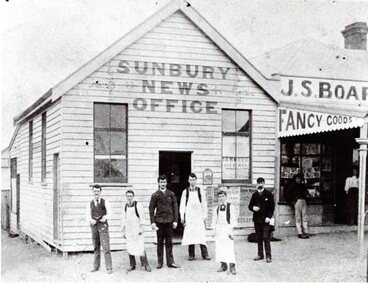
The Sunbury News Office was established by the Boardman family initially in Brook Street closer to the station. In 1880 Arthur Boardman opened a bookshop and news agency and in 1882, he printed the first issue of the Sunbury News.The building was on the SW corner of Brook and O'Shanassy Streets. Members of the Boardman family also ran the adjacent business. The Sunbury News was the local paper for residents until the late 1960s A non-digital black and white photograph with a cream border of a weatherboard news office building with six men standing the front. Three of the men are wearing white aprons. An attached building with a verandah is on the RHS of the office building.sunbury news, arthur boardman, brook street, o'shanassy street -
 Sunbury Family History and Heritage Society Inc.
Photograph, Royal Hotel
The two storey building in the photograph is the Royal Hotel. The original single storey hotel was damaged by fire in the 1930s so the double storey red brick building replaced it on the same site, which is at the intersection of Evans and Brook Streets. For many years the MIllett family owned and ran the hotelThe Royal Hotel is one of four hotels that operated in Evans Street between Station and Brook Streets. Only two of those hotels are operating on their original sites. The other two have been demolished and replaced with retail businesses.An enlarged black and white non-digital photograph with a narrow cream border of a streetscape of an intersection with a two storey brick building on one corner and cars park by the kerb outside the building.royal hotel, millett family, evans street, brook street, hotels -
 Sunbury Family History and Heritage Society Inc.
Photograph, Sunbury Post Office
The Sunbury Post Office with a residence pictured in the image was the first official post office building in the town. It opened on the corner of Brook and Evans Streets in 1892. Prior to that time postal services were conducted in an office at Sunbury Railway Station. Although the present day post office is still on the Brook-Evans Streets corner, the building has undergone many changes in services and appearances over the years. Like many country towns, the post office offered many services to the residents over the years. short message has been written on the back to a person in Stirling WA.sunbury post office, sunbury railway station, brook street, evans street, post offices -
 Sunbury Family History and Heritage Society Inc.
Photograph
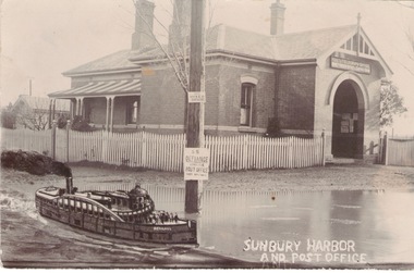
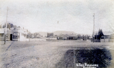
The post card is an early view of the intersection of Brook and Evans Street looking west and towards Sunbury Station. Mount Holden is in the distance. Chris Christianson's shop is on the LHS of the picture with the post office on the RHS. This image is an early view of Sunbury town centre with the railway station and post office. Like many country towns of this era, The roads have been formed but not surfaced. A sepia photograph in post card format of a view of a town centre showing an intersection and some small buildings with a hill in the distance.TO THE RAILWAY/SUNBURYbrook street, evans street, sunbury railway station, christianson, chris. -
 Sunbury Family History and Heritage Society Inc.
Post Card, In and around Sunbury with Greeting
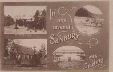
... Sunbury Railway station. The buildings and places featured ...The post card is one of a set that were produced by Chris Christainsen, who had a pharmacy in Sunbury and was also a photographer. The four photos featured on the card are the Rupertswood Mansion, St Mary's Church of England, Jacksons Creek in floods ands Sunbury Railway station.The buildings and places featured on the card are of historical significance in the Sunbury town precinct. A post card with four sepia photographs of interesting sites which can be seen in the Sunbury township. IN AND AROUND SUNBURY WITH GREETING. christainsen, chris., rupertswood mansion, st. mary's church of england., jacksons creek, sunbury railway station -
 Sunbury Family History and Heritage Society Inc.
Photograph, c.1910
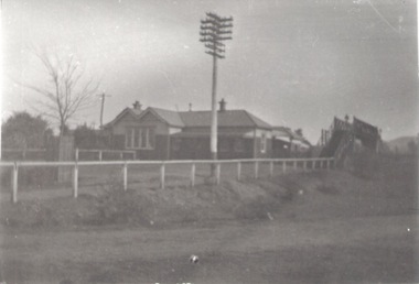
The building in the photograph is the Sunbury Railway Station in Brook Street and before it underwent renovations and externaL changes.The establishment of the railway in Sunbury in 1859 was an important development in the town's history and fore the Bendigo regional rail network.A black and white photograph of a weatherboard building behind a post and rail fence with a tall power pole in front of the building. A roadway is in front of the building.sunbury railway station -
 Sunbury Family History and Heritage Society Inc.
Photograph, 2000
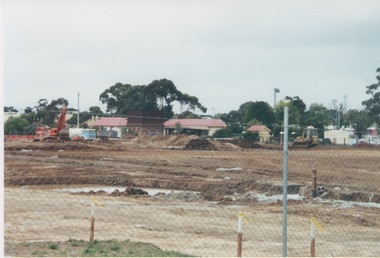
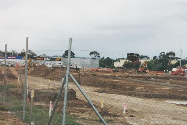
Excavation work to remove the grasslands and trees on the railway land on the west side of the Sunbury Station to make way for commercial development on that side of the line.A coloured photograph of excavation work in operation on land which has cyclone fencing around its perimeter. There are buildings in the middle distance beyond the work site.sunbury railway station -
 Sunbury Family History and Heritage Society Inc.
Photograph, 13 April 2000
In 2000 work commenced on the further development of railway land on the west side of Sunbury station for the construction of commercial and entertainment facilities. Prior to this time the land had been undeveloped and was often used to accommodate visiting circus troupes. Cereal storage silos also occupied this area for some time. The development of this area has been a reflection of the rapid expansion of settlement within Sunbury and surrounding areas that occurred during the early years of the twentieth century.A coloured photograph of a fenced off area undergoing development with earthmoving equipment and trucks in operation and some commercial buildings visible in the middle distance.sunbury railway station -
 Sunbury Family History and Heritage Society Inc.
Photograph, c 1970s
The photograph is an image of Sunbury Railway Station taken in the 1970s before it underwent refurbishment and extensions in 1993 and the establishment of its surrounding garden which the Sunbury Garden Club maintain.A coloured photograph of a weatherboard building with two large peppercorn trees growing in front of it behind a low post and rail fence. sunbury railway station, brook street -
 Sunbury Family History and Heritage Society Inc.
Photograph, 25th July 1995
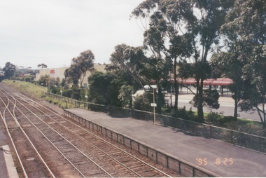
The photograph of Sunbury Station was taken from the pedestrian bridge and is looking north to take in the Sunbury Square shopping centre buildings and the bus terminal which are on the Platform 1 or east side of the station.During the 1990s much development took place in Sunbury and the station precinct became a commercial hub.A coloured photograph of a railway station and a Coles Supermarket in the middle distance as well as a bus terminal. -
 Sunbury Family History and Heritage Society Inc.
Photograph, 25th
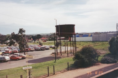
The photograph of Sunbury was taken from the pedestrian bridge at the railway station and is looking NW to Horne Street and beyond. The water tower in the foreground was used to pump water into the steam train engines. Then commercial development on the site was built shortly before this photograph was taken.A coloured photograph of an elevated view of Sunbury with a metal water tower in the foreground and a car park with commercial buildings in the middle distance.sunbury, sunbury railway station, horne street -
 Sunbury Family History and Heritage Society Inc.
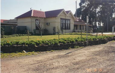
Photograph, 15th August 1995
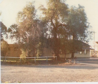
The house was the former station master's residence. When the photograph was taken it served as a restaurant. In the late 1990s it was demolished to make way for larger commercial development.The former stationmaster's residence was one of the important buildings in Sunbury.A coloured photograph of a cream weatherboard house with light green trims surrounded by a garden. Four cars are parked outside the house.sunbury railway station, stationmaster's residence, brook street -
 Sunbury Family History and Heritage Society Inc.
Photograph, 15th
In 1993 Sunbury Railway Station underwent refurbishment and with some extensions added to the existing building. The Sunbury Garden Club undertook the task of constructing the garden on the east side of the station. The photograph was taken two tears after the completion of the work. A coloured photograph of a garden in front of a weatherboard railway station with a gravel pathway in the foreground.sunbury railway station -
 Sunbury Family History and Heritage Society Inc.
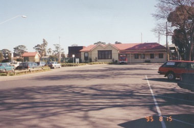
Photograph, 25th August 1995
This view of Sunbury Railway Station was taken from the corner of Brook and Evans Streets two years after the station underwent refurbishment and extensions and a carpark was constructed adjacent to the station. The Sunbury & District Heritage Association Inc. has a photograph P0663 of the station taken a century ago from the same place, when Sunbury was a small country town. The contrast between the two images is interesting. A coloured photograph of a streetscape with a weatherboard building in the middle distance,sunbury railway station, brook street -
 Sunbury Family History and Heritage Society Inc.
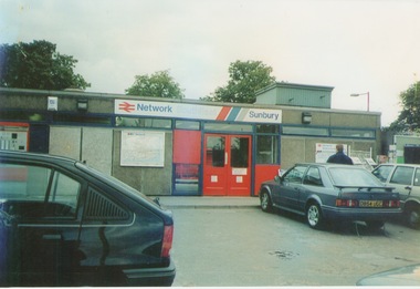
Photograph, September 1996
The photograph shows the railway station at Sunbury in Surrey in the United Kingdom. The town of Sunbury in Victoria was named after the English township of Sunbury-on-Thames in Middlesex by the Jackson Brothers who took up land in Sunbury, Victoria. The area was originally known as Koora Kooracup by the Wurundjeri people.Sunbury in Victoria like many other settlements in Australia were given names of towns in the United KingdomA coloured photograph of a railway station with three cars parked outside the building, which has grey walls and scarlet and blue trims. There are framed maps and notices on the exterior walls. -
 Sunbury Family History and Heritage Society Inc.
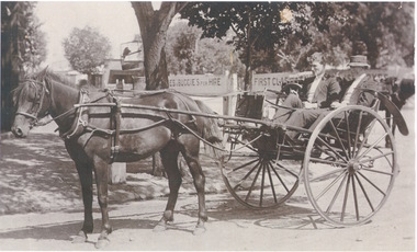
Photograph, c1900s
The two men in the curricle were in Brook Street outside Sunbury Railway Station.Before the advent of motor transport and buses, passengers from the train were taken by horse drawn vehicles to their destinations. An area was set aside at the station where the horses and vehicles waited for trains to arrive.A sepia photograph of two men seated in a stationary horse -drawn curricle beside a plantation area. There are two signs advertising horses and buggies for hire and some buildings are visible in the distance.curricles, brook street, sunbury, sunbury railway station -
Clunes Museum
Photograph - PHOTOGRAPHS
.1 The netball court in the photo was where "Collins Place", Fraser Street, Clunes is now located .3 the warehouse/Clunes Museum building at 36 Fraser Street, Clunes, was a former freezing worksPhotocopies of photographs .1 2 copies of girls playing netball .2 A streetscape of Fraser Street, Clunes .3 Del Mayberry (nee Campbell) and friend. The building that is now the warehouse/Clunes Museum is in the background of this photo, the building was a former freezing works .4 Jean Harling (nee Campbell) and male friend, outside The Club Hotel, Fraser Street, Clunes .5 Landscape of Clunes looking towards Station Flat Road. Port Phillip Mine is in the backgroundcampbell, netball, mayberry, harling