Showing 2475 items matching " township"
-
 Eltham District Historical Society Inc
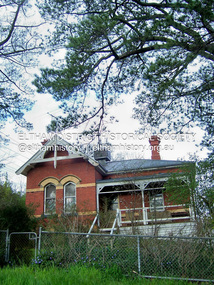
Photograph - Digital Photograph, Marguerite Marshall, Former Head Teacher's residence, Eltham Primary School, Dalton Street, Eltham, 7 September 2008
Built in 1891 for Head Teacher John Brown. His predecessor and the school's first Head Teacher, John Clark, lived in his own house 'Shoestring' in Metery Road, adjacent to the school. At the time of this photograph, the building was being used for before and after school care. Its present-day (2023) use is for school administration offices. Covered under Heritage Overlay, Nillumbik Planning Scheme. Published: Nillumbik Now and Then / Marguerite Marshall 2008; photographs Alan King with Marguerite Marshall.; p49 The former head teacher’s residence on 690 Main Road, was built in 1891 for the head teacher, John Brown. His predecessor David Clark lived in his own house known as Shoestring at Metery Road, possibly built in the late 1850s. With the school, Wingrove and Jarrold Cottages, it makes up the original Eltham township south of Dalton Street’s only group of 19th century buildings. The two Monterey Pines were popular vegetation in the late 19th and early 20th centuriesThis collection of almost 130 photos about places and people within the Shire of Nillumbik, an urban and rural municipality in Melbourne's north, contributes to an understanding of the history of the Shire. Published in 2008 immediately prior to the Black Saturday bushfires of February 7, 2009, it documents sites that were impacted, and in some cases destroyed by the fires. It includes photographs taken especially for the publication, creating a unique time capsule representing the Shire in the early 21st century. It remains the most recent comprehenesive publication devoted to the Shire's history connecting local residents to the past. nillumbik now and then (marshall-king) collection, dalton street, eltham, eltham primary school, headmaster's residence, main road, state school no. 209 -
 Bacchus Marsh & District Historical Society
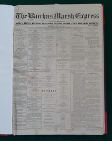
Newspaper, George Lane, Bacchus Marsh Express, July 1866
The Bacchus Marsh Express was a weekly newspaper first published in July 1866. It was produced in the Victorian town of Bacchus Marsh and was distributed in that township and the surrounding district. The original title was "The Bacchus Marsh Express : and General Advertiser for Ballan, Melton, Myrniong, Blackwood, Gisborne, Egerton and Gordon Districts". There were numerous variations to the name of this newspaper over the next 100 years but it usually retained the word 'Express' as part of its title. In September 2010 the word Express disappeared from the title and it became known as the Moorabool Weekly which then merged with some other newspapers over the next few years. For over 100 years the Crisp family owned or were associated with the production of the Express. By 22 February 1984 Syme Community Newspapers had taken over the Express. This entity was later renamed Fairfax Community Newspapers and continued to publish the Express until the disappearance of the name 'Express' altogether at the begining of September 2010. The last issue with the word 'Express' in the title being published on 31 August 2010.This is the first local Bacchus Marsh newspaper that continued to be published over a significant period of time. After beginning July 1866 it continued to be published weekly until the last issue on the 31 August 2010 was published. Nearly all published editions of the Express have been preserved. Issues No.1 and No.2, 7 and 14 July are not extant. The earliest known issue in existence is No.3, 21 July, 1866. Original copies from 21 July 1866 until 31 August 2010 are held by the Bacchus Marsh and District Historical Society.Bound and unbound newspaper issues, microfilm, and CD-ROM. printers, newspapers bacchus marsh, bacchus marsh express, christopher crisp 1844-1915, crisp family bacchus marsh -
 Marysville & District Historical Society
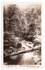
Postcard (item) - Black and white postcard, Rose Stereograph Company, Talbot Drive, Marysville, Vic. No. 3, The Taggerty River, 1913-1967
A postcard in a series produced by the Rose Stereograph Company in Victoria, Australia as a souvenir of Marysville.A black and white photograph taken along Lady Talbot Drive, Marysville, in Victoria, of the Taggerty River. Lady Talbot Drive is a 24 kilometer scenic rainforest car journey which passes a number of walks and waterfalls in the Yarra Ranges National Park. Lady Talbot Drive is named after Lady Sarah Elizabeth, the wife of Sir Reginald Talbot, who was the Governor of Victoria from 25th April, 1904 to 6th July 1908. This postcard was produced by the Rose Stereograph Company as a souvenir of Marysville.POST CARD The "Rose " Series/ De Luxe A Real Photograph/ Produced in Australia Published by the Rose Stereograph Co./ Armadale, Victoria. Dear John,/ I am writing this note in my room/ at Mt. Kitchener House before sallying forth for/ dinner. Unfortunately space does not permit/ me to tell you much, but I must let you know/ that yesterday morning (Monday), a blanket of/ snow covered the township of Marysville to a/ depth of three or four inches. Further up, near/ Keppel's Lookout, which we visited yesterday, it/ was nearly a foot deep everywhere, and it snowed/ the whole time we were walking./ Will tell you all later, your friend, Billtalbot drive, marysville, victoria, taggerty river, p. 2308, rose series postcard, postcard, souvenir, sir reginald talbot, lady sarah elizabeth talbot -
 Melton City Libraries
Document, Darlingsford land title, 1863
Thomas Bell Darling purchased 176 acres from the Toolern Creek to Ferris Road. A house and bluestone barn/stables were built. The property was owned by Ralph Parkinson, followed by Richard Manning. SUMMARY – Darlingsford – Auction 1910 Darlingsford – Auction 1910 Melton Express October FRIDAY, October 28th At Three O’Clock At the RAGLAN HOTEL, MELTON SUBDIVISIONAL SALE of the DARLINGSFORD ESTATE, MELTON. Having a long frontage to the TOOLERN CREEK. In the Estate of the late RICHARD MANNING’ W. S. KEAST and L.A. FAIRBAIRN & CO., Auctioneers (in conjunction). Have received instructions from R.F. and J.L. Robertson, executors of Richard Manning deceased to offer by Public Auction, property almost adjoining Melton township, and having a frontage to the Toolern Creek, subdivided in to four lots as under:- Lot 1. – The homestead block containing 176 acres, being portion A, section 11, parish Kororoit together with the improvements, which consist of a 6-roomed stone house, milking shed, dairy, U.G. tank. Lot 2 – 177 acres 2 rood 23 perches, being Crown portion B of section 11 parish Kororoit. This block adjoins the homestead and is partly fenced. Lot 3 – 187 acres, Crown allotment C, section 11, parish Kororoit. adjoining the above lot. Lot 4 - 157 acres 1 rood 27 perches, being Crown allotment 9, section 12, parish of Kororoit. This block is only divided from the above lots by road, and adjoining Messrs. McVean and Gaitskill’s properties. This is one of the best known properties in the Melton district as a cultivation an grazing form, and its close proximity to the township makes it a very valuable, and portion of which could be cut into township blocks and should command a ready sale. For absolute sale. Terms- one fifth cash, one fifth in eight years, balance in 7 years with interest a the rate of 4 1/2 percent. Plan on application For further particulars apply W.S. KEAST, 610 Collins street, Melbourne; and L.A. FAIRBAIRN & Co., St James-buildings, Williams street, or at Bacchus Marsh; and as to the title, Dugdale and Creber, St. James-buildings, William Street Melbourne. Express November 5, 1910 On Friday last, Mr W.S. Keast and Messrs L.A. Fairbairn & Co., in conjunction, offered at the Raglan the Manning Estate known as Darlingsford, comprising of 700 acres, divided into four lots. Lot 4 was submitted first and passed in at L8 per acre. Lot 1 was then put up and went up to L13 per acre, at which it was also passed in. Lot 3 was next offered, and there being no bid was also passed in. Lot 2 was not offered. Express March 18, 1911 The Manning Estate of Darlingsford 600 acres was sold to Mr. Ernie for an undisclosed price. Note: Map KOROROIT COUNTY OF BOURKE Crown Grant Section 11 Portion A Thomas. B. Darling 176 . 0 . 0 acres on 29.3.1853 Lot 1 Portion B A. Russell 170 . 0 . 0 acres on 29.3.1853 Lot 2 Portion C Peter Inglis 176 . 0 . 0 acres on 29.3.1853 Lot 3 Section 12 Portion 3 P. Inglis 157 . 1 . 27 acres on 17.17.1863 Total 176 170 176 157. 1.27 679 . 1.27 acres November 5th 1910 On Friday night last Mr W S Keast and Messrs L A Fairbairn & Co, in conjunction offered at the Raglan Hotel the Manning Estate known as Darlingsford, comprising of 700 acres, divided into four Lots. Lot 4 was submitted first, and was passed in at L8.0.0. per acre. Lot 1 was then put up and went to L13.0.0. per acre at which it was passed in. Lot 3 was next offered, and then Lot 3 was next offered, and then being no bid was passed in. Lot 2 was not offered. October 22nd Notice of sale. 700 acres of splendid land close to the railway station. Divided onto 4 Lots 3 of which are maiden land and the whole of the acres is chocolate soil. No 1 Lot belonged to the late Mr Ralph Parkinson, and for years was liberally supplied with manure and crushed bones, and is capable of producing many crops.. The property being sold to wind up the Estate. Gisborne Gazette Friday December 17th 1911 Mr Sharp has sold his farm at the back of the township to Mr. E Barrie; price L15/10/ per acre. Agreement between Thomas Bell Darling and Ralph Parkinsonlocal identities -
 Federation University Historical Collection
Book, Memoirs of the Geological Survey of Victoria No 14 The Ballarat Goldfields, 1923, 1923
William Baragwanath was educated at the Ballarat School of Mines, obtaining a Geology Certificate in 1911. After further study he went on the become Secretary for Mines, and Chief Mining Surveyor. Baragwanath was a Councillor of the Ballarat School of Mine from 1916 to 1950.Pink covered foolscap book of 257 pages and 32 maps and plans by William Baragwanath. Contents include topography, physiography, historical, geology, basalt, faults, dykes, minerals leads, alluvial mines, nuggets, structure of Ballarat West goldfields, structure of Ballarat East gold-field, quartz formation, indicators, defunct mines, existing mines, table of deepest shafts. Images include: section of the Ballarat Gold-Field, Dead HOrse Flat, lakes formed by Basalt Flows, Gong Gong Creek, Frenchman's Lead, Ballarat West Mines, LEases and positions of shafts (1857), puddling, White Horse Lead, Woah Hawp Canton, Ballarat Township mines, Sebastopol, syncline, Victoria United Line, First Chance Mine, Llanberris No 1 Mine, Saddle Reef, New Normanby Mine, Woah Hawp Canton Mine, South Star Mine, Sebastopol Plateau, south Woah Hawp Mine, Woah No. 2 Minegeology, geological survey no 14, ballarat, baragwanath, william baragwanath -
 Southern Sherbrooke Historical Society Inc.
Information Folder - St. Bartholomew's Anglican Church, Ferntree Gully and St. Thomas' Anglican Church, Upper Ferntree Gully
Information folder containing items pertaining to the history of St. Bartholomew's Anglican Church, Ferntree Gully and St. Thomas' Anglican Church, Upper Ferntree Gully. Contents: -letter, Bob Collie to Susan Heywood-Downard, dated 12 October 1995 -photo, Rev. W. M. Robertson -photo, "Rev. W. G. Thomas 1913-1918" -photo, "St. Bartholomew's/Ferntree Gully/Station St -Lower FTG/No longer there" -photo, aerial shot of Ferntree Gully township, "Mr Curlewis, Gacidal (?) St, North Bayswater. The clergy house is at the extreme RH of photo, on top of hill. It is no longer there on 'The Avenue'" -booklet, "The Anglican Church of St. Thomas, Upper Ferntree Gully. A Short Guide & brief history" by Brian Kennedy, June 1993 -booklet, "The Church of England, St. Bartholomew's Ferntree Gully Lower, St. Thomas', Ferntree Gully Upper. Combined Funds Canvass - 1957"st. bartholomew's anglican church, ferntree gully, st. thomas' anglican church, upper ferntree gully. -
 Wodonga & District Historical Society Inc
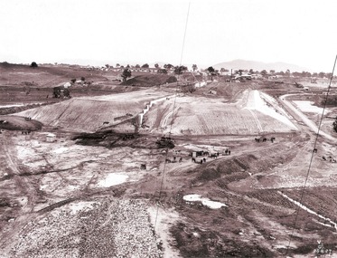
Album - Hume Reservoir Australia Album - Earth embankment on Victorian side from Top of Tail Tower Pillar, August 1927
This set of photos is from a leather bound album bearing the inscription "HUME RESERVOIR AUSTRALIA" plus 'The Rt. Hon. L. C. M. S. Amery, P. C., M .P.' all inscribed in gold. It was presented to The Rt. Hon. L. C. M. S. Amery, P. C., M. P, Secretary of State for Dominion Affairs on the occasion of his visit to the Hume Reservoir on 2nd November 1927. This album is of local and national significance as it documents the planning and development of the Hume Reservoir up to 1927. It was the largest water reservoir in the British Empire. The album records the pioneering engineering work that went into its construction.DEPARTMENT OF PUBLIC WORKS, N.S.W. RIVER MURRAY WATERS SCHEME. HUME RESERVOIR. 31. View from Top of Tail Tower Pillar - Earth Embankment, Victoria. This is a general view of the embankment which is being constructed by the Victorian Constructing Authority. The bank at its base is about 650 feet wide and it is about half its ultimate height. In the middle is the reinforced concrete core wall. At about the natural surface a tunnel for drainage and inspection purposes is built along the downstream side of the core wall but this cannot be seen. The Victorian workshops and township are located on the high ground beyond the embankment. The embankment curves round to the left at the side of the valley and will eventually block the gulley where the bushy tree stands. Access to one of the cuttings from which material is being got for the embankment is gained by means of this gulley at present. Part of another cutting may be seen on the right hand side at the back. August 1927.hume reservoir australia, river murray waters scheme, hume reservoir construction -
 Ballarat Heritage Services
Photograph - Digital photographs, L.J. Gervasoni, Wombat Hill Botanic Gardens 150 anniversary event Daylesford organiser Gael Shannon, 2013
The Wombat Hill Botanic Gardens 150 anniversary event organiser was Gael Shannon. The Daylesford Botanic Gardens are of historic, scientific (botanic), and aesthetic significance to the State of Victoria. The Daylesford Botanic Gardens are historically significant as a fine example of a regional botanic garden demonstrating the typical characteristics of a carriage drive, informal park layout, decorative structures and works such as the memorial tower, conservatory, rotunda, cascade and fernery, which contrasts with the open lawns planted with specimen trees, areas of intensive horticultural interest and close proximity to a township developed during the mid to late nineteenth century. The Daylesford Botanic Gardens are historically significant for the design input by noted landscape designer William Sangster, and for the survival of his 1884 plan, which is a rare example of a plan from this prolific garden designer. The Daylesford Botanic Gardens are of scientific (botanic) significance for the extensive conifer collection and cool climate plants. The Gardens contain an outstanding collection of conifers and other mature trees, many of which were donated by renowned botanist Ferdinand von Mueller. Significant trees include Pinus ponderosa (Western Yellow Pine), Pinus coulteri (Big Cone Pine), twoAbies nordmanniana (Caucasian Fir), Abies pinsapo, (Spanish Fir) and a Cedrus atlantica f. glauca(Blue Atlas Cedar), Pinus wallichiana (Bhutan Pine), Pinus pinaster (Maritime Pine), Sequoiadendron giganteum (Giant Redwood), (Monkey Puzzle) and Aesculus hippocastanum (Horse Chestnut), many the largest or finest examples in Victoria. Other outstanding trees include a Tilia cordata (Small-leaved European Linden), a row of Cupressus lusitanica (Mexican cypress), a Quercus robur (English Oak) planted in 1863, avenues of Dutch Elms and a rare Quercus leucotrichophora (Himalayan Oak). The Daylesford Botanic Gardens are of aesthetic significance as a rare example of a botanic garden spectacularly sited on an extinct volcanic cone which allows a panoramic view, aided by the 1938 Pioneers’ Memorial Tower, as well as vistas within and out of the gardens and from the township to the gardens. As the most prominent local landmark, the Garden’s vertical dominance in the landscape provides a dark contrast to the elms avenues, oaks and other deciduous species. (Heritage Victoria Register, )Four people photographed at the 150th anniversary event at the Wombat Botanic Gardens.victoria, 150, anniversary, botanic, gardens, wombat hill, botanic gardens, heritage, celebration, garden party, daylesford, people, crowd, community, organiser, tour, gael shannon, don henderson, wombat hill botanic gardens -
 Eltham District Historical Society Inc
Slide - Photograph, On the Eltham Road, Walter Withers (1906), Heidelberg School Artists Trail, Alistair Knox Park, Eltham, c.Nov. 2001
The Heidelberg School Artists Trail was established in about 1999 with about 52 signs across four local governemnt areas including Nillumbik and Banyule. It extends from Heidelberg through Eltham and Warrandyte and to the Dandenongs. It features signs depicting paintings of artists in the location in which they were painted. This one acknowledges "On the Eltham Road", 1906. Transcription of the text states: "In this cheerful rural landscape, Walter Withers has captured the spirit of early Eltham. Eltham was a quiet, sleepy village, where geese wandered up the main Road and the locals either walked or rode their horses or bicycles around the township. Walter Withers was known to load up his bicycle with his collapsible easel, folding stool, paint box, water bottle and canvases, and would head off for a day’s painting. He was also known for his walking, as was his family, and they became known as the ‘Walking Withers’ Part of a slide show presentation "A Trip Down the Diamond Creek" by Russell Yeoman to the Eltham District Historical Society meeting of 14 Nov. 200135mm colour positive transparency Mount - Black and Whiteeltham, alistair knox park, heidelberg school artists trail, on the eltham road, public art, sign, walter withers -
 Federation University Historical Collection
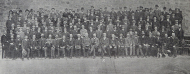
Book, Ballarat School of Mines Students and Australian Institute of Mining Engineers at the Central Mine, Broken Hill, 1906, 1906
Each year The Australian Insitutue of Mining Engineers held a meeting in an important mining district or township. In 1906, via the good offices of David Ham an invitation was extended to the Ballarat students to take part in a trip to Broken Hill, via Wallaroo and Moonta, and Port Pirie. They left the Ballarat station on Saturday May 19, 1906 aboard the Adelaide Express. The Ballarat party consisted of David Ham (Ballarat School of Mines Council Member); staff members Frederick J. Martell, A.D. Gilchrist, John Sutherland, A.E.C. Kerr, A. Garard and E.J. McConnon. The attending students were W.P. Avery, M. Boyer, M.H. Bade, E. Booth, E. Crossly, A. Cooper, G.H. Davenport, W.E. Figgis, R. Galloway, C. Hesselmann, H. Hawkesworth, M. McCallum, H.F. Owen, W. Pearce, W. Sayer, J. Sutherand, Arthur E. Tandy and H.C. Valentine. Students were also present from the Working Men's College (later RMIT), Bairnsdale School of Mines, Melbourne University and the Bendigo School of Mines. Members of Australian Institute of Mining Engineers and students from the Ballarat School of Mines at the Central Mine, Broken Hill. It is assumed the Ballarat School of Mines students are in the boater hats with the striped hat braid. ballarat school of mines, australian institute of mining engineers, central mine, broken hill, broken hill, visits, excursions, david ham, frederick j. martell, a.d. gilchrist, john sutherland, a.e.c. kerr, a. garard, e.j. mcconnon, w.p. avery, m. boyer, m.h. bade, e. booth, e. crossly, a. cooper, g.h. davenport, w.e. figgis, r. galloway, c. hesselmann, h. hawkesworth, m. mccallum, h.f. owen, w. pearce, w. sayer, j. sutherand, arthur e. tandy, h.c. valentine. -
 Orbost & District Historical Society
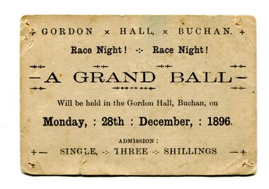
Document - ticket, 1896
Gordon Hall was the first public building in Buchan. European settlement first entered the area in October 1838 and Buchan station was established in January 1839. Free selection after 1868, and a township was proclaimed in 1873 taking its name from the station. The Grand ball was held on race night, Monday 28th December 1896 in the Gordon Hall at Buchan. From the estate of Elsie Cooke. Elsie Cooke was a librarian in Orbost for many years. She was the daughter of John Cooke early Brodribb settler. Elsie Cooke lived all her life in Gippsland,. She was born at Brodribb in 1895 and died in 1970, Elsie Cooke lived at Bruthen for a short time and, in 1937, moved to live with her aunt, Miss Jean Munro. Miss Cooke was Librarian at the Mechanics Institute for many years. Kindness and consideration for other were Miss Cooke’s attributes and she endeared herself to all who knew her. She was a loyal member of the Presbyterian Church and a stalwart of the Ladies’ Guild, an energetic worker for the Municipal Auxiliary and a member of the Red Cross. (ref. Mary Gilbert)This item reflects the recreational / social activities of a remote rural community. A public event such as a grand ball would have been a significant event on the calendar.Small, cream-coloured rectangular card with rounded edges and blank ink. Evidence of pin holes in each four corners and folds/signs of wear. Card is foxing and has small vertical tear in lower left quadrant.+ GORDON x HALL, x BUCHAN. + / Race Night! - Race Night! / A GRAND BALL / Will be held in the Gordon Hall, Buchan, on / Monday, : 28th : December, : 1896. / ADMISSION : / +- SINGLE, THREE SHILLINGS -+grand ball, 1896, gordon hall, buchan, elsie cooke -
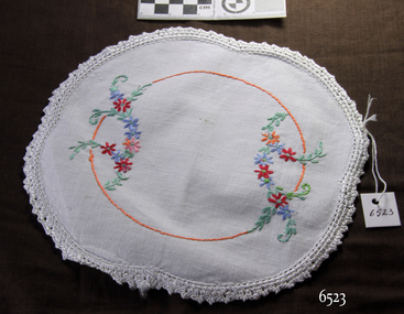 Flagstaff Hill Maritime Museum and Village
Textile - Doily, c. 1910
This doily is typical of items of household linen in popular use in the 19th and early-to-mid 20th centuries. It was a tradition for brides to have a 'glory box' containing linen and embroidered and crocheted articles to take to their new home. In the Words of donor, Betty Stone, … “These crocheted and embroidered articles cover a period of three generations- ie. Sarah (nee Chamberlain) Lees, Ann (nee Lees) Dale, and Daisy Elvena (nee Dale) Welsh. All three were accomplished needlewomen; also, both Sarah Lees (born 1844) and her daughter, Ann (b 1865) crocheted a wide variety of articles for use in their homes. A few examples of these items have survived the years.” (NOTE: For additional information please refer to my book Pioneer and Places- A History of Three Warrnambool Pioneering Families ie. Chamberlain, Dale and Lees families) SIGNIFICANCE This item is associated with the Warrnambool pioneer families of Chamberlain, Dale and Lees. These families are listed in the Pioneers' Register for Warrnambool Township and Shire, 1835-1900, published by A.I.G.S. Warrnambool Branch. The item is a fine example of early 20th-century needlework.This item is associated with the Warrnambool pioneer families of Chamberlain, Dale and Lees. These families are listed in the Pioneers' Register for Warrnambool Township and Shire, 1835-1900, published by A.I.G.S. Warrnambool Branch. The item is a fine example of early 20th-century needlework. Doily, ovate cotton fabric with embroidered flowers of orange, blue, pink and red flowers with greenery and an orange circle with a white crocheted edge. From the Chamberlain Dale Lees Collection,flagstaff hill, warrnambool, flagstaff hill maritime museum and village, great ocean road, chamberlain family, dale family, lees family, betty stone, warrnambool pioneer, warrnambool genealogy, wangoom, chamberlain dale lees collection, glory box, doily, embroidery, needlework, crochet, handmade, craft, manchester, linen, haberdashery -
 Otway Districts Historical Society
Minute Book, Beech Forest Football Club, Minutes, Balance Sheet, 1948-54, 1948
Beech Forest first entered the association prior to World War 1, playing in maroon and gold on a ground situated 200 metres north of the final ground. Little is known of the competition in those days. The Club reformed in 1921. Beech Forest changed its colours to Richmond colours and used a ground south of the township, now known as the Football Break Road in the Forest Commission pine plantation. In 1922 the site of the present ground had been purchased but it was 1929 before it was first used, and it was used every year, except 1953 when G. Bellchamber's paddock was used while major renovations were carried out on their home ground. It was in the same year, 1929, that they changed their colours yet again to the blue with white V colours, which they retained until the Club disbanded. Beech Forest won premierships in 1924 and 1940. In 1945 the Club reformed yet again to enter the Otway Association. They were successful in winning premierships in 1946, 1947, 1952 and 1953. Finally, in 1957, the Club disbanded to become part of the Otway Rovers Football Club.Beech Forest Football Club, (1) Annual Meeting and Ordinary Meeting Minutes, November 1948 - September 1952; (2) Annual Meeting and Ordinary Meeting Minutes March 1953 - April 1954, Statements of Receipts and Expenditure 1950 - 1952. 2x Exercise Book.Insert: Grounds used; Best and Fairest Players.beech forest; football; minutes; -
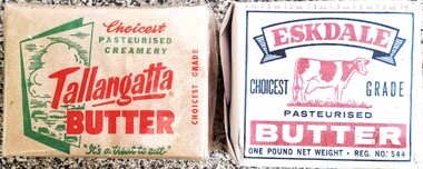 Wodonga & District Historical Society Inc
Domestic object - Butter packet - Eskdale and Tallangatta Butter Factories
Tallangatta Butter Factory The Tallangatta Butter Factory and Creamery Co. Ltd was established as a co-operative with application for shares closing on 19 December 1891. It was registered in February 1892 and notified in the Victorian Government Gazette. It was one of the first north eastern Victoria dairy co-operatives. The Upper Murray and Mitta Herald on Thursday 23 March 1905 recorded that advice had been received of the sale in London of a shipment of 191 boxes of sent via India. The sale fetched a price at 105 shillings per cwt (hundredweight). When the township of Tallangatta was moved due to the raising of the Hume Weir in 1956, a new factory was built at the new location. It continued to operate until 1959 when it merged with the Kiewa Butter Factory to become the North Eastern Dairy Company. In 1985 this organisation was taken over by the Murray Goulburn Co-operative Eskdale Butter Company. After the selling of shares to form a co-operative, The Eskdale Butter Factory was officially opened on Saturday 26 November 1904. It closed after a merger with Murray Goulburn in 1969.This item is representative of the dairy industry in North East Victoria.2 wrappers for butter produced in North East Victoria by the Tallangatta Butter Factory and the Eskdale Butter Factory and Creamery. Both wrappers are a single sheet of folded paper with coloured images and logos.dairy industry victoria, tallangatta butter factory, eskdale butter factory -
![Map, Liquidator's sale, 1896. [Woolpack Estate, Bacchus Marsh]](/media/collectors/5e461d8021ea67224c82f2a1/items/6779ee97032b72846b5995f2/item-media/6779ef33032b72846b599b30/item-fit-380x285.jpg) Bacchus Marsh & District Historical Society
Bacchus Marsh & District Historical SocietyMap, Liquidator's sale, 1896. [Woolpack Estate, Bacchus Marsh]
The Woolpack Estate was an area of land owned by various landowners in the Bacchus Marsh area since the early Colonial period of the 1840s. The area was located on the eastern side of the Bacchus Marsh township about 7 kilometers from the town. The Lerderderg River ran through part of the land and so did the Melbourne to Ballarat Road. The historic Woolpack Inn associated with James Crook was also located on this land. By 1896 150 acres of this land was under the control of liquidators for the Federal Bank of Australasia who instructed that the land be sub-divided and sold in lots by public auction. A successful sale was held on 24 June 1896. Most of the blocks of land were sold for higher than expected prices and most of the buyers were people from the town and district of Bacchus Marsh. The map includes various details about the land which is described on the map as an "important sale of rich alluvial irrigable flat land in the Bacchus Marsh Valley, and other properties". The auction was conducted by the local agents W. Anderson and Bence in conjunction with Pearce Brothers also of Bacchus Marsh.A single page paper map showing a plan of 150 acres of land from the Woolpack Estate to be sold in various lots in June 1896. Also shown on the map are lots for sale at Robinson's Farm on Coimadai Creek and allotments near Bacchus Marsh railway station, including lots on Government Road (East Maddingley Road), View Street and Government Road (Parwan Road). No scale provided. The map is pasted into a bound volume containing 76 maps or plans in total. High resolution digital image stored on BMDHS computer network. land sales bacchus marsh, bacchus marsh victoria maps, woolpack estate bacchus marsh victoria -
 Bacchus Marsh & District Historical Society
Map, Subdivision of the Manor House Property Bacchus Marsh c.1908
This land sales plan shows allotments of land offered for sale in the inner township area of Bacchus Marsh in 1908. The land put up for sale was from the estate of the late Mr and Mrs J.E. Crook. That being James Elijah Crook and his wife Harriet, (nee Athorn). The Crooks had been resident in Bacchus Marsh since the 1840s and were prominent members of the community. They were prominent in the business, social and civic affairs of the town and district. In the 1850s the Crooks acquired the Manor House and nearby land once owned by the Bacchus family. James Crook died in 1889. When Harriet Crook died in February 1908 their estate was offered for sale. This included the large stone home known as the Manor House and various parcels of land including around 50 allotments of land near the Manor House, bounded by Young, Lerderderg, Crook and Main Streets. Most of these allotments of land were sold in October 1908. The Manor House itself was passed in at the sale and continued to be owned by the Crook family for several decades after 1908.A single page map on a single page of a bound volume of maps. The map shows portions of land for sale from the subdivision of the Manor House property in Bacchus Marsh in 1908. The names of most of the buyers of the portions of land have been hand-written into the various allotments they purchased. The maps are pasted into a bound volume containing 76 maps or plans in total. High resolution digital image stored on BMDHS computer network. bacchus marsh victoria maps, land sales bacchus marsh, manor house bacchus marsh, crook family bacchus marsh -
 Bacchus Marsh & District Historical Society
Map, Atkins and Clarke Land Sale situate at Bacchus Marsh 1856 Copy 2
This plan of land allotments for sale indicates the property once owned by the Bacchus family in and around the township area of Bacchus Marsh. The Bacchus family sold their property in Bacchus Marsh to John Atkins and Robert Nalder Clarke in March 1851. Atkins and Clarke kept the property for a number of years until April 1856 when these allotments were put up for sale.This plan is almost identical to another copy held by the Bacchus Marsh and District Historical Society, VC Record 707, BMDHS collection). This plan, VC Record 452 Copy 2, contains a less detail than than VC Record 707 Copy 1. For example the selling agents and the surveyor who created the plan are not indicated on this copy of the plan. This copy of the plan does indicate the name Crook Street on the map. As the Crook family were the buyers of the Manor House property and surrounding land from Atkins and Clarke in 1856 it suggests that this copy is a later one of the earlier version. It is unlikely that the Crook family would have had the adjacent street named after them prior to purchasing the house and property. This is a very early land sales plan for the township of Bacchus Marsh and it therefore provides some clues as to how the early urban development of the township took place. Upon seeing the map in 1911 Bacchus Marsh Express newspaper editor Christopher Crisp wrote "The sale appears to have created the present township, which had a nucleus in earlier times further east", Express, 30 September, 1911, page 3. A single page paper map showing a portions of land available for sale in Bacchus Marsh in 1856. The subdivided land shown was owned by John Atkins and Robert Nalder Clarke, but previously owned by the Bacchus Family and was in and around their Manor House (Mansion) property in Bacchus Marsh.There are 5 portions of land further divided into numerous small portions. The land for sale is bounded by the present day streets of Main Street, Young Street, McFarland Street, Morton Streets, Crook Street, and part of the eastern section extends to the Lerderderg River. Scale: 4 chains to 1 inch. The map is pasted into a bound volume containing 76 maps or plans in total. High resolution digital image stored on BMDHS computer network. Plan of the first portion of land. The property of Messers Atkins and Clarke situate at Bacchus Marsh.land sales, land sales bacchus marsh, manor house bacchus marsh, crook family bacchus marsh -
![Scene on the Yarra, near Rourke's Bridge / [by] Nicholas Caire, circa 1876](/media/collectors/550653872162f11fb04854aa/items/5777571cd0cdd10a5c191a9c/item-media/57775788d0cdd10a5c193e0d/item-fit-380x285.jpg) Kew Historical Society Inc
Kew Historical Society IncPhotograph, Anglo-Australasian Photographic Company, Scene on the Yarra, near Rourke's Bridge, c. 1876
Nicholas Caire was born on Guernsey in the Channel Islands in 1837. He arrived in Adelaide with his parents in about 1860. In 1867, following photographic journeys in Gippsland, he opened a studio in Adelaide. From 1870 to 1876 he lived and worked in Talbot in Central Victoria. In 1876 he purchased T. F. Chuck's studios in the Royal Arcade Melbourne. In 1885, following the introduction of dry plate photography, he began a series of landscape series, which were commercially successful. As a photographer, he travelled extensively through Victoria, photographing places few of his contemporaries had previously seen. He died in 1918. Reference: Jack Cato, 'Caire, Nicholas John (1837–1918)', Australian Dictionary of BiographyAn original, rare photograph from the series 'Views of Victoria: General Series' by the photographer, Nicholas Caire (1837-1918). The series of 60 photographs that comprise the series was issued c. 1876 and reinforced a neo-Romantic view of the Australian landscape to which a growing nationalist movement would respond. Nicholas Caire was active as a photographer in Australia from 1858 until his death in 1918. His vision of the Australian bush and pioneer life had a counterpart in the works of Henry Lawson and other nationalist poets, authors and painters.Albumen silver photograph mounted on boardprinted in ink on support l.c.: SCENE ON THE YARRA, NEAR ROURKE'S BRIDGE. / COPYRIGHT REGISTERED. printed in ink on support reverse c.: VIEWS OF VICTORIA. / (GENERAL SERIES.) / No. 16. / SCENE ON THE YARRA, NEAR ROURKE'S BRIDGE. / The subject of the present illustration represents the New Bridge crossing the River Yarra on the road from / St. Huberts to the Native Station at Corranderrk, and to the township at Healesville. The river at this place abounds / with fish of a large description, which are caught by the Natives, frequently in considerable quantitities. printed in ink on support reverse l.c.l.: J.W. FORBES, Agent, printed in ink on support reverse l.c.: ANGLO-AUSTRALASIAN PHOTOGRAPHIC COMPANY, MELBOURNE. printed in ink on support reverse l.c.r.: 10 Temple Court, Collins Street West.nicholas caire (1837-1918), landscape photography - victoria -
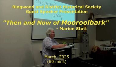 Ringwood and District Historical Society
Mixed media - Video, RDHS Meeting Presentation - "Then and Now of Mooroolbark" - Marion Stott OAM
Digitised video (3.68GB). Duration: 62 minutes. Recorded March, 2025 (Video is available for viewing at Ringwood & District Historical Society Archives by appointment)The Parish of Mooroolbark was surveyed in 1855, with a township originally called Brushy Creek standing where North Croydon is today. The name "Mooroolbark" was to be popularised with eventual European settlement in the late 19thy century. A rural hub developed around the train station, which opened in 1887 and offered rail access to Melbourne, with the Post Office opened shortly after in 1888. In this video presentation, Marion Stott, OAM, President and Founding Member of the Mooroolbark History Group, provides "Then and Now" details of all this and more. As well as activities in promoting local history, Marion is actively involved in local RSL, Traders group, and community events including Mooroolbark Red Earth Festival. For services to the community of Mooroolbark, Marion was awarded an OAM in 2020. -
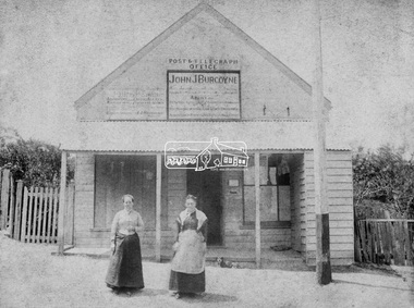 Eltham District Historical Society Inc
Photograph, Hunniford’s Eltham Post Office, Main Road near Bridge Street, Eltham, c.1888
Sepia photograph of Hunniford’s Eltham Post Office, Main Road near Bridge Street, Eltham, c.1888 (Postmistress Anne Hunniford possibly on left). The building originally had a shingle roof. Anne Hamilton born 1814 Co Tyrone, Ireland married Michael Head Burgoyne (1820-1843) in 1839, Co. Tyrone, Ireland. They had two children, Charlotte Caroline (1840) and John James Thomas Neville (Londonderry, Ireland 1844) Whilst pregnant with John, husband Michael died. Following John’s birth, she emigrated to Victoria, Australia where she married Thomas Hunniford in 1854. Daughter Anne Jane Hunniford was born in Eltham in 1855. Anne (Annie) Jane Hunniford and John James Thomas Neville Burgoyne were half siblings. In the mid 1860s Annie Hunniford succeeded her father, Thomas Hunniford as Post Mistress for Eltham. Photo dated based on advertising on façade of the building by Annie’s half-brother, John James Thomas Burgoyne promotes his services as the area manager for John M’Ewan and Co, Auctioneers as well as him being agent for the National Mutual Life Association of Australasia, National Insurance Company of Australasia, Federal Mutual Livestock Association of Australasia, and as a House, Land, Estate, Insurance and Financial agent. This was the time period that he placed advertising for same in the local paper. Australia Post: Gold brought life to the township - Diamond Valley News, Tuesday July 2, 1985, p17 On February 1, 1854, the first Eltham Post Office was established, commencing an association between the township and the Postmaster-General's Department that has continued for 131 years. At that time, the number of permanent residents would have been fairly small, probably less than 200. The discovery of gold in June 1851, at Anderson’s Creek, some five miles away, and later at Caledonia Diggings, Queenstown (now known as St Andrews), about 14 miles to the north-east, brought large numbers of prospectors passing through the township, hopefully culling the creeks and gullies for the precious metal. This additional "floating population" brought a greater demand for supplies and for communication with the outside world, and so it helped in the development of Eltham. Today, Eltham is a thriving township. It boasts an excellent shopping centre, municipal offices, court house. post office and many other amenities. Eltham continued to develop at a leisurely pace. During 1860, a total of just over 8000 postal articles were handled at the Eltham Post Office. By 1862, the mail route was "to and from Melbourne by way of Eltham and Kangaroo Ground, three times a week, by coach". There was also a branch mail that operated between Eltham and Greensborough, three times weekly. This was also conveyed by coach. Some time between 1864 and 1868 the management of the post office passed from Thomas Hunniford to his daughter, Miss Anne Hunniford, who managed the Eltham Post Office until her death in 1928. A big improvement in communication was provided for Eltham residents when a telegraph office was established at the post office in 1877. During 1923 a manual telephone exchange was provided at Eltham, the first two subscribers being J.J. O’Connor and Eltham Police Station. In 1949 the manual exchange was replaced by an automatic exchange and there were some 150 subscribers. Following the death of postmistress Miss Anne Hunniford in 1928, B.M. Burgoyne was placed temporarily in charge of the office. In 1929, J. N. Burgoyne was appointed postmaster, and he in turn was succeeded by H. C. Burgoyne in 1951. The post office was moved to a new site in 1954, but continued under the charge of Mr Burgoyne. In January 1958 there was a further change of site when the post office was raised to official status and transferred to new premises in Main Rd. William Donoghue was acting postmaster when the new office was opened. In March 1958 Mr W.E. Tovey was appointed postmaster, followed by Douglas McG. Gilmour in 1959. William Donoghue was fully appointed in 1966 and Barry Reichelt followed in 1973, prior to the present postmaster, Peter Jolly in November 1982. Peter is a young man with 18 years' experience. He commenced his training as a postal clerk at the training school in Melbourne in 1968 and was promoted to postal clerk at the Brunswick Post Office in 1969. He was finally transferred as postmaster to Fawkner Post Office in 1980. He has been at Eltham Post Office for the past 2½ years. He is married with one child and lives in Montmorency. The Eltham Post Office employs a staff of 21, of whom seven are indoor staff, 12 are postmen and two are drivers. The postmen in Eltham have an uphill battle delivering mail because of the hilly terrain. Nine of the postmen deliver mail on motorbikes, and the two delivery vans are both four wheel drives. Eltham Post Office services basically a residential area, with deliveries to 5600 homes. This is growing at the rate of 600 homes every 18 months, i.e. about 32 homes per month. At the present rate we will need a new postman every 18 months.Sepia photograph (two copies plus two black and white enlargements)Shop originally had a shingle roofpost office, eltham, main road, anne jane hunniford (1855-1928), federal mutual live stock insurance association of australasia, federal mutual livestock association of australasia, john j burgoyne, john m'ewan and co. auctioneers, national insurance company of australasia, national mutual life association of australasia -
 Federation University Historical Collection
Photograph - Photograph - Colour, Happy Valley School, 1985
This photo was taken in 1985. Alf Watson, a descendent of settlers of the district - the Smiths and the Yungs whose children attended this school, is standing to the right of the building. The history of Happy Valley State School 1863 The school opened as Lucky Woman's in 1863. The school was located in the Linton area, a small mining township. The first head teacher was Thomas Lea. 89 students had enrolled. 1883 The name of the school changed to Happy Valley. The brick school building was built in this period. 1920s Enrolment declined in the 1920s to around 10 students. 1932 Enrolment continued to decline and the school was closed. 1933 The school reopened briefly under head teacher Selina McFarlane. 1936 It closed again at some stage before reopening in 1936 under head teacher Maxwell Brown. The school was closed finally in 1936. 1940 The building was sold. 150 years: Happy Valley State School Learn about the history of Happy Valley State School, one of Victoria’s oldest public schools. Key information Address: Ballarat, 3350 Opened: 1 February 1860 Closed: 31 December 1940 School type: Primary School number: 376 Other names: Lucky Woman's Common School, Lucky Woman's State School Search for more school profiles The history of Happy Valley State School 1863 The school opened as Lucky Woman's in 1863. The school was located in the Linton area, a small mining township. The first head teacher was Thomas Lea. 89 students had enrolled. 1883 The name of the school changed to Happy Valley. The brick school building was built in this period. 1920s Enrolment declined in the 1920s to around 10 students. 1932 Enrolment continued to decline and the school was closed. 1933 The school reopened briefly under head teacher Selina McFarlane. 1936 It closed again at some stage before reopening in 1936 under head teacher Maxwell Brown. The school was closed finally in 1936. 1940 The building was sold. Can you help us find records for this school? The Public Record Office Victoria (PROV) only hold historical correspondence records for this closed school. If you have any, or if you know of any, please let us know by emailing [email protected] Updated 19 May 2022.1 Happy Valley State School photographed in June 1985. Alf Watson observing the building. .2 View from the back and side of the Happy Valley State School.1 Verso: Grandma Watson's school Happy Valley June 1985 (Grandma nearly 97 years) Alf in bacckground. Edith Emma Watson b Yung. Alf - son of Edith and John Richard Watson. .2 Verso: School where Grandma Watson eudcated. Happy Valley. June 1985happy valley state school, lucky womans, lucky woman's common school, lucky woman's state school -
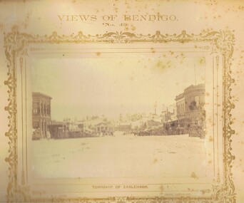 Bendigo Historical Society Inc.
Photograph - VIEWS OF BENDIGO: EAGLEHAWK HIGH STREET TOWARDS TOWN HALL, 1875
Sepia photograph. View looking north along High Street, Eaglehawk towards the Eaglehawk Town Hall and Virginia Hill behind. On either side of the street are double and single storied businesses. Wooden slatted tree guards, triangular configuration are close to the road gutter. Some horse-drawn vehicles are on the right side of the street. On Virginia Hill a mine and crushing battery building and chimney along with a few eucalypts can be seen. Inscriptions: Views of Bendigo No. 49', 'Township of Eaglehawk', 'NJ Caire photo Sandhurst', 'Casey & Wenborn's print', Forbes & Holmes Agents'. In grey lead on back of mount 'Mrs Brown, Barnard Street, Bendigo', Stamped 'Royal Historical Society of Victoria, Bendigo Branch'. In image 'Victoria Hotel, Sam Watson?', 'Saddler', 'Exchange Hotel'. History: in grey lead pencil, Mrs Brown, Barnard Street, Bendigo. Three col. Stamped 'Royal Historical Society of Victoria, Bendigo Branch', in ballpoint pen 1959, 71. (Two copies) Nicholas CaireNicholas J Caireplace, streetscape, high street, eaglehawk, the photographic mount -
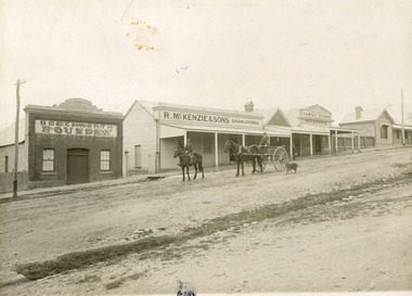 The Beechworth Burke Museum
Photograph, 1910
Taken in 1910, this photograph depicts a scene of Bridge road in Newtown, Beechworth. Walking on the road are two men on horseback, one of which is pulling a carriage with a small dog standing beside it. Behind them are a line of small buildings and shops. Small industries began to expand dramatically in Beechworth, particularly during the 1860s, leading to a strengthening of the towns economy. As early as 1853, areas surrounding the waterway known as Spring Creek were surveyed with the intent of mapping out plans for new roads and building allotments. Land was sold and new buildings were erected, creating an expansion of the Beechworth township and retail services. One building shown in this photograph is Straughair and Duncan's Beechworth Foundry. This business was established in 1858 through the partnership of Mark Straughair and John Duncan. It dealt mostly in the manufacturing of castings and mining machinery, receiving orders from all over the Ovens district. The Business eventually collapsed after the deaths of Straughair in 1882 and Duncan in 1896 but was reopened by W.H. Phillips in 1905. The two other buildings are both associated with the name McKenzie. Evidence suggests that the McKenzie family has a long association with the town of Beechworth. This photograph is historically significant as it provides insight into the nineteenth and twentieth century industrial expansions that happened in the area of Newtown, leading to the urbanisation of Beechworth. Black and white rectangular photograph printed on matte photographic paper mounted on card.Reverse: Newton / 1997.2648 / 33 Newton Beechworth / 84-219-1 / McKenzies / BMM3055 / newtown beechworth, bridge road, 1910, j. duncan, r. mckenzie, m. straughair, industrial growth, ford street, beechworth foundry, straughair and duncan, mckenzie and sons grainstore, mckenzie family store -
 The Beechworth Burke Museum
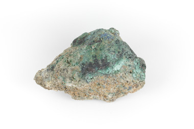
Geological specimen - Malachite, Unknown
Malachite is typically found as crystalline aggregates or crusts, often banded in appearance, like agates. It is also often found as botryoidal clusters of radiating crystals, and as mammillary aggregates as well. Single crystals and clusters of distinguishable crystals are uncommon, but when found they are typically acicular to prismatic. It is also frequently found as a pseudomorph after Azurite crystals, which are generally more tabular in shape. This particular specimen was recovered from the Burra Burra Copper Mine in Burra, South Australia. Otherwise known as the 'Monster Mine', the Burra Burra Copper Mine was first established in 1848 upon the discovery of copper deposits in 1845. Within a few short years, people from around the world migrated to Burra to lay their claim in the copper economy. By April 1848 the mine was employing over 567 people and supporting a population of 1,500 in the local township. Up until 1860, the mine was the largest metals mine in Australia, producing approximately 50,000 tonnes of copper between 1845 to its closure in 1877. The Burra Burra Mine was also famous for a number of other specimens, including; crystalline azurite, cuprite, and botryoidal and malachite. Malachite is considered a rare gemstone in that the original deposits for the stones have been depleted leaving behind very few sources. In addition, the use of Malachite as gemstones and sculptural materials remains just as popular today as they were throughout history. It is quite common to cut the stone into beads for jewellery. The fact that Malachite has such a rich colour and one that does not fade with time or when exposed to light makes it particularly rare. This specimen is part of a larger collection of geological and mineral specimens collected from around Australia (and some parts of the world) and donated to the Burke Museum between 1868-1880. A large percentage of these specimens were collected in Victoria as part of the Geological Survey of Victoria that begun in 1852 (in response to the Gold Rush) to study and map the geology of Victoria. Collecting geological specimens was an important part of mapping and understanding the scientific makeup of the earth. Many of these specimens were sent to research and collecting organisations across Australia, including the Burke Museum, to educate and encourage further study. A solid hand-sized copper carbonate hydroxide mineral with shades of blue and light green throughout. burke museum, beechworth, indigo shire, beechworth museum, geological, geological specimen, mineralogy, burra, burra burra mine, south australia, malachite, malachite specimen -
 Eltham District Historical Society Inc
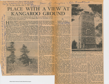
Folder, Basil Hall, 1999
Original newspaper article from "The Age" May 11, 1963. Place with a view at Kangaroo Ground by Basil Hall about the construction of the War memorial. The Hall family resided at "Fairview" Panton Hill in the 1920s. Hall was a Eltham Shire Councilor in the 1920s and was associated with the Eltham Shire war Memorial Tower Bulding Committee from 1924 to 1926. Photocopies from "The Road to Gundagi" by Graham McInnes (Hamish Hamilton, 1965), Chapter 9 pages 132 - 153 an autobiography in which the author reminiscences about visiting the Hall family at "Fairview" in Panton Hill as a child. References also to Watson's Creek where MacPherson Robertson ("The Chocolate King") had a summer home, the Shannons, Shanhun and McLaughlin familes. Includes description of the day that Hurstbridge was declared a township (May 26th, 1924), a ralway journey, picnics and rabbiting. McInnes' reminiscences about the periods of his childhood spent visiitng the Hall family in Panton Hill in the 1920s are a rare first hand glimpse into the recreational, social and municipal life in the 1920s within the this rural area within the Shire of Eltham. "Road to Gundagi" was the first of three widely acclaimed autobiographies.Original newspaper article Photocopies, 12 pages.HG Booklet 36basil hall, click here to add keywords, cr. basil hall, eltham war memorial, graham mcinnes, harry gilham collection, hurstbridge, kangaroo ground tower building committee, macpherson robertson, mclaughlin family, panton hill, picnicing, rabbiting, reminiscences, shanhun family, shannon family, shire of eltham war memorial, war memorial tower, watson's creek -
 Eltham District Historical Society Inc
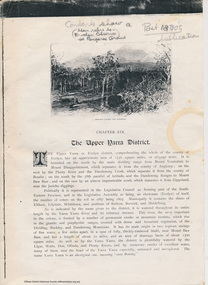
Folder, The Upper Yarra District, 1888
Photocopies from "Victoria and its Metropolis: Past and Present". Chapter 19, "The Upper Yarra District" pages [402] - 415. Includes descriptions of some townships and short biographies of local residents. Victoria and Its Metropolis' is a large two volume history of Victoria, written in 1888 by Alexander Sutherland. It contains a huge amount of information on the people of the colony and its early history. The first volume covers information from the discovery of Australia, through to the exploration of Victoria and the first settlers to the pioneers. It then continues on to discuss immigration, the era of gold, the development of government, agriculture, music and art, literature and the metropolis of Melbourne. A large portion of the second volume examines the colony by district, which covers many districts throughout the state as well as the metropolitan area. Hundreds of biographical entries are scattered throughout and a comprehensive biographical index is included at the end. The British Library has scanned Volume 2 and it can be downloaded at http://access.bl.uk/item/pdf/lsidyv30336ba8 Images from the book are on Flickr Commons via the British Library https://www.flickr.com/photos/britishlibrary/ Keywords in this record highlight those residents connected to Eltham and district7 A3 Pages HG Booklet 45harry gilham collection, james andrew, w. b. andrew, alfred armstrong, simon armstrong, thomas armstrong, john bell, mary ann bell, thomas m bell, ewen hugh cameron, mary cameron, james charlton, j.m conolly, andrew harkness, william hubbard, james johnston, james mcpherson, robert parry, george stebbing, joseph stevenson, j.b. thomas, james thomson, mary weller, isidore t. wilmot, john b. wilson, walter wippell -
 Eltham District Historical Society Inc
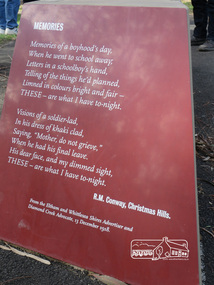
Photograph, Shire of Nillumbik World War One Memorials tour, 10 August 2016, 10 August 2016
Memories Memories of a boyhood's day. When he went to scahool away Letters in a schoolboy's hand. telling of the things he's planned, Linned in colours bright and fair - THESE - are what I have to-night. Visions of a soldier-led, In his dress of khaki clad, Saying, "Mohter, do not grieve." When he has his final leave. His dear face, and my dimmed signt THESE - are what I have to-night. R.M. Conway, Christmas Hills From the Eltham and Whittlesea Shire Advertiser and Diamond Creek Advocate, 13 December 1918. As part of a program to acknowledge the Anzac Centenary Nillumbik Shire Council partnered with Yarra Plenty Regional Library to provide a bus tour with commentary of local sites of significance. These included Eltham township, the Shire of Eltham War Memorial at Kangaroo Ground, Christmas Hills, Hurstbridge memorial recreation park and finished at Eltham Library to view the Writing the War exhibtion at Eltham Library Community Gallery. In May 2015 Nillumbik Shire Council received Anzac centenary Local Grants Program funding for the restoration and enhancement of Christmas Hills cenotaph as a project to commemorate the First World War. Born Digitalworld war 1, war memorials, shire of nillumbik, christmas hills, interpretative signage, poem, "r.m. conway" -
Federation University Historical Collection
Booklet, GIAE Official Opening, 1976, 11/1976
The Gippsland Institute of Advanced Education was established by an Order-in-Council in September 1968. On its establishment, the Institute assumed responsibility for the diploma coursed previously offered at Yallourn Technical College. In 1972 the Institute transferred part of its operations to the first of its permanent buildings on a large campus in rural surrounding near the township of Churchill, ten kilometres south of Morwell, and 160 kilometres east of Melbourne. The campus site plan report prepared in 1970 by the Institute's campus planners, Yuncken Freeman Architects Pty Ltd, provided the conceptual base for the development of a new campus at Churchill. All facilities were planned to converge on a central space; all having the ability to expand outwards. Central to the campus plan was the concept of an internal pedestrian street connecting all academic divisions to the central facilities. The first building was completed in 1972. The Administration Building, Visual Art & Maintenance Workshops, Multi-Purpose Building, and Student residences were designed by Yuncken Freeman Architects. The central Facilities Building (cafeteria and Union) were designed by Chancellor and Patrick, the Education Building and Applied Science Building is designed by Eggleston, McDonald and Secomb.Grey and yellow soft covered booklet prepared for the official opening of Gippsland Institute of Advanced Education.gippsland institute of advanced education, gippsland campus, churchill, m.w. hopper, c.h. ford, lindsay thompson, j.l. carrick, r.w. muncey -
![Ceramic, Ino Kiyoshi, [Vase] by Ino Kiyoshi, c1982](/media/collectors/530576742162ef0fa09a2288/items/5566bbdf2162f113608fc669/item-media/60f41b51b06f0c13a9354719/item-fit-380x285.jpg) Federation University Art Collection
Federation University Art CollectionCeramic, Ino Kiyoshi, [Vase] by Ino Kiyoshi, c1982
Ino KIYOSHI (b 1946, Kyoto Japan, d. 2008) Worked in Australia from 1973–76 and 1978–2008 Ino Kiyoshi was to a family that has been involved in the production of pottery for some 160 years. Working in the family studio while studying at the Kyoto School of Arts and Crafts, he completed his diploma of Ceramic Art in 1969. He then attended the KyotoTechnical School for a post-graduate course in glazing. then lectured in ceramics at the KyotoTechnical School. Following in the footsteps of the famous Japanese potter, Shoji Hamada who had visited Australia in 1965, Kiyoshi Ino visited Sydney in 1973, where he worked with Japanese potter Shigeo Shiga). Kiyoshi took up an appointment as Visiting Lecturer in Ceramics at the Gippsland Institute of Technical Education, Churchill, Victoria, from 1974 to 1976 and returned there as Assistant to the Senior Lecturer in Ceramics in 1979. He ceased teaching at the Gippsland Institute in 1988. Ino was involved in the establishment of a space for artists in the old butter factory at the nearby township of Yinnar and in 1982 the Yinnar Art Resource Collective, commonly known as Yinnar ARC, was established. Ino has exhibited extensively throughout Australia.Australian Studio Ceramics Gift of the artist, 1982Impressed seal for Kiyoshi Ino on baseceramics, gippsland campus, jan feder memorial ceramics collection, ino kiyoshi, japanese ceramics -
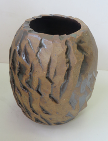 Federation University Art Collection
Ceramic, [Untitled] by Ino Kiyoshi, c1982
Ino KIYOSHI (b 1946, Kyoto Japan, d. 2008) Worked in Australia from 1973–76 and 1978–2008 Ino Kiyoshi was to a family that has been involved in the production of pottery for some 160 years. Working in the family studio while studying at the Kyoto School of Arts and Crafts, he completed his diploma of Ceramic Art in 1969. He then attended the KyotoTechnical School for a post-graduate course in glazing. then lectured in ceramics at the KyotoTechnical School. Following in the footsteps of the famous Japanese potter, Shoji Hamada who had visited Australia in 1965, Kiyoshi Ino visited Sydney in 1973, where he worked with Japanese potter Shigeo Shiga). Kiyoshi took up an appointment as Visiting Lecturer in Ceramics at the Gippsland Institute of Technical Education, Churchill, Victoria, from 1974 to 1976 and returned there as Assistant to the Senior Lecturer in Ceramics in 1979. He ceased teaching at the Gippsland Institute in 1988. Ino was involved in the establishment of a space for artists in the old butter factory at the nearby township of Yinnar and in 1982 the Yinnar Art Resource Collective, commonly known as Yinnar ARC, was established. Ino has exhibited extensively throughout Australia. Gift of the artist, 1982impressed seal for Kiyoshi Ino on baseceramics, shikuhu ino, jan feder memorial ceramics collection, gippsland campus, yinnar, yinnar art resource collective