Showing 11157 items
matching re-survey
-
 Bendigo Military Museum
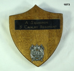
Souvenir - SHIELD 3 CAV, C.1960’s
Item in the collection re Geoff Murray No 3411521, served Vietnam with 3 Cavalry Regt 27.11.1967 to 22.10.1968, Survey Corp 15.10.1969 to 15.10 1970. refer Cat No 638P.Wooden shield shape with metal plaque reading "A Squadron 3 Cavalry Regiment" and that unit's badge in silver coloured metal.military history-regimental shield, 3 cav -
 Bendigo Military Museum
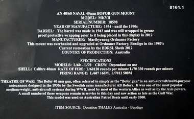
Weapon - NAVAL GUN MOUNT, 40MM, Maribyrnong Ordnance Factory Australia, C.1934 - 1990’s
This item is on display in the gardens of the Bendigo District RSL Sub Branch Havilah Road. Refer photo .1) for details re manufacture, history and use..1) Plaque metal black on a stand with white text re details of the item. .2) Naval AN 40/60 Bofor Gun Mount Model MKV11 painted blueish colour, barrel black, sits on its traversing base.brsl, smirsl, bdrslinc, bofor, 40 mm, naval -
 Bendigo Military Museum
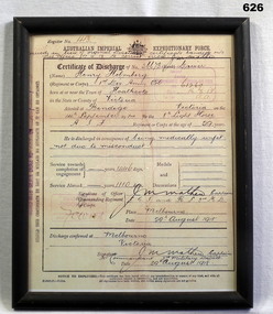
Certificate - DISCHARGE CERTIFICATE, FRAMED, Original 29/8/1918
Henry Holmberg No's 334, 26673 8th L.H Regt AIF. Refer 54P for full service details re Henry and brother Carl. Also 609PCertificate of Discharge re Henry Holmberg, copy of original for display. Details name, rank, Regt number, enlistment date, reason for discharge, service number, home and abroad time and discharge date. Frame is black wood."Register No 413"frame accessories, documents - certificates, discharge -
 Stawell Historical Society Inc
Map, Gold Mines of Australia, Gold Mines of Australia underground workings. Newington Rd Darlington Rd Area 1950, 1950
Plans Showing Surveys & Drilling Stawell InvestmentGold Mines of Australia Stawell Investment 2003 mining, gold, map -
 Port Fairy Historical Society Museum and Archives
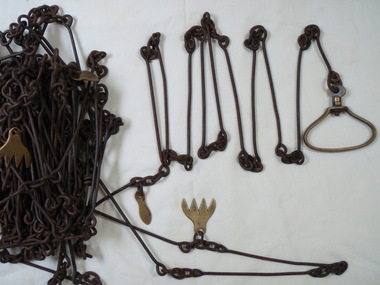
Functional object - survey chain
metal surveying chain with brass markers and handlesJames Beddington "Warranted correct"local history, surveying, terrestrial, survey chain beddington -
 Mission to Seafarers Victoria
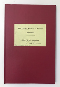
Book (item) - Visitor logbook, The Victoria Missions to Seamen Melbourne- Sailor's Rest Williamstown Visitors' Book, 1933 - 1944
This book or register records the date, name and address and ship name and remarks of visiting seafarers from a wide range of origins. The logbook provides an insight into which ships and the origins of their crews were visiting Williamstown and Melbourne in 1933. This together with the 1945 register from Williamstown (see VC MtSV record) provides the earliest such register records surviving in the Mission heritage collection and Archive.Cover: The Victoria Missions to Seamen Melbourne / Sailors' Rest Williamstown/ Visitors' book/ 1933 ( February1933 - March-1944) / Spine:/Sailors' Rest, Williamstown - Visitors' book 1933. Inner page: details of Chaplains and caretakers and contact nos re the Mission.seafarers, seafarer registers, seafarer's rest, seafarer's rest williamstown, visitors log book, box 24, williamstown, sailors, seamen, mrs hodgkiss, j.g. sheel, crew, nationality, padre frank leslie oliver -
 Bendigo Military Museum
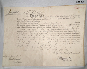
Certificate - CERTIFICATE, OFFICER WW1, 1) 24.3.1917
Items re David James Wallace HAMILTON No 329 . KIA 7.6.1917. Refer Cat No No 2351.5P for his service details..1) Certificate, cardboard, yellowed, folded re David James HAMILTON being for his appointment to 2nd Lieutenant. Printed in black with black pen writing ornate. Stamped seal on one side. .2) Envelope for .1) Paper yellowed with black print..1) Bottom L: "D J Hamilton Second Lieutenant Land Forces Australian Machine Gun Corps" .2) Printed top centre: "ON HIS MAJESTY'S SERVICE" Printed bottom L: "DEPT OF DEFENCE MELBOURNE" Handwritten centre: "Mrs L Hamilton Royal Hotel Williamstown Vic"certificate, officer -
Whitehorse Historical Society Inc.
Letter - Correspondence, Correspondence from Robert P. Holbery, 13/03/1972 12:00:00 AM
Letter from Robert Holbery to Mrs Leach. Re his life and family in Nunawading from 1900. He and his brother first to enlist for World War I. His father was an original Cobb & Co driver.Letter from Robert Holbery to Mrs Leach re his life and family in Nunawading from 1900. He and his brother first to enlist for World War I. His father was an original Cobb & Co driver.Letter from Robert Holbery to Mrs Leach. Re his life and family in Nunawading from 1900. He and his brother first to enlist for World War I. His father was an original Cobb & Co driver.holbery, robert p., pioneers -
 Bendigo Military Museum
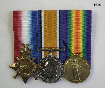
Award - MEDAL SET, Post WW1
Alfred Gray No 3766 enlisted in 12th reinforcements 6th Batt AIF on 9.7.15 age 44 years 4 months, embarked for Eygpt on 23.11.15, embarked for France 29.3.16. He Died of Disease (DOD) on 16.8.16, Dilation of the Heart and Anaesthenia. Refer 1658 re his brother.Medal set, court mounted, set of (3) re Alfred Gray. 1. 1914-15 Star. 2. War Medal 1914-1919. 3. Victory Medal."3766 Pte A.Gray 6 Bn AIF"numismatics- medals - military, metalcraft -
 Bendigo Military Museum
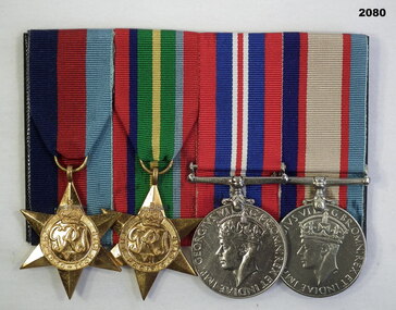
Award - MEDAL SET, Post WW2
Alfred Charles Jury VX66822 enlisted on 13.12.41 aged 21 years. At discharge from the 2nd AIF he was a Gunner in 2/4th L.A.A. Regt. Refer 2083P, 2079.3 also 2082 re his father.Medal set, court mounted, set of (4) re A.C.Jury. 1. 1939-45 Star. 2. Pacific Star. 3. War Medal 1939-45. 4. Australian Service Medal."VX66822 A.C.Jury"medals, military, history -
Port Melbourne Historical & Preservation Society
Archive - Alan Mathews and family
The Mathews family have been in continuous ownership of 395 Howe Parade (was 8 Howe Parade until 1964 when addresses re-assigned), Port Melbourne from 1938 to the present (Sept 2019)Six folders of assorted documents relating to the life of Alan Mathews and his family. Details of insurances and purchases Letter from Eagle Star Insurance Co Ltd re purchase at James McEwan & Codomestic life, alan mathews -
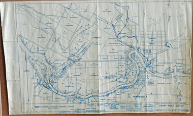 Orbost & District Historical Society
survey, 1941
this item is a useful reference tool.A survey map produced by the State Rivers and Water Supply Commission. It is on white paper with blue ink. It is a hand-drawn survey of the Snowy River in 1939-40.survey map snowy-river -
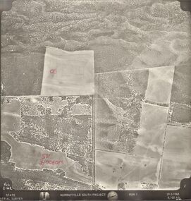 Bendigo Historical Society Inc.
Photograph - MURRAYVILLE SOUTH PROJECT
State Aerial Survey. A set of aerial surveys related to the Murrayville South Project. Run 1. Vic. 2162. 29-2-1968. 53 photos.photograph, aerial, murrayville south project, photos, murrayville south project, state aerial survey, surveys, murrayville, photographs, photography, aerial photography -
University of Melbourne, Burnley Campus Archives
Plan, Plan of the Melbourne Botanic Gardens, 1948
Partially coloured plan on a grid. Prepared from Field Notes of Survey by F.C. Ridoutt drawn and reproduced at the Dept. of Lands & Survey, Melbourne, March 1948.f.c. ridoutt, gardens, melbourne -
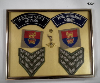 Bendigo Military Museum
Memorabilia - INSIGNIA, FRAMED, C. 1956 onwards
Item in the collection re MAX Jolliffe, refer Cat No 4322.3 for service/ other details.Framed gold colour metal with MDF backing, inset are two shoulder patches, "15 National Service Battalion" and "Royal Australian Signals". Centre is a Signals badge and a small crown, either side of that is cloth arm badges re "Australian Army HQ", under are two sets of Sgt's stripes.framed, memorabilia, insignia, rank, badges -
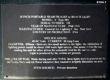 Bendigo Military Museum
Equipment - SEARCH LIGHT, MOBILE, General Arc Lighting C. Inc New York, C. 1940 - 45
This item is in the gardens of the Bendigo District RSL Sub Branch Inc Havilah Road. Refer photo .1) For details re manufacture, history and use..1) Plaque black metal on stand with white text re details of the item. .2) Mobile search light portable Model: 4 - Type MX with 49.0 cm lens, mounted on a base with two tyres and towed. painted a greyish colour.brsl, smirsl, bdrslinc, search light, mobile -
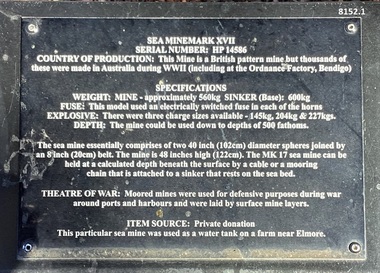 Bendigo Military Museum
Weapon - SEA MINE, MARK XV11, 1939 - 45
This mine is situated in the gardens of the Bendigo District RSL Sub Branch Inc Havilah Road Bendigo. Refer photo .1) re details of manufacture and its history/use..1) Plaque on black metal stand with white text with details re the mine. 2) Mine slightly oval shape, black with a white band, the top has a bolted on section as a lid, there are multiple "horns" attached around the mine.Refer .1) plaque.brsl, smirsl, bdrslinc, sea mine -
Whitehorse Historical Society Inc.
Document, EastLink, 2005-2008
Miscellaneous brochures, newsletters and notices distributed to local residents about aspects of the construction of the EastLink tollway.Miscellaneous brochures, newsletters and notices distributed to local residents about aspects of the construction of the EastLink tollway. Includes partial runs of EastLink News March 2005-June 2008, EastLink Construction Update December 2005-February 2008, and Community Connect Forum papers and Property Condition Survey Report for 7 May Court Mitcham.Miscellaneous brochures, newsletters and notices distributed to local residents about aspects of the construction of the EastLink tollway. may court, mitcham, no. 7, freeways, roads and streets, seita, thiess john holland, vicroads, victoria. department of infrastructure, mitcham frankston project. community connect forums -
Port Melbourne Historical & Preservation Society
Letter - Freemason Grand Master Elections, 6 Mar 1941
The Mathews family have been in continuous ownership of 395 Howe Parade (was 8 Howe Parade until 1964 when addresses re-assigned), Port Melbourne from 1938 to the present (Sept 2019)Six folders of assorted documents relating to the life of Alan Mathews and his family. Employment documents. Folder 5 has wartime and other general interest papers. Letter re Freemasons Grand master's electionssocieties clubs unions and other organisations, alan mathews -
Port Melbourne Historical & Preservation Society
Letter - Accommodation Bookings, RACV, 10 Sep 1962
The Mathews family have been in continuous ownership of 395 Howe Parade (was 8 Howe Parade until 1964 when addresses re-assigned), Port Melbourne from 1938 to the present (Sept 2019)Six folders of assorted documents relating to the life of Alan Mathews and his family. Employment documents. Folder 4 has Motor car purchases, Registration, Licences & RACV RACV letter re accommodation bookingsrecreation, alan mathews, commonwealth aircraft corporation, cac -
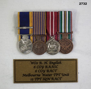 Bendigo Military Museum
Award - MEDAL SET, Post WW2
Re. W.O. 2 R.M. ENGLISH\ 6 Coy R.A.A.S.C. 6 Coy R.A.C.T. Melb Water TPT Unit 15 TPT SQD R.A..C.T.Medal set, miniature, court mounted, wt of (4) Re R. ENGLISH. 1. Reserve Force Medal with one clasp 2. National Medal 3. Defence Medal 4.Anniversary of National Service Medal 1951 - 1972medals, military, history, passchendaele barracks trust -
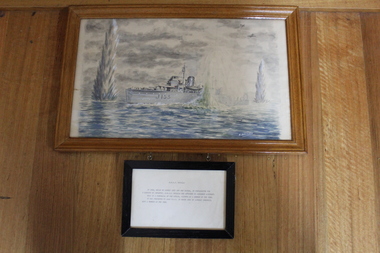 Lara RSL Sub Branch
Painting of H.M.A.S. Whyalla off New guinea, 1944
WW2, H.M.A.S. WhyallaWW2, H.M.A.S. Whyalla painting1. Painting of H.M.A.S. Whyalla on survey duty off New Guinea in 1944 , framed in glass and wooden frame. 2. Separate small framed statement of the painting with details of the action being under-taken by H.M.A.S. Whyalla. hanging from the paniting frame middle/centre.H.M.A.S. Whyalla In 1944, while on survey duty off New Guinea, in preparation for a landing by infantry, H.M.A.S. Whyalla was attacked by by Japanese aircraft. This is a portrayal of the attack, painted by a member of the crew it was presented to Lara R.S.L. in March 1981 by Lindsay Dunsmuir, also a member of the crew. Artist name B. Andeasenww2, lindsay d. dunsmuir,, 1944 -
Whitehorse Historical Society Inc.
Legal record - Land Title, Central Road, 1975
Certificate of Title Vol. 4891 Fol. 97808 to William Elliott Wilson, 2 August 1924, with transfers to 5 May 1975.Certificate of Title Vol. 4891 Fol. 97808 to William Elliott Wilson, 2 August 1924, with transfers to 5 May 1975. With floor plan of house, and letter from National Library of Australia to Mrs L Tetlow re. John Flynn's ownership of the house.Certificate of Title Vol. 4891 Fol. 97808 to William Elliott Wilson, 2 August 1924, with transfers to 5 May 1975. central road blackburn, no. 93, flynn, john, rev. -
 Bendigo Military Museum
Pamphlet - An Introduction to Topographic Mapping, C 1991
This pamphlet was published by the Army Survey Regiment as an overview of the Royal Australian Survey Corps (RASvy), its role and unit structure circa 1991, prior to RASvy’s disbandment in 1996. The pamphlet comprehensively detailed the eight steps of topographic map production: Establish Survey Control, Aerial Photography, Aerotriangulation, Stereoplotting, Field Verification, Cartography, Printing and Storage/Map Distribution. Leading technologies used by RA Svy in 1991 included GPS control surveys, 5 colour printing on the Speedmaster offset press and bulk map packaging using the Map Handling Station (with guillotine). Digital map production was operating on the AUTOMAP 2 system, before the “Newheart” system upgrade two years later. Printed on the pamphlet cover was a portion of the plane tabled “four inches to a mile” map of Newcastle. This was compiled and surveyed in 1910 by LCPL A. Barrett, a member of the RAE Detachment, as part of the first major topographic mapping effort of Australia.This is a Royal Australian Survey Corp pamphlet with a historical map printed in colour on cardboard on both sides of the cover. There are 16 pages printed in colour on gloss paper, with photos, diagrams and descriptions. The pamphlet is bounded by two staples on its spine. Each of the 17 images were scanned at 300 dpi in JPEG (.jpg) format and stored on the attached 16 Gb USB memory stick. The images have been converted into MPEG-4 (.mp4) video format, 4Mb in size and runs for 2:16 minutes and is also stored on the memory stick.royal australian survey corps, rasvy, fortuna, army survey regiment, army svy regt, asr -
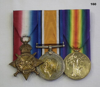 Bendigo Military Museum
Award - MEDAL SET, Australian government, Post WW1
Robert Slyvester TELFORD, No. 2048 enlisted on 27.8.14 in 3rd Aust Field Artillery Bde. Embarked for Eygpt 20.10.14. Joins MEF for Gallipoli 4.4.15. Embarks for France 23.3.16, WIA 21.3.18 GSW left forearm, discharged from the AIF 18.2.19 medically unfit. Refer 157.2 medals re his brother.Medal set, court mounted, set of (3) re R Telford. 1. 1914-15 Star. 2. War Medal 1914-19. 3. Victory Medal. "2048 DVR R.TELFORD 3/FA BDE AIF" medals-military, numismatics, metalcraft -
Whitehorse Historical Society Inc.
Letter - Correspondence, State School Heatherdale, 1879, 1879
Copy of letter to G.W. Brown Esq [Secretary, Education Department] dated 19 Dec 1879 from William WittCopy of letter to G.W. Brown Esq [Secretary, Education Department] dated 19 Dec 1879 from William Witt re rental of land and building to the Education Department for a state school at Heatherdale; with document entitled 'Nunawading North' detailing activities on the site to 1885.Copy of letter to G.W. Brown Esq [Secretary, Education Department] dated 19 Dec 1879 from William Witt heatherdale primary school, primary schools, witt, william, brown, g.w., victoria. education department -
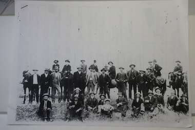 Kiewa Valley Historical Society
Papers photocopied - photo, list of names, Kiewa Valley Pioneers and Early Activities on the Bogong High Plains
All Early History of the Kiewa Valley. 1. Photo clear but no date. Men named and are residents selecting a site for a bridge at Keegans Crossing 2. Department of Crown Lands letter - 1841 Tawonga pastoral run - Mr James Roberts and Mullindollingong pastoral run 1846 - Mr Patrick Reynolds 3. An account of the Bogong High Plains by W. F. Waters from the late 1890s to 1930s. Published article in the Schuss magazine. August 1958 History of Keegan's Crossing, Kiewa Valley and surrounding residents with names and photos. Early pastoral runs in the Kiewa Valley and Early activities on the Bogong High Plalns..1.The photo includes a listing of residents selecting a site for a bridge at Keegans Crossing. 2. A letter from the Department of Victorian Lands and Survey re early settlers 3. History written in Schuss magaine, Aug. 1958. "In 1896 ... erection of snow poles from Rocky Valley to Tawonga Hut. keegan's crossing, w.f. waters, tawonga and mullindollongong pastoral runs -
Port Melbourne Historical & Preservation Society
Document - List, City of Footscray councillors re function, Port Melbourne Town Hall, W H Swaby, Town Clerk, City of Footscray, 1968
List of Footscray councillors stapled to compliments slip. From group of related papers and documents kept by Town Clerk Andy AANENSEN relating to a function held at Town Hall 19.4.1969.Annotated in pencil, re responses to invitationlocal government - city of port melbourne, andreas (andy) t aanensen, town clerks, celebrations fetes and exhibitions -
 Robin Boyd Foundation
Document - Script, Robin Boyd, The Flying Dogtor. Episode 32 Spooks, 1963
The bush children were exploring around an old deserted house called Mangrove Mansion when they received a number of nasty shocks: strange signs; spiderwebs; and spooks. Then they were chased by a great white creepy-looking floating monster spook and driven into a corner from which there seemed to be no escape. How they wished they were not so far from their friend, The Flying Dogtor.The Flying Dogtor" series was broadcast on Australian Television Network (later becoming the Seven Network) between February and April 1964 (see item D254 for schedule).Typewritten, carbon copy, foolscap, 3 pages. Middle page has one cm cut from the bottom.Handwritten pencil additions re telestrip.the flying dogtor, robin boyd, crawford productions, manuscript -
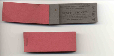 Ballarat Tramway Museum
Ephemera - Ticket, State Electricity Commission of Victoria (SECV), SEC Provincial Tramways "Staff Ticket"
Demonstrates aspects of the SEC ticketing, governance and monitoring systems. The Pass or ticket could be issued to a SEC staff member to enable travel on the tramways while on business. Style remained very similar to the end of the tramways.Six blocks of SEC Provincial Tramways "Staff Ticket" and four individual tickets. Individual tickets printed on heavy dark grey (Grey 200 gsm card) with black printing. Ticket blocks consist of 50 printed tickets, with stubs, stapled with red cardboard covers. Ticket good for single trip only, of use by employees when travelling on Commission's business. Form No. TYE-2-19. Not known when printed, possibly 1960's maybe earlier. 2101.1 - Aa 002580 - 2599. Has "Tramway offices" written on back of block in black ink. 2101.2 - Aa 002800 - 2849. 2101.3 - Aa 002952 - 2999 2101.4 - Aa 002611 - 2649 2101.5 - Aa 002393 - 2399. Has "Traffic ? ? " written on back of block in black ink. 2101.6 - Aa 002650 - 2699 2101.7 - Aa 002491 2101.8 - Aa002492 2101.9 - Aa002493 2101.10 - Aa002494See notes re 2101.1 and 2101.5trams, tramways, tickets, staff tickets, employees pass