Showing 11564 items matching " maps"
-
 Bendigo Military Museum
Map - MAP of IRAQ
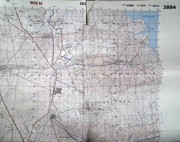
... maps ...Four topographical maps taped together of Tall Uwaynat and Tall Musa region of Iraq. Item belonging to Mathew Redwood. Refer Cat No 3891 for his service details.White paper, folded, four maps sticky taped togetherOrange fluoro marking out route taken by Australian forces in escort duties.maps, iraq -
 Greensborough Historical Society
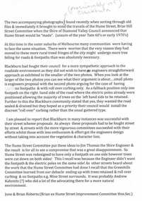
Folder, Hume Street Improvement Committee, 1958_
The Hume Street Improvement Committee was one of several 'progress associations' in the Greensborough area at the time the area was being urbanised. A typed page explains the concerns of residents when the street was being paved. Includes photographs and maps of area.These documents are concerned with the urbanisation of Greensborough in the mid 20th century while residents tried to maintain the rural feel of the area.Foolscap manilla folder containing various lists, maps and photographs.On cover "Hume Street Improvement Committee/ spare circulars/maps"greensborough, road making, brian roberts, hume street improvement committee, briar hill -
 Federation University Historical Collection
Map - Geological, Tallangatta, New South Wales: 1:250,000 Geological Series, SJ 55-3, 1966, 1966
Compiled by the Geological Survey of N.S.W., Division of Regional Geology. Topographical base compiled from Snowy Mountains Hydro Electrical Authority, Department of Lands, County maps and Snowy Lease Map. Other sheet adjoin this map. There are 13 formation sections grouped into 9 - Quaternary, Tertiary, Middle Devonian, Lower to Middle Devonian, Lower Devonian, Upper Silurian, Silurian, Upper Ordovician and Ordovician.Large coloured map showing geological features, faults, bores, rivers and mineral deposits.Scale of map, longitude and latitude, river names. "Tallangatta 1:250,00" written in black pen.tallangatta, new south wales, geological survey, topographical base, snowy mountains hydro electrical authority, department of lands, snowy lease map, department of mines, quaternary, tertiary, middle devonian, lower to middle devonian, lower devonian, uper siluran, silurian, upper ordovician, ordovician -
 Lara RSL Sub Branch
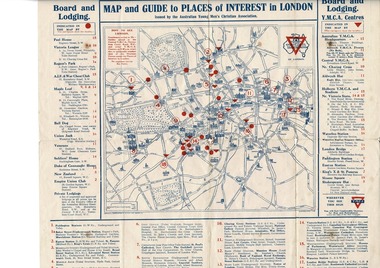
Map, Map of London
Map of London including Places of interest and Accommodation for Australian Navy, and Australian Imperial ForceMap given to Australian Navy and Imperial forces in London during WW1Map of London - YMCA - Place of Interest and Accommodation for Soldiers and Sailors in London 1917Map of London Rising Sun Badge Places of interest Accommodation for sailors and soldiers in Londonmap london ymca ww1 -
 Wangaratta RSL Sub Branch
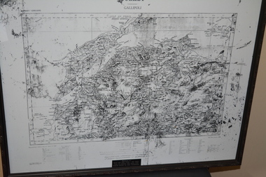
Map - Framed Map, Gallipoli, C1915
Reproduction copy of original map of Gallipoli taken from Turkish Army Officer by the Grandfather of David and John Evans Black frame containing black and white Map of GallipoliTURKEY GALLIPOLI Copy of original map taken from Turkish Officer by the Grandfather of David and John Evans gallipoli, map, turkey, ww1 -
 Eltham District Historical Society Inc
Book, Melway Publishing, Melway Greater Melbourne street directory : including Geelong, Phillip Island, Healesville, Bellarine & Mornington Peninsulas, 2002
... maps ...Edition 29. Coloured detailed maps accessed by a street or location index. Cover: 20 additional pages of new maps, extended coverage of Bellarine Peninsula, further coverage of Werribee South, Public Transport Information, latest official suburb boundaries, CBD "hook turn" intersections map, over 1200 new streets, 1 atlas (24, 886 p.) : col. maps ; ISSN 03113957streets, roads, melbourne, maps, melway -
 Clunes Museum
Map
... maps ...MAP DATED JULY 21ST,1873MAP OF CLUNES WATER SUPPLY, TOWNSHIP OF CLUNES, SHOWING SYSTEM OF DISTRIBUTION.TOWNSHIP OF CLUNESlocal history, document, maps, clunes water -
 Nhill Aviation Heritage Centre
Map - Aeronautical Maps x 9, May 1943
Typical of the maps used during navigation training here at Nhill during WW2Aeronautical maps of Victoria, Printed on light card green text and markingsThird Edition May 1943, Sheet K8, Australian Aeronautical Map, Equatorial scale 1:1000,000map, aeronaughtical map, navigation -
Whitehorse Historical Society Inc.
Map, Nunawading Map, 1960's?
... Maps ...Nunawading map Sections 114 -118, 120 - 126, 129 - 132 Scale 1 inch = 4 chainsNunawading map Sections 114 -118, 120 - 126, 129 - 132 Scale 1 inch = 4 chainsNunawading map Sections 114 -118, 120 - 126, 129 - 132 Scale 1 inch = 4 chainsmaps, nunawading -
 Bendigo Military Museum
Map - TRENCH, BATTLE & ORDNANCE MAPS FRANCE WW1, All 1918
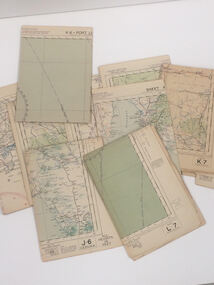
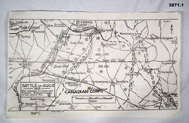
... maps ...(.2) Areas on map relate to : The Hindenburg line on the left, from the top, Bony to Bellicourt to Bellenglise, Estrees to Brancourt. (.3) The River Somme runs through from top corner left bottom corner right. Main areas are Belloy, Picquigny, Bertangles, Montieres. The map finishes just short of “Amiens” Items in the collection relating to F.A.W Hutson No 3539 AIF. refer Cat No 922 for his service history.(.1) Map on paper showing the “Battle of August 1918”, Map C, The Advance to “Lions & Proyart”. (.2) Trench map, gauze lined, sheet 62B N.W, trenches corrected to 8.2.1918, German trenches in blue, scale 1:20,000, France. (.3) Ordnance survey map, May 1918, France, Edition 1, sheet 62 E N.E, scale 1:20,000, a canal and river runs through the centre(.2) On rear hand written “62 B N.W” (.3) On rear hand written “D.M.F 62 E N.E”august 1918, maps, somme -
 Victorian Aboriginal Corporation for Languages
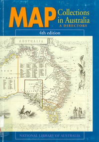
Book, Map collections in Australia : a directory, 1991
... maps ...mapsmaps, map collections -
 Tatura Irrigation & Wartime Camps Museum
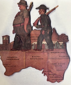
cut out plywood figures, Guarding Australia
Karl Streker cut out the map of Australia using a razor blade with Private Tony Connor and Private Alf Gillespie on garrison duty.Cut out plywood subjects - two of our Garrison guards with guns, standing on cut out map of Australia. Borders and capital cities are marked. Guard tower and barracks are in the background. State borders and capital cities are marked on map.internee hand craft, karl streker, private tony connor, private alf gillespie -
Whitehorse Historical Society Inc.
Map, Nunawading Shire, 1892
... Maps ...Photocopy of an enlargement of map of Shire of Nunawading showing landowners in 1892.Photocopy of an enlargement of map of Shire of Nunawading showing landowners in 1892. Covers Middleborough Road to Ringwood boundary. One map (Blackburn) from north of Whitehorse Road to Highbury Road, 2nd map (Mitcham) Bulleen to south of Canterbury Road; 3rd map Whitehorse Road to Highbury Road.Photocopy of an enlargement of map of Shire of Nunawading showing landowners in 1892. maps, shire of nunawading, blackburn, blackburn south, nunawading, forest hill, vermont, mitcham, vermont south -
 Melbourne Tram Museum
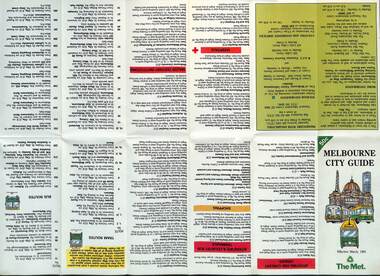
Map, The Met, "Melbourne City Guide", March 1991
... maps ...Map issued by The Met, March 1991 based on a Melway map of the Central city area providing details of tram, bus and trains, attractions, major institutions, tourism information, and dining out areas or streets. Demonstrates a map produced by The Met to assist Melbourne visitors.Map - 14 fold printed on gloss paper.trams, tramways, the met, maps, melbourne, cbd -
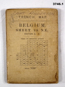 Bendigo Military Museum
Map - TRENCH MAPS, BELGIUM WW1, 1) 1917; .2) & .3) 1916
... Maps ....1) Areas covered on this map include Zonnebeke, Broodseinde, Passchendaele, Westhoek, Glencorse Wood & Black Watch Corner. .2) Areas covered on this map include Bailleul, Neuve Eglise, Messines, Wyschaete, Warneton & Hollebeke. .3) Areas covered on this map include Poperinghe, Ypres, Dickebusch & Zillebeke. The maps are part of a collection of 27 collected by William Arthur ALEXANDER, No 502 AIF. He enlisted in the 8th reinforcements MG Coy 3 on 5.9.1916 aged 21 years. Embarked for England on 23.11.1916, transferred then to the 5th Div MG Coy. Embarked for France on 26.4.1917 then transferred to the 13th MG Coy on 16.6.1917. WIA 28.9.1917 gassed, he is later hospitalized with Colitis. Rejoined unit in the field 18.6.1918. Discharged from the AIF 18.9.1919..1) Trench Map, Belgium, sheet 28 NE Edition 6A, folding, scale 1.20,000, trenches corrected to 3.7.1917, German trenches in red. On rear glossary of terms French to English. .2) Trench Map, Belgium & France, sheet 28 SW Edition 3D, folding, scale 1.20,000, trenches corrected to 22.6.1916. German trenches in red, British in blue. On rear glossary of terms French to English. .3) Trench Map, Belgium, sheet 28 NW Edition 3D, folding, scale 1.20,000, trenches corrected to 25.6.1916. German trenches in red, British in blue. On rear glossary of terms French to English..1) Handwritten on front: “CAPT ANDERSON”maps, trench -
 Kiewa Valley Historical Society
Maps - Educational x 10 and Kiewa Scheme x1
... Maps ...Maps were used to teach children geography, the explorers, the minerals, the world etc. The school bought and stored the maps so that they were available for use. This predated electronic devices. The KHE Works map was hand drawn showing lots of detail.These maps were used by the Bogong Primary School. The Kiewa Hydro Electric Works was built by the SECV and produced hydro power. This map may have been used by pupils as well as workers on the Works. Large coloured maps on canvas, with a wooden beam along the top and bottom. Each one has a cord attached to the top so that the map may be hung up on a wall. Some are made by Chas. H. Scally & Co., Baronia Ave., Wollstonecraft, N.S.W. The Kiewa Hydro Electric Works map is pinkish and shows Rocky Valley Dam, Lake Guy and Mt Beauty pondage in dark blue.maps, educational maps, geography, primary school, kiewa hydro electric works -
Whitehorse Historical Society Inc.
Map, Nunawading Map. Large Scale, 1960's?
... Maps ...Sheet 4 Nunawading map sections 117B -120, 125 -130 and 138B and 148. Scale 1 inch = 4 chainsSheet 4 Nunawading map sections 117B -120, 125 -130 and 138B and 148. Scale 1 inch = 4 chainsSheet 4 Nunawading map sections 117B -120, 125 -130 and 138B and 148. Scale 1 inch = 4 chainsmaps, nunawading -
 Eltham District Historical Society Inc
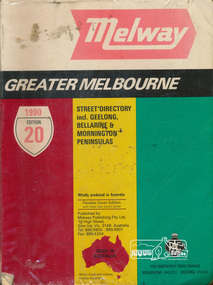
Book, Melway Publishing, Melway Greater Melbourne Street Directory, edition 20, 1990, 1990
... maps ...Coloured detailed maps accessed by a street or location index.500 p. : col. maps ; Flexible cover edition with fitted clear plastic jacket.ISSN 03113957streets, roads, maps, melway -
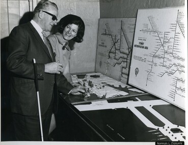 Vision Australia
Photograph - Image, Jack Chamberlain reading a tactile map of Sydney with Val Hickey, 1970?
... Maps ...Jack Chamberlain (P.R.O.) feeling a relief map of Sydney's CBD, with Val Hickey (Publicity Officer).2 x B/W photographs of man looking at transit map4/70414 and 6/70414royal blind society of nsw, jack chamberlain, val hickey, maps -
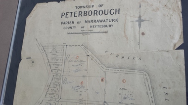 Peterborough History Group
Map - Map of the township of Peterborough, Township of Peterborough
... maps ...Same map as 4012 but printed names are easier to read. Hand drawn arrows show the road now built connecting Macs St to the Warrnambool RdShows early layout of the town and names of landownersgovernment map of the township of Peterborough with handwritten notes on it. Includes the names of the landowners 1931some hand drawn arrows.peterborough, old maps, maps -
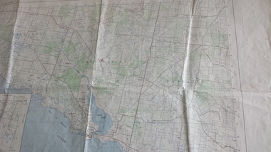 Peterborough History Group
Map - Government map, Government Printer, Port campbell, 1957
... maps ...Aerial survey map showing roads, vegetation and other landscape features.Significant because it shows the detail of the region in 1957Original 1957 State Aerial Survey Map of Port Campbell region, including Peterboroughpeterborough, aerial survey map, maps, port campell -
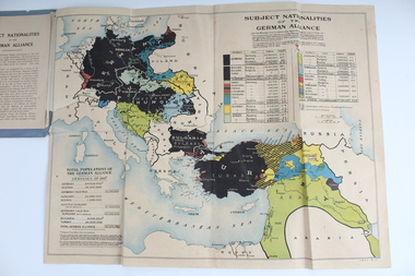 Lara RSL Sub Branch
Booklet With Map, Cassell and Compnay Limited, Subject Nationalities of the German Alliance, 1917
Map Produced for Allied ForcesMap of German Alliance as to which nationalities were aligned with GermanyGrey Booklet containing Coloured map of the German AllianceGrey Booklet Subject Nationalities of the German Alliance (With a coloured map from German Sources) Cassell and Company Limited London New York Toronto Melbourne 1917 Price 2d -
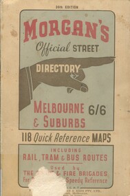 Surrey Hills Historical Society Collection
Book, Morgan's Official Street Directory, c1940s
... maps ...incl.index. This Street Directory of Melbourne and suburbs, c1940s, includes a list of suburbs, their mileage from the city and how to reach them; an index to localities as well as the index to streets appearing on the maps. It also shows bus routes, railways and tramways routes on the maps.incl.index. This Street Directory of Melbourne and suburbs, c1940s, includes a list of suburbs, their mileage from the city and how to reach them; an index to localities as well as the index to streets appearing on the maps. It also shows bus routes, railways and tramways routes on the maps.melbourne metropolitian area, suburbs, cities and towns, maps -
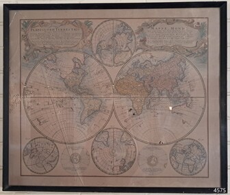 Flagstaff Hill Maritime Museum and Village
Map - World Map, Mappe Monde [Medieval Map of the World], 1910
This map from the mid-18th century doesn't include the finer details of land and sea masses that we know today. The map was produced by German cartographer and publisher, Johann Baptist Homann (1663-1724) and published in 1746, after his death. Earlier versions were published, such as 1707 and 1716. The date can be calculated from the Roman numerals on the top left text area. This print of a map is significant for its connection with early world explorers. A comparison of maps over the centuries shows the progression of navigational technology, the countries who claimed the land they explored. The naming of even some Australian locations shows who had already made their mark on Australia in the early 18th century. The print shows the fine details included by the cartographer and the beauty included that makes it attractive and interesting even today. The map is also significant for its connection with German cartographer, Johann Baptist Homann, whose Homann publishing company was renewed in Germany for producing high quality maps and atlases. Map behind glass in dark brown wooden frame on beige paper. The Coloured hand drawn line drawings show different hemispheres of the known world in the mid-18th century. Beautifully drawn figures and decorative embellishments enhance the map. The text on the top right has an explanation of the Figures I, II, III, and IV. This print of the 1746 map was produced in England by Leisure Arts Ltd. "PLANIGLOBIL TERRESTRIS" "MDCCXXXXVI" [1746] "MAPPE_MONDE" [Medieval Map of the World] "LEISURE ARTS LTD" "Printed in England"flagstaff hill, warrnambool, flagstaff hill maritime museum, flagstaff hill maritime village, flagstaff hill maritime museum and village, shipwreck coast, world map, french map, 18th century map, leisure arts ltd, cartography, early exploration, cartographer, johann homann (1663-1724), exploration, naviagtion, 1746 planiglobil terrestris -
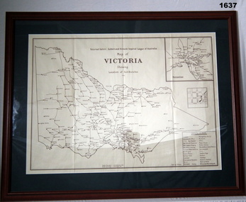 Bendigo Military Museum
Map - RSL'S VICTORIA, FRAMED, Bethany Gallery, 1949
This map originally came via Mitiamo East Loddon RSL who when they closed their Sub branch the map and their records were handed to the Bendigo RSL for safe keeping. It was framed and was hanging in the Office of the SMI until the renovations to the building in 2016.Dark green mount with brown wooden frame. Brown printing on cream paper. Perspex covering map.Top centre of map: “Returned Sailors, Soldiers & Airmen's Imperial League of Australia Map of Victoria showing Sub Branches 1949” Stamped on rear: Bethany Gallery. Traditionally a touch of Excellence Terry ? Jarvis, 116 Bridge Street, Bendigo Vic 3550 Ph (03) 5442 4771brsl, smirsl, map rsl's -
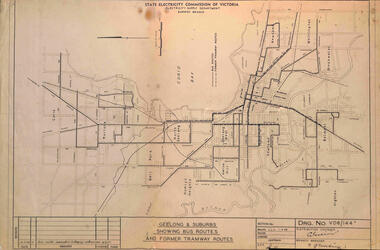 Ballarat Tramway Museum
Map, State Electricity Commission of Victoria, "Geelong & Suburbs Showing Bus Routes and former Tramway Routes", 19-3-1968
... maps ...Map or drawing titled "Geelong & Suburbs Showing Bus Routes and former Tramway Routes", dated 19-3-1968, SEC Drawing No. VD6/144A.Demonstrates an SEC document showing a comparison between Geelong tram routes and the 1968 bus routes.Map or drawing No. VD6/144A, folded into 3.tramways, secv, geelong, buses, maps -
 Melbourne Tram Museum
Map, Victorian Railways (VR), "Melbourne and Suburbs", 1956
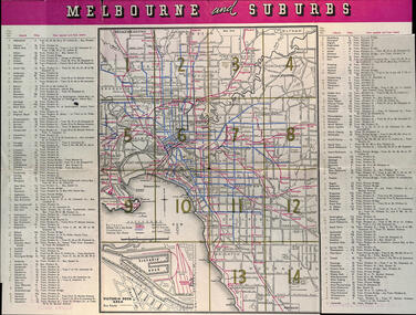
... maps ...Map printed by the Victorian Railways in 1955 gives places of interest, some facts about Melbourne, and amusements, with the map showing rail, tram, and railway bus routes, suburbs, golf links, sporting grounds, and municipalities. The Bourke St tram route to East Preston is shown but not the Nicholson St East Brunswick line which opened during mid 1956. Provides a detailed list of suburbs, miles from the GPO, and how reached from where. Notes it was published in Jan. 1956 by the VR Public Relations and Betterment Board.Demonstrates a Victorian Railways printed map of MelbourneMap - 8 fold printed in colourmaps, melbourne, tramways, bus routes, railways -
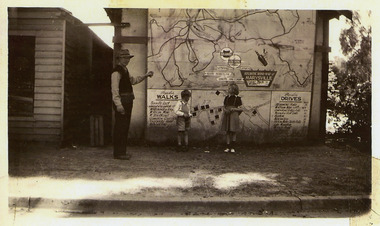 Marysville & District Historical Society
Photograph (Item) - Black and white photograph, 1949
... maps ...A copy of a black and white photograph of an Atlantic Road Map of Marysville adhered to an unknown building in Marysville.A copy of a black and white photograph of an Atlantic Road Map of Marysville adhered to an unknown building in Marysville.marysville, victoria, maps, atlantic road map -
 Greensborough Historical Society
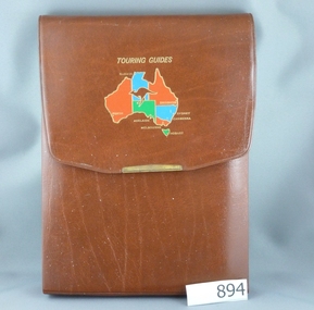
Road Maps, The Herald Road Guide, 1955-1956
... maps ...Contains maps of Melbourne and surrounding areas as well as routes from Melbourne to other state capitals.Contains maps and descriptions of the Melbourne area in the era before the large scale urbanisation after 1960. Also includes country and day tour maps before highways were common.Book of road maps, 271 pages, in brown plastic carry case.maps, melbourne, victoria, day tours, touring maps -
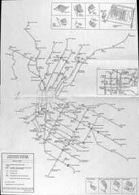 Melbourne Tram Museum
Map, P. Sohns, "Strassenbahn Melbourne Gleisplan", 10-9-1992
... maps ...Map of Melbourne's tramway system prepared for a German audience - as at 28-5-1992. Shows the track layout, crossovers, depots, route numbers, railway/tramway level crossings, terminus details, road names and a CBD insert. Prepared by P Sohns of Germany - dated 10-9-1992.Yields information Melbourne tramways and routes in 1992.Map - A2 sheet folded to A4.tramways, maps, melbourne, germany