Showing 2330 items matching "bogong"
-
 Kiewa Valley Historical Society
Photographs x 2 - Clover Dam, Circa 1940's
As part of the push to cut electricity costs and diversify supply, the Victorian Government (circa 1930) implemented the conversion strategy from mainly brown coal supply to hydro - electricity. The Kiewa Hydroelectric Scheme became the largest scheme of its kind in the State Of Victoria and the second largest scheme in Australia. Clover Dam and Power Station were built by the State Electricity Commission of Victoria as part of the Kiewa Hydro Electric Scheme from the late 1930's to the early 1940's. This dam was constructed to supply water to feed four turbines (62 mega watts) at the West Kiewa Power Station. This was at the forefront of sustainable "Green" energy. Costs associated with power supplies is still a major incentive of governments, however environmentally friendly alternatives such as wind and nuclear have also made inroads. The Kiewa valley and its surrounding alpine catchment were looked at(Victorian State Government), from the beginning of the twentieth century as a source of alternate power for an ever-increasing demand for electricity by growing population and heavy industrial areas within Melbourne City and State regions. Construction of dams, such as Clover Dam provided the large quantity holding areas of water required to turn the turbines at the various power stations to provide the electricity needed. The impact of these controls by moderating water run-off from the alpine regions is beneficial in reducing flooding from thawing of snow on the alps. This by-product allows agriculture and grazing to be less vulnerable to seasonal flooding thereby resulting in a more stable annual production level. Photographs also document early engineering and building techniques used in the construction of dams and power stations during the 1940’s and 1950’s. Note the lack of safety equipment and suitable work attire worn by construction workers on the sites 1. Black and white photograph of Clover Dam under construction. Has a .5cm white border around photo 2. Black and white photograph of Clover Dam under construction showing workmen at work. Has a .5cm white border around photo Written in pencil on back of both photographs - Clover Damclover dam, secv -
 Kiewa Valley Historical Society
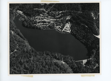
Photograph of Lake Guy Dam, Spillway, Lake Guy Dam, c1945
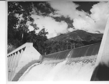
In December 1939 the excavation of the diversion tunnel at the site of Junction (Lake Guy) Dam was commenced and finished in February, 1940.This allowed the stream to be diverted to facilitate the dam wall construction. This is a 'slab and buttress' dam. It is framed with timber and concrete then poured into the structure. A contract was let to Lewis Construction Co. for the construction of the dam, and the first batch of concrete was placed in September, 1940. Industrial trouble caused some delays but there was also slow progress on the part of the contractor and the work was taken over by the S.E.C., terminating the contract. The dam was completed in March, 1944. The lake is named after Mr. L.T. Guy who was the Resident Engineer, in charge of construction work and associated activities on the Kiewa area, from 1939 until November 1946. An historical pictorial record taken for the State Electricity Commission of Junction Dam (Lake Guy) on spill. Mt. Arthur is in the background and there is still evidence of the destruction of trees from the 1939 bushfires. Black and white photograph of Lake Guy Dam . The dam is spilling and Mt. Arthur is in the background. Hand written on back of photograph in blue ink " Lake Guy Dam".dam, lake, water, mr. l.t.guy -
 Kiewa Valley Historical Society
Photograph of Lake Guy Dam, Walkway, Inside Lake Guy Dam, c 1945
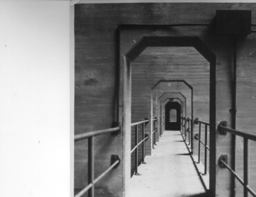
Lake Guy Dam is a 'slab and buttress' type wall. A timber frame is built and then filled with concrete. The first batch of concrete was placed in September, 1940. By June, 1941 the buttresses were finished to a height safe from floods and in October of that year a flood of 2,800 cusecs occurred but with only slight damage to the installations. Industrial trouble caused some delays but there was also slow progress on the part of the contractor and the work was taken over by the S.E.C., terminating the contract. The dam was completed in March, 1944. A walkway was made through the dam wall. Lake Guy was named after Mr. L.T. Guy who was the Resident engineer, in charge of construction work and associated activities on the Kiewa Area from 1939 to November 1946.Shows the walkway placed as part of the Lake Guy (Junction) Dam wall. A very good pictorial reference for the future.Black and white photograph of the walkway through Lake Guy (Junction) Dam wall.Handwritten in blue ink on back of photograph "Inside Lake Guy Dam". slab, buttress, dam, mr. l.t. guy -
 Kiewa Valley Historical Society
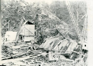
Photograph of Clover Dam foundations, Clover Dam Foundations, 1949
Stripping of the foundations commenced in 1948 and the first concrete in the dam was poured in May, 1949. With the suspension for the winter months of work on the High Plains, it was possible to increase the number of men, and work then proceeded at a steady pace for the remainder of the year. Some interruption was caused by a flood in September, which over topped the rockfill coffer dam. By the end of 1950 17,000 yards of material had been excavated from the foundations and 4,000 cubic yard of concrete placed. Work at Clover Dam was completed in 1953, but two bays were left open for flood emergency. The pondage was filled on the 16th August, 1954. A pictorial record of the placing of concrete foundations of Clover Dam and also shows the methods of construction used at this site in 1949.Black and white photograph taken during the construction of Clover Dam. Shows early stages of the concrete foundations, cranes and the railway line which was constructed to bring materials to the site. Handwritten in blue ink of back of photograph "Clover Dam Foundations"dam, foundations, concrete, construction -
 Kiewa Valley Historical Society
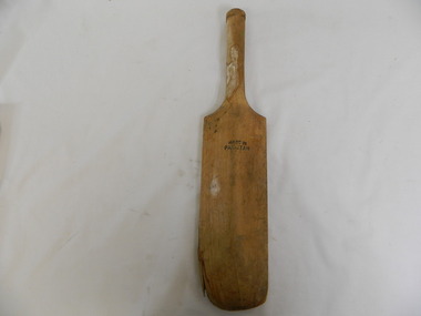
Rounders Bat
This rounders bat was used by the students at Bogong Primary School.Historical: Bogong Primary School was opened for the Kiewa Hydro Electric Scheme workers. Provenance: Bogong Primary School sport.Wooden bat. The face of the bat is flat and the other side becomes thicker (is tapered) towards the centre in a longitudinal direction. The handle is cylindrical.'Champion' 3 quarters of the way up the bat towards the handle on the flat side of the bat. On the reverse side same position, Made in / Pakistan. On the flat side: Bogong has been written in thick black but faded paint.rounders. sport. bogong primary school. kiewa hydro electric scheme. game -
 Falls Creek Historical Society
Newspaper - Australia's Playground of the Future
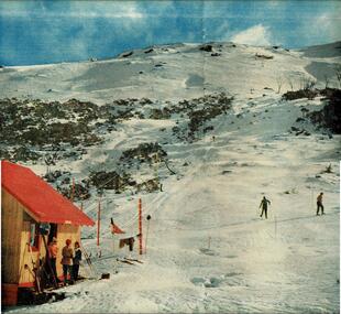
Australian Magazine (A.M.) published a special three page article about Falls Creek and the Bogong High Plains on 24th August 1954. The article was titled "Australia's playground of the future". Written by Muir Maclaren, it referred to the Bogong High Plains as a comparatively new and unexploited winter playground which could be one of the best snow resorts in the world. There were 13 huts which were at Falls Creek which were there due to "hard work, the grace of God, and the permission of the Victorian State Electricity Commission". A brief history of the Albury Ski Club Lodge was included. In 1954 the Lodge was run byLes Meikle and had the Club had a membership of 200 people. Lodges with accommodation established at this time, with the ability to house a total of 280 people, included Albury, Skyline, Bogong, Myrtleford, Hymans, Dawn, Galleon, Kiewa Valley, Snowden, Nelse, Moroma, Trowalla, St, Trinian's, Bowna and Nissen. Fred Griffith, as a member of the Albury Ski Club and owner of Bowna Lodge escorted the reporter and explained the potential of Falls Creek and the surrounding area to become a year-round playground, a paradise for tourists and a great income-earner for the State.This article and accompanying images are significant because they capture early information about the Bogong High Plains, Falls Creek and its pioneers.A centre spread from a monthly publication featuring text and colour imagesBelow photo The ski tow at the foot of Bogong High Plains, an area of 280 square miles of unequalled ski-ing country.fred griffith, falls creek pioneers -
 Kiewa Valley Historical Society
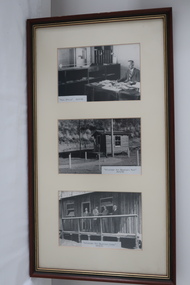
Set of 3 photos in one frame - at Bogong - Kiewa Hydro Electric Scheme
Official photos - Kiewa Hydro Electric Scheme constructed by State Electricity Commission of VictoriaOfficial photos of KHES in the Kiewa Valley1. Post Office - Bogong - 26th February 1940 2. Volunteer Air Observers Post - Bogong - 24th May 1943 3. Volunteer Air Observers Corps - Bogong - 24th May 1943khes, secv -
 Kiewa Valley Historical Society
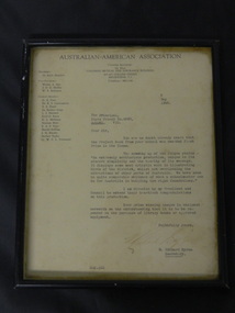
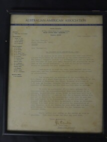
Framed Letter - Bogong State School 1946, 6 May 1946
Bogong State School was awarded First Prize in its Class for 'the Project Book'. The school received a cheque for the purchase of library books or approved equipment.Bogong is a town established by the State Electricity Commission of Victoria during the construction of the Kiewa Hydro Electric Scheme. The project "displays some most artistic work in illustrating birds of the district" confirming that the principal at the time had a very good reputation especially with his knowledge of the surrounding bush and wild life.Dark wooden frame, glass cover, cardboard back not attached to the frame. 2 rings screwed at the top on the sides of the frame with string attached to each. Paper yellowed letter titled "Australian American Association" dated 6 May 1946 addressed to the Principal Bogong State School.bogong state school; australian american association; -
 Falls Creek Historical Society
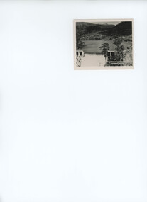
Postcard - Mt. Beauty, Victoria
These photographs were taken in and around Mount Beauty and the Kiewa Valley by Samuel Keith Pearce and printed for him as a foldout postcard by NuColor Vue. The postcards state they were printed for S. K. Pearce Pty. Ltd of Tawonga and Mount Beauty. Samuel Keith Pearce was born on 24 June 1917 in Armadale, Victoria. By the late 1940s he owned the Mt Beauty Supermarket, Newsagency, Drapery and Hardware store at Mount Beauty and also a store at Tawonga in partnership with his brother Gordon Cathew Pearce. For some time, they operated as Pearce Brothers. In the early 1960s Keith also opened a mini mart In Falls Creek. As well as being a keen photographer and an astute businessman, Keith Pearce was a well-known identity in the Kiewa Valley, making many contributions to the development of the area over a long period. This included serving as a member of the Bright Shire Council for many years. He worked hard to promote the interests of the Upper Kiewa Valley. As a sign of recognition and appreciation for his contribution to the community, the park opposite the grocery store in Mount Beauty was named the SK Pearce Gardens in his honour. Samuel Keith Pearce died on 7 July 1994 in Mount Beauty, Victoria Mt. Beauty at the head of the Kiewa Valley was established by the State Electricity Commission during the development of the Kiewa Hydroelectric Scheme. It forms the gateway to the Bogong High Plains, and is a popular centre for holiday makers in the north-east providing accommodation and access to excellent fishing grounds and, in winter, to the popular ski slopes of nearby Falls Creek.This collection of postcards and images is significant because they were commissioned by a highly successful businessman in Falls Creek, Victoria.A colour image of Mt. Beauty Township and Mt. Bogong from Power Line Lookout.mt. beauty, s. k. pearce -
 Falls Creek Historical Society
Newspaper - Australia's Playground of the Future
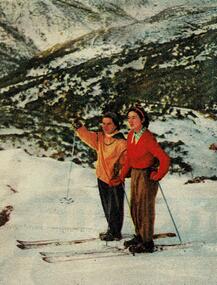
Australian Magazine (A.M.) published a special three page article about Falls Creek and the Bogong High Plains on 24th August 1954. The article was titled "Australia's playground of the future". Written by Muir Maclaren, it referred to the Bogong High Plains as a comparatively new and unexploited winter playground which could be one of the best snow resorts in the world. There were 13 huts which were at Falls Creek which were there due to "hard work, the grace of God, and the permission of the Victorian State Electricity Commission". A brief history of the Albury Ski Club Lodge was included. In 1954 the Lodge was run byLes Meikle and had the Club had a membership of 200 people. Lodges with accommodation established at this time, with the ability to house a total of 280 people, included Albury, Skyline, Bogong, Myrtleford, Hymans, Dawn, Galleon, Kiewa Valley, Snowden, Nelse, Moroma, Trowalla, St, Trinian's, Bowna and Nissen. Fred Griffith, as a member of the Albury Ski Club and owner of Bowna Lodge escorted the reporter and explained the potential of Falls Creek and the surrounding area to become a year-round playground, a paradise for tourists and a great income-earner for the State.This article and accompanying images are significant because they capture early information about the Bogong High Plains, Falls Creek and its pioneers.A centre spread from a monthly publication featuring text and colour imagesBeside photo Peg Plunkett and Angela Bowlar on the summit of the Bogong High Plains, where the snow is perfect for six to eight months a year.bogong high plains, snow conditions falls creek -
 Kiewa Valley Historical Society
Papers - Mt Bogong (Two articles), Australian & New Zealand Ski Year Book: 1. Pages 91-94 and 2. Pages 45 -55
Mt Bogong is visited all year round. In 1936 Cleve Cole died after having been lost in a blizzard close to its summit. This resulted in the erection of snow poles and the Cleve Cole Hut.Mt Bogong, the highest mountain in Victoria, used by skiers in winter and bushwalkers in summer. The weather is variable.1. Article includes 'New Summit Hut' & includes effect of cattle on skiing conditions - 4 pages stapled top left corner 2. The Mt Bogong Disaster, 1936 Cleve Cole, Rescue. 10 pages stapled top left cornercleve cole, mt bogong, summit hut, snow, skiing disaster. -
 Kiewa Valley Historical Society
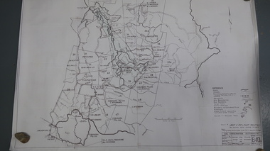
Maps - Kiewa Valley Parish Maps x3 and Kiewa Area Planimetric Map x1
Planimetric maps are 2 dimensional representations of the Earth's surface, showing the location and spatial arrangement of features such as roads, buildings, and bodies of water. The parish maps show the occupiers with leases or licences of the land. These are updated by the Department of Lands regularly. The names of early settlers of the Kiewa Valley occupying land by lease or licence are shown. Many of these familie's descendants still live in the Kiewa Valley.1. Kiewa Area Planimetric Map (photo) 2. Wermatong, County of Bogong Parish Map 3. Mulllindolingong, County of Bogong Parish Map 4. Mullagong, County of Bogong Parish Map All black and white kiewa valley. parish maps. land owners -
 Kiewa Valley Historical Society
Framed Letter - Bogong State School 1948, 29th November 1948
Bogong State School was awarded First Prize in its Section for the 'Project Book Competition'. The school received a cheque for 10 pounds and an invite to the presentation (or to be posted).Bogong is a town established by the State Electricity Commission of Victoria during the construction of the Kiewa Hydro Electric Scheme. The Head Teacher encouraged pupils to enter competitions for their benefit and that of the school including positive publicity.Dark wooden frame, glass cover, brown paper backing. Two rings screwed at the top on the sides of the frame with string attached to each. Paper yellowed letter titled "Re Project Book Competition, 1948" dated 29th Nov. 1948 addressed to The Head Teacher Bogong State School.bogong state school; project book competition -
 Kiewa Valley Historical Society
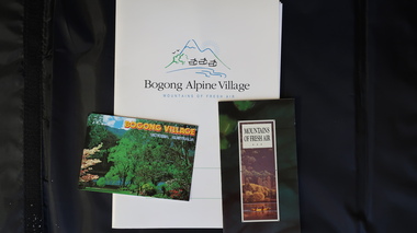
Papers - Bogong Village & the 'Commissioner's' Lodge & Progress Association Members, c 1997/1998
Bogong Village was built by the SECV in 1940 for the workers of the Kiewa Hydro Electric Scheme. In 1971, 30 houses were furnished for use as holiday homes for SEC personnel throughout the State. From 1989 to 1993 the houses were restored & renovated.During the 1990s the buildings in the village had been leased to private owners. Many of them rented their houses for tourists. The Commissioner's lodge was on the other side of the Mt Beauty - Falls Creek road, above Bogong Village. Wally Baldwin ran it in the 1960's.It was destroyed by the 2003 bushfires.These papers present a history of 'the Commissioner's lodge' and Bogong Village in the 1990's. The Progress Association was an active community group in 1963/64.Papers advertising Bogong Village & the Lodge for accommodation with rates 1997/1998. Describes the alternatives, maps and cafe hours, Also, 'Jan's Recollections' and on the back of these pages a hand written list of members of the the Progress Association 1963-64 as 'per Mr A. McCullough's spiel'. In original folder and includes a pamphlet & postcard.bogong village, secv lodge, lake guy, state electricity commission of victoria., kiewa hydro electric scheme, tourism, accommodation -
 Kiewa Valley Historical Society
Photos - Kiewa Hydro Electric Scheme - Bogong, Official S.E.C.V. photos
Kiewa Hydro Electric Scheme Bogong Area -
 Kiewa Valley Historical Society
Map - Bogong High Plains - Grazing Runs, Grazing Run Boundaries 1960 - Soil Conservation Authority
Cattle grazing on the Bogong High Plains during summer commenced in the 1840s and continued for many years. The Soil Conservation Authority recorded each family's area boundaries which were updated in June 1972 and continued to be adjusted until cattle were banned in 2005. The tradition of cattle grazing continues to be controversial.Holders of grazing rights for grazing on the Bogong High Plains were allocated specific areas recorded by the Soil Conservation Authority in 1972. Cattle have been banned in the Alpine National Park due to their impact on the environment.White paper with brown print. Bogong High Plains from Feathertop in the west to Mt Nelse in the east showing physical boundaries including the Kiewa Hydro Electric Scheme, roads, rivers and mountains. Names of families with grazing runs and the boundaries are shown.cattlemen, grazing runs, bogong high plains, kiewa valley families -
 Kiewa Valley Historical Society
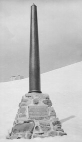
Photo: Memorial on the Staircase Spur Track, Mt Bogong
Mt Bogong is the highest mountain in Victoria. The Staircase Spur track to its top starts at Mountain Creek Road going through forest and continuing above the snow line to grass land. The weather can change very quickly with cloud and snow making conditions dangerous. Large sepia photo of the Memorial in snow on the Staircase Spur Track on Mt Bogong. The Memorial has a plaque attached: Sacred to the Memory / of Georgine Gadsden / Edward Neave Welch / John McRae / who perished here during a blizzard / about August 2nd 1943staircase spur memorial, mt bogong -
 Kiewa Valley Historical Society
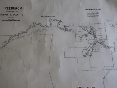
Map - Freeburgh - Counties of Bogong and Delatite
Drawn and reproduced at the Dept. of Lands and Survey, Melbourne, Victoria November 1948Black and white map of Freeburgh, County of Bogong and Delatitefreeburgh, map county of bogong and delatite -
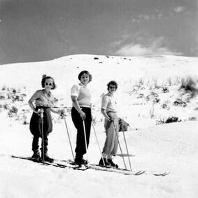 Falls Creek Historical Society
Photograph - Skiers
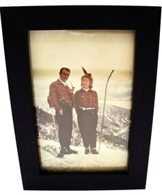
This photo is part of the Fred Griffith Photographic Collection documenting his time with the Australian Alpine Club and the formation of the Albury Ski Club. Frederick Charles “Fred” Griffith was born in Albury, NSW on 2 March 1910. Educated in Albury and Geelong Grammar. Beginning in 1927 he spent many years working first as a jackeroo and on a range of prominent pastoral and merino stud properties in NSW and Queensland. In 1935 he repurchased his former family property “Toonallook", Bowna, NSW and developed it to be the largest Romney Marsh stud in the world, exporting rams to Argentina. He introduced many innovative practices on his property including rabbit control measures and aerial crop dusting. He was an active member of the Albury Show Society and in 1949 established the Albury Sheep Show. Fred was also the Albury representative on the Graziers’ Association Council for over 30 years. He became a life member of both the Albury and Commercial Clubs. Fred’s greatest hobby was snow skiing. His first visit to the snow was to Kosciusko in 1919. The Albury Ski Club was formed in 1935 and Fred was an inaugural member. In 1949 they were granted a site at Falls Creek to build their own lodge. Fred guaranteed the Club for finance from the Bank of NSW. The first portion of the prefabricated building was constructed in Albury. It was transported to Falls Creek on the back of Fred’s truck and erected in one day. This was the bathroom section and the rest was completed in 1950. The original lodge was burned down in 1952 and a new one built the following year. In 1955, Fred also built the Bowna Lodge for his family in partnership with David Fairbairn. He became head of the North Eastern District Skiing Association (N.E.D.S.A.) and successfully applied to run the Australian Ski Championships. Fred also inaugurated children’s races at Falls Creek and ran them for about 20 years. He also formed the company “Falls Creek Ski Tows”. In 1956 Fred along with a group of key people selected the site for Thredbo Village. Fred and his brother sold Toonallook in sections between 1951 and 1974. He moved to Albury and set up as a landscape gardener and fencing contractor. After a serious work accident, Fred retired in 1985 and moved to Rosebud, Victoria where he died on 19 August 1992.This image records people involved in Falls Creek photographed by a pioneer of the area.2 Black and white images of skiers taken at Bogong.albury ski club, snow sports, falls creek, mount bogong -
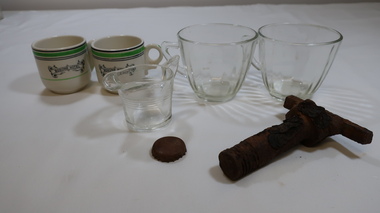 Kiewa Valley Historical Society
Crockery - Bogong Hotel
Bogong Hotel at Tawonga. See KVHS 0965, KVHS 0991 - KVHS 0993 inclusive.Bogong Hotel an important social icon for Kiewa Valley farmers, visitors, and KHES workers. The Bogong Hotel was 125 years old when it was burnt down in December 2011.1. 2 small china cups- white with black and green lines around the top and 'Bogong Hotel' logo 2. 2. glass cups with a handle. Glass is smooth on outside and has vertical 'waves' on inside 3. 1 small glass jug with handle and pouring lip. It has 5 rings of embossed glass around it 4. 1 burnt fire valve handle - T shaped for attaching to a surface 5. burnt bottle topbogong hotel, tawonga, crockery, fire at bogong hotel -
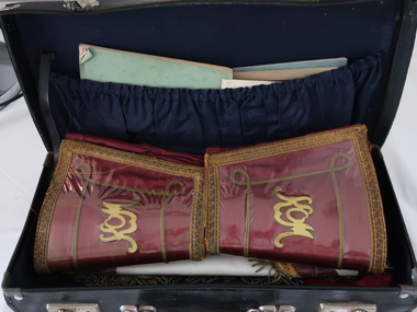 Kiewa Valley Historical Society
Royal Antediluvian Order of Buffaloes Member's Case
Originated in the United Kingdom in 1822 with a motto "No man Is At All Times Wise" and a maxim of "Justice, Truth and Philanthropy". A branch of the Royal Antediluvian Order of Buffaloes was formed at Bogong by Grand Lodge Officers from Melbourne and other members. The ceremony was held at Lewis Camp Mess (Kiewa Hydro Electric Scheme) with a world record of 78 new members initiated and a world record of over 100 pounds was raised. Another branch, No. 150 was opened in Mt Beauty. The Bogong and Mt Beauty lodges combined in 1948 and organised a Christmas treat for all children of the State Electricity Commission of Victoria working on the Kiewa Hydro Electric Scheme.Historical: The Bogong R.A.O.B. was formed circa Sept. 1946 and the Mt Beauty R.A.O.B. in 1948. It was a popular organisation in Bogong and then in Mt Beauty during the construction of the K.H.E.S. This club shows how important social clubs were in making up part of the community thus making it socially historic as well. It was a voluntary charitable organisation with a complicated ceremonial tradition and enjoyed by its participants. The donor, Brian William John Bourke was a cook at the pub and other places around the town. He had lived in the area since the 1950s and passed away 2019 and is buried at Tawonga Cemetery.Small brown leather case with attached handle and sliding clips on each side. The corners are reinforced with steel.The hinge appears to be stitched on and is held by an attached leather strap on the right side. Inside: the lid has a material open gathered pocket holding 4 small books and 4 thin booklets / papers. The case holds 2 large leather red and gold cuffs, 1 red with gold decoration apron, 1 red ribboned necklace with a personal badge and 1 of the lodge and 2 short ribbons (one green and 1 blue) with badges attached including the Mt Beauty badge on horns. 1 cardboard roll with B W J Bourke / Mt Beauty on the outside and 4 certificates rolled inside. These are dated 1964, 1970, 1974, 1974 . See also KVHS 0084, KVHS 0945, KVHS 1441 Brian William John Bourkeroyal antediluvian order of buffaloes, bogong, mt beauty, charitable organisation, lewis camp mess, r.a.o.b. -
 Falls Creek Historical Society
Photograph - SEC hut - home to Skippy and Toni St. Elmo
Mavis Grace Lindsay born in 1917 and married Toni St. Elmo in Ballarat on 18 December 1944. She was known as “Skippy” from childhood. They moved from Melbourne in 1945 and spent the year living in Wallace’s Hut. Toni was employed by the State Electricity Commission to record weather-related data. They were to become responsible for early developments at the Falls Creek resort and for promoting a love of skiing. Toni taught Skippy to ski and she practised on the High Plains where she and her husband lived. Toni entering her in the first club championships held by the Bogong Ski Club at Rocky Valley, which he had established. Skippy St Elmo won many ski races during the 1950s and represented Australia in New Zealand. In 1947, the first ski lodge was built by six SEC employees including Toni St Elmo. The lodge was named “Skyline”. In 1957, Toni was involved in building the first rope tow at Falls Creek, called Nissen. He also established the Nissen Ski School. In 1949, Skippy won the Downhill and Combined State Championship held at Mt Buller. In 1950, Skippy was selected to compete in New Zealand with the Victorian team. Skippy trained with the men at the Bogong Ski Club which became a talking point in 1953 when the Albury Ski Club held an Open Championship and Skippy won in the Giant Slalom and Downhill. She went on to win many more races. In 1960, Skippy and Toni said farewell to Falls Creek. Skippy passed away in Queensland in July 2005 and Toni passed away in September of the same year. In November 2006 they were honoured at the Alpine Village at Falls Creek by the spreading of their ashes over Eagle Rock.A black and white photograph of Skippy and Toni St. Elmo standing in the doorway of their hut on the Bogong High Plains. A line of washing stretches behind the hut connected to the outside toilet.skippy st. elmo, toni st. elmo, sec hut skippy and toni st. elmo -
 Falls Creek Historical Society
Photograph - Skippy St Elmo and the Ski Club of Victoria Junior Test
Mavis Grace Lindsay born in 1917 and married Tony St. Elmo in Ballarat on 18 December 1944. She was known as “Skippy” from childhood. They moved from Melbourne in 1945 and spent the year living in Wallace’s Hut. Toni was employed by the State Electricity Commission to record weather-related data. They were to become responsible for early developments at the Falls Creek resort and for promoting a love of skiing. Toni taught Skippy to ski and she practised on the High Plains where she and her husband lived. entering her in the first club championships held by the Bogong Ski Club at Rocky Valley, which he had established. Skippy St Elmo won many ski races during the 1950’s and represented Australia in New Zealand. In 1947, the first ski lodge was built by six SEC employees including Toni St Elmo. The lodge was named “Skyline”. In 1957, Toni was involved in building the first rope tow at Falls Creek, called Nissen. He also established the Nissen Ski School. In 1949, Skippy won the Downhill and Combined State Championship held at Mt Buller. In 1950, Skippy was selected to compete in New Zealand with the Victorian team to compete in New Zealand Skippy trained with the men at the Bogong Ski Club and that fact became a talking point in 1953 when the Albury Ski Club held an Open Championship and Skippy won in giant slalom and downhill. She went on to win many more races. In 1960, Skippy and Toni said farewell to Falls Creek. Skippy passed away in Queensland in July 2005 and Toni passed away in the September of the same year. In November 2006 the pair was honoured at the Alpine Village at Falls Creek by the spreading of their ashes over Eagle Rock.Photograph of Ms Skippy Elmo and man at Bogong High Plains on August 25 1945 as well as a framed receipt for the Ski Club of Victoria Junior Test for Ski Instructorsskippy st elmo, skyline lodge, bogong high plains, ski instructor test -
 Kiewa Valley Historical Society
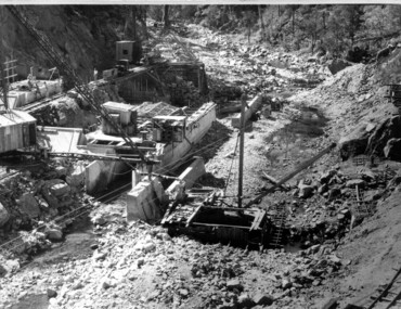
Black and white photograph of Surveyor's Camp, 1938, Kiewa River and surveyor's Camp 25/8/38, 25/08/1938
Surveying under the prevailing conditions at this time was an arduous and demanding task. There were no roads beyond Tawonga and access was by bridle tracks, on foot or horseback. This camp was to provide accommodation to those men who were surveying the road from South Tawonga to the Bogong High Plains which was commenced in April, 1938. The actual work was undertaken by the Country Roads Board, on behalf of the State Electricity Commission, using three Caterpillar diesel crawler tractors equipped with Kay Bruneriei (Brunner) lhydraulically operated trailbuilders (angle dozers)This photograph shows the primitive living conditions that were endured by those carrying out the initial field investigations and surveys for the Kiewa Hydro Electric Scheme. It is possibly one of the few photographs in existence of this camp and of the very rustic timber foot bridge across the West Kiewa river. It has been taken from approx. 100m up Simmonds Creek Road. A black and white photograph showing a small, timber foot bridge across the West Kiewa River. There is a man standing on the bridge and two small huts on the far side of the river, against a backdrop of Mt. Beauty and Mt. Bogong.At the top of the photograph, handwritten in black ink is the inscription "Kiewa River and Surveyor's Camp 25/8/38". The number 4 is stamped towards the right upper corner. On the back, in a circle, about 1.3cm in diameter, are the words "Kodak Print". The word "Velox" is faintly discernible on the back as well.surveyor, tawonga, west kiewa river, bridge, camp, secv -
 Kiewa Valley Historical Society
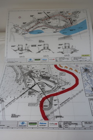
Plans - Southern Hydro - Bogong Power Development
Southern Hydro owned the Kiewa Hydro Electric Scheme in May 2006 when these plans were created. The Site No. 1 and Site No. 2 are part of the Bogong Power Development Bogong Power Development is part of the Kiewa Hydro Electric SchemeLaminated A3 plans mostly black and white but with a little color and surrounded by a grid.(Also see KVHS 1439) 1. Tunnel and Civil works / Commissioners Lodge Site Plan 1: Site No. 1 / TBN /Water /Supply / Reservoir Site 2. Tunnel and Civil Works / Pedestrian Diversion Access Paths / and Tracks: Site No. 2 / Lake Guy Site / Bogong Victoriabogong power development, southern hydro 2006 -
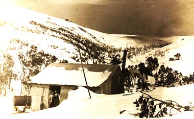
 Kiewa Valley Historical Society
Photos - Junction Dam Spillway, Kiewa Hydro Electric Scheme
2 black and white small photos titled - A. 'Bogong Village, Kiewa Hydro Electric Project' and B. 'Junction Dam & Spillway, Lake Guy, Bogong, Kiewa Hydro Electric Project' -
 Kiewa Valley Historical Society
Photos: Bogong Hotel and Kiewa Valley
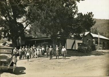
The Bogong Hotel was a central point for social gatherings in the Kiewa Valley. It was 125 years old when it was burnt down in December 2011. See KVHS 0965See KVHS 0965Black and white photos framed with thick brown cardboard that is framed by two rows of lines around the photo thus forming a frame. The cardboard is folded in half to form a 'card' enabling the photo to stand. 1. People standing outside the Bogong Pub. The pub is behind trees. Two old/vintage cars are partially in the photo. 2.The Kiewa Valley showing paddocks, trees lining the Kiewa River and mountains in the background.bogong pub, kiewa valley -
 Kiewa Valley Historical Society
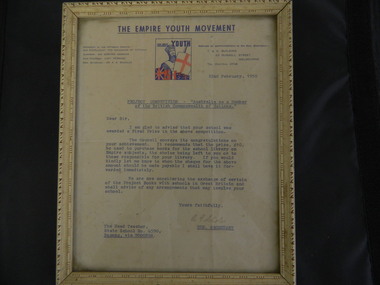
Framed Letter - Bogong State School, 1950
In 1950, the "Project Competition - Australia as a Member of the British Commonwealth of Nations" was conducted. Bogong State School was awarded a First Prize in the competition. The prize being 10 pounds to be used to purchase books for the school library on Empire subjects. Bogong is a local town established by the State Electricity Commission of Victoria during the construction of the Kiewa Hydro Electric Scheme. This letter is significant in that it shows that the British Empire was very relevant to the population at the time and being promoted in schools.Cream decorated frame with glass front and paper backing. Two rings are screwed into the top sides of the back of the frame with one plastic cord and one piece of string between them. The framed letter is titled 'The Empire Youth Movement", dated 22nd February, 1950 and addressed to the Head Teacher of the Bogong State School. Blue print with colored square in the middle at the top. bogong state school; empire youth movement; certificate -
 Kiewa Valley Historical Society
Bibs - Bogong Primary School
Bogong Primary School opened in 1941 to provide an education for the employees of the State Electricity Commission of Victoria. The school had up to date equipment and received glowing reports from school inspectors. It closed c1986.The Bogong State School was opened for the children of S.E.C.V. workers who lived in Bogong in a remote part of north east Victoria. The nearest school would have been 14 miles away and over mountain roads subject to heavy construction traffic and extremes of climatic conditions.6 bright orange 'bibs' from Bogong Primary School. Used to identify a team in eg. sport. Each bib has 2 coloured squares which are hemmed and joined to each other with 2 elastic pieces on the outside at the top (to fit over the head) and on each square joining the 2 squares, 2 white bias binding pieces on the outside at the bottom (for the arms to go through.)team bibs. bogong primary school. education. state school. -
 Kiewa Valley Historical Society
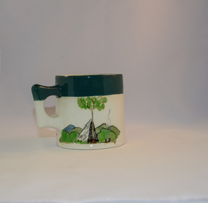
Mug Stoneware
This ceramic mug is titled "Bill Bogong's Mug" in honour of one of Australia's Scouting (Rovers) notable office holders, Mr.W.F."Bill" Waters. He was born on 22nd August 1897 in Taralgon, Victoria, Australia and died 8th October 1968 in Fitzroy, Victoria. He was instrumental in the Rovers building two chalets in the Victorian Alps. The Victorian Award of the National Rover Service Award(1980) has been named after Bill Waters. Bill Waters was also the leader of the first team that climbed Mount Bogong in winter in 1929. Also was part of rescue team of what is now know as the Cleve Cole tragedy on Mt Bogong in the mid 1930's. There is also a water fall named after him Waters Falls on the Bogong High Plains. W.F."Bill" Waters aka "Bill Bogong" (Bogong mountain, were his ashes were scattered), was not only a prominent bush walker (Melbourne Walking Club) of the high country (Victorian Alps) but was instrumental in establishing two Chalets. One of these Chalets was the first one to be built on the Bogong High Plains. This item, "Bill Bogong's Mug" is what the Flinders Petrie(famous English Egyptologist/Archaelogist) Rover Crew(formed in 1940) presented newly invested members of the exclusive(200 membership) Alpine Rover Crew. The Melbourne Walking Club has a long history with the Victorian High Plains area, of which the Kiewa Valley is an integral part of the Victorian Alpine Region. Due to the connections Bill Waters has with the Bogong High Plains and Mt Bogong this cup has a lot of significance to the social history of the area.. Round glazed stoneware mug, white in colour, with a heritage green coloured band covering the top rim and handle. Written inscription on the front "Bill Bogong's Mug" in large print and beneath it, in smaller print, "with compliments from Flinders Petrie Rover Crew" The other side of the mug is a free hand landscaped drawing of green bush and blue hills with a tree supporting a tent and a camp fire (with smoke rising from it).To the left of the inscription is the Scout (Rover) emblem coloured black with an unraveled and unwritten signage scroll fowler ceramics, local alpine history, alpine rovers, scouts, mugs, mt bogong, bogong high plains