Showing 1723 items
matching county
-
 RMIT GSBL Justice Smith Collection
Book, Victoria. Parliament. Law Reform Committee, De Novo appeals to the County Court : Law Reform Committee, 2006
ISBN: 0975798421victoria. county court, appellate procedure -- victoria, criminal procedure -- victoria, justice, administration of -- victoria -
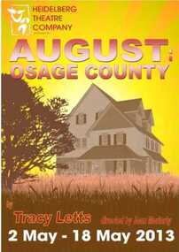 Heidelberg Theatre Company Inc..
Program Photos Reviews Newsletter Poster Articles, August : Osage County by Tracy Letts directed by Joan Moriarty
2013, 394 -
![Drawing, Lamb [Charles?], 'Bow County Court'](/media/collectors/530576742162ef0fa09a2288/items/534748169821f420f8c038c3/item-media/5afbcfeb21ea6c07a469584e/item-fit-380x285.jpg) Federation University Art Collection
Federation University Art CollectionDrawing, Lamb [Charles?], 'Bow County Court'
This item is part of the Federation University Art Collection. The Art Collection features over 1000 works and was listed as a 'Ballarat Treasure' in 2007.art, artwork -
 University of Melbourne, Burnley Campus Archives
Plan, Burnley Gardens. City of Richmond. Parish of Jika Jika - County of Bourke, 1927
Part-coloured plan showing drainage, sewerage drains, taps and waterstops. Area bounded by Swan St. To N, Yarra River on E and Richmond Park on SW side. Contour lines of orchard depicted, laying pens and yards. Coloured area depicts pavilion with surrounding garden and paths layout pencilled in. Photo-Lithograph by Dept. of Lands & Survey, Melbourne by W. Butsonsewerage, drainage, lithograph, pavilion -
University of Melbourne, Burnley Campus Archives
Plan, Burnley Gardens. City of Richmond. Parish of Jika Jika - County of Bourke, 1927
Plan showing Burnley Gardens - bounded by Swan St to N, Yarra River to E, Richmond Park on S and W side. Photo-lithographed at Dept. of Lands & Survey by W.J. Butson. Plan shows old orchard, fowl sheds, coops and yards, milking shed, silo, nursery, glasshouse, fattening pens, dairy, garden, orchards area in S.W. area.burnley gardens, orchards, sheds, nursery -
University of Melbourne, Burnley Campus Archives
Plan, Burnley Gardens. City of Richmond. Parish of Jika Jika - County of Bourke, 1927
Plan showing Burnley Gardens - bounded by Swan St to N, Yarra River to E, Richmond Park on S and W side. Photo-lithographed at Dept of Lands & Survey by W.J. Butson. Plan shows old orchard, fowl sheds, coops and yards, milking shed, silo,nursery, glasshouse, fattening pens, gardens and orchards area in S.W. corner.burnley gardens, orchards, sheds, nursery -
University of Melbourne, Burnley Campus Archives
Plan - Photocopy, County, c.1930
Given to Archives by Emma Ferguson and Jo van Berkel who used it in preparation of their 1994 thesis on the history of the Burnley Gardens. Photocopy of a plan depicting Burnley College as it was in the 1930's. It shows the Pavilion and surrounding gardens, coops and yards, various small outbuildings. Shows the contours of the land in the northern section of the property bordering Swan St. Some additions and comments have been added to original document, mainly to do with sewerage and water supplyburnley college, pavilion, emma ferguson, jo van berkel -
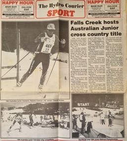 Falls Creek Historical Society
Article - Falls Creek Hosts Australian Junior Cross County Title
Falls Creek was selected as the venue for the 1994 Kinetix Australian Junior Championships in Cross Country Skiing in 1994. The event was held on the 2nd and 3rd of September. It was attended by over 100 skiers from Victoria, New South Wales, ACT and the United States. Several local skiers performed well, reinforcing North East Victoria as a force in cross country skiing. Nearly 30 teams competed in the Australian Interstate Junior Relay Championships in the final event. To top the events off a huge snowball fight broke out between skiers and officials, showing good fun could be had between rival teams. The event was organised by the Birkebeiner Nordic Ski Club.This article is significant because it records the holding of a major event at Falls Creek.An article covering pages 11 and 12 of "The Hydro Courier" containing images and text. It was published on September 13, 1994 and the images were taken by Falls Creek Photo Service.junior cross country 1994, falls creek events, hydro courier, summit masters, birkebeiner nordic ski club -
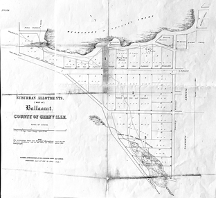 Friends of Ballarat Botanical Gardens History Group
Work on paper - Suburban Allotments (west of) Ballaarat, Wendouree or Yuille's Swamp, County of Grenville 30/4/1856, 30/4/1856. No date given for photocopy
This map of the 1856 survey shows the numbered suburban allotments and the boundaries surrounding this area including Wendouree or Yuilles's Swamp close to where the Ballarat Botanical Gardens and the Lake exist today. This map gives a clear idea of an early survey of this western area and directions to areas of Ballarat surrounding these allotments.2 pages of the same map, except p.2 shows the Township Reserve on the lefthand side of the page. On the back of p.2, righthand corner is the Public Records Stamp.P2, righthand corner is the citation in pencil.john garner, doctor john garner, ballarat botanical gardens, friends of ballarat botanical gardens, map of western suburban allotments 1856, county of grenville, public record office of victoria, john garner collection, gardens, ballarat -
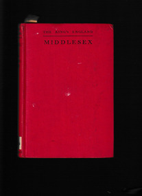 Mrs Aeneas Gunn Memorial Library
Book, Hodder & Stoughton, Middlesex, little home county, 1940
A description of the county of MiddlesexIndex, ill, map, p.232.A description of the county of Middlesexmiddlesex - description, middlesex - travel -
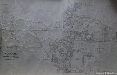 Melton City Libraries
Map, Coimadai County of Bourke, 1911
Town Plan of Meltoncouncil -
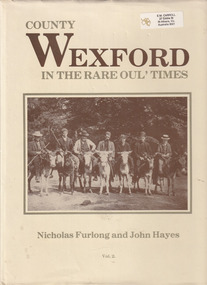 The Celtic Club
Book, Old Distillery Press Wexford, County Wexford in the rare oul' times, 1987
The second volume of the earliest photographs of County Wexford.Ill., plates, p.183.non-fictionThe second volume of the earliest photographs of County Wexford.county wexford 1924-1994 - social life and customs, wexford - ireland -
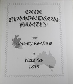 Wodonga & District Historical Society Inc
Book - Our Edmondson Family - from County Renfrew to Victoria 1848, Rob Mortlock, Bob Polkinghorne, Lorna Polkinghorne
This history of the Edmondson family begins with the journey of George and Isabella Edmondson, with their four children, from County Renfrew via Liverpool to Melbourne in 1848. After some time at the Bendigo goldfields, George and his second wife, Margaret Boyd, moved to the Yackandandah area. Later family members settled in various areas of Victoria, with one descendant, Ern Edmondson being a member of the ANZAC forces. Particular mention is made of Maud Cadman, an octogenarian family member, and source of much family information. The story is profusely illustrated with photographs of family members, and, in particular, a photograph of a New Testament, presented to Margaret Boyd aboard the ship that brought her to Australia in 1852.non-fictionThis history of the Edmondson family begins with the journey of George and Isabella Edmondson, with their four children, from County Renfrew via Liverpool to Melbourne in 1848. After some time at the Bendigo goldfields, George and his second wife, Margaret Boyd, moved to the Yackandandah area. Later family members settled in various areas of Victoria, with one descendant, Ern Edmondson being a member of the ANZAC forces. Particular mention is made of Maud Cadman, an octogenarian family member, and source of much family information. The story is profusely illustrated with photographs of family members, and, in particular, a photograph of a New Testament, presented to Margaret Boyd aboard the ship that brought her to Australia in 1852.edmondson family, pioneers, beechworth, yackandandah, northeast victoria family history -
 Bacchus Marsh & District Historical Society
Map, Village allotments, Parish of Myrniong, County of Bourke
Myrniong is a village 9 kilometers west of Bacchus Marsh. Prior to 1863 the area was known as Blow's Flat. This map which was produced in 1903 and according to the catalogue record of this map held at the State Library of Victoria was based on an earlier map created in 1861. The early layout of streets for the village of Myrniong can be seen on this map. The streets shown are, Main Street, Hardy Street, Blow Street, Myrniong Street, Shuter Street, and Blackwood Street. An area marked as a reserve for a school can be seen between Hardy Street and Main Street.A single page paper map. A cadastral parish map of Myrniong in Victoria, showing numbered land allotments. Photo-lithographed at the Department of Lands & Survey, Melbourne, in 1903. Based on an original map created in 1861. The map is pasted into a bound volume containing 76 maps or plans in total. High resolution digital image stored on BMDHS computer network. Surveyed by John Hardy, Surveyor ; photo-lithographed at the Department of Lands & Survey, Melbourne by T.F. McGauran, 24.12.03myrniong parish plan, myrniong parish maps -
Lakes Entrance Historical Society
Book, Stevens M I, Township of Cann River, Parish of Noorinbee, County of Croajingolong, 1977
An account of the development of the Cann River town and district in Gippsland, Victoria, compiled for the 50th. anniversary of the Cann River school. Includes list of pupils and head teachers, information on other schools, and recollections of residents.settlers, schools, township -
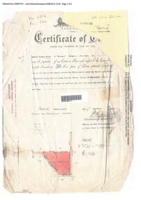 Ringwood and District Historical Society
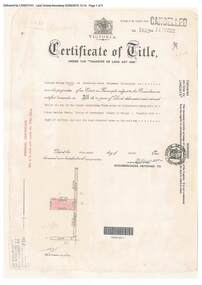
Document, Certificate of Title - Edward Thomas Miles, Gentleman, "Woorara", Ringwood - part of Crown Section 20, Parish of Warrandyte, County of Evelyn - 1913
A4 copies of damaged Landata Victoria Historical Search documents - Vol 3726 Fol 200 - incomplete proprietor and transfer details.Edward Thomas Miles is now the proprietor of an Estate in Fee-simple subject to the Encumbrances notified hereunder ... 27 acres 19 perches or thereabouts, together with a right of carriage way over roads coloured brown. Subdivision map includes un-named roads - western side is Wonga Road (later Warranwood Road), and eastern side is Grandview Grove (later Bemboka Road), both north of Plymouth Road, Ringwood, Vic. Transfers include (illegible) Dobbs, November, 1927 - 5 acres Harry Temple Marshall, 1st December, 1928 - 10ac 3r David Edward Meyland, 4th October, 194-? (illegible). -
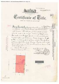
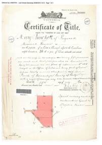 Ringwood and District Historical Society
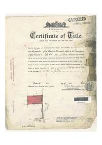
Document, Certificate of Title - Mary Burchett, Lilydale Road, Ringwood - part of Crown Section 20, Parish of Warrandyte, County of Evelyn - 5th July, 1911
A4 copies of Landata Victoria Historical Search documents - Vol 3520 Fol 703990.Mary Burchett of Ringwood, Married Woman, is now the proprietor of an Estate in Fee-simple subject to the Encumbrances notified hereunder ... 50 acres 1 rood 32 perches or thereabouts, being lots 1 and 10 on plan of subdivision no.4315. Subdivision map includes un-named roads - western side is Wonga Road (later Warranwood Road), and eastern side is Grandview Grove (later Bemboka Road), both north of Plymouth Road, Ringwood, Vic. Title transferred to Theodore Hartley Burchett, 27th July, 1911. Encumbrance comment "Special railway condition contained in Grant to Francis Cooke." -
 Bacchus Marsh & District Historical Society
Map, Balliang Parish Map, County of Grant c.1907
A single page paper map showing parish plan map for Balliang. This parish area contains the localities of Balliang and Balliang East and is located south of the township of Bacchus Marsh. The map is pasted into a bound volume containing 76 maps or plans in total. High resolution digital image stored on BMDHS computer network. balliang victoria maps, balliang parish maps -
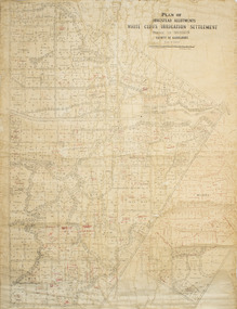 Merbein District Historical Society
Plan - Plan, Allotments, Plan of Homestead Allotments White Cliffs Irrigation Settlement Parish of Merbein County of Karkarooc
Large plan drawn in black ink on cream colour paper with linen backing. Some red ink addedWritten in red pen new owners of allotmentsallotments, merbein, irrigation, whitecliffs, county of karkarooc -
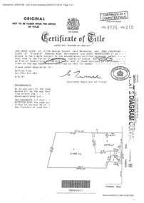 Ringwood and District Historical Society
Document - Certificate of Title and Maroondah Heritage Study, "Elouera", 59 Bemboka Road, Warranwood, Victoria, previously part of Crown Section 20, Parish of Warrandyte, County of Evelyn - 4th February, 1987
Property subsequently subdivided into residential allotments with formation of Aspen Court, Warranwood, circa 2010.A4 copies of Landata Victoria documents - Vol 9725 Fol 210 derived from Vol 9701 Vol 469, and 2-page Heritage Study report.Ian Vance Lloyd and June Josephine Lloyd are joint proprietors of an estate in fee simple - Lot 4 on Plan of Subdivision no.204137B shown on the map. Subdivision includes Bemboka Road. Encumbrance E-1 later extended through Lot 4 as Aspen Court. Transfer - Proprietor June Josephine Lloyd - 29 July, 1993. Documents include 2-page Heritage report for study conducted prior to subsequent Aspen Court residential development circa 2010. -
University of Melbourne, Burnley Campus Archives
Plan (Item), Plan of Burnley Gardens, City of Richmond, Parish of Jika Jika, County of Bourke, 1948
(On original) : Notes by W(?) Anderson 28/2/45. Date stamp of School of Primary Horticulture and Agriculture Burnley E1burnley gardens, richmond, department of lands & survey, orchard -
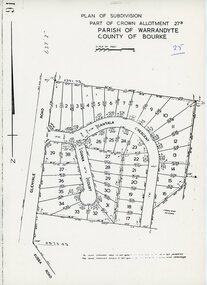 Ringwood and District Historical Society
Map - Plan of Subdivision, Part of Crown Allotment 27B Parish of Warrandyte County of Bourke (undated, circa 1970)
Photocopied subdivision map of 38 residential allotments in Glenvale Road, Cantala Crescent, and Giana Court, north of Kubba Road, Ringwood. -
 Ringwood and District Historical Society
Document, Certificate of Title - W.G. Carter, Grandview Grove, Warranwood, Victoria, (later Bemboka Road) - part of Crown Section Twenty, Parish of Warrandyte, County of Evelyn - 1947
A4 copies of Landata Victoria Historical Search documents - Vol 7052 Fol 1410222. Includes Carter Family Tree property notes. William George Carter of Grandview Grove Ringwood, Nurseryman, is now the proprietor - three acres or thereabouts shown on map (12202a) - 14th March, 1947. Transfer B284834 Registered 21 September, 1961 - 1 acre shown on map (12202c) north of Plymouth Road. NOTES ON GRANDVIEW GROVE PROPERTY (Carter Family Tree extract) The Grandview Grove property was purchased by William (Bill) and Doreen Carter in 1947 as three acres of uncleared bushland. They had a 2 bedroom fibro-cement house built on the land which they informally called "Willoreen". With Doreen looking after sons Peter (born in 1940) and Robin (born in 1950), Bill worked locally at Croydon Dairy. The family spent much of their spare time clearing the land, where Bill then grew and sold fruit, flowers and berries, particularly strawberries, as a hobby and to supplement their income. Bill continued to do so while Peter and Robin were growing up, and after Doreen died in 1958. In 1961 Bill sold one of the three acres to one of his seven sisters, Grace, who lived in Kew but later moved to Rosebud and sold the land without ever building on it. During the 1960s, Grandview Grove was renamed Bemboka Road. After retiring as a milkman, Bill moved to Rosebud, Vic, and in 1977, sold the property to the Anglican Church, who were looking to invest in the site in anticipation of proposed future residential development in the area. As nearby properties were subdivided during the 1980s, the house, which the Church had initially utilised as low-cost family accommodation, was modified internaly to become a church/Sunday school. By the early 2000s, construction of a contemporary-design church and carparking area between the house and street alignment had been completed but the house remained as a detatched meeting room until falling into disrepair and was eventually demolished around 2010. -
 Ringwood and District Historical Society
Document, Certificate of Title - Thomas Arthur Wentworth Burkitt - part of Crown Section 20, Parish of Warrandyte, County of Evelyn - 1st April, 1919
A4 copies of Landata Victoria Historical Search documents - Vol 4197 Fol 839286.Winifred Cambridge of Balwyn, Married Woman, is now the proprietor of an Estate in Fee-simple subject to the Encumbrances notified hereunder ... 17 acres 2 roods 3 perches or thereabouts, being part of Lot 9 on plan of subdivision no.4315, Bemboka Road, Warranwood, Victoria. Encumbrance comment "Appurtenant to carriageway over Omeo Parade on LP12040". Transfers include John Collins of Brysons Road Ringwood, Farmer - 16th June, 1944, Kevin Collins of Warranwood, Carrier - 20th September, 1951, Francis Mohan of St.Kilda - 19th January, 1968, Vivian Campbell Rush, Engineer, and Dorothy May Rush, Married Woman, both of Main Road, Warrandyte, joint proprietors, and Alan Humphrey Croxford, Gentleman, and Eleanor Pearl Croxford, Married Woman, both of Pound Road, Warrandyte, joint proprietors as Tenants In Common - 31st March, 1969, Transferred as to the interest of Alan Humphrey Croxford and Eleanor Pearl Croxford - 13th July, 1973. (See Alan Humphrey Croxford biography link https://adb.anu.edu.au/biography/croxford-alan-humphrey-12375) -
Clunes Museum
Map, Township of Clunes - Parish of Clunes - County of Talbot
Map of Clunes Township in 19511 X PHOTOCOPY OF MAP, (COMPRISING A NUMBER OF A4 SHEETS TAPED TOGETHER) SHOWING LOT NUMBERS AND NAMES OF LANDHOLDER. REFERENCE GAZ 1951.1480. SCALE 30 CHAINS = 1 INCH 1 X PHOTOCOPY OF MAP, (COMPRISING A NUMBER OF A4 SHEETS TAPED TOGETHER) SHOWING LOT NUMBERS AND NAMES OF LANDHOLDER. REFERENCE: G76359 GENERAL FILE TOWNSHIP RESIDENTIAL ALLOTMENTS SCALE 30 CHAINS = 1 INCHNOTATED IN PURPLE CRAYON ON SECOND MAP: AS AT LATE 1984 COPY OF MAP FROM LAND TITLES OFFICE BALLARATtownship of clunes map, 1951 -
 Ringwood and District Historical Society
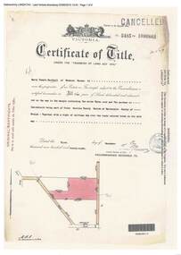
Document, Certificate of Title - Harry Temple Marshall, Wesburn Farmer, Vic. - part of Crown Section 20, Parish of Warrandyte, County of Evelyn - 1928
A4 copies of Landata Victoria Historical Search documents - Vol 5485 Fol 1096803. Harry Temple Marshall is now the proprietor of an Estate in Fee-simple subject to the Encumbrances notified hereunder ... 10 acres 3 roods 10 perches or thereabouts, together with a right of carriage way over roads coloured brown. Subdivision map includes un-named roads - western side is Wonga Road (later Warranwood Road), and eastern side is Grandview Grove (later Bemboka Road), both north of Plymouth Road, Ringwood, Vic. Transfers include Harold Claude Howship, 1st December, 1928 James Bell McAlpin, 26th March, 1939. -
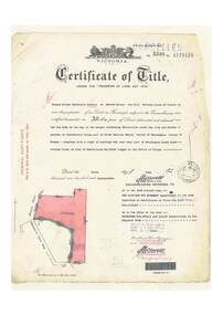
 Ringwood and District Historical Society
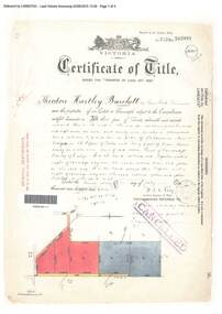
Document, Certificate of Title - Theodore Hartley Burchett - part of Crown Section 20, Parish of Warrandyte, County of Evelyn - 1911
A4 copies of Landata Victoria Historical Search documents - Vol 3520 Fol 703991.Theodore Hartley Burchett of Lara Lake, Farmer, is now the proprietor of an Estate in Fee-simple subject to the Encumbrances notified hereunder ... 180 acres 01 rood 27 perches or thereabouts, being lots 1, 8, 9 and 10 on plan of subdivision no.4315. Subdivision map includes un-named roads - lower western side is Wonga Road (later Warranwood Road), and eastern side is Grandview Grove (later Bemboka Road), both north of Plymouth Road, Ringwood, Vic. Transfers include Anna Maria Wicks and Henry James Trowbridge, 3rd October, 1911 Elizabeth Ann Walden, 18th September, 1912 - 28ac 3rds 5per. Edward Thomas Miles, 22nd September, 1913 - 27ac 19per. Samuel Styles, 10th October, 1916 - balance. -
 Ringwood and District Historical Society
Document, Certificate of Title - Mary Burchett, Lilydale Road, Ringwood - part of Crown Section 20, Parish of Warrandyte, County of Evelyn - 14th January, 1910
A4 copies of Landata Victoria Historical Search documents - Vol 3398 Fol 679415.Mary Burchett of Lilydale Road, Ringwood, Married Woman, is now the proprietor of an Estate in Fee-simple subject to the Encumbrances notified hereunder ... 55 acres 3 roods 35 perches or thereabouts, being lots 8 and 9 on plan of subdivision no.4315. Subdivision map includes un-named road - Grandview Grove (later Bemboka Road, Warranwood, Vic). Title transferred to Theodore Hartley Burchett, 27th July, 1911. -
 Ringwood and District Historical Society
Document, Certificate of Title - Thomas Arthur Wentworth Burkitt - part of Crown Section 20, Parish of Warrandyte, County of Evelyn - 5th June, 1929
A4 copies of Landata Victoria Historical Search documents - Vol 5598 Fol 1119416.Thomas Arthur Wentworth Burkitt of Box Hill, Retired Clerk of Courts, is now the proprietor of an Estate in Fee-simple subject to the Encumbrances notified hereunder ... 35 acres 1 rood 11 perches or thereabouts, together with right of carriage way over part of Warrandyte Coach Road on plan of subdivision no.12040. Subdivision maps includes Brysons Road, Warrandyte Coach Road (later Wonga Road), Rangeview Parade (later Omeo Parade), and Kardinia Crescent, Warranwood. Mortgages and Transfers include Mortgate - part to the Trustees of Vic District no.82 I.O.O.R, 1st August, 1929, Mortgate - part to Arthur Edward Perry, 1st August, 1929, Transfer 1426692 - George Clements Dickason and Will Gordon Sprigg, 20th August, 1929, Transfer 1766662 - Linda Elizabeth Collins, 28th March, 1940. -
 Bacchus Marsh & District Historical Society
Map, Maddingley Township, Parish of Parwan, County of Grant, 1856
Maddingley is a locality or township within the broader township area of Bacchus Marsh. This map is dated 1856 but is based on an earlier survey in 1843. The main area of Maddingley shown on this map is an area bounded by Bacchus Street, Moore Street, Griffith Street and Franklin Street. Other streets visible are Inglis Street, Labilliere Street, McCrae Street. The area to the east of Franklin Street is not sub-divided and is described as an 'alluvial flat. A single page paper map showing land allotments, streets, and natural watercourses in the township of Maddingley. The map is pasted into a bound volume containing 76 maps or plans in total. Two inscriptions: 1. A.J. Skene Surveyor, 1843. ; 2. Surveyor-General's Office Melbourne, Sept 6, 1856. (Lithographed by R. Meikle)bacchus marsh victoria maps, maddingley victoria maps, land use, maddingley victoria history