Showing 1913 items matching "garden views"
-
 University of Melbourne, Burnley Campus Archives
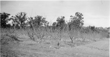
Photograph - Black and white and colour prints and negatives, Dept pf Agriculture, Victoria, Miscellaneous Burnley, 1942-1943
... of 6 men in an office, one is T. H. Kneen. (7) 18 garden views... of 6 men in an office, one is T. H. Kneen. (7) 18 garden views ...orchard, margaret bowron, betty williams, dept of agriculture, opium poppy, j l provan, t h kneen, geelong excursion, horses pulling lawnmower, ponds, greenhouses, trees, principal's residence, flying fox, j p mclennan, plants, draught horse, calf, students working outside, luffmann ponds, lily ponds, sequoia sempervirans, californian redwood, gardewn views, prunus glandulosa, magnolia stellata, petunia x hybrida -
 Bendigo Military Museum
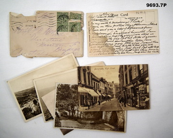
Postcard - ENVELOPE AND POSTCARDS WW1, C.1917
... .) Postcard, view of a well in a garden. .7) Postcard, street view... in a garden. .7) Postcard, street view in a town. Postcard ENVELOPE ...The postcards are addressed to the Mother of C.J.C. McQuie MM, all written in 1917. .2) Card talks about his leave plus sending a map home of the ground over where he was W.I.A. Card scene is Hele Beach Ifracombe. .3) "Combe Martin" .4) "The Torrs Walk Ifracombe. .5) "Ifracombe, Santern Hill & Hillsborough". .6) "The Dripping Well Barnstaple" .7) "Barnstaple High Street" Items in the collection relating to C.J.C. McQuie MM, refer cat No 9680P for his service details. All the postcards are in sepia tone. .1) Envelope light brown colour, has 4 green stamps, addressed in purple indelible pen. .2) Postcard, view across a valley, text on rear in black pen. .3) Postcard, view across a Valley, text on rear in black pen. .4) Postcard, view from Cliffs to Ocean, text on rear in black pen. .5) Postcard, view across Ocean to Hills. .6.) Postcard, view of a well in a garden. .7) Postcard, street view in a town..2) On rear, "14th Nov17, Royal Clarence Hotel Ifracombe" .3) On rear, "This is a view of Hillsborough" .4) On rear, "Walked around here yesterday & then to L...& Bull Pt Lighthouse" .5) On rear, "Royal Clarence Hotel Ifracombe 16/11/17 - Great views from the top of this hill - I am walking to Barnstable today, 12 miles from here"postcards, mcquie -
 Kew Historical Society Inc
Photograph - Peel Street Health Centre : Official Opening, 1930
... of a gay garden, and a lovely view of green fields sloping... of a gay garden, and a lovely view of green fields sloping ...The North Kew Centre was the third established at North Kew. It followed a lease of a house at 50 Willsmere Road. The Peel Street building was designed by Mr Chipperfield. Messrs McIntosh and Taylor were the successful tenderers, the price being 1,240 pounds. The North Kew Baby Health Centre was finally opened on 18 June 1930 in the presence of the mayor, councillors and citizens of Kew, and representatives of the Infant Welfare Council. A report in The Age of 19 June described the opening in detail as well as the features of the new Centre. These included: "The rooms ... filled with flowers, pink and mauve hydrangeas and native heath, and the walls are adorned, with a charming frieze, representing windmills, flocks and a fairy tale goose girl. On the walls are hygiene editions of the funniest of Belloc's "Cautionary Tales" revised as posters, Outside there is promise of a gay garden, and a lovely view of green fields sloping to a shining bend of the river." Early photographic record of the opening of an early baby health centre in Kew.[Badly damaged] black and white photograph of the opening of the North Kew Baby Health Centre in Peel Street. The photo is mounted on card, and shows mothers and their children on the veranda, and officials at right. The latter includes the Mayoress and probably Vera Scantlebury. All mothers wear hats as do most of the children. [When the photograph was presented to the Society in 1979, it was described in the first Acquisitions Register as framed. Some time after that it was removed from its frame and badly broken. A separate photocopy of the original photograph is also held in the collection.]Earliest inscription: "Peel Street Health Centre / Official Opening 1930 / donated by Sr Costello and Sr Bewish [sic] 1979 / Copy purchased by ..... for Centre". Old Accession number in Texta: "KH-133 Kew Historical Society". Separate later label: "Opening North Kew Baby Health centre 1930". north kew baby health centre, peel street (kew), baby health centres - kew (vic) -
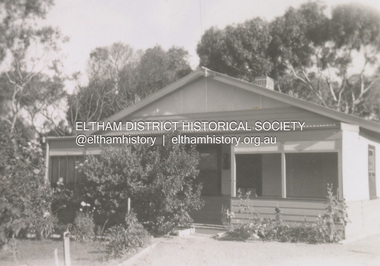
 Eltham District Historical Society Inc
Photograph - Digital Photograph, Marguerite Marshall, Eltham Retirement Centre (Judge Book Memorial Village), Diamond Street, Eltham, 23 October 2006
... the Eltham Lodge Nursing Home with each room having a garden view... the Eltham Lodge Nursing Home with each room having a garden view ...Thousands of elderly people at this centre have contributed much. Published: Nillumbik Now and Then / Marguerite Marshall 2008; photographs Alan King with Marguerite Marshall.; p161 Thousands of elderly people, who have contributed much to Nillumbik and beyond, have made their home in the treed Eltham Retirement Centre. The centre, which opened in 1956, has housed the disadvantaged in particular, through good times and hard, including floods, fire and even burglaries. As part of the Melbourne Citymission, a non-denominational Christian organisation that cares for people living with disadvantage, the centre was built to celebrate 100 years of the Melbourne Citymission’s work since 1854. Standing on a former poultry farm called Willandra (Still Waters), the centre includes independent units, hostel, nursing home accommodation and a Day Therapy Centre, which is available for non-residents as well. Despite being metres from the busy Main Road and railway station, the centre provides a quiet oasis on 6.8 hectares bordered by the Diamond Creek to the west, and the railway line to the east. The centre was originally named Judge Book Memorial Village after Judge Clifford Book, Deacon of the Collins Street Baptist Church. Book was also President of the Baptist Union of Victoria and Grand Master of the Masonic Lodge. He was so respected that, at his death, several Pentridge prisoners asked to attend his funeral. In 1993 the centre’s name was changed to clarify that it was part of the Melbourne Citymission. However Judge Book’s name continues in the Judge Book Memorial Garden, opened in 2006. The Diamond Creek has flooded the centre several times, however rarely causing serious damage. Volunteer Alan Field recalls a flood in 1974 when the resident manager Reverend Norman Pearce and his wife, were rescued by boat from their home with their budgerigar. On February 3, 2005, when the creek almost flooded Metzner Hall, 35 ambulances evacuated residents to nearby nursing homes, hostels and local homes. Residents were also evacuated during the 1965 bush fire, but fortunately a change of wind direction saved the centre. Residents have also endured several burglaries. Despite much rebuilding and modernisation over the years, traces of the original farmhouse remain in the administration areas. In 1991 the Willandra Hostel was built and in 2001 the Eltham Lodge Nursing Home with each room having a garden view. Several buildings are named after people who have given special service to the centre including the Norman Pearce Day Hospital after general manager and pastor Rev Pearce. Metzner Hall was named after the Metzner family who had been active in the auxiliary since it began and had donated generously to the Recreation Hall fund.3 A bridge was named after Sister Lila Murray who had worked at the village for 42 years in various capacities including as relieving manager. Field remembers Sister Murray as ‘the Mother Teresa and soul of what the village aspired to, with love and care’. Since 1957 the Eltham Auxiliary, later called the Residents’ Association, has worked to improve the residents’ quality of life by volunteering and raising funds. An outstanding volunteer, Field, who was drawn to the centre in 1971 with his wife Chris, has held positions on the early Eltham boards, auxiliaries and Residents’ Association. Much of his work has been supporting people with no family and those of limited means. He says he and his wife look at their work as having shared ‘our lives with amazing people’. The wealth of experience and wisdom in the Retirement Village has benefited many people, including local school children. Residents have acted as proxy grand-parents at local schools, by assisting small learning groups or telling their life stories. Conversely, students from local schools have visited to perform, or to assist in programs like craft activities. Resident Val Bell, whose mother Rose Bullock lived at the centre before her, sums up the centre’s most important attribute for her: ‘The Christian care. They could not be more caring’.This collection of almost 130 photos about places and people within the Shire of Nillumbik, an urban and rural municipality in Melbourne's north, contributes to an understanding of the history of the Shire. Published in 2008 immediately prior to the Black Saturday bushfires of February 7, 2009, it documents sites that were impacted, and in some cases destroyed by the fires. It includes photographs taken especially for the publication, creating a unique time capsule representing the Shire in the early 21st century. It remains the most recent comprehenesive publication devoted to the Shire's history connecting local residents to the past. nillumbik now and then (marshall-king) collection, diamond street, eltham, eltham retirement centre, eltham retirement village, judge book memorial village -
 University of Melbourne, Burnley Campus Archives
Album - Glass slides, W. H. Cooper, Glass Lantern Slides Full Collection, 1900s-1950s
... images would not upload. The images include: overseas views... the ones that were of Melbourne City Parks and Gardens ...Sandra Pullman visited the Melbourne City Council Exhibition, 'Melbourne Parks and Gardens Through the Magic Lantern' in November 2012. Lex Nieboer, former Burnley student graduating in 1975, found a large number of glass lantern slides in a store room and took them home as he was concerned they would be thrown out. His family has a long tradition of being involved in photography, so he understood the value of the slides. He donated the ones that were of Melbourne City Parks and Gardens to the Council and they used them in their exhibition. Sandra contacted Lex and arranged with Jane Wilson (Archivist) to visit Lex on 12 April, 2013 at Wilson Botanic Park, Berwick where he works. After Lex showed them the slides, he, very generously, donated approximately 300 slides back to the Burnley Archives. There was already a collection of almost 100 glass slides in the Archives. They were in a wooden box containing glass lantern slides with label on outside, "Slides of Horticultural Objects and Views." Inside lid is handwritten, "Mr Bailey Botanic Gardens Adelaide." (John Frederick Bailey, Director Adelaide Botanic Gardens 1917-1932.) and, "Mr Isaac 9 pla? 2 ficifolia." (Probably Mr Isaacs Mayor of Adelaide 1917.) Also, "Purchased from Estate of Reeves Late Malvern Gardens, AWJ." (F.L. Reeves, Malvern Council's Park Curator in the 1920's died in 1933. AWJ, A.W. Jessep, Principal Burnley Horticultural College 1926-1941.) These were numbers 61-85 "History of the Rose." Geoff Olive, former Staff member, remembered taking a number of glass slides to a photographic processor to have 35mm slides made from them. 60 of these are also in this collection. Also see B10.0057 for Melbourne City Council collection and, 11.0039, 12.0033 for photograph prints of lantern slides lost to the collection.Collection of approximately 400 glass lantern slides used for teaching at Burnley Horticultural College during the first half of the twentieth century. Some were made specifically for Burnley. Some images would not upload. The images include: overseas views of gardens, historical sites and geographical features (some hand coloured from Japan); a series of hand coloured images of roses with notes for teaching the history of the rose; school gardens of the early 1900's; fruit and vegetables; miscellaneous horticulltural; Australian native plants; cells; 'Living Races'; plants, trees and grasses; parasites, organisms and fungal diseases; miscellaneous horticultural scenes; parks; cattle; agricultural data.sandra pullman, lex nieboer, melbourne city council exhibition through the magic lantern, john frederick bailey, mr isaacs, f l reeves, a w jessep, history of the rose, plants, trees, diseases -
 Bendigo Historical Society Inc.
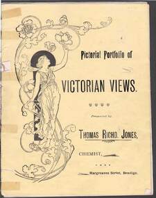
Document - PICTORIAL PORTFOLIO OF VICTORIAN VIEWS
... . Statuary in The Botanical Gardens Ballarat. View No 11. Statues... BENDIGO Parks and gardens Bendigo Chemist and Local Views. Printed ...Yellow covered nine page booklet containing 19th Century views of Bendigo and Ballarat presented by Thomas Richard Jones, Chemist of Hargreaves Street Bendigo. Art Noveau figure of woman on front cover. Inside cover features T R Jones Dispensing Chemist and Druggist printed beside man holding a horse. List of Veterinary products supplied by Jones. Farmer's requisites included Strychnine, Toxa, Phosphorus, Poisoined wheat, Bi-sulphide of Carbon. Egg preserving fluid and milk preserving powder Rennet and butter colouring along with Drenches and Cattle medicenes supplied. View No1. Moorabel Falls Ballarat. View No 2. Statues of Leda and Spring Ballarat. View No 3. A Giant Palm Bendigo. View No 4. View from St Paul's Bendigo. View No 5. Unveiling 'The first Public Statue' Bendigo P/Office in background. View No 6. Statue Presented to the City of Bendigo by Cr Harkness. [Reclining greek beside dog fighting lion] View No 7. 'On the Campaspe, near Bendigo. View No 8 The Pine Avenue, Rosalind Park. View No 9. Scenes on Lake Wendouree, Ballarat. View No 10. Statuary in The Botanical Gardens Ballarat. View No 11. Statues of Burns & Moore Ballarat. View No 12. Botanical Gardens, Ballarat. Inside back cover features list of T R Jones products. Outside back cover features advertisement for T R Jones Universal Corn Cure, and Jone's Compound Pectoral Balm.Printed by Periodicacls Publishing Co, 21 Elizabeth Street Melbourne.bendigo, parks and gardens, bendigo chemist and local views. -
 University of Melbourne, Burnley Campus Archives
Album - Black and white and sepia prints, Gardens Other Than Burnley, 1890-1920
... ) Gardener at lake edge. Snowdon Gardens: (25) View towards city... japanese garden guilfoyle snowdon gardens fern gully lake view ...Identification and information on reverse of some photographs given by Georgina Whitehead (Tel-9572 1225) who visited the Archives on 26 September, 1995 when she was writing a book on the various gardens owned and run by the Melbourne City Council-'Civilizing the city: a history of Melbourne's public gardens,' State Library of Victoria, Melbourne 1997.34 bkack and white and sepia photographs. Possibly used for Magic Lantern slides. Fitzroy Gardens: (1) Possibly, towards St Patrick's Cathedral. (2, 3) Path through avenue of trees. (4) Winter. Heavily pruned Elms. (5) Looking towards Clarendon St-eastwards. (6) Probably, lawn. (7) 2 copies, possibly Kiosk. (8) 1920's or earlier. Man sitting on bench. (9) Path through avenue of trees. (10) 2 copies. Probably-fenced originally-fences coming down 1890's on. (11) Statue at crossroad. (12) The Vase Fountain. (13) Tree trunks. (14) Tree trunks. (15) Probably, tree trunks. (16) Winding path. (17) Probably, misty winter scene. (18) Probably, summer. (19) Probably, this is the sort of garden seat used. (20) Avenue of trees, information about exposure on reverse. (21) 2 copies. Probably. Treasury Gardens: (22) Japanese Garden. (23)Japanese Garden. This area around the Lake done by Guilfoyle c.1901-1902. This photograph about this period. (24) Gardener at lake edge. Snowdon Gardens: (25) View towards city. Unidentified: (26) ?Botanic fern Gully/ Fitzroy Fern Gully. (27) Lake view. (28) Narrow path through long grass and trees. (29) Trees in winter. (30, 30a) Tree ferns. (31,32) Cordylines. (33) People on lawn. (34) Winter view of path through elms. These photographs have been scanned but have not been uploaded.georgina whitehead, fitzroy gardens, trees, elms, the vase fountain, trunks, treasury gardens, japanese garden, guilfoyle, snowdon gardens, fern gully, lake view, parks -
Ringwood and District Historical Society
Document - Handout, Ringwood Garden Club, Handout for the Beautiful Gardens of Ringwood Competition, 19th and 20th September, 1987, 1987
... St., Ringwood. 2nd. Stop: Section 3: Home Garden - Viewed...: Section 3: Home Garden - Viewed from the Street. 1st. Prize: Mr ...Handout for the Beautiful Gardens of Ringwood Competition, 19th and 20th September, 1987.Foolscap typed sheet.BEAUTIFUL GARDENS OF RINGWOOD COMPETITION. 19th. & 20th. September, 1987. The Committee of the Ringwood Garden Club would like to extend a very warm welcome to all who have joined us on today's tour. We hope you enjoy the best six of the winning gardens from the 16 entries we received. Signs in the winning gardens indicate what prizes have been awarded as well as on your programme. After the tour, we hope you will join in Afternoon Tea, kindly prepared by the ladies of our Committee. Following afternoon tea, the coaches will return to Eastland Carpark. 1st. Stop: Section 4: Individual Garden in Home Units or Flats. 1st. Prize: Mr. & Mrs.C. & B. Harris, Unit 6, 32 Wilana St., Ringwood. 2nd. Prize: Mr. & Mrs. W. & T. Wilson, Unit 5, 32 Wilana St., Ringwood. 2nd. Stop: Section 3: Home Garden - Viewed from the Street. 1st. Prize: Mr. L. Sperling, 4 Lorienne Rd., Heathmont. 3rd. Stop: Section 1: Home Garden, Street Frontage exceeding 65 ft. (20 m) 2nd. Prize: Mr. K. Clark, 42 Bronhill Rd., Ringwood East. 4th. Stop: Section 3: Home Garden - Front Only. 2nd. Prize: Mr. H. Smit, 21 Unsworth Rd., Ringwood. 5th. Stop: Section 2: Home Garden, Street Frontage not exceeding 65 ft. (20 m.) 6th. Stop: Section 1: Home Garden - Street Frontage exceeding 65 ft. (20 m) 1st Prize: Mr. B. Wheatley, 57 Oliver St., Ringwood. 7th. Stop: Afternoon Tea at the Ringwood Senior Citzens Clubrooms, Greenwood Ave., Ringwood. 8th. Stop: Eastland Carpark. We hope you have enjoyed our tour this afternoon and hope you will visit our Club's Spring Flower and Floral Art Show, which will be staged on Saturday 10th, & Sunday 11th. of October in the Ringwood Uniting Church Hall, Cnr. Station St. & Greenwood Ave., Ringwood. The show will be open on Saturday from 2.00 p.m. till 5.30 and on Sunday from 1.00 till 4.30 p.m. Entry is $1.00. Schedules and all Show information are available from the Show Secretary, Clive Manly on 873-2264. Prize Winners for the Garden Competition will receive their Certificates at the Show at the Official Opening by the Mayor of Ringwood at 3.00 p.m. on Saturday. Our show will feature displays of Cut Flowers & Shrubs, Plants in Containers, Floral Art, Cookery and Children's sections. Our Plant Stall will be operating during the days of the show and an excellent afternoon tea is available. COME TO THE SHOW AND BRING A FRIEND. OOOoooOOOoooOOO -
 Port Fairy Historical Society Museum and Archives
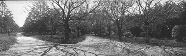
Photograph, A.C. Aberline, Gardens, Port Fairy
... Gardens, Port Fairy panoramic view. The Port Fairy... view. The Port Fairy Botanical Gardens were formed in 1856 ...Gardens, Port Fairy panoramic view. The Port Fairy Botanical Gardens were formed in 1856 making it one of the earliest gardens in Victoria. The first curator was James Prior, he was paid fifty-two pounds per annum. He was an outstanding curator having been apprenticed to the trade in England at the age of 12, his brother Edward in later years was the Curator of the Koroit Gardens. Prior retired in 1903. During the years of his curatorship Port Fairy was said to have the best gardens outside the city of Melbourne, he was constantly in touch with Baron Von Mueller and later Guilfoyle of the Royal Botanical Gardens of Melbourne. In the early years plants from all over the world were planted here with varying rates of success many of them sent by Baron Von Mueller. In the 1930’ and 40’s the gardens were still very beautiful, and the curator was Roy Manuell. The beautiful iron gates at the entrance were destroyed in the 1946 floods and were replaced in 1989 using some of the material from the original gates. From the 1950’s on the gardens went into a state of decline, much being taken up by the caravan park until in 1986, after a public meeting ‘Friends of the Gardens’ was founded when the entrance section was restored. Black and white panoramic photograph of the bare limbed trees in the botanical gardensGardens, Port Fairy- A.C.Aberline, 26 Faversham Road, Canterburygardens, winter, trees, botanical -
 Ballarat Tramway Museum
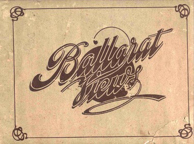
Book, Baxter & Stubbs, "Ballarat Views", 1920's
... "Ballarat Views". Sheets, other than covers have been individually...Ballarat Tramway Museum South Gardens Reserve Wendouree ...Yields information about Ballarat through pictures of the 1910-1920's various locations, institutions and street scenes, including tramways and railways.Twenty four page book within light brown covers, titled "Ballarat Views". Sheets, other than covers have been individually printed both sides, stapled within the covers. Cover - gives title, rear cover has printer details - Baxter and Stubbs. Pages 1 - Tonner Memorial , Fountain Lake Wendouree, Ballarat District Hospital, Sturt St south side at Grenville St with tram in distance and Sturt St North Side showing shops (image btm3900i2.jpg). 2 - Ballarat Street Scenes - Sturt Streets, Lydiard St with ESCo 18 in view, and Railway station with R193 in platform on passenger train. (image btm3900i3.jpg). 3 - Lake Wendouree views. 4 - Lake Wendouree, fish hatchery, Gardens and Sturt St at Dawson St (image btm3900i4.jpg). 5 - Art Gallery Ballarat 6 - Botanical Gardens 7 - Public Institution s- Benevolent asylum, Orphanage, Nazareth House, St Joseph Home, Hospital 8 & 9 - Statues, the Flight from Pompeii and others. 10 & 11 - Churches of Ballarat 12 - The Arch at The Avenue of Honour 13 - McDonald Pergola at the Gardens 14 - Zoological Gardens Ballarat 15 - Gardens aerial view and gates at the South End with tram in the distance (image btm3900i5.jpg). 16 - Some views in Ballarat East - Eureka Stockade, Ballarat East Bowling Green, Bridge St looking east and the lake at the Eureka Gardens (image btm3900i6.jpg). 17 - Snow Scene at Botanical Gardens, Begonia House 18 & 19 - Ballarat Water supply reservoirs 20 - Ballarat State Schools 21 - Ballarat East Views, includes view of track in Victoria St looking east (image btm3900i7.jpg). 22 - Views of the Water Reserves 23 - Views about the City - includes City fire station , agricultural High School, City Baths and View Point. 24 - Views at Lake Wendouree. \ Pdf copy of full book added 8/5/2019 - see btm3900i9.pdf trams, tramways, ballarat, lydiard st, sturt st, gardens, railway station, hospital, lake wendouree, wendouree parade, carlton st, esco -
 Ballarat Tramway Museum
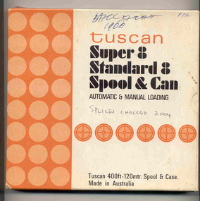
Film - Movie Film & Box, Kodak, 1960
... terminus “Trams leave here for Sebastopol, Gardens, View Point.” 4..., Gardens, View Point.” 4:34 Passengers getting off and then onto ...Yields information in movie film format of Ballarat trams in 1960, how the system operated and was used by people., Yields information in movie film format of Ballarat trams in 1960, how the system operated and was used by people.Movie film - 8mm, approx. 17.5 mins, with leader strip on a plastic reel, within a black and white plastic box, titled "Ballarat No. 1. 1960" contained with a cardboard box, 'Tuscan Super 8 and Standard 8 Spool and Can' . Has been transferred to DVD - see Reg item 4100 as Segment No. 1. Filmed and made by Ben Parle. Also transferred to DVD by Rod Cook Oct. 2015, via Roger Greenwood for use in his DVD, "The City of Ballarat Trams, Gardens & Gold" of 2016. See Reg Item 6883. Synopsis: based on time. 0:00 Starts with bogies cars crossing railway level crossing (34?, 39?) 0:30 SEC Logo 0:45 Ballarat Station sign and intro “Some City Scenes” 0:49 35 turning from Lydiard St Nth to Sturt St towards Grenville St with Commonwealth Bank in view. and then 42 returning 1:19 42 showing Mt Pleasant, turns from Sturt St into Lydiard St Nth 1:53 Tramway road works in Lydiard St Nth, near intersection with Mair St with Jelbart Road roller in use, starts with an SEC roadworks sign. 2:12 39 passing the works out bound to Lydiard St Nth. 2:46 Good view of the roller working before 35 arrives. 3:01 35 passing the works in bound with 3:29 14 crossing Lydiard St in Sturt St, towards Grenville St 3:47 Trams in City Loop 3:55 21 coming up the hill 4:04 31 entering Bridge St from Sturt St with Bucks Head Hotel in the background. 4:27 Overhead work at corner of Sturt and Lydiard, with view of the sign at the City terminus “Trams leave here for Sebastopol, Gardens, View Point.” 4:34 Passengers getting off and then onto 38, ex Lydiard St Nth at city terminus including a young lady wearing gloves and a wheeling a pram hurriedly the photographer. A number of other prams in the view as well as. The Conductor helps to unload the pram. 5:07 41 proceeding up Sturt St, appears to have just rained. 5:26 11 using the Dawson St crossover, with a motor car doing a U turn as well. 6:00 14 descending Sturt St towards the City, filmed at Dawson St. 6:11 Title “The Gardens via Drummond St North Line” 6:16 19 showing Victoria St, turning from Drummond St Nth into Sturt St. 6:28 30 inbound in Drummond St Nth, approach and trailing shots. Trailing shot ahs the hospital in the background. 6:49 31 outbound, Drummond St Nth, approach and trailing shots, trees are in autumn colours. 7:04 12, inbound Drummond St Nth, with Macarthur St in the background, stopping to pick up a lady, approach and trailing shots and then entering the Mill St crossing loop. 7:53 14 outbound in Drummond St Nth, dropping a lady passenger off and then turning into Macarthur St and then tram going away. 8:37 View of overhead junction at View Point Jtn. 8:45 View of “Cars Stop Here” sign and pole sign “To City Only” 8:55 30 inbound in Wendouree Parade, stops to pick up passenger, and then a trailing shot of tram entering Macarthur St loop 9:37 View of “Cars Stop Here”, “End of Section” and timetable boards at Haddon St. 9:50 34, pausing at Haddon St and then proceeding towards depot – approach and trailing shots, with “Warning Oncoming Trams” sign in shot. 10:27 “Warning Oncoming Trams” sign 10:32 34 crossing 12 at the Martin Ave loop 10:48 39? Wendouree Parade, near Barrett Ave, stopping and letting off passengers. 11:24 30 passing depot junction and then trailing shot of it entering Tram Sheds or Depot Loop and then proceeding towards the City. 12:11 Shot of the “Caution Beware of Trams” sign at the depot. 12:14 25 stopping at depot junction and then trailing shot of it going toward Forrest St. 12:47 12 passing Depot Junction, trailing shot. 13:07 Shot of :Electricity Supply Department, Ballarat Branch” sign at depot. 13:13 View of a destination showing “Depot” on a bogie tram 13:15 Title “Some Depot Scenes” 13:19 View of a trolley pole and then 13 leaving the depot through the gates, destination showing “View Point”. 13:54 View of trolley pole and then 32 stopping at the depot gates. 14:08 12 (Sunny view) running out onto Wendouree Parade and then a bogie tram approaching Depot Loop. 14:43 View of 42 running in with a single trucker behind in Wendouree Parade, and another single trucker running out. 15:02 Title “Some Scenes in the Gardens” 15:05 25 running through the Gardens, approach and trailing shots, near our Depot Junction. 15:55 View of “No Parking East of Loop” sign 15:59 View of overhead and then trackwork (with points removed), but overhead still in position at the Old Gardens Loop or Gardens South Loop and then 12 entering the loop from the south and then a trailing shot looking along the Parade. 16:33 View of “Cars Stop Here” and “End of Section” and then timetable boards at Gardens Loop. 16:55 View of 34 leaving the loop 17:14 Title “The End”Written labels giving title information on outside of box.trams, tramways, ballarat, sebastopol, lydiard st north, victoria st, mt pleasant, sturt st west -
 Ballarat Tramway Museum
Photograph - Black & White Photograph/s - set of 4, WHO. Robinson, c1905 of original
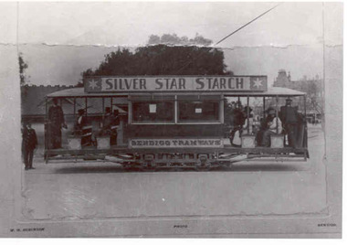
... of the photograph are buildings in Gardens area that front View St. Also... of the photograph are buildings in Gardens area that front View St. Also ...1890.1 - Black and white copy photograph of a damaged photograph of a ESCo Bendigo tramcar at Charing Cross, Bendigo, c1905. Original photograph has been damaged - mounted onto a sheet of card, with "WHO. Robinson - Photo - Bendigo" printed onto the sheet. Tram photographed side on, has not been fitted with windscreens. has a "Silver Star Starch" roof advertisement and has "Bendigo Tramways" painted onto the side of the tramcar. In the background of the photograph are buildings in Gardens area that front View St. Also the Shamrock hotel can be seen in the distance. 1890.1 - copy of same photograph but with a better reproduction and repair of the print. 1890.3 - Electronic copy of same photograph donated by Ron Hann on a CD of photographs given to him at the time of his visit in January 1963 by the Manager. Refer to email held with item 3841. Added 28/2/2010. No actual print, held on digital file only - see image 1890i3. See Reg Item 4568 for the CD. 1890.4 - Black and White print contained within the Wal Jack Bendigo and Geelong Album, see Reg Item 5003 for more details. Added 2/7/2013. On rear of 1890.2 - "Bendigo" in ink in top right hand corner and in pencil "(Similar truck to original Ballarat car No. 18"trams, tramways, bendigo, esco, view st, silver star starch -
 Ballarat Tramway Museum
Film - Movie Film & Box, Kodak, 1960 to 1971
... , 39 crossing 13 at Gardens Loop. 14.00 - view looking across..., 39 crossing 13 at Gardens Loop. 14.00 - view looking across ...Yields information in movie film format of Ballarat trams in 1960 through to 1971, how the system operated and was used by people, including special trams., Yields information in movie film format of Ballarat trams in 1960 through to 1971, how the system operated and was used by people, including special trams.Movie film - 8mm, approx. 15 mins, without leader strip on a plastic reel, within a clear plastic case - Standard 8, titled "Ballarat Trams". See Reg Item 4957 for DVD and Mini DVD. Has been transferred to DVD - see Reg item 4957 Made by Arthur Hill. Also transferred to DVD by Rod Cook Oct. 2015, via Roger Greenwood for use in his DVD, "The City of Ballarat Trams, Gardens & Gold" of 2016. See Reg Item 6883. In Arthur's letter - on file - Made between 1960 and August 1971. Synopsis: based on time. Between 1960 and 1968 0:00 Trams Ahead sign before the Victoria St terminus with 20 at terminus 0.14 - No. 20 leaving Victoria St terminus and being followed along Victoria St by car and then passengers jointing the tram at a tram stop. 00.40 - No. 12 (c1960) in bound along Lydiard St North and arriving in the Gregory St loop. 00.56 - No. 12 and 14 crossing at Gregory St. 01.20 - No. 33 and a bogie car crossing at depot loop. 01.31 - No. 18 travelling along Wendouree Parade with the Lake in the background. 01.42 - No 41 at depot junction and running into the depot No. 2 road with a short sequence of a tramway signal. 02.17 - SEC Sign at the depot gate, shot of 41 in No. 2 road, with the lights other way around, Caution beware of trams sign and a red signal. 02.31- Timetable sign at Gardens Loop 02.36 - No. 30 arriving at Loop and view of a signal with no lights showing. 02.48 - Destination roll being changed through a number of destinations. 03.26 - No. 20 arriving at Carlton St loop with the Olympic monument in the background and the red signal light going out. 03.31 - a lady standing at the front of No. 20, with an ice cream in hand, and No. 17 arriving at the Carlton St loop with a short sped up sequence and No. 20 departing from the loop, followed by No. 17 leaving the loop, heading into the city. 03.41 - No. 13 inbound from Sebastopol crossing Albert St and heading into the city. 04.12 - view of signal and contactor, the light going green and the tram passing underneath. 04.24 - No. 12 at the Sebastopol terminus and departing. 04.51 - No. 12 crossing Albert St Sebastopol. 05.16 - Following No. 12 along Albert St, with Borough Offices in background initially. 05.28 - No. 12 arriving at the Grey St loop with No. 14 arriving at the loop from the city and both trams departing. March 1971 05.58 - No. 30 being followed along Barkly St, Mt Pleasant and the pole being turned at the terminus 06.32 - No. 30 picking up a lady passenger. 06.38 - view from the front of a tram, with the drivers hand and a cigarette, view from the back of the tram, along the Mt Pleasant route and running through the loop and then turning into Main St - has the Ballarat (East) fire station in one sequence, and finally running along Main St. 07.35 - view from tram, with car turning into Bridge St. and then running into Sturt St passed the Parking Loop, and along Sturt St. 08.32 - Points at Drummond St North being changed, doors changed over and the tram running along Drummond St. North, through the Mill St loop and into Macarthur St and in Wendouree Parade, with the Lake Wendouree in view and crossing No. 12 at the Depot Loop, with crews chatting, past the depot, a lady passenger getting off the tram near Forest St., and arriving at Gardens Loop with the same lady passenger who got on in Barkly St, getting off the tram. 11.09 - view of No. 30 at Gardens Loop, departing the loop. August 1971 11.30 - R761 crossing Melton (Exford Wier) on the special train to Ballarat and then the bridge between Ballan and Gordon Stations. 12.16 - View from the front of a tram, following No. 26 along Lydiard St North, crossing at Gregory St and returning to the City. 12.39 - No. 14 and one other tram running along Albert St to Sebastopol, crossing No. 21 at Grey St and then to Sebastopol terminus, crossing Albert St and return and running along Albert St. 13.36 - No. 26, 39 crossing 13 at Gardens Loop. 14.00 - view looking across Lake Wendouree. 14.07 - 26 arriving at Victoria St, running part of Destination roll, passengers getting off with hotel in the background, trolley pole being turned and then with 39 following tram along Victoria St, crossing at the King St Loop. 15.07 - view of a trolley pole tracking through the overhead at curve 15.10 - end. Written labels giving title information on reel.trams, tramways, ballarat, sebastopol, lydiard st north, victoria st, mt pleasant, lake wendouree, depot, tram 12, tram 13, tram 14, tram 17, tram 18, tram 21, tram 26, tram 33, tram 39, tram 41 -
 Ringwood and District Historical Society
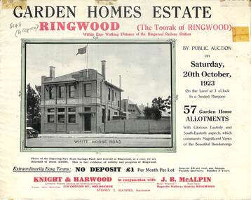
Flyer, Subdivisional Land Auction Sale Brochure, Garden Homes Estate, Ringwood, Vic. - 1923
Double sided multi-folded page advertising auction sale of residential allotments highlighting local facilities, services and layout of the estate. Includes panoramic view of Ringwood and other local photographic images.Subdivision includes Mullum Mullum Road, The Centreway, Wattle Crescent and Reserve Crescent. Agents - Knight & Harwood, 315 Collins Street, Melbourne, Phone 10615, 10616 Central, in conjunction with J.B. McAlpin, Opposite Railway Station, Ringwood. Phone Ringwood 7. -
 Ringwood and District Historical Society
Flyer, Subdivisional Land Auction Sale Brochure, Grand Central Estate, Ringwood, Vic. - 1925
Douglas Street shown in the estate plan did not eventuate, but was developed as a public reserve. Refer also to Reg. No. 5149 for 1924 auction sale of land also titled Grand View Estate situated further north in Ringwood.Double sided multi-folded page advertising public auction sale on Saturday, 31st October, 1925, of residential allotments highlighting local facilities, services and layout of the estate. Includes panoramic view of Ringwood and other local photographic images.Subdivision includes Great Ryrie Street, Heathmont Road, Douglas Street, Garden Street, and Bellevue Avenue. Agents - Knight & Harwood, 315 Collins Street, Melbourne, Phone 10615, 10616 Central, in conjunction with J.B. McAlpin, Opposite Railway Station, Ringwood. Phone Ringwood 7. -
 Bendigo Military Museum
Postcard - POSTCARD, FARNHAM, U.K, Valentine's Series, cWW1
1. Florrie is a relative living in Farnham. 2. R.H. Baron married Elsie Keast in 1921. All cards relate to R.H. Baron's visits to Farnham whilst on leave to see Florrie. Part of the 'Robert H. Baron', no.3596 and Cooper Collection. See Catalogue No. 1981P for details of Baron's service.1. Coloured scene of a ruined castle and surrounding gardens. 2. Coloured scene of a garden with building and ruins in background. 3. Coloured photograph of a red brick building with battlement. 4. Coloured street scene with buildings, horse drawn transport and pedestrians. 5. Coloured photograph of the nave of a church looking towards the alter. 6. Coloured street scene with buildings and horse drawn transport. 7. Coloured view across a street to a white walled building with horse drawn transport. 8. Coloured photograph of a church, graveyard in foreground. 9. Black and white photograph of a castle surrounded by trees. 10. Black and white photograph of a forest scene with people standing on a bridge. 11. Black and white photograph of a street scene with buildings, horse drawn transport and people. 12. Black and white photograph of the tower of a church. Graveyard in the foreground. 13. Black and white photograph of a street scene with buildings, horse drawn transport and pedestrians. Castle on the hill in background. 14. Black and white photograph of a street scene with buildings, motor cars and pedestrians. 15. Black and white photograph of a street scene with buildings, motor cars, horse drawn transport and pedestrians. 16. Black and white photograph of a wooded valley. Houses on a hill in the background. 17. Black and white photograph of an avenue of trees. 18. Black and white photograph taken in a park. Three people standing on a bridge over a stream.1. The Keep, Farnham Castle. Handwritten in black ink on back: 'This is one of the pretty places around Farnham. I was all once here with Florrie. Bob' 2. In Castle grounds, Farnham. Handwritten in black ink on back: 'Dear Elsie, these are some places that visit... when I was down at Flories place. Bob xxxxxx' 3. Farnham Castle. 4. West Street, Farnham. 5. Parish Church, Farnham. 6. Castle Street, Farnham. 7. The Church House, Farnham. 8. Parish Church, Farnham. 9. Farnham Castle. 10. Red Hill Hanger, Farnham. Handwritten in black ink on back: 'Letter to R.H. Baron's sister - no date.' 11. South Street, Farnham. Handwritten in black ink on back: 'this part of the place I spent my leave at this is where Florrie is.' 12. Farnham Parish Church. Handwritten in black ink on back: 'Letter to R.H. Baron's mother - dated 24 July 1918.' 13. Castle Street, Farnham. Handwritten in black ink on back. 'I think you will know where this is as I have told you quite a lot about Farnham, it is where Florrie is. I spent my leave here. This is Castle Street and the castle is right on the top of the hill.' 14. Borough, Farnham. Handwritten in black ink on back. ' This is the place where Florrie lives. I spent my last leave their (sic), Bob.' 15. West Street, Farnham. Handwritten in pencil on back. 'Pte R.H. Baron, 57 Battalion, Australian Imperial Forces Abroad.' 16. Lower Bourne Valley, Farnham. Handwritten in black ink on back: 'Partial letter from R.H. Baron to his sweetheart.' 17. The Avenue, Farnham. Handwritten in black ink on back: 'Partial letter from R.H. Baron to his mother.' 18. Recreation Ground, Farnham. Handwritten in black ink on back: 'Letter to Doris from R.H. Baron - no date.' robert h. baron, cooper collection, postcards, farnham uk -
 Bendigo Military Museum
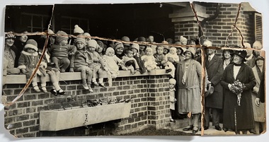
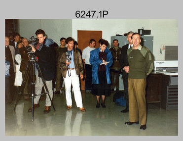
Photograph - Speedmaster Printing Press Media Announcement and Army Survey Regiment Open Day, Fortuna Villa, Bendigo, 1990
... enjoying views of the garden from Fortuna Villa’s rooftop. .28... enjoying views of the garden from Fortuna Villa’s rooftop. .28 ...The first photograph was probably taken at a media event announcing the introduction of the Heidelberg Speedmaster printing press in late 1990. LTCOL Rene van den Tol was the CO of the Army Survey Regiment from 1989 to 1991. Partly obscured behind the CO was Mr Bruce Reid, who was the newly elected federal member for Bendigo. The media event was held in Wayzgoose Hall, Lithographic Squadron’s new purpose-built building constructed to house the Speedmaster 102 printing press. The remaining 29 photographs were taken at an Army Survey Regiment Open Day at Fortuna Villa, Bendigo on the 24th of February 1990. This occasion was one of several events held to commemorate the 75th anniversary of the formation of the Royal Australian Survey Corps. Although historical tours of Fortuna occurred on a regular basis, this was the first technical open day since 1972. The Royal Australian Survey Corps recognised that an Open Day was the best way for the local community in Bendigo to gain an insight into the unit’s important role as Defence’s map production agency, its technical equipment, and its economic importance to Bendigo. It also gave them an opportunity to tour through historic Fortuna Villa. This occasion is covered in more detail in page 143 of Valerie Lovejoy’s book 'Mapmakers of Fortuna – A history of the Army Survey Regiment’ ISBN: 0-646-42120-4. Refer to Item 6291.6P for more photos of the Open Day.The first photograph was probably taken at a media event announcing the introduction of the Speedmaster printing press at Army Survey Regiment Fortuna Villa, Bendigo in late 1990. The remaining 29 photographs were taken at an Open Day on the 24th of February 1990. The colour and black & white photographs were printed on photographic paper and are part of the Army Survey Regiment’s Collection. The photographs were scanned at 300 dpi. .1) - Photo, colour, 1990. L to R: Unidentified civilian visitor/media, SSGT Ian Nichols, unidentified (x2), SGT Dale Hudson (white top), unidentified (x2), MAJ John South, MHR Mr. Bruce Reid, CO LTCOL Rene van den Tol. .2) - Photo, black & white, 1990. WO1 Gary Warnest, civilian visitors. .3) to .4) - Photo, colour, 1990. WO2 Adrian 'Charlie' Creedy, civilian visitors. .5) - Photo, colour, 1990. Civilian visitors. .6) to .7) - Photo, colour, 1990. Civilian visitors, CPL Peter Peterson. .8) - Photo, black & white, 1990. L to R: LCPL Sandy Winn, civilian visitor. .9) - Photo, colour, 1990. L to R: CPL Steve McGuiness, civilian visitors. .10) - Photo, black & white, 1990. Display of digital storage media. .11) - Photo, colour, 1990. L to R: Mr Pat Thwaites outlining utilisation of satellite imagery to civilian visitors. .12) - Photo, colour, 1990. MAJ Peter Clarke with civilian visitors. .13) - Photo, colour, 1990. Unidentified technician with civilian visitors. .14) - Photo, colour, 1990. SGT Barry Hogan with civilian visitors. .15) - Photo, colour, 1990. SPR Ian Baldwin with civilian visitors. .16) - Photo, black & white, 1990. SPR Ian Baldwin with civilian visitors. .17) - Photo, black & white, 1990. SGT Sherri (Dally) Burke with civilian visitors. .18) - Photo, colour, 1990. L to R: SPR Jeanette (Lane) Dury-Lane, CPL Diane (Thomas) Soutar with civilian visitors. .19) - Photo, colour, 1990. L to R: unidentified technician, CPL Col McInnes, LCPL Charmian McKean. .20) - Photo, black & white, 1990. CAPT Peter Parkes. .21) - Photo, black & white, 1990. L to R: LCPL Janet Murray, MAJ Bob Coote, SPR Gary Lord. .22) - Photo, black & white, 1990. LT Marty Lyons with civilian visitors. .23) - Photo, colour, 1990. LT Marty Lyons with civilian visitors. .24) - Photo, black & white, 1990. SSGT Ian Nichols, CPL Dale Hudson, Planeta printing press, with civilian visitors. .25) - Photo, colour, 1990. Cars parked in Chum Street outside entrance to Fortuna Villa. .26) - Photo, colour, 1990. Civilian visitors near Fortuna Villa’s front door viewed from back gate. .27) - Photo, colour, 1990. Civilian visitors enjoying views of the garden from Fortuna Villa’s rooftop. .28) - Photo, colour, 1990. Civilian visitors enjoying views of the garden from Fortuna Villa’s verandah and rooftop. .29) - Photo, colour, 1990. Civilian visitors enjoying BBQ cooked by CPL Paul Baker and SPR Shona Hastie outside Lithographic Squadron. .30) - Photo, colour, 1990. BBQ cooked by CPL Paul Baker outside Lithographic Squadron..1P to .30P – no annotationsroyal australian survey corps, rasvy, army survey regiment, army svy regt, fortuna, asr, printing, litho -
 Warrnambool and District Historical Society Inc.
Album, Warrnambool and District 1886 Western Hotel, 1886
This album contains a number of local coastal and seascapes including Thunder Point, views of local streets such as Liebig and Fairy streets, panorama views of the town from Manse Hill and Booval Hill and the Botanic Gardens. Buildings included are Cramond and Dickson, St Joseph’s Church, the saleyards. The book itself would have been used by patrons of the Western Hotel when J Fox was licensee, from 1880 until 1887. The hotel had been operating since 1870 when William O’Brien applied for a publican’s license for the house on the corner of Timor and Kepler Streets with five sitting rooms and eight bedrooms. The stone building was designed by Andrew Kerr and built by Williams & Co. The Western Hotel was also the booking office for Cobb and Co Coaches which operated until the railway came to town in 1890. This album has historical significance on different levels. Firstly the photographs provide a view of Warrnambool in the late 19th century. The photos are aesthetically and artistically significant. Many of the buildings in the streetscapes are still recognizable. Secondly the Western Hotel has occupied a prominent site within the CBD for nearly 150 years. It has links to Cobb & Co, an important part of early Australian transport. Large hard covered album. Dark green cover with title in red rectangle on front cover. Text in gold lettering. A variety of photographs mounted on card.Chuck Photo Ballarat on front cover. Small cutting pasted inside front cover, reads as follows,” Will and Estates. Joseph Fox, late of Grosvenor Street, Balaclava who died on 29th July by his will of 11th August 1915 left 3737pounds real estate and 2342 pounds personality to relatives. warrnambool, warrnambool history, warrnambool photographs of the past, western hotel photographs -
 Kiewa Valley Historical Society
Photos - Mt Beauty Buildings in 1973. Set of 8, 1973
The shopping centre in Mt Beauty, both buildings and streetscape, have undergone significant changes since 1973. The kindergarten has undergone extensive remodelling, The Chalet has been replaced by Svarmisk Resort and Accommodation Spa. Tawonga hospital has undergone extensive renovation and is now Mt Beauty Hospital AND Kiewa Valley House. The Workman’s Club changed name to the Country Club and has since closed down. Hospital and Kiewa Valley House now occupy what is shown as a vacant lot opposite the motel which is now called Mt Beauty Motor Inn.The houses in Mt Beauty were brought in by the State Electricity Commission of Victoria when they constructed Mt Beauty Town for their workers building the Kiewa Hydro Electric Scheme. Mt Beauty is unique began as a construction town in the late 1940's.Colour photographs of various buildings in Mt Beauty taken in 1973 1. Workman’s Club 2. View over the pondage 3. Tawonga Hospital (Mt Beauty) 4. Mt Beauty Chalet 5. Mt Beauty Kindergarten 6. The Merjei Motel 7. 8 Valley Avenue 8. Shopping Centre Handwritten in ink on the back of photos 1. Workman’s Club 1973 (after the brick makeover) From the sports oval – the high school is to the right 2. A view over the pond 1973 3. Tawonga Hospital 1973 (Mt Beauty) 4. Mount Beauty Chalet 1973 5. Kindergarten 1973 6. The Merjei Motel 1973 7. Our house at 8 Valley Ave 1973, Owner after us erected the car port, let the front hedge run amok and vanquished the vegetable garden and citrus trees Dad created. 8. Shopping Centre 1973. At the end of the street is the hospital (believe it is now Mt Beauty Bush Nursing Hotel) mt beauty, workman's club, chalet, tawonga hospital -
 Kiewa Valley Historical Society
Photographs - Demolition of the old Tawonga District General Hospital. Set of 8 colour photographs
In the early stages of the Kiewa Hydro-Electric Scheme the State Electricity Commission took over the financial and construction responsibility of the Tawonga District General Hospital building at a cost of 27,000 pounds. This included the removal and re-erection of the ex-military Bonegilla ward from Wodonga while in addition they carried out all the necessary building works that allowed the hospital to operate as a functional unit. The work was completed and handed over to the Hospital Committee of Management on September 1, 1949. Local residents raised 3,400 pounds through fund raising. The balance was met by the SEC and the Hospital and Charities Commission. The initial project was to provide for a basic temporary hospital which was later to include an Operating Theatre, Offices, Store, Mortuary and a Nurse’s Home, until the establishment of a permanent medical premises. Following the opening, 455 patients were admitted to the Tawonga District General Hospital and 254 operations were performed in the first year. The hospital relocated to Mount Beauty in the former SEC administration offices located in the town centre. Official opening of the 18 bed Tawonga District General Hospital on April 29 in 1961. The old weatherboard building was demolished around the late 1900’s to early 2000’s and replaced with a new modern brick building. Alpine Health CEO Mr Lyndon Seys oversaw the opening of the new Mount Beauty Hospital in November 2001 alongside Board of Management President Mr Andrew Randell, other board members and politicians. The Kiewa Hydro-Electric Scheme the State Electricity Commission played a pivotal part in the planning and initial funding of the Tawonga District General Hospital, with a view to providing medical support for its many workers on the Hydro scheme. Later, spouse and family members of workers were also able to access medical assistance The hospital was originally located in Tawonga away from the majority of the patients as the Hospital and Charities Board was not prepared to have it within the SEC controlled area and it was not until the gate at Tawonga South was taken down that the hospital was moved to the main centre of population at Mount Beauty.8 Colour photographs of the demolition of the original Tawonga and District Hospital situated in Mt Beauty circa 20001. No inscriptions 2. Side view of Tawonga District General Hospital, 1990’s 3. Demolition of the weatherboard hospital: Nurses station, ward and corridor 4. Demolition of the weatherboard hospital: kitchen & utility rooms 5. Demolition of the weatherboard hospital” front entrance & gardens 7. Demolition of the weatherboard hospital: Matrons House 8. No inscriptions tawonga & district general hospital; kiewa hydro electric scheme; mt beauty; -
 Kiewa Valley Historical Society
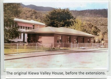
Photographs- Kiewa Valley House (before and after extensions) & Tawonga District General Hospital- Set of 6 colour photographs
... . No markings 3. No markings 4. View of the gardens between.... No markings 4. View of the gardens between the weatherboard hospital ...The establishment of Kiewa Valley House, was a significant victory for residents and senior citizens in the Kiewa Valley district. Plans were laid in the mid 1970’s and a proposal was formulated for a 12 bed unit nursing home to be attached to the Tawonga District General Hospital. The need for an aged care facility in Mount Beauty was prompted by recognition of the high ratio of senior citizens residing in the area. At the time residents had to travel to Beechworth, Wangaratta or Wodonga for care. On June 6th, 1980, an appeal to finance a 12 bed nursing wing was launched at a public meeting in Mount Beauty The Hospital and Charities Commission’s development board finally approved the application for government funds to build the 12 bed nursing home in early 1981. The official opening of the nursing home was on March 6th, 1985. Opening of the lounge extensions occurred in May, 1993 Many local residents have taken advantage of facilities at Kiewa Valley House when they became unable to manage independently in their own homes. This has meant they did not have to face the stress of leaving the area and being separated from their local family and friends. Many SEC workers and their families have been residents of Kiewa Valley House over the years.Set of 6 colour photographs of Kiewa Valley House and original Tawonga District General Hospital in Mt Beauty 1 Kiewa Valley House, before extensions, with old weatherboard hospital in background 2 & 3 Official opening of Kiewa Valley House. 4 & 5 Gardens between Kiewa Valley House and Hospital 5. Kiewa Valley lounge extension 1. The original Kiewa Valley House, before extensions 2. No markings 3. No markings 4. View of the gardens between the weatherboard hospital and Kiewa Valley House 5. Walkway between Hospital & Kiewa Valley House 6. Kiewa Valley House Lounge Room extension tawonga district hospital, kiewa valley house, mt beauty district hospital -
 Kiewa Valley Historical Society
Dress, c1950
Mrs Clare Roper wore this dress to a garden party at Buckingham Palace when she was invited there to represent the Lions Club.The Roper Family is one of the pioneering farming families of the Kiewa Valley. They built and used Ropers Hut on the High Plains. The dress worn by Clare Roper has historical significance as it represents the importance of the CWA which Claire Roper was involved with as President thus being invited to Buckingham Palace. The dress also shows the fashions of the time and indicates ladies living in the small country towns still viewed fashion as important. Since we know it was Clare Ropers dress it is well provenances, is in reasonable condition and has very good interpretive capacity. This brown shirt waister dress has an 'A' line skirt with an inverted pleat on the lower half of both the front and back. The dress has a 'Peter Pan' collar, matching belt, pockets and short sleeves. There are 3 bound button holes and buttons, gold set with pearls, only one is complete. The front top, cuffs and pockets are embroidered with cream lace. There is a press stud and hook at the neck. There is also a side zip opening in the skirt.kiewa, farming; ropers hut; lions club; clothing; clothes; dress; clare roper; high plains; buckingham palace; -
 Warrnambool and District Historical Society Inc.
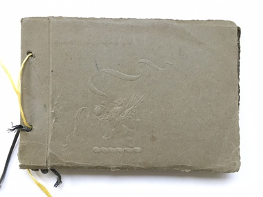
Book, Scrap Book, Circa 1930
... scenes such as view over Warrnambool, Botanic Gardens, Hopkins... such as view over Warrnambool, Botanic Gardens, Hopkins River ...This album contains photographs of many local and beach scenes such as view over Warrnambool, Botanic Gardens, Hopkins River and Bridge, Warrnambool railway station, Proudfoots, Thunder Point, Christ Church and the War Memorial. There are a couple of photographs of groups of people picnicking on the main beach. The newspaper cutting showing firemen dousing the last of the flames of the fire has onlookers including four children in the foreground. The Ozone Coffee Palace was built in 1890-1891 and burnt down February23, 1929. It was one of the largest fires in Warrnambool It was designed by Mr J McLeod. It was grand in design and decoration. The term Coffee Palace was used to describe temperance hotels which were built during the 1880’s -1890’s. They typically were multi-purpose and had a large number of rooms for ballrooms and leisure activities. Coffee palaces were aimed at families in coastal areas and inner city locations. Examples of some are The Windsor Hotel Melbourne, Ozone, Queenscliff and Kilbreda Convent in Mentone. This album has social and historical significance as it shows a collection of local scenes which is a record of familiar scenes such as the gardens, Hopkins River and beach scenes. The groups of people are unknown but the images provide a snapshot of customs and costumes of the early 1920’s.Khaki coloured soft card tied with a dark green cord which has broken and has been replaced with yellow string. There is an embossing of a lion/dragon on front cover with ribbons. 20 pages with photographs glued to most. A cutting relating to the fire at the Ozone mansions is inside the front cover.warrnambool history, early warrnambool photographs, ozone coffee palace -
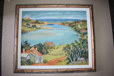 Warrnambool and District Historical Society Inc.
Framed Paintings, 1 The Frame Shop, Fairfield, Melbourne .2 Kardinia Picture Framing, Geelong, 1Warrnambool Botanical Gardens .2 Hopkins River, Warrnambool, 1953
These two works of art are by Dr Don Edgar, a sociologist, educator and author. He taught sociology at Stanford University, the University of Chicago, Monash University and La Trobe University and was the founding Director of the Australian Institute of Family Studies. In the 1950s Dr Edgar was a student at Warrnambool High School and these works of art were produced at that time. For a school project he researched the early history of the Warrnambool Art Gallery and some of its collection, dating from the 19th century. In 2019 he published a book, ‘Art For the Country’, the story of Victoria’s regional art galleries and the book includes information on the founding and the later history of the Warrnambool Art Gallery.These works of art are of interest as they were painted by Dr Don Edgar, a noted academic and author today and a former resident of Warrnambool. The two works of art also have historical interest as they depict Warrnambool scenes painted over 60 years ago. .1 An art work (oil on artboard) – the Warrnambool Botanical Gardens with bridge and reflections, a gum tree and a poplar tree, all in green and orange tonings. The wooden frame has a light varnish with gold and white trim .2 An art work (oil on artboard) – multi-coloured view of the mouth of Hopkins River with the Hopkins River bridge, Lyndoch bungalow and boathouse. The frame is wooden with a mottled varnish and a white insert edging. .1 Don Edgar 1953 Don Edgar 1953 (High School Student) .2 D.E. 53 Don Edgar 1953 (High School Student) dr don edgar, sociologist, author and educator, warrnambool art gallery, history of warrnambool -
 Eltham District Historical Society Inc
Photograph, Fay Bridge, Moor-rul Viewing Platform, Garden Hill, Kangaroo Ground, n.d
... colour prints on loan Moor-rul Viewing Platform, Garden Hill ...OPENING OF THE VIEWING PLATFORM AT KANGAROO GROUND Nillumbik Council has advised that the viewing platform at Kangaroo Ground 27km NE of Melbourne is to be opened to the public on Wednesday, March 26th 2008 (Melway 271 , G10). The function of the platform is to provide shelter adjacent to the War Memorial Tower whilst allowing all people to enjoy the stunning panoramic views. From the platform you. can see the Dandenongs, the city of Melbourne, the You Yangs, Mount Macedon, the Kinglake Ranges and the Mt Baw-Baw Ranges where the Yarra River starts. This landscape covers all the ancestral lands of the Wurundjeri and some of the wider Kulin nation land. The platform has been given the name Moor-rut, a name which described the fertile soils of the Kangaroo Ground area in contrast to the poorer (Silurian) country of its surrounds, which the Wurundjeri knew as 'Nillumbik' or less rich country. The full 360 degree view can be seen from the adjacent Tower of Remembrance which has 53 stairs. The viewing platform however can be accessed by wheelchair. Inside the viewing platform there are eight double sided interpretive panels giving the history and information regarding this special area. The viewing platform's interpretive panels set out the Aboriginal and European history of the area and also the geology and the local flora and fauna, so that the casual visitor comes away understanding more about this significant part of Victoria. The concept of the viewing platform is part of the refurbishment project for the Kangaroo Ground War Memorial Park which has taken place since 1997 with the active approval and financial assistance of the Nillumbik Shire Council. This project has been guided by an Advisory Committee with volunteer community representatives from the local Historical Societies, the Country Fire Authority, the Returned Services League and the Wurundjeri people. Other allied groups such as the Nillumbik Reconciliation Group have been called upon for their expertise. The initial idea for the viewing platform came from Dean Stewart when he was the caretaker while living at the park. He discussed this idea with local author Mick Woiwod and Harry Gilham of Eltham District Historical Society when they were planning the refurbishment of the War Memorial Park in 1996. When the committee was formalised by the Nillumbik Council in 1997, Nicholas Pelling, representing the CFA and RSL, joined the group. Dennis Ward, local architect, then volunteered to develop the concept plan for the refurbishment of the park and later drew up the plans for the viewing platform. The Kangaroo Ground War Memorial Park and its Tower of Remembrance is located on one of the highest locations in the Yarra Valley. The Tower of Remembrance is a unique war memorial constructed from local stone standing 14 metres high. It was built in the style of a Scottish watchtower reflecting the strong Scottish influence of the first European settlers of the district from the 1840s onward. The park was opened in 1921 and the Tower of Remembrance was dedicated in 1926 recognising the local people who served in the First World War. Those who served in the Second World War were recognised by plaques dedicated in 1951 and more recently those who served in Korea, Borneo, Malaya and Vietnam by plaques unveiled in 2001. Harry Gilham, Advisory Committee Convenor - Eltham District Historical Society Newsletter N0 179 March 2008fay bridge collection, garden hill, kangaroo ground, memorial park, moor-rul viewing platform -
 Eltham District Historical Society Inc
Film - Video (VHS), Jenni Mitchell, Demolition of the Shire of Eltham Offices, 1996
Poor video quality (noise and interference), edited raw footage with music and some commentary by Merv Hanna. A video documenting the demolition of the Shire of Eltham offices at 895 Main Road Eltham under the direction of the Commissioners appointed for the new Shire of Nillumbik and some of the communities activities surrounding the event. The building was demolished exactly 25 years after the southern wing housing Engineering and Planning on the upper level and the Eltham Library on the ground level was opened in celebration of the Shire of Eltham's centenary. Video has lots of distortion and noise, and sections of clips dubbed over. Immediate initial footage of Jenni Mitchell talking about asbestos claims in the Shire Offices (Sigmund Jorgensen standing behind her) advising Council did a review of the building several years previously and had been cleared of health problems. Cuts to group of people standing outside front door of offices but possibly voice dub over not related ? Then the date 27 Jul 1996 on a scene flashes on screen immediately followed by an edited clip intro of title and credits with classical music track. It then opens with Jenni Mitchell driving to the Shire Offices on Saturday 27 July 1996 at 11.00am. Footage of Main Road past Pitt Street, Alistair Knox Park then entering Shire Office driveway which is fenced off and contractor signs hanging up. Scenes at rear of building showing some internal demolition has commenced. View of the Administration wing. More clips of road driving, Alistair Knox Park, Eltham Library and visitor car park for Shire Offices. Cuts to a group of people standing in access to visitor carpark with new Eltham Library in background, one being immediate former Shire of Eltham President, John Graves. Scenes of people looking through chain link fence and security guard checking front door. John Graves being filmed that someone informed him the Shire was offering the building to the Community Health Centre for $2.3 million and that if they had been offered a price of $1.1 for what it apparently was sold for they would have snapped it up. View of truck loaded with brick rubble literally struggling to ascend the hill of Library Place to exit into Main Road. Cuts to a scene looking at Eltham War memorial Hall through the Memorial Gate, then the Shillinglaw trees and large banner sign ‘Delta Demolitions’ hanging on office façade. Views of front door, old library and bluestone wall. Scene (31 Jul 1996) filmed at night of several white crosses with “RIP Community” and “RIP Democracy”. Scene (1 August 1996) again driving along Main Road towards the Shire Offices then scenes of the offices showing substantially more demolition to exterior, groups of people standing on footpath outside watching, Delta heavy demolition machines, woman holding sign “Democracy where have you gone …”, the odd person in full protection gear and breathing apparatus hand carrying materials out to place on rubbish pile in front of people standing on footpath watching (with no protection) and then stamping on it to break it creating dust, security person in hard hat (no other protection) wandering around, many groups standing around watching, news film crew, person standing on roadside edge holding signs facing traffic stating “Pirate Planning” and “ Grant us your ears” also sign on back of parked car “Elthams High Jacks”, another sign “Community Democracy”, views of crosses in Main Road median strip “RIP Community”, groups of people on footpaths and reporters conducting interviews, footage of unknown person standing with Jenni Mitchell and Sigmund Jorgensen advising people have the right to protest, Jenni Mitchell urging people to ask questions of local MP and Council and Sigmund Jorgensen referring to the three historic Shillinglaw trees with demolition machinery operating in background, Jenni Mitchell and others installing more crosses in median strip; demolition machines operating inside and outside the building, more views of onlookers including Sigmund Jorgensen then Police approaching on footpath, workers and machinery continuing to operate, views of the old library being demolished, the former Community Services department, security personnel. Scene (2 August 1996) more heavy demolition machinery in operation smashing building up, people standing around southern wing watching, view overlooking Eltham Library of train pulling in to Eltham station. Scene (7 August 1996) more heavy demolition and people wandering around with only hard hat protection, no dust protection, comments from one operator dumping a bin of material stating “wait till there’s a Hungry Jack’s here, you’ll be laughing, fuel, videos, hamburgers. You’ll be up with the rest of the world soon, you’ll have electricity and everything here, ha ha ha ha”, more heavy machinery demolition and breaking up of materials, view of Hitachi train going by and Administration wing, view inside the front door opening of the staircase leading to upper level, person walking around operating heavy machinery with a hose spraying rubble (no protective gear other than hard hat interspersed with edit cuts of meeting of Commissioners and independent observers on panel as well as members of the community in public gallery. Nillumbik Shire CEO Barry Rochford addressing the meeting., Chief Commissioner Don Cordell directly addressing Jenni Mitchell with respect to permission to take photographs, Barry Rochford continues to address the question asked of Council about the valuation of the former Shire of Eltham Office building/site, public gallery calling out asking why was building demolished, what was the urgency. Scene (14 August 1996) views of southern wing, previous single demolition operator again mocking people filming, operators working in and around building, Shillinglaw trees and largely demolished front, heavy demolition equipment at work, piles of building rubble, hose spraying water over rubble, large trucks arriving for rubble removal and loading of truck. Scene (21 August) more of the same, building virtually down, Shillinglaw trees standing tall and alone, water spraying on rubble and wattle in bloom. Cuts to Council meeting with public onlookers. Barry Rochford walks out, Wayne Phillips addresses meeting explaining one or two people shouting, members of the community challenging Council (Commissioners) about why due process appear to have been subverted. Former Shire President Robert Marshall in public audience, cuts back to Shire office carpark entrance site and sign hung on fence in front of library “Think Again!” and people standing around observing awaiting a protest demonstration erecting a large sign on stilts stating “Shell No!”, people singing a revised version of God Save the Queen (God Save Us All), Sigmund Jorgensen in attendance, Jenni Mitchell, Sigmund Jorgenson and others address the protest crowd, followed by people mingling, music being played then people standing around the cleared site circumference all with arms linked (video very broken up with noise) then chants “Save the Gateway” and “No Shell for Eltham” and more music and singing “Put up a parking lot”. The crowd then proceeds to walk along the footpath of Main Road. Scene (15 Sep 1996) meeting at Montsalvat in Great Hall addressed by Sigmund Jorgensen discussing a recently published list of the Commissioner’s to senior Council Officers of banned Nillumbik people, others encouraging people to view proposed plans for the site and lodge objections. Specific issues regarding asbestos claims are also addressed. Harry Gilham addresses the meeting on the subject of the Eltham War Memorial and Memorial Gardens and how Council believe a roundabout in the vicinity is of greater importance. Views of various artworks on display (for auction) and music performance in the Barn Gallery. Meeting addressed by Sigmund Jorgensen discussing an appeal against Council granting a permit to Dallas Howgate to develop the site and that the Minister has called the matter in to be decided by the governing council. This is followed by an auction of paintings.Hi-Tech Ultra High Grade Video Cassette E-180 VHS dubbing of (poor quality) edited raw footage with some music from Star Wars and commentary by Merv Hannan Converted to MP4 file format 0:30:26, 2.6GBOn label " Merv's Demolition tape No. 2 Copy"video recording, 895 main road, alistair knox park, artworks, auction, barn gallery, barry rochford, community health centre, dallas howgate, delta demolitions, demolition, don cordell, eltham, eltham library, eltham shire office, eltham war memorial, eltham war memorial gate, eltham war memorial hall, great hall, harry gilham, jenni mitchell, john graves, library place, main road, memorial gardens, mervyn hannan, montsalvat, pitt street, protest, robert marshall, roundabout, shell oil, shillinglaw trees, sigmund jorgensen, sign, wayne phillips -
 Eltham District Historical Society Inc
Photograph, Glenair, 9 Minifie Avenue, Anglesea, c.1950
John Ingram, baker of Research and his wife Ada (nee Key) owned a holiday house (Glenair) at 9 Minifie Avenue, Anglesea. At some time between 1943 and 1949 they relocated permanently to Anglesea. Ada was an artist. View of rear of house from back garden.anglesea, pam thoonen (nee ingram) collection, 9 minifie avenue, glenair, house -
 Eltham District Historical Society Inc
Map (item) - Sales Brochure, Plenty Township Estate and Bryn Teg Hill's Estate, Coghill & Haughton, Melbourne, c.1924
Plenty Township Estate "The rapid growth of Greensborough and the great traffic development on the main road between Heidelberg and Eltham augurs well for Plenty Township Estate. Already a Store, Post Office and State School have been started, and the activities of the Local Progress Association will help the district forward considerably. Within walking distance of the Montmorency and Greensborough stations." Bryn Teg Hill's Estate "Better known as "The Old Sand Hill, "within walking distance of the Montmorency and Greensborough railways stations." "Some few years back Mrs Thomas subdivided portion of the Sand Hill Paddocks, and the areas sold have been settled and many converted into charming outer suburban garden homes with cultivation and orchard plots. The south-eastern slope gives the land a grand outlook over the Yarra Valley on to the Dandenoings, and the are is very picturesque and homely." "A number of the blocks contain large deposits of valuable building sand, which should prove good speculation in view of the forecast for further rapid home development along the Eltham Suburban Electric Service." Sand Hills Road (Old Eltham Road) Date estimated as c.1924 - Electricification of railway line to Eltham referenced on map occured April 1923 and Mrs Mary Thomas died August 1925. Her home Bryn Teg became part of the Heidelberg Golf Club in 1927.The establishment of Lower Plenty as a suburban growth area supported by easy commuting facilitated by the elctrification of the Eltham railway linebonds road, bridge, bryn teg hill's estate, coghill & haughton, eltham road, heidelberg golf club hotel, houses, lower plenty, lower plenty bridge, lower plenty road, main road, plenty hotel, plenty river, plenty township estate, real estate agent, sales brochure, sand hills road, the old sand hill, sand hill paddocks, woodfull road, old eltham road, bryn teg, mrs m thomas -
 Eltham District Historical Society Inc
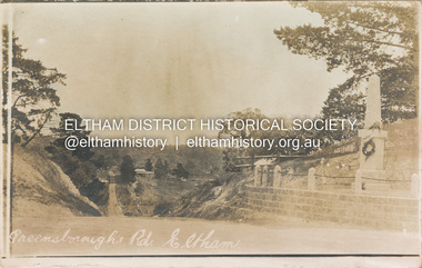
Postcard - Photograph postcard, Greensborough Road, Eltham, c.1925
Rare postcard showing view looking down Bridge Street with the Eltham Obelisk in situ in its original location. The Obelisk War Memorial was unveiled 3 August 1919. Subsequent to the unveiling provision was made of a stone retaining wall topped with a chain link and granite stone boundary. Along with the use of the name Obelisk Corner, the Bridge Street bridge was also known as Obelisk Bridge. The Obelisk was relocated to the fornt garden of the Eltham RSL sub-branch in the mid 1950s as a result of road widening and corner improvements. The Bridge Street Bridge was replaced with a new concrete bridge in 1956-1957.Digital file only Postcards scanned from the collection of Michael Aitken on loan to EDHS, 2 Sep. 2022michael aitken collection, eltham, postcards, bridge street, bridge street bridge, obelisk, obelisk corner, eltham cenotaph, eltham obelisk, war memorial, main road -
 Eltham District Historical Society Inc
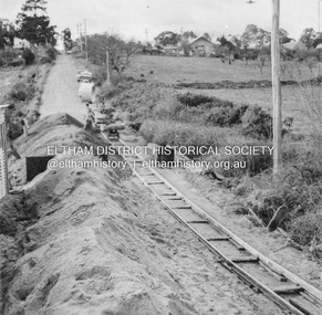
Album - Photograph, J.A. McDonald, Eltham-Greensborough Road, July 1956
Diamond Creek Bridge (Bridge Street Bridge) General view looking to Main Road View looking east up Bridge Street to Main Road prior to widening. The Eltham Obelisk is located at the top of the hill on the left but was relocated to the Eltham RSL front garden as a reesult of road widening works and improvements to the intersection. On the immediate right is the present-day Eltham Rugby Union ovalRecord of various Shire of Eltham infrastructure works undertaken during the period of 1952-1962 involving bridge and road reconstruction projects, sometimes with Eltham Shire Council Project Reference numbers quoted. It was during this period that a number of significant improvements were made to roads and new bridges constructed within the shire that remain in place as of present day (2022). In many situations, the photos provide a tangible visible record of infrastructure that existed throughout the early days of the Shire. The album was put together by or under the direction of the Shire Engineer, J.A. McDonald.infrastructure, road construction, shire of eltham, bridge construction, bridge street bridge, eltham, eltham-greensborough road, 1956-07