Showing 982 items matching "homestead."
-
 Stawell Historical Society Inc
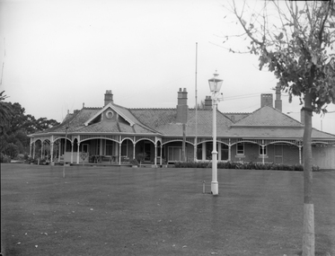
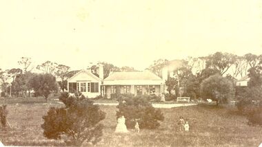
Photograph, “Swinton” Homestead in Glenorchy with alight pole and flagpole on the front lawn, 1913 approx
Black and white photo of “Swinton” Homestead Glenorchy with light pole and flagpole on front lawn. Swinton was a family name of John Carfrae whose father was Thomas Swinton Carfrae of Edinburgh. When John Carfrae came to Ledcourt in 1848 he divided it into three runs, Ledcourt - Swinton & Newington. Alexander Grey came to Swinton in 1881. The Grey Family still live at Swinton. After severe floods in 1909 the original homestead was destroyed. This home picture was built in 1911 on a site on higher grounds.B/W. Photograph: of a substantial house with five chimneys and verandah and Flagpole, in the mid distance is a light pole with a gas light, in the foreground is a tree. This photograph is a copy of a negative owned by the society. Paid with a grant 1991. this photograph is of the home at SWINTON Glenorchy. glenorchy -
 Sunbury Family History and Heritage Society Inc.
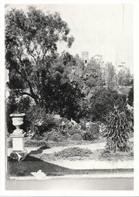
Photograph, 'Glenara' Homestead
The garden in the image was taken in the grounds of Glenara Homestead at Bulla, which was owned by Alister Clark of rose breeding fame. Refer to entry P0951 for the information relevant to the Clark family.A non-digital black and white photograph with a cream border of a large garden. A tower is seen in the distance and a pottery urn on a pedestal is to the LHS at the meeting of a pathway. -
 Stawell Historical Society Inc
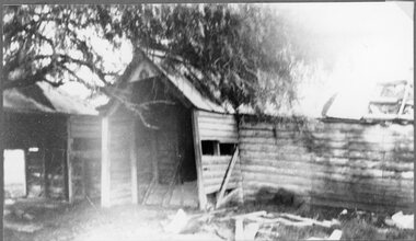
Photograph, "Ashen" Homestead Remnants in Murtoa after a Storm c1920’s
Dugald McPherson's Ashen's Homestead (Remnants) c1920’s Ashen's south of Murtoa was one of the area's original squatting runs. This photo taken in the 1920's shows the homestead after a violent storm had been through the area. In 1853, the country around Ashen's was covered by timber, she-oaks, bull-oaks, light gum and box thickets of ti-tree and clumps of pine and wattles. The vegetation was so thick outside the horse paddock it was difficult to move in any direction. It was said McPherson and two others fought over the land.Back entrance to Ashen's Station.stawell -
 Stawell Historical Society Inc
Photograph, “Overdale” Homestead in Concongella
“Overdale” Holden Homestead Concongella. James Holden settled on "Overdale" in the late 1860's. The Holden Family still live at "Overdale" The Holden Family have served on the Stawell Shire Council for over 100 years.Black and White enlarged photograph of house in file and small original photo in album. Building has prominent stone wall and trees around the house which has an inner timber and wire fence. Overdale sign on the stone wall.stawell -
 Stawell Historical Society Inc
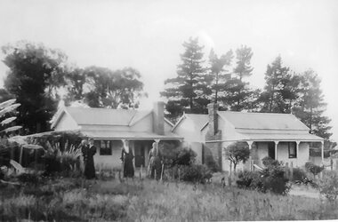
Photograph, "Mont Glen" Homestead - Watta Wella
Original "Mont Glen" homestead - Watta Wella. Bulit by Joh Blades Hall Senior - Located 300 metres behind "Lynleigh" (Home of grandson Collin Hall) - Later was the residence of his son Jahn Blades Hall Jnr.B/W Photo. Weathe board buildings , 2 chimneys, Pine trees behind. 3 Women in long dresses, 1 holding a child -
 Cheese World Museum
Photograph, Tooram Park homestead c1915, early 20th century
The Percy Uebergang family lived at Tooram Park, Allansford from 1912 until 1992. Percy and Myrtle Uebergang's children were twins, Ray and Joyce born in 1926 who lived at Tooram Park until their deaths, Ray in 1986 and Joyce in 1992. Neither Ray nor Joyce married and following the death of her brother Joyce set up the Ray and Joyce Uebergang Foundation which supports the local community. This photograph is part of the collection of items given into the care of the Cheese World Museum. The Uebergang family purchased Tooram Park in 1912. It was part of the original Tooram run which was taken up in 1839/40 by John McMahon Allan. Allan held the property until 1860 after which it passed through several owners including John Orlebar, Thomas McLeod Palmer, Owen family. Tooram was famous for the cheese from its large dairy herd. The herd was hand-milked. Palmer employed Indian labour to undertake this task. In 1883 Palmer was charged with the manslaughter of an Indian worker but was acquitted. This case was extensively reported in the Warrnambool Standard. The Standard also featured a number of articles about Tooram [22 June 1882, 17 March 1883 to 15 May 1993, 30 October 1886, 22 October 1897, 11 May 1926, 8 June 1931]. The property remained in the Uebergang family until after Joyce's death in 1992. Tooram is significant as it was one of the earliest runs taken up in the Warrnambool area. It was divided up following its sale in 1897. Tooram cheese was renowned. This photograph is significant as it shows Tooram Park homestead in its earlier days with the prolific timber decoration which was later removed.Black & white photograph on a cardboard mount showing Tooram Park homestead. The house has a white picket fence. A drain is in the foreground and is serviced by a stone culvert is in the right foreground. Two cars are parked in front of the house. The house walls are painted a dark colour. The verandah roof is striped dark and white. The timber decoration on the verandah, barge board and gable is white.allansford, tooram, tooram park, uebergang, john orlebar, john mcmahon allan, thomas mcleod palmer, owen family, indian labour, court cases, dairying, dairying, warrnambool standard -
 Wodonga & District Historical Society Inc
Album - Ringer's River by Des Martin - Plate 14 - O'Day visits the O'Hara's homestead
Daylight O'Day swims the river alone and, instead of going straight back to Gooloora, rides up-river a little to call at O'Hara's slab homestead where he is given a very warm welcome by young Erin O'Hara. Ellen Tenteye as Erin O'Hara.The album and images are significant because they document literature written by a prominent member of the Wodonga community. The presentation of this precis was supported by several significant district families and individuals.Ringer's River Album Coloured photo Plate 14des martin, many a mile, ringer's river, northeast victoria stories -
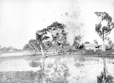
 Lake Bolac & District Historical Society
Black and white photograph, "Lake Boloke" homestead and the dry shore-line of Lake Bolac, circa 1855
A very early view of the first blue-stone homestead and out-buildings at "Lake Boloke" station, established by Robert Patterson, believed taken in the early 1850's. The row of River red-gums indicates the shoreline of Lake Bolac which seems to be at least partially dry.lake bolac, lake boloke station, patterson -
 Stawell Historical Society Inc
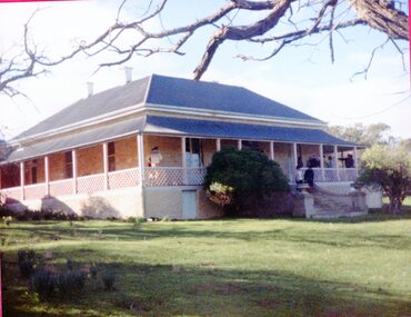
Photograph, Leadcourt Homestead
Leadcourt Homestead was built about 1868 by Mr. John Holt. Stone was transported from Mr Difficult. The Governor was entertained here in 1868 when he opened the Stawell Railway Station. One Sectionof the gable wing contained a bath large enough to swim in. 7115, 7115.1 Exterior of Ledcourt. 7115.2 Mrs Ethel Cooper facing lleft at the front entrance. 7119.3 View showing the office and rear of the homestead. 7114.4 Toilet block two section each able to seat two adults and one child at a time. 7115.5 Office Block. 7115.6: John Holt drowned in this dam in November 1876 in 10 feet of water. 7115.7 view of the grindstone ath the bace of an Oak tree. the bell was used to to call people to eat meals.A Group of 9 Colour Photos showing Leadcourt Homested. -
 Bacchus Marsh & District Historical Society
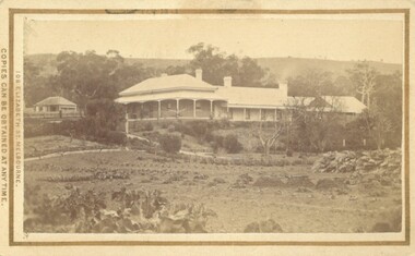
Photograph, Glenmore Homestead 1883
This homestead was built by Charles Griffith on a 55,000 acre Run. It replaced an earlier dwelling which was a slab hut with a bark roof. Charles Griffith, an Irish barrister, with his friend, James Moore, settled on Glenmore Station in the Parwan Valley in 1840. Their partnership lasted until 1848. In 1846, whilst in Ireland, Griffith married Miss Jane Catherine Magee, then returned to Glenmore and later took his nephew, Molesworth Richard Greene, into partnership, which arrangement proved to be long and prosperous. In 1857, they bought runs at Mount Hope and Mount Pyramid, which they kept until the days of free selection. Griffith led an active and successful public life.He was a member of the new Victorian Legislative Council in 1851, and was later an elected representative of the Legislative Assembly 1853-1859. He occupied many important public positions, including that of magistrate for Bacchus Marsh. Griffith was a devout Anglican and hosted Bishop Charles Perry at his station near Bacchus Marsh in 1849. He died in 1863 at his home in South Yarra.Small sepia unframed photograph on card with gold border framing photograph. Housed in the album, 'Photographs of Bacchus Marsh and District in 1883 by Stevenson and McNicoll'. The photograph shows a view of an extensive single-storey homestead consisting of three adjoining buildings, with a further building on the left of the main property. The series of three buildings is built in an elevated position, with pathways leading through a garden. At the front there is a vegetable garden which seems to be still in a state of development. The main house, possibly of brick, is set at an angle to the other two in this complex. It has a hip roof with a concave verandah on two sides with arched barge boards and simple unadorned pillars. There appears to be a hammock slung between two pillars. Two chimneys can be seen on this dwelling.The adjoining building is of a simpler design, with a lower roof line and a verandah running along the front. Two chimneys can be seen, one emitting smoke. This middle building may be a kitchen and rooms for day-to-day use. The third building is also of a simpler design, with a gable above a verandah. The purpose of this building is less clear. The different styles of construction suggest that these buildings were built separately at different times for different purposes. To the left of the main group of buildings is another cottage, smaller and of a simpler design. A fence runs along the front, clearly separating this building from the others, suggesting it may have been the dwelling of an overseer.On the front: Stevenson & McNicoll. Photo. 108 Elizabeth St. Melbourne. COPIES CAN BE OBTAINED AT ANY TIME. On the back: LIGHT & TRUTH inscribed on a banner surmounted by a representation of the rising sun. Copies of this Portrait can be had at any time by sending the Name and Post Office Money Order or Stamps for the amount of order to STEVENSON & McNICOLL LATE BENSON & STEVENSON, Photographers. 108 Elizabeth Street, MELBOURNE. stevenson and mcnicoll 1883 photographs of bacchus marsh and district, farms bacchus marsh, charles james griffith 1808-1863, glenmore station -
 Mt Dandenong & District Historical Society Inc.
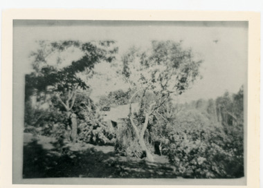
Photograph, Harmony Vale Homestead
This photograph of 'Harmony Vale' homestead was taken by Daisy Rowse c1917. It is a copy of the original. 'Harmony Vale' was the home built c1860 by early settler Jabez Richardson and his wife Sarah Ann. Jabez Richardson arrived in 1855 with the Child and Jeeves families. The building and barn stood until 1933. The name Harmony Vale was given to the early settlement.Black and white photograph with the roof of a house in centre surrounded by trees. harmony vale, daisy rowse, jabez richardson, richardson, homestead -
 Greensborough Historical Society
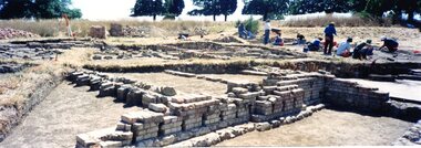
Photograph - Photograph Collection, Jan Macdonald, Viewbank Homestead archaeological excavation 1999, 1999
In 1999, an archaeological dig was undertaken at the Viewbank Homestead site in Viewbank. This set of photographs was taken at the dig site in 1999. The house was built c1840 by James Williamson; it was later purchased by George Gear as a wedding gift to his daughter on her marriage to Dr Robert Martin. It became a grand mansion in the late 1800s but by the 1920s, it was stripped bare of materials and demolished in the 1920s. The archaeological dig was and insight into early life in the Viewbank HomesteadSet of 8 panoramic photos of archaeological dig and flyer for dig.viewbank homestead, banyule road viewbank, viewbank, archaeological digs -
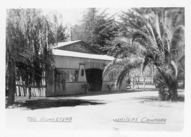 Lakes Entrance Historical Society
Postcard - Whiters Camp Park, Bulmer H D, 1945c
One of a set of eight small format postcardsBlack and white small format postcard of the Homestead at Whiters Camp Park. A fibro cement sheet clad residence of the proprietors family, palm tree at the right hand side. Lakes Entrance VictoriaThe Homestead, Whiters Camp Parkresort, recreation, tourism -
 Eltham District Historical Society Inc
Photograph, Fay Bridge, Rosehill Homestead, EDHS Heritage Excursion, 6 July 2019
July Excursion July 6, 2019 - Exploring Lower Plenty The predominant feature of this walk in the Bonds Road area, Lower Plenty is the large number of magnificent old River Red Gums that line the route. These trees are of the spreading woodland form of this species indicating that they must have been originally growing in a reasonably open setting. The walk also includes parts of the historic Cleveland Estate and the homestead “Rosehill” established by pioneer farmer Henry Stooke. This area was the site of the first recorded European settlement in what was to become the Shire of Eltham when the Willis brothers arrived in the late 1830s. From the southern part of Cleveland Avenue there are extensive views across and along the Yarra Valley. An article on the history of this area was contained in Newsletter edition 201, November 2011. The walk will start at the at the corner of Bonds and Stawell Roads, Lower Plenty - EDHS Newsletter No. 246 June 2019fay bridge collection, 2019-07-06, blackburn bricks, eltham district historical society, heritage excursion, rosehill homestead, lower plenty -
 Stawell Historical Society Inc
Photograph, "Schoolers" Homestead at Lake Lonsdale 1866
Schoolers Homestead Lake Lonsdale. Part of a collection of Photographs by Mr. O.G. Armstrong as commissioned by the Shire of Stawell for the Inter-colonial and Paris Exhibition in Melbourne in 1866. Similar Photo Scoullar station Rosehill Cat No 3888 G.F. Scoullar originally from Canada, according to W.G. Sharply in his 1930 Stawell Borough History, was a member of the Stawell Shire Council 1870-1888 and president 1875-1876. Maynard Ord in Stawell Past and Present says G.F. Scoullar, M. Brinkman and one other, took up small pieces of land fronting Lake Lonsdale. The owners of the Squatting Run, presumably Ledcourt, charged them with illegal occupation. They were heavily fined at Pleasant Creek Court, or in default gaol. As they could not afford the fine, some friends raise the money. Note re the spelling of ‘Schooler’. Variations in local records are ‘Schoullar’ and ‘Scoullar’. stawell education -
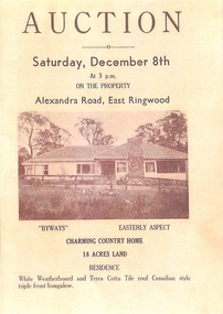 Ringwood and District Historical Society
Memorabilia - History Timeline, Byways Homestead, Coolooli Estate, Ringwood East, 1878-2008
Development of Coolooli Estate with property titles and leaflets for the sale of "Byways" homestead, 4 Byways Drive, Ringwood East. Also the house at 9 Walhalla Drive, Ringwood East. Correspondence between David Best and Richard Carter re the estate. Coolooli subdivision includes lots fronting Isabel Avenue, Byways Drive, Coolooli Court, Walhalla Drive and Cleland Street. Property Titleholders include: George Blood William Chelman Thurgood Frederick Deine Laurie Arthur Wigley Charles Patterson Mary Aphra Patterson John Douse Langley August DiGilio Kenneth Ross Landy Mervyn MacPherson Brewer Richard Blennenhassett Best Jessie May Cleland John Brian Little Robert William Campbell Lynette Marie Campbell Lorraine Ruby Campbell David Charles Nicholls Barbara Janette Nicholls Ian Finlay Packer Nellie Packer -
 Buninyong & District Historical Society
Photograph - Mount Buninyong Homestead front view, View showing part of the homestead of Mount Buninyong Homestead taken by an unknown photographer in 1991, 1991
House built by the Sott Family in 1884.Good condition, showing clear details of the buildingNonehistoric homestead, scott family, scotsburn. -
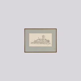 Wangaratta Art Gallery
Work on paper, Maurice Cantlon, Bontharambo, 1965
Cantlon is widely known for his illustrative paintings of Victorian historic homes, and he wrote and illustrated Homesteads of Victoria 1836-1900 published by Georgian House in 1967. Bontharambo is a homestead located in Wangaratta and was built in 1857-9. This homestead plays a prominent role in the history of Wangaratta and the pastoral history of Victoria. Rural City of Wangaratta Collection. Purchased with funds from the Wangaratta Art Council.An black ink sketch of the Bontharambo homestead on white paper.Obverse: Cantlon 65/ (bottom right)wangaratta art gallery, maurice cantlon, ink drawing, bontharambo, homestead -
 Phillip Island and District Historical Society Inc.
Photograph, Churchill Island cannon, 1973
This cannon was always called the Shenandoah cannon as it was believed to be from the Confederate warship, Shenandoah. However recent research has shown this was not true. In 1981 the American Civil War Round Table of Australia claimed the cannon was not government issue.It was older than the Shenandoah warship.It is possibly a 4 lb that was sent from Sydney in 1826 when Western Port was settled and had been left behind.Historical3 small coloured photographs mounted on cardboard of Churchill Island homestead, 2 men standing beside the cannon and the cannon.Churchill Island homestead, Shenandoah cannon, S.J.McFee, F. Jansson, Shenandoah cannon. 1973churchill island, churchill island - homestead, cannon, stan mcfee, frank jansson -
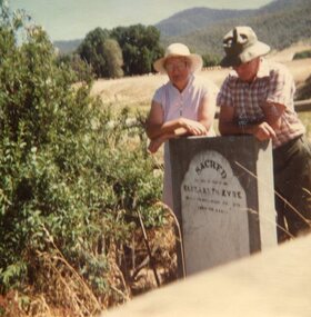 Kiewa Valley Historical Society
Photograph x 2 of pioneer gravesites, 11th January, 1985
Pictorial record of the graves of early pioneers Mrs Elizabeth Eyre who died in 1879 located at Tawonga Homestead and Mary Hollands , located at Mullagong in TawongaRecord of early history of Kiewa Valley pioneers Gwen Hobbs and Rob Hollands are descendants of pioneer farmers. Hobbs and Hollands families have lived and worked in the Kiewa Valley for many years.1. Colour photograph of 2 Kiewa Valley residents visiting gravesites of pioneer Elizabeth Eyre who died in 1879. Grave located at Tawonga Homestead. 2. Colour photograph of Kiewa Valley residents visiting the gravesite of Mrs Mary Hollands, pioneer of the area. Gravesite located at Mullagong property in Tawonga.1. Handwritten in ink on back of photograph: Gwen Hobbs and Rob Hollands - Tawonga Homestead grave 2. Handwritten in ink on back of photograph: Gwen Hobbs and Barbara, Rob and Margaret Hollands at Mullagong graveselisabeth eyre, mary hollonds, tawonga, graves -
 Tatura Irrigation & Wartime Camps Museum
Book, Merriang, 1985
Written by Hilde Knorr about her experience of buying, renovating and living in Merriang homesteadSoft cover book. Grey and white picture of a homestead and surrounds on front cover. A short history of the homestead and a picture depicting a balastrade on the back coverHilde Knorrmerriang, knorr h, camp 1, tatura, ww2, books, history, local -
Whitehorse Historical Society Inc.
Article, Blackburn bellbird heritage
Advertisement in Nunawading Gazette.Advertisement in Nunawading Gazette of an original Blackburn homestead 'Koolangara' for sale.Advertisement in Nunawading Gazette. koolangara, blackburn, real estate -
 Phillip Island and District Historical Society Inc.
Photograph, 1978/9
The Homestead was probably built about 1872 when Samuel Amess became the owner of Churchill Island.coloured photograph showing the Homestead on Churchill Island.local history, photographs, buildings - historical, rural industry, coloured photograph, john cook, churchill island -
 Wangaratta Art Gallery
Work on paper, Maurice Cantlon, Fairfield, Rutherglen, 1966
Cantlon is widely known for his illustrative paintings of Victorian historic homes, and he wrote and illustrated Homesteads of Victoria 1836-1900 published by Georgian House in 1967. Fairfield, Rutherglen is located in the North East region of Victoria and is a historic homestead that was built in 1889 and plays a prominent role in the history of the region. Rural City of Wangaratta Collection. Purchased with funds from the Wangaratta Art Council.An black ink sketch of the Fairfield homestead on white paperObverse: Cantlon 66/ (bottom right)wangaratta art gallery, maurice cantlon, ink drawing, homestead, fairfields, rutherglen -
 Federation University Historical Collection
Photograph - Photograph - Colour, Banongill Station Skipton, 1987
Photo possibly taken on a family visit to an open day at the Station in 1987. The Banongill Station homestead was established in 1853, originally an outpost of Borriyalook Station, which was owned by pastoralist and philanthropist Francis Ormond, founder of Ormond College. Part of Borriyalook was separated from the home station in the 1850s and renamed Banongill.Coloured photograph.1 Verso-Skipton1987 Banongil Homestead and lawns .2 Rare palm trees in lawn at Banongil Homestead .3 Paths Lawn and garden of Banongil Homestead Skipton -
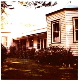
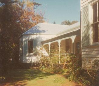
 Eltham District Historical Society Inc
Photograph - Digital Photograph, Jim Connor, Edendale Farm Homestead, 11 December 2014
Edendale Farm is Nillumbik Shire Council's environment centre situated in Gastons Road, Eltham between the railway and the Diamond Creek. The homestead on the property was built in 1896 and is of historical significance, being the subject of a Heritage Overlay under the Nillumbik Planning Scheme. The Edendale property was originally part of an extensive land purchase in 1852 from the Crown by pioneer Eltham farmer Henry Stooke. He initially purchased 51 acres and later expanded his holdings by purchasing another three adjacent Crown allotments extending northerly from Josiah Holloway's Little Eltham subdivision. Despite clearing the land, Stooke did not build on this property, choosing to live on his property "Rosehill" at Lower Plenty. In 1896 Thomas Cool, Club Manager of the Victoria Coffee Palace in Melbourne purchased 7 acres of the original Stooke land and built the house now known as Edendale. Cool did not farm the land, instead using it as a gentleman’s residence, retiring to Eltham at weekends. In 1918 he purchased an additional 7 acres but in 1919 he sold the property. Later owners included J.W. Cox, the Gaston family and D. Mummery. In the 1980s the Eltham Shire Council purchased the site for use as a Council depot, but this use did not proceed. Subsequently, it was used as the Council pound. The Edendale Farm Pet Education and Retention Centre was established in the summer of 1988/1989 and was set up to replace the existing dog kennels with a high standard pet retention centre. The design style of the building was established to compliment the features of the existing house. It was equipped with 10 retention pens, a veterinary room and a pet education area where school children and other interested parties learnt about pet care procedures. It was later developed into a community farm and was run by an advisory committee and in 2000 it became an Environment Centre. In early 2006 an advisory committee was established for the development of a master plan for future development at Edendale Farm. The committee included Russell Yeoman, a former long-time shire planner and founding member of the Eltham District Historical Society. At the time of filming the Master Plan and future for Edendale was about continuing to develop Edendale as a centre of environment learning and looking at expanding displays and school program, running a lot more of life-long learning and workshops around sustainable living.jim connor collection, edendale community farm, edendale farm, eltham, gastons road -
 Phillip Island and District Historical Society Inc.
Photograph, Bryant West
One of a collection of over 400 photographs in an album commenced in 1960 and presented to the Phillip Island & Westernport Historical Society by the Shire of Phillip IslandPhotograph of McFee Homestead as Rhyll Post Office. Wattle and Daub building on right, beneath large Gum treeNotice attached to Homestead building reading "Rhyll V R Post Office" Crown symbol between V & R.local history, photography, photographs, rhyll post office, black & white photograph, mcfee homestead, wattle & daub building, john jenner, bryant west -
 Bendigo Historical Society Inc.
Slide - Adelaide Vale Homestead Fosterville
Adelaide Vale Homestead was begun in 1853 by John Harvey and was later occupied by Edward and Andrew O'Keefe. The building comprises a series of single storey stone buildings arranged behind a simple composed, verandah facade with a centrally located doorway flanked by windows. A central corridor leads from this doorway to a transverse corridor which was probably once an open breezeway. A free- standing octagonal pavilion is located close to the house. This is an interesting homestead dating from early times and constructed of local stone. The front facade is typically composed and the plan reflects the continuous growth of the property throughout the nineteenth century. The octagonal pavillion is a significant and unusual feature. The homestead is picturesquely sited and overlooks the Campaspe River valley, the Burke and Wills expedition camped nearby on their ill-fated expedition north. The old cheese factory is the sole survivor of the once extensive out-buildings. Some of the nineteenth century buildings have been demolished and there have been some later additions and alterations, notably an extensive side wing added in the 1920's. [In Butcher & Flanders, Bendigo Historic Buildings, 1987, the date of the house is given as 1868. Presumably this house replaced an older one on the property.]Adelaide Vale Homestead Fostervillehistory, bendigo, national trust collection bendigo, adelaide vale homestead -
 Port Fairy Historical Society Museum and Archives
Photograph
Leura Station homestead owned by Horace Flowers EsqBlack and white photograph of Leura station homestead with several women and children standing outsideleura, h flowers esq, house, station, farm, princes highway, building, horace -
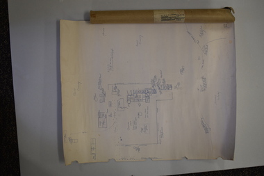 Warrnambool and District Historical Society Inc.
Document (Sketch Plan of Dunmore), Stan Baulch, 1972
This card has a sketch map showing the properties surrounding Dunmore on one side and a detailed sketch plan of Dunmore homestead in the early 1970s on the other side. The plan of Dunmore homestead shows interesting features such as the brick oven for bread making, the croquet lawn, the site of the aboriginal mia mias, the Turkish baths and the fowl house used later as a poison house. Francis and Ann Baulch were pioneer settlers in the Kirkstall area and their son Samuel worked at Dunmore in the Macarthur area before purchasing in the early 1870s the property he named Rose Park. In the 1890s he acquired property in the Dunmore estate and his son Stan Baulch gained a section of the Dunmore property after his father’s death. Stan Baulch named this Dunmore section, Rose Park, a property to the west of his father’s original Rose Park property. Stan Baulch was a long time member of the Warrnambool & District Historical Society and he contributed many local history articles and donated many local artefacts to the Society.This sketch plan is of interest as it tells us what the historic homestead of Dunmore in Western Victoria was like in the early 1970s. It will be useful for research. This is a sheet of white lightweight cardboard with a pencilled sketch on one side and a blue ink sketch plan of a house on the other side. The edges of the card have some torn sections. The card is enclosed in an oval cardboard cylinder (recycled and torn at the ends). Both the card and the cover have handwritten titles in ink. Dunmore Homestead & History by S. Baulch Dunmore Homestead drawn by Stan Baulch c.1972 dunmore property, western victoria, baulch family