Showing 353 items matching "land settlement"
-
 Glen Eira Historical Society
Plan - Nettalie
... Land subdivisions Land use Settlements Roads and streets Hotels ...An A4 photocopy of the 'Plan of the Caulfield Road District' dated 1867. This plan shows the location of the properties owned by A Shaw and Blundell on Balaclava and Orrong Roads where Nettalie is situated. The plan includes all the landowners listed where their property was, the street names and other landmarks of 1867 including railways, hotels and reserves.caulfield, caulfield north, elsternwick, st kilda east, parish of prahran, parish of moorabbin, caulfield road district, melbourne and brighton railway, rosstown railway, elsternwick railway station, caulfield railway station, rosstown railway station, murrumbeena railway station, baptist church, paddy’s swamp reserve, cemetery reserve, leman swamp reserve, caulfield racecourse reserve, brighton cemetery, the vine caulfield hotel, the tam o’shanter hotel, melbourne hunt hotel, royal hotel, hotham street, horne street, nepean highway, north road, orrong road, dandenong road, princes highway, kooyong road, alma road, inkerman road, balaclava road, glen eira road, glen huntly road, hawthorn road, cemetery road, bambra road, redan road, kambrook road, neerim road, booran road, racecourse road, grange road, koornang road, murrumbeena road, crosbie road, kangaroo road, poath road, ford w, lempriere, cople j, riddell j c, manifold j, testar t, billing r h, semple, blundell, shaw a, butchart g, stephen j w, stephen g sir, hart j, duncan g, blackie r, stephen f, mccombie t, woollaston h, higgins j, lloyd j c, daish j, mcleod j, hughes d, wilson a, jamieson g, webb g h, renwick s, pennington h, dunn j, kirkpatrick w, ricketson w, toad a, sayce j, watts t, widgery, store, guess j, anketell j, clack j, sissen w, clayton g, dickson d, bevan j, hart t, anderson j, hart mrs, webb h, masters s, waghorn j, hemming c, hiam c, farquhar w, newing t, payne t, cooper r, snipe s, chambers j, forster w, summers r, harriman b, warrick, o’connell, long j, peck r, cochrane c, murray ross w, evans c, kennedy j, maclean n, forster, lyall w, dean j, newton h, looker w, baker c, johnston, crosbie j, kerr, jones, parr, nelson c, montgomery l, parsons w, james j c, sibon c, smith sydney w, plans, maps, land subdivisions, land use, settlements, roads and streets, hotels, churches, police stations, post offices, land surveys, railway stations, railways, schoolhouses, commerce, clergy residences, official buildings, local government, road districts -
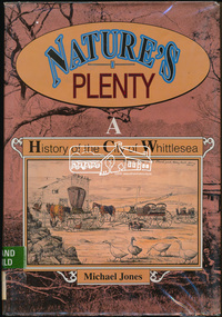 Eltham District Historical Society Inc
Book, Michael Jones, Nature's plenty : a history of the City of Whittlesea, 1992
This book explores Whittlesea's history from early 1830's to 1991. Environment of the Aboriginal people about the the time of European settlement. Possible use of a 'swamp management system' now buried under Yan Yean reservoir. Smallpox epidemics among Aboriginal people prior to settlement - probably from the activity of nearby European sealers. Estimations of Aboriginal populations. Scattered references throughout. Subjects Health - Infectious diseases - Smallpox. Settlement and contacts - Colonisation - 1788-1850. Settlement and contacts - Colonisation - 1851- Environment - Land management. Demography. Woiwurrung / Wurundjeri / Woiwurung people (S36) (Vic SJ55-05) Yan Yean (Vic SJ55-05) Eden Park (Vic SJ55-05) Whittlesea (Vic SJ55-05) Diamond Creek (Vic SJ55-05) Kingslake (Vic SJ55-05) Whittlesea (Vic.) -- History.xvi, 319 p., [16] p. of plates : ill. (some col.), maps (some col.), ports. ; 28 cm. the plenty, farming, settlement, gold rush, plenty river, donnybrook, germantown, separation, thomastown, whittlesea, epping, woodstock, city of whittlesea, railway, yan yean, roll of honour -
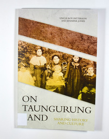 Marysville & District Historical Society
Book, Jennifer Jones et al, On Taungurung Land-Sharing History and Culture, 2020
... Marysville yarra-valley-and-the-dandenong-ranges On Taungurung Land ...On Taungurung Land: Sharing History and Culture is the first monograph to examine how the Taungurung Nation of central Victoria negotiated with protectors and pastoralists to retain possession of their own country for as long as possible.Front cover has a photograph of the Patterson family c.1904. Back cover has the blurb of the book and information about the authors of the book.non-fictionOn Taungurung Land: Sharing History and Culture is the first monograph to examine how the Taungurung Nation of central Victoria negotiated with protectors and pastoralists to retain possession of their own country for as long as possible.taungurung nation, elder uncle roy patterson, jennifer jones, acheron aboriginal station, mohican aboriginal station, central victoria, history, white settlement -
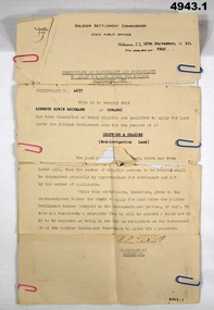 Bendigo Military Museum
Certificate, Certificate of eligibility and suitability for soldier settlement
1. Foolscap size sheet (see condition) Letterhead is for the soldier Settlement Commission. State Public Offices. Tel F 0234. Dated Melb 16 Sep 1947. Letter No 8945. In the text is Cert No. 4677 for Kenneth Edwin Beckman of Cowangi. The purpose of the land is for cropping and grazing (non irrigation land) 2. Letter quarto size paper. Letterhead of Australian Mil Forces. Tel No. M 45966 Ext 30. Victoria Echelon and records 291 Lonsdale St Melbourne dated 2 Nov 1945. In the text is printed EX V64354 K E Beckman. Cert of Discharge 294425. RAS Badge No. A 99448. Will (AAF A.131) One..admin record, ww2 -
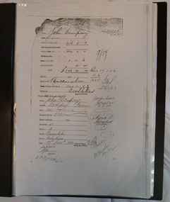 Wycheproof & District Historical Society Inc.
Dempsey Book, Dempsey Land Selection, 2003l
Mr Dempsey and family were the first selectors to arrive at Mt Wycheproof 1872 or early 1873. One Dempsey Land Application is dated 15-3-1873.Factual documents obtained from a Melbourne archive show settler,John Dempsey,securing land at Wycheproof. Several official Lands Department correspondence provides evidence of Dempsey's early land acquisition at the beginning of the town's farming history and settlement from 1872 - 1882. This is an A3 sized Display book with grey spine. Comprises official Lands Department Papers detailing Mr John Dempsey's Land Applications and acquisition at Wycheproof. Dated documentation is from 1872 through to 1882.Locally researched references give an overview about the Dempsey family.dempsey, land -act, bunguluke -
 Wycheproof & District Historical Society Inc.
Bunguluke Map, Bunguluke District In 1923, 27.2.1923
By 1881 Bunguluke was a small settlement as recorded, December 5, in the Charlton "Mercury". It reports that in that year Draper's Store, Hotel and Post Office and residence at Bunguluke North was totally destroyed by fire. For years now there has been little sign of community life with houses few and far between and acreages have gone into larger holdings. The map references land blocks and owners for that era.This important map shows the local land ownership and local features that existed in 1923. This is a photocopied black and white map of Bunguluke in the County of Kara Kara, Number L5149. Marked - Photo Lithographed by W.J. Butson 27.2.1923. The details include numbers of allotments, property owners, roads, rivers. The boundaries marked are the Parish of Jeruk, Parish of Wycheproof, Parish of Cooroopajerrup. Wycheproof township location is shown with the Scale of Chains. Bunguluke maps for other years are also in the collection.map, bunguluke, jeruk, wycheproof, cooroopajerrup -
 Greensborough Historical Society
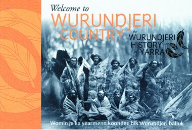
Booklet, Emily Fitzgerald et al, Welcome to Wurundjeri country: the Wurundjeri history of Yarra, 2014
Brief history of the Wurundjeri-willam people of the area now known as the City of Yarra, from pre-settlement times to the present.44p., paperback, printed in black and orange, illus.wurundjeri willam, city of yarra, aborigines - victoria -
 Phillip Island and District Historical Society Inc.
Photograph, 1978/79
Chicory Kiln alongside the house of Mr T Woods in Settlement Road, East Cowes, was built in approx. 1870. It had 18" thick mud brick walls at the core.Photograph of Chicory Kiln on Settlement Road, East Cowes, on land owned by Mr. T. Woods.local history, photographs, buildings - historical, housing, rural industry, coloured photograph, john cook, phillip island, t woods -
 Greensborough Historical Society
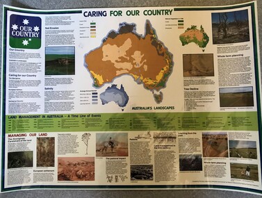
Poster, National Farmer's Federation et al, Caring for our Country, 1988c
A timeline of land management including indigenous care and the impact of European settlement from 1988 to 1987. Includes maps showing present land use and vegetation coverage in 1788. Prepared by Tim Gurry for the National Farmer’s FederationLaminated poster, printed in colour on one side.land management, farming, salinity -
Glenelg Shire Council Cultural Collection
Book, People of the Lake - the story of Lake Condah Mission, n.d
27,000 years ago molten lava pouring from the eruption of Budjbim (Mt. Eccles) formed Lake Condah and the unique landscape that surrounds it. Over time this area known as "The Stony Rises" or "The Stones" became an important geological area for Koories and, later, Europeans.12 page A4 size booklet, cream with brown print.27,000 years ago molten lava pouring from the eruption of Budjbim (Mt. Eccles) formed Lake Condah and the unique landscape that surrounds it. Over time this area known as "The Stony Rises" or "The Stones" became an important geological area for Koories and, later, Europeans.aboriginal history, gunditjmara, lake condah, mission history, budj bim -
 Greensborough Historical Society
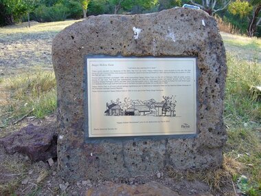
Photograph - Digital Image, Happy Hollow plaque, 05/02/1840o
The land surrounding Happy Hollow farm at Plenty was purchased by Francis Wickham in 1840. The land was later subdivided and held by various owners including Charles Partington (1875) and John McLaughlin who leased the property in 1892 to Robert Emmett Whatmough who erected the first dwelling on the property. The land was later owned by Mrs Betty Bell and was purchased by Parks Victoria in 1994 to form part of the Plenty Gorge Parklands. This plaque was laid by Plenty Historical Society.Happy Hollow was an example of early settlement along the Plenty River.Digital copy of colour photograph. Plaque at Plenty Gorge Parklands.plenty river, happy hollow, happy hollow farm, robert emmett whatmough, betty bell, john mclaughlin, charles partington, parks victoria -
 Greensborough Historical Society
Article, Printer Unknown, Greensborough, 1840o
Details the history of the current Greensborough township. It also mentions the early settlement of Kangaroo Point.Mentions early settlers such as William Poulter, James Chapman, James Mann and Edwin Willis Magger (Maygar).2 page printed document outlining the activities and motives of Edward Bernard Green, an early owner of the area of land that became Greensborough.Pencilled words on front page. greensborough, kangaroo point, edward green, poulter, mann, chapman, magger, mayger, melbourne to sydney mail contract -
Greensborough Historical Society
Maps, Plenty River, 1837o
These maps show the land use along the Plenty River. Both Aboriginal and white settlements are shown.Set of maps showing the Plenty River. -
 City of Moorabbin Historical Society (Operating the Box Cottage Museum)
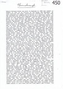
Manufactured Glass, milk bottle 'Black Rock Dairy', 20thC
Alfred R Varcoe was a dairyman with stables, cart shed and his house in Eliza Street, Black Rock, Victoria. Dairy farming was established early in the settlement of the Brighton / Moorabbin area following the Dendy's Special Survey 1841 and subsequent land sales c1850. The produce was taken to feed the population of Melbourne and local residents.A clear glass ,1 pint , milk bottle used by Black Rock Dairy, MelbourneTHIS BOTTLE CONTAINS/ MILK / BOTTLED FOR SALE BY / BLACK ROCK MODEL / DAIRY / BLACK ROCK / BOTTLE IS THE PROPERTY OF THE ABOVE / IT IS OWNED AND CANNOT BE LEGALLY USED BY OTHERS/ ONE IMPERIAL PINT on base 440market gardeners, early settlers, farmers, dairies, milk production, moorabbin shire, moorabbin, cheltenham, black rock, brighton, dairy farmers, bottles, glass manufacture, varcoe alfred r; black rock dairy, dairy farmer, dairy products sales and deliveries, -
Glenelg Shire Council Cultural Collection
Souvenir - Tea Towel - Maretimo, Portland, n.d
From the National Trust register: Statement of Significance Maretimo, a 22 room single storey Australian Colonial Georgian style mansion set on a prominent bluff overlooking Portland harbour, was erected c. 1854 for John Norman McLeod. The design of Maretimo, which is constructed of basalt ashlar with fine-axed parapet entablature, delicate open timber work verandah and Regency interior, has been tenuously attributed to Adelaide architect James Barrow. Maretimo is rivalled only by the stylistically similar Henty residence, Burwsood of 1853 by James Barrow, as perhaps the finest Australian Colonial Georgian style residence erected within the first twenty years of settlement in Victoria. The residence, which was occupied for twenty years by distinguished English-born gentleman parliamentarian, pastoralist and former Van Deimen's Land settler, J H McLeod, is now notable for the disciplined facade and elegantly crafted interiors. Maretimo has been meticulously maintained and is presented in near perfect original condition. The interiors have been sensitively enhanced and redecorated.Linen souvenir tea towel 'Maretimo'. Green and black on cream. 'MARETIMO' at top, front view of Maretimo beneath, then map of locaion, then view from air. 'HISTORIC HOME PORTLAND, VICTORIA' beneath 'Pure Linen', bottom right.historic building, historic homestead, maretimo, henty, souvenir -
 Greensborough Historical Society
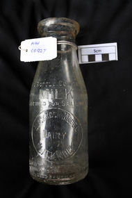
Newspaper clipping, Fields give way to business boom, 1993_
Tells some of the story of the settlement of Greensborough and Lend Leases' gradual take over of Greensborough shopping area. In Canberra Times Wednesday 17 November 1993, page 27: Melbourne: Lend Lease Corp Ltd is to undertake a $600 million redevelopment of two suburban Melbourne shopping centres, at Dandenong and Greensborough; to be built in conjunction with Australia's largest retailer; Coles Myer Ltd. The project will create about 2000 jobs; 1000 during construction and 1000 in long-term retail.Has some history of Greensborough and records the average land prices in 1993. A black and white Sunday Age newspaper story. Includes map and photograph of resident.greensborough, lend lease, 1993, land prices -
 Eltham District Historical Society Inc
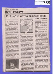
Photograph, Liz Pidgeon, Heritage Excursion; Eltham Lower Park Walk and Talk, 1 July 2017, 1 July 2017
Information Board titled: Family Nature Trail - History of the land of Lower Eltham Park Newsletter No., 234, June 2017 Heritage Excursion - Saturday 1st July - Eltham Lower Park - Walk and Talk Eltham Lower Park has played an important part in the history of our area since the early days of European settlement when it was used by local residents as an informal racecourse. Prior to that its location at the junction of the Diamond Creek and the Yarra River made it an important meeting place for the Wurundjeri people. The park combines formal elements and sporting facilities with remnant bushland that is of environmental significance. It is home to sporting and horse riding clubs, popular play spaces and the Diamond Valley Miniature Railway, which attracts large numbers of visitors. The park will be the venue for our July excursion which will comprise a walk of about 3.5 km around the park and adjacent areas. Along the way we will discuss the history and natural history of the area. The path along the creek and the river provides a pleasant and scenic walk. This walk on Saturday 1st July is about 3.5 km in length and will take 2 to 2.5 hours. It will start at 2pm at the Main Road car park at the front of the park. (Melway ref 21 H 10). Born Digitalheritage excursion, activities, eltham district historical society, eltham lower park, information board, trail -
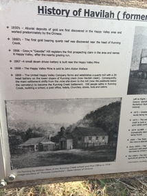 Kiewa Valley Historical Society
Papers - Havilah Cemetery, Havilah Cemetery Formerly Running Creek Cemetery
In 1889, 24 residents of the Running Creek and surrounding district submitted a petition to the Minister of Lands, Melbourne requesting land for a cemetery. Their request was granted. The Cemetery was decommissioned in the early 1950s and the last trustee for the cemetery died in 1986. There is a wooden fence around the boundary (May 2024). One paper lists 29 names in the Burial Register 1861-1948. The last two sheets record the history as a timeline from the 1850s to the 1900s. Havilah was a gold mining settlement from the 1850s located 20km west of the Kiewa Valley and in the Ovens catchment near Myrtleford.Five black and white A4 pages stapled together. Copies of the sign erected at the gate of 'Havilah cemetery formerly Running Creek Cemetery'. Also the 'History of Havilah formerly Running Creek'havilah, running creek, cemetery -
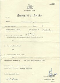 Warrnambool and District Historical Society Inc.
Document, Australian Army Statement of Service, C 1976
He served from December 1941 to July 1942 in the Citizen Military Forces and from July 1942 to September 1944 in the Australian Imperial Forces. His reason for discharge was reserved occupation. He held the rank of corporal in 26th Motor regiment. He was born in Colac 19/11/1919 to Ernest Swan and Daisy Johnson. He died 04/08/2009 and is buried at the Warrnambool cemetery. During his life he farmed a soldiers’ settlers block in the Grasmere area, north of Warrnambool. The soldiers' settlement program was instigated after both world wars whereby land was made available to returning soldiers. Some of the land was Crown land and some was acquired. This document is an official statement of his service.This document has social significance and interest as it is representative of thousands of local men who served in World War 2. It is a link also to the Soldiers' settlement programCream paper with black text. Personal details of Ernest Henry Swan have been typed into fields. text in the centre of the reverse.Signed E H Swan. date of issue is 11/08/1976.Army number VX88010.warrnambool, e h swan, e h swan statement of service -
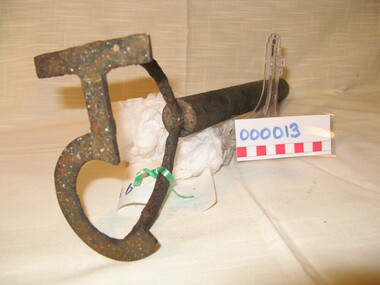 Warrnambool and District Historical Society Inc.
Functional object - Farming Equipment Branding Iron, Circa 1840
Armyne, George and Lemuel Bolden were original landholders of large parts of land in the Western district. Portions of it extended from Pirron Yallock in the East to almost as far as Portland. The head station was at Grasmere. They were noted breeders of shorthorn cattle in fact they were some of the first men to bring the breed to Victoria and thus helped to pioneer the Australian Shorthorn breeding Industry. This branding iron was found at Lyall Park, originally 640 acres selected by William Lyall at Cooramook. It is believed to be a branding iron dating from when the land was occupied by the Bolden Brothers. The Bolden Brothers were the first to erect considerable lengths of fencing in the Warrnambool area. If this item is an authentic Bolden piece of property then it is the oldest artefact from the time of white settlement that is held by the Warrnambool and district Historical society. The item itself while a common farming implement and which was found on a farm originally owned by the Bolden Brothers is a link with the earliest part of Warrnambool’s history.Short, round wooden handle with metal brand in the shape of the letter T with two thirds circle attached to vertical part of T. Daub of paint at end of handle . T 5Paper label attached with green tape with 931 in texta and hand written on back,” branding iron reputed to have been used by Bolden Bros Grasmere c 1840. warrnambool, bolden brothers, armyne bolden, george bolden, lemuel bolden, branding iron, shorthorn cattle -
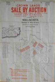 Orbost & District Historical Society
maps, early 1900s
... for farming and residential settlement. Orbost-land-1900s maps posters ...796.1 - Crown Land Sale by auction in the township of Mallacoota on Wednesday January 1920 at 2pm. 796.2 - Snowy River farms , 630 acres of river flat land at Orbost on Wednesday April 28, 1909 at 2.30pm. 796.3 - Famous Orbost Flats - "Important Sale of Snowy River Land" , 900 acres subdivided into 13 choice farms on Wednesday 1st December 1920 at 2.30pm. 796.4 - "Second Great Sale in James' Subdivision", adjoining town of Orbost on 16th May, 1919 at 2pm. 796.5 - "Subdivisional Sale Brooklands Estate", 5 rich Snowy River farms on Wednesday 23rd February at 2.30 at Orbost on account of James Hossack Esq. 796.6 - "Subdivisional sale of Splendid Residence Sites and Handy Small Paddocks" adjoining the progressive town of Orbost on 5th March 1915 at 11am at the rooms of H.James & Co. 796.7 - This is a contract drawing on waxed paper. Crossing near Harbecks Cunninghame Signed and traced N. Anderson 17/11/00. 796.8 - A plan and specification on waxed paper. Shire of Orbost Cunninghame Road - signed by the shire engineer. 796.9 - This is a hand drawn map of Orbost Cunninghame Road, November 1896. 796.10 - This is a hand drawn cross-section of a culvert on the Orbost Cunninghame Road. 796.11 - This is a plan of a culvert on Tabbara Road, 13th January 1899 796.12 - This is a poster for an "Important Subdivisional Sale' for land near Orbost Bridge, on Wednesday 16th March 1921 at the rooms of H. James & Co. These documents are an important part of Orbost history in that they show how the town and surrounding areas were subdivided for farming and residential settlement.A set of twelve maps, plans and land sale posters .orbost-land-1900s maps posters h.james -
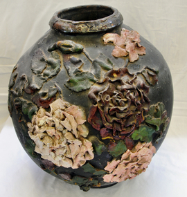 Orbost & District Historical Society
ginger jar, Pre 1893 floods in Orbost
In the early days of Orbost many Chinese were engaged in land clearing or had arrived when gold was discovered in East Gippsland in the 1840's. They lived in camps along the Marlo Road and houses were usually built on stilts. They left after the 1893 floods.This object has aesthetic appeal. It is an object which belonged to the very early settlement days of Orbost.Huge, ornate Chinese ginger jar. Four raised hand- painted pink roses on front. Jar itself is matt black. Looks more like a vase than a ginger jar. Ceramic.Some Chinese writing to left hand side of roses.ceramics, ginger jar, container - domestic, vase -
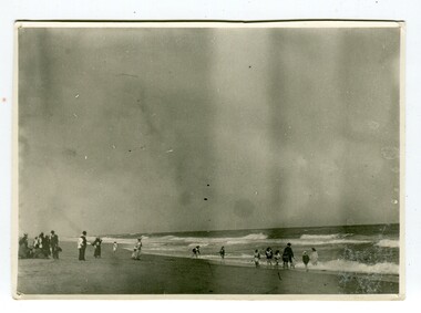 Orbost & District Historical Society
black and white photograph, January 1901
This photograph was taken at the "old station" at Corringle near Orbost. It was a popular picnic spot. Late in 1857 Mr Thomas T. Stirling took over Corringle Run ("Corringle" means "shallow water"). Mr Stirling and his family came from the wester district - Winchelsea. He settled at the Old Station. A few people were employed at the Orbost Stationb and there was settlement on the Orbost flats, Mr T. T. Stirling held the land from Lake Tyrers to Bemm River as a cattle run. About 1888 he became Secretary of the new Tambo Shire.This is a contemporary pictorial record of rural family life in Orbost in the early 20th century.A black / white photograph showing people on a beach with some in the water. those on the sand are dressed formally - men wearing suits and hats, the ladies in long dresses and hats.on back - "Picnic at OLD STATION Jan 1901"orbost-station orbost-family-life recreation -
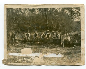 Orbost & District Historical Society
black and white photograph, 1923
This photograph was taken at the "old station" at Corringle near Orbost. It was a popular picnic spot. Late in 1857 Mr Thomas T. Stirling took over Corringle Run ("Corringle" means "shallow water"). Mr Stirling and his family came from the wester district - Winchelsea. He settled at the Old Station. A few people were employed at the Orbost Stationb and there was settlement on the Orbost flats, Mr T. T. Stirling held the land from Lake Tyrers to Bemm River as a cattle run. About 1888 he became Secretary of the new Tambo Shire. In the photograph L-R are; Hilda Kerr; Myra Malcolm; Marion Nixon; Bess Goudie (teacher); Mary Gilbert; Gwen Hobson (teacher); Pen GilbertOrbost High School / Orbost Secondary College has played a significant part in the education of senior students in the Orbost district . It is the sole senior educational institution. This item is representative of its history. It is a useful reference tool.A black / white photograph of a group of young women sitting on a log in a clearing in a bush setting. Five are in school uniform. On the left is a horseeducation-orbost orbost-higher-elementary-school recreation old-station-corringle -
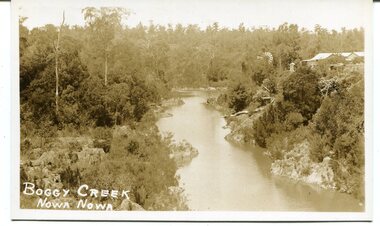 Orbost & District Historical Society
black / white photograph, late 19th - early 29th century
The building in this photograph of Boggy Creek is probably the first Nowa Nowa Hotel built by Moses Faithfull, in 1890. Moses Faithful came to Australia from England with his parents on the Royal Consort in 1844. After living at Bulla, Pakenham and Wurruk he and his wife moved to Hospital Creek in about 1885 where he took up the first selection of land at Upper Hospital Creek. As well as farming he built the first hotel at Nowa Nowa in 1890. He had charge of the hotel until 1895 when he sold to Mary Stirling. Moses died on 8th July 1901, aged 66, at the residence of his son-in-law, David Price, at Newmerella, and buried in the Orbost cemetery.This hotel was built in 1890 and doubled as a coaching stop on the inland route. Settlement grew up around the hotel. It was sold 1895 to Mary Stirling who husband own the land the hotel stood on. The hotel burned down on 29 July 1955. This is a pictorial record of Nowa Nowa in the late 19th century.A black / white photograph / postcard of a creek with a building on the rightside. a windmillis to the left. The banks of the creek are well-vegetated.on front - bottom left -"BOGGY CREEK NOWA NOWA"boggy-creek-nowa-nowa -
 Orbost & District Historical Society
black and photograph / postcard, 1.4.1908
This postcard was sent to Annie Gilbert (Mrs John Gilbert) of Tullagoota, Orbost. It was written by "Grace", probably her sister, Grace Cameron Annie Gilbert was the daughter of John Cameron who selected the first land on the Snowy River flats. This is a photograph of the original Orbost / Snowy River Bridge , a suspension bridge which opened in 1893. It has been taken when the Snowy River was in flood. It is similar to other photographs held in The State Library, Victoria. The Snowy River Mail and Tambo and Croajingolong Gazette Sat 12 Aug 1893 records the opening of this bridge as "the most important public event that has yet been commemorated in Eastern ......The Messrs McLeod, with whom the first settlement of this district is generally associated, took up their residence on the eastern bank of the Snowy River about the year 1841 or 42. The late Mr W. Roadknight and Mr T. T. Stirling took possession of the territory on the western side of the Snowy about 35 years ago. During the occupation of the country by cattle owners, very little progress was made in the way of roads and bridges, and except to the hardy and lexperienced bushman, it might have been generally regarded as inaccessible. About the year 1877, however, the late Mr James Robertson eldest son of Mr James Robertson, of Lochend farm, selected land now occupied by his father, about four miles from Orbost on the west bank of the river, Mr John Cameron visited the. district shortly after a .tour of inspection and returned later with his brothers, James and Alick Gameron, but found that during their absence Mr Ernest Watt had found his way on the scene and pegged out a selection, thus anticipating the advent of the Camerons by about 12 hours. We understand that a Mr Kidd, who selected the property now occupied by Mr W. J. Ross, at Pumpkin Point, was one of the earliest batch of settlers.........."This item is associated with Annie Gilbert (nee Cameron) reported to have been the first white girl to be born in Orbost. It is a pictorial record of the suspension bridge over the Snowy River which has since been replaced twice.A faded black / white postcard of a bridge across a river. There are cattle in the river and the banks are tree-covered.on back - a hand-written letter addressed to Mrs J. Gilbert Tullagoota Orbost.cameron-annie suspension-bridge-orbost snowy-river-orbost -
 Orbost & District Historical Society
display cabinet and tools
This display was put together by the Curlip Committee and used as promotion in the shed during the construction of Curlip 11 A community project, this boat was constructed out of local hardwood timbers utilizing the traditional skills of wooden boat builders and is powered by a steam engine. Paddle Steamer Curlip II is a replica of an historic paddle steamer of the Snowy River, in Far East Gippsland, Victoria. The original Paddle Steamer Curlip was built by Sam Richardson and his sons Mark, Albert and Frank, at their sawmill at Tabbara, a pioneering settlement on the Brodribb River, a tributary of the Snowy River. The keel was laid on 14th October 1889 and PS Curlip was launched in 1890. The name “ Curlip” is derived from the indigenous name for the area where Tabbara is located and includes land to the east of the Snowy and Brodribb Rivers towards Cape Conran. PS Curlip was registered in 1893 and the Passenger Certificate issued on 30th January 1903 to Captain Alan Richardson by the Marine Board of Victoria entitled her to carry 25 passengers and only 10 passengers when engaged in towage service. Two children under 12 years of age to be reckoned as one passenger. PS Curlip towed five barges at a time, traveling upstream as far as Bete Bolong, 20 km upstream of the mouth to collect produce to be transferred to schooners near Marlo. She towed vessels in and out through the Snowy river entrance and was also used for social functions such as Sunday School picnics. She was the main means of transport for imports and exports on the Snowy River for almost 30 years. The Curlip era ended abruptly on Friday 28th February when a flash flood carried her and 2 barges down river and out to sea, where she washed ashore at Marlo and broke up.More than eighty years after the original Paddle Steamer Curlip was wrecked at sea, the Orbost community launched a replica which it hoped would draw tourists to the region. The P.S. Curlip II, is based on drawings of the original Curlip that made its home in the Snowy and Brodribb Rivers of East Gippsland in the 1890s and early 1900s, It took six years of planning and hundreds of hours of volunteer work from the local community.A display cabinet containing tools and sundry items related to the Paddle Steamer Curlip. (More information on individual items in Catalogue 1400-1600)p.s.curlip richardson-samuel boat-building-tools transport -
 Ringwood and District Historical Society
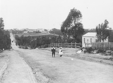
Photograph, Addison home 1902 Ringwood in background
Black and white photograph of scene showing unmade road with two children, a boy and a girl standing outside a small wooden building. Lady is sitting by the side of road. Road dips down to a bridge then rises again towards distant settlement in background. (3 copies)Typed below enlarged photo, "Addison home, 1902 - Opposite present St. Paul's, Warrandyte Road". Written on backing sheet, "Andersons Creek Rd. 1903. Mrs. Addison (Annie Kennedy) and family - Annie, born 1897 and William. Their house at right was on a 5 acre block. Ringwood in background". Backing sheet of another copy reads, "Andersons Creek Road 1902 (Warrandyte Rd. looking south). Mrs. Addison (Annie Kennedy) and family. Annie (Jnr), born 1897 and Samuel John James William, born 1894. Their home, at right, was on a 5 acre block. Ringwood in background - burned down by pet magpie. T. Grant's land ploughed - now Eastland. Adelaide St. seen on right of it. Mullum Creek Bridge at foot of hill". Typed below this photograph, "Warrandyte Rd. Ringwood looking south from near Mullum Rd. Ringwood in background. Maroondah Highway at top of hill with Mullum Creek bridge seen in dip - 1902". -
 Orbost & District Historical Society
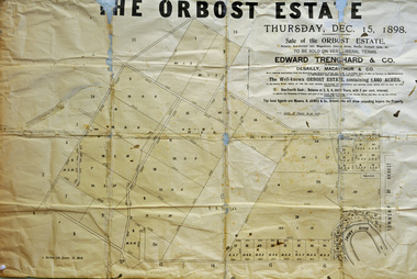
poster, 1898
This poster was made for the sale of the 1,440 acres of Orbost Station after the death of Sir William Clarke. It was sold by Edward Trenchard & Co. which was the oldest Stock and Station agent in Victoria assisted by Desailly, Macarthur & Co were livestock experts. Sir William Clarke had taken over the Orbost run from the McLeods in 1870. When Sir William died the property was owned by his son, Rupert who offered the land for sale at 4 pounds per acre. No sale resulted and the property was leased for a few years until in 1898 it was subdivided and sold to many of Orbost's first families. (info. from In Times Gone By- Deborah Hall)This is an important reminder of the very early history of the settlement of Orbost.A rectangular paper poster for the sale of the Orbost Estate on Forest Road, Orbost. It is dated "Thursday Dec 1898" and was made for the sale of the 1,440 acres of Orbost Station after the death of Sir William Clarke. The poster gives written details of the sale and a plan of the property.orbost-station clarke-sir-william orbost-estate -
Marysville & District Historical Society
Article (item) - Museum Victoria Australia Article, Museum Victoria Australia, Aboriginal Land, Unknown
A brief history of the Kulin clan in Victoria.A brief history of the Kulin clan in Victoria.kulin clan, great dividing range, yarra river, goulburn river, tonne-be-wong, toole-be-wong, donne-be-wong, mount riddell, ben cairn, donna buang, port phillip settlement, john batman, james dredge, port phillip protectorate for aborigines, duang wurrung, king parrot creek, acheron river, mitchellstown, william le souef, murchison, woi wurrung, boon wurrung, warrandyte, mordialloc, little river, william thomas, acheron station, mohican run, john green, mohican station, badger creek, healesville, coranderrk, black's spur, christmas bush, prostanthera lasianothos, geringdah