Showing 281 items
matching leather work
-
 Brighton Historical Society
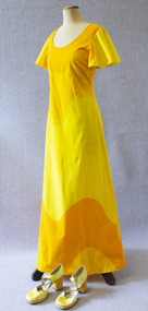
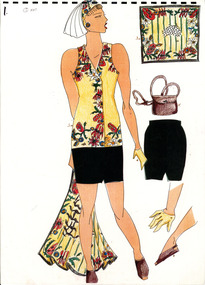
Dress and shoes, circa late 1960s
Heather Leonard wore this outfit to a Brighton Primary School fundraiser in the late 1960s. She hand painted the white platform heels to match her yellow and orange dress, and her husband Paul wore similarly bright colours with a mustard yellow and purple shirt. Heather was born in the Bayside area, initially working as a nurse and later as a yoga teacher. She and Paul lived together in Male Street for forty years until his death in 2002. Paul worked in advertising and later became a painter, mainly of Australian icons.Floor length dress (.1) of printed cotton with yellow and orange pattern, with scoop neck, short flared sleeves and zip at the back. Platform shoes (.2) with block heel. White leather, hand painted yellow and orange.heather leonard, paul leonard, brighton primary school, 1960s -
 Brighton Historical Society
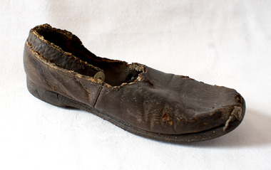
Shoe, Child's shoe, 19th century
This child's shoe was found underneath the floorboards of the historic Brighton house St Ninian's, 10 Miller Street, during its demolition in September 1974. One of Brighton's earliest buildings, St Ninian's was built around 1841 for merchant, politician and former British naval officer George Ward Cole (1783-1879) and his family. Ward Cole was a prominent member of Victorian society in the mid-to-late nineteenth century. He served in the Victorian Parliament from 1853-55 and 1859-79. His seaside home in Brighton was a fashionable rendezvous for many important identities who shaped Melbourne’s history. Victoria’s first royal visitor, Prince Alfred, Duke of Edinburgh, was a guest there in 1867. It is possible the shoe belonged to one of the Ward Cole children. During the demolition of St Ninian's in September 1974 the Brighton Historical Society's then-secretary, Rosalind Landells, snuck onto the work site in the hope of saving some part of the building and its history. She found this shoe under the partially-demolished floor of the house.Brown leather child's shoe with an ankle strap, fastening with a mother-of-pearl button. Heavily deteriorated.Handwritten in pencil on the sole of the shoe: "Found under floor at St Ninians 1974 Sept during demolition".st ninians, george ward cole, children's clothing, 19th century -
 National Wool Museum
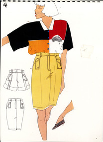
Work on paper - Women's Village/Travel Uniform Design Drawings, Wendy Powitt, c. 1992
A set of laminated A3 sketchbook pages depicting designs for the 1992 Barcelona Olympic Women's Village/Travel Uniform designed by Wendy Powitt. On the 1992 Barcelona Olympic Games donor Doug Pleasance wrote- The 1992 Barcelona Olympic Games saw an evolutionary change in designer selection. A Declaration of Interest Form was communicated to over forty potential designers. The task and especially tight timelines that were involved deterred many aspirants, however, there remained eight designers with the potential we were seeking. These eight designers were paid $3,000 per submission and the winning designer, Wendy Powitt, was paid $15,000. For the first time the judging panel included two athletes, one male swimmer and one female basketballer, their influence was pivotal. The village clothing was designed to be a highly visible garment meaning that it was easy to "Spot the Aussies" and helped to contribute to a good team spirit. Blocks of contrasting colours were a feature of the pure wool shirts. A newly developed stretch 50:50 wool/cotton fabric by Bradmill was made into shorts and jeans by Fletcher Jones.8118.1- A laminated A3 sketchbook page depicting a design for the 1992 Barcelona Olympic women's Village/Travel Wear Uniform. The main drawing shows the design for a pair of yellow shorts with a yellow and green printed, striped shirt, cinched at the waist by a brown woven belt. At the bottom of the page is a detailed drawing of the weave of the belt with an Australia shaped belt buckle. A small drawing to the right of the main image also details a small bag/pouch that attaches to the belt. 8118.2- A laminated A3 sketchbook page depicting a design for the 1992 Barcelona Olympic women's Village/Travel Wear Uniform. The main drawing shows the design for a pair of yellow shorts paired with a block colour shirt in green, red, white and yellow with a symbol in the shape of Australia on the right side of the shirt. There are small detail images of shorts and a skirt to the left of the main image and a detail drawing of a brown leather shoe to the right.1992 barcelona olympics, sport, athletes, fashion, design, artwork, drawing, uniform -
 National Wool Museum
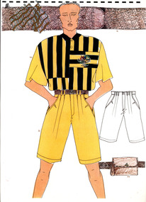
Work on paper - Men's Village/Travel Uniform Design Drawing, Wendy Powitt, c. 1992
A laminated A3 sketchbook page depicting a design for the 1992 Barcelona Olympic Men's Village/Travel Uniform designed by Wendy Powitt. On the 1992 Barcelona Olympic Games donor Doug Pleasance wrote- The 1992 Barcelona Olympic Games saw an evolutionary change in designer selection. A Declaration of Interest Form was communicated to over forty potential designers. The task and especially tight timelines that were involved deterred many aspirants, however, there remained eight designers with the potential we were seeking. These eight designers were paid $3,000 per submission and the winning designer, Wendy Powitt, was paid $15,000. For the first time the judging panel included two athletes, one male swimmer and one female basketballer, their influence was pivotal. The village clothing was designed to be a highly visible garment meaning that it was easy to "Spot the Aussies" and helped to contribute to a good team spirit. Blocks of contrasting colours were a feature of the pure wool shirts. A newly developed stretch 50:50 wool/cotton fabric by Bradmill was made into shorts and jeans by Fletcher Jones.A laminated A3 sketchbook page depicting a design for the 1992 Barcelona Olympic men's Village/Travel Wear Uniform. The main drawing shows the design for a pair of yellow shorts, a green and yellow striped shirt with the Australian emblem on the right breast of the shirt and a brown leather woven belt. The top of the page shows a detailed drawing of the belt weave with a symbol of Australia as the belt buckle. To the right of the main image is a detailed drawing of the shorts as well as a drawing of a leather pouch that is attached to the belt.1992 barcelona olympics, sport, athletes, fashion, design, artwork, drawing, uniform -
 National Wool Museum
Work on paper - Women's Opening/Closing Ceremony Uniform Design Drawings, Wendy Powitt, c. 1992
... as well as a depiction of a brown leather bag. Work on paper ...A set of laminated A3 sketchbook pages depicting designs for the 1992 Barcelona Olympic Women's Opening/Closing Ceremony Uniform designed by Wendy Powitt. On the 1992 Barcelona Olympic Games donor Doug Pleasance wrote- The 1992 Barcelona Olympic Games saw an evolutionary change in designer selection. A Declaration of Interest Form was communicated to over forty potential designers. The task and especially tight timelines that were involved deterred many aspirants, however, there remained eight designers with the potential we were seeking. These eight designers were paid $3,000 per submission and the winning designer, Wendy Powitt, was paid $15,000. For the first time the judging panel included two athletes, one male swimmer and one female basketballer, their influence was pivotal. Opening Ceremony Uniform included a lightweight wool fabric printed with floral designs that had been inspired by the work of Australian artist Margaret Preston. This included: Lightweight W/PE shorts by Fletcher Jones in Foster Valley Fabric, socks by Holeproof and footwear by Hush Puppy.8120.1 - A laminated A3 sketchbook page depicting a design for the 1992 Barcelona Olympic Women's Opening/Closing Ceremony Uniform. The main drawing shows the design for a dark green skirt, a yellow printed sleeveless button up shirt, a matching headband and scarf, yellow gloves and brown leather shoes. To the right of the main image are five detail drawings of the skirt, gloves, shoes and scarf as well as a depiction of a brown leather bag. 8120.2 - unnumbered- mounted on green card this sketchbook page depicts a design for the 1992 Barcelona Olympic Women's Opening/Closing Ceremony Uniform. The main drawing shows the design for a dark green skirt, a yellow printed sleeveless button up shirt and yellow gloves. 8120.3 - unnumbered- A laminated A3 sketchbook page depicting a design for the 1992 Barcelona Olympic Women's Opening/Closing Ceremony Uniform. The main drawing shows the design for a dark green skirt, a yellow printed sleeveless button up shirt, a matching headband and scarf, yellow gloves and brown leather shoes. To the right of the main image are five detail drawings of the skirt, gloves, shoes and scarf as well as a depiction of a brown leather bag.1992 barcelona olympics, sport, athletes, fashion, design, artwork, drawing, uniform -
 National Wool Museum
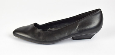
Uniform - 1992 Barcelona Olympic Games Women's Black Shoe, Wendy Powitt, c. 1992
Uniforms for the 1992 Barcelona Olympic Games were designed by Wendy Powitt in conjunction with the AWC. Doug Pleasance, donor of these items, worked for the AWC and closely with Wendy Powitt, obtaining these uniform examples. About the Olympic Uniforms Doug wrote- 1. The Official Uniform which was used for travel and all official functions. This included: a tailored blazer and trouser/skirt (all water repellent) by Fletcher Jones, pure wool olive-green faille fabric by Foster Valley, cotton PE formal shirt by Pelaco, pure wool knitwear by Spangaro, printed wool tie by T D Noone, wool nylon socks by Holeproof and footwear by Hush Puppy. 2. Opening Ceremony Uniform a lightweight wool fabric printed with floral designs that had been inspired by the work of Australian artist Margaret Preston. This included: Lightweight W/PE shorts by Fletcher Jones in Foster Valley Fabric, socks by Holeproof and footwear by Hush Puppy. 3. Village Clothing was designed to be highly visible garments to make it easy to spot the Aussie and helped to contribute to good team spirit. This included: A pure wool shirt featuring blocks of contrasting colours, and a newly developed stretch 50:50 wool/cotton fabric by Bradmill was made into shorts and jeans by Fletcher Jones.Women's left black leather heeled shoe, manufactured by Hush Puppies. Simple and unadorned in style with a rounded toe. Only the left shoe.1992 barcelona olympics, sport, athletes, fashion, design, uniform -
 National Wool Museum
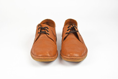
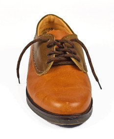
Uniform - 1992 Barcelona Olympics Men's Tan Shoes, Wendy Powitt, c. 1992
Uniforms for the 1992 Barcelona Olympic Games were designed by Wendy Powitt in conjunction with the AWC. Doug Pleasance, donor of these items, worked for the AWC and closely with Wendy Powitt, obtaining these uniform examples. About the Olympic Uniforms Doug wrote- 1. The Official Uniform which was used for travel and all official functions. This included: a tailored blazer and trouser/skirt (all water repellent) by Fletcher Jones, pure wool olive-green faille fabric by Foster Valley, cotton PE formal shirt by Pelaco, pure wool knitwear by Spangaro, printed wool tie by T D Noone, wool nylon socks by Holeproof and footwear by Hush Puppy. 2. Opening Ceremony Uniform a lightweight wool fabric printed with floral designs that had been inspired by the work of Australian artist Margaret Preston. This included: Lightweight W/PE shorts by Fletcher Jones in Foster Valley Fabric, socks by Holeproof and footwear by Hush Puppy. 3. Village Clothing was designed to be highly visible garments to make it easy to spot the Aussie and helped to contribute to good team spirit. This included: A pure wool shirt featuring blocks of contrasting colours, and a newly developed stretch 50:50 wool/cotton fabric by Bradmill was made into shorts and jeans by Fletcher Jones.Men's tan coloured shoes with appliqued leather design attached to the laces creating a wave-like point on the sides of the shoes.1992 barcelona olympics, sport, athletes, fashion, design, uniform -
 National Wool Museum
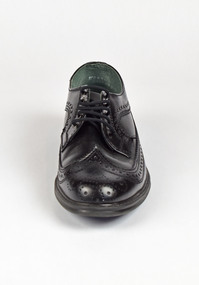
Uniform - 1992 Barcelona Olympics Men's Black Shoe, Wendy Powitt, c. 1992
Uniforms for the 1992 Barcelona Olympic Games were designed by Wendy Powitt in conjunction with the AWC. Doug Pleasance, donor of these items, worked for the AWC and closely with Wendy Powitt, obtaining these uniform examples. About the Olympic Uniforms Doug wrote- 1. The Official Uniform which was used for travel and all official functions. This included: a tailored blazer and trouser/skirt (all water repellent) by Fletcher Jones, pure wool olive-green faille fabric by Foster Valley, cotton PE formal shirt by Pelaco, pure wool knitwear by Spangaro, printed wool tie by T D Noone, wool nylon socks by Holeproof and footwear by Hush Puppy. 2. Opening Ceremony Uniform a lightweight wool fabric printed with floral designs that had been inspired by the work of Australian artist Margaret Preston. This included: Lightweight W/PE shorts by Fletcher Jones in Foster Valley Fabric, socks by Holeproof and footwear by Hush Puppy. 3. Village Clothing was designed to be highly visible garments to make it easy to spot the Aussie and helped to contribute to good team spirit. This included: A pure wool shirt featuring blocks of contrasting colours, and a newly developed stretch 50:50 wool/cotton fabric by Bradmill was made into shorts and jeans by Fletcher Jones.Men's black leather brogue shoe. Leather detail stretches around the bottom of the shoe and the toe as well as around the opening of the shoe and the laces.1992 barcelona olympics, sport, athletes, fashion, design, uniform -
 National Wool Museum
Uniform - 1992 Barcelona Olympic Games Men's shoe, Wendy Powitt, c. 1992
Uniforms for the 1992 Barcelona Olympic Games were designed by Wendy Powitt in conjunction with the AWC. Doug Pleasance, donor of these items, worked for the AWC and closely with Wendy Powitt, obtaining these uniform examples. About the Olympic Uniforms Doug wrote- 1. The Official Uniform which was used for travel and all official functions. This included: a tailored blazer and trouser/skirt (all water repellent) by Fletcher Jones, pure wool olive-green faille fabric by Foster Valley, cotton PE formal shirt by Pelaco, pure wool knitwear by Spangaro, printed wool tie by T D Noone, wool nylon socks by Holeproof and footwear by Hush Puppy. 2. Opening Ceremony Uniform a lightweight wool fabric printed with floral designs that had been inspired by the work of Australian artist Margaret Preston. This included: Lightweight W/PE shorts by Fletcher Jones in Foster Valley Fabric, socks by Holeproof and footwear by Hush Puppy. 3. Village Clothing was designed to be highly visible garments to make it easy to spot the Aussie and helped to contribute to good team spirit. This included: A pure wool shirt featuring blocks of contrasting colours, and a newly developed stretch 50:50 wool/cotton fabric by Bradmill was made into shorts and jeans by Fletcher Jones.Men's brown leather shoe with a different coloured leather around the upper part of the shoe and laces. Only the right shoe.1992 barcelona olympics, sport, athletes, fashion, design, uniform -
 National Wool Museum
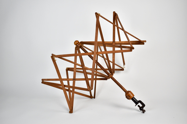
Functional object - Skein Holder, 1890-1900
Skein holder is from c1890-1900 and used by four generations of the donor's family who lived around Woori Yallock and Yellingbo. Donor's family descended from settler John Douthie (1831-1897), his son Andrew Douthie married Jessie Sands Smith (1875 - 1948). Item believed to have been owned by Jessie who passed it on to her fourth child, Mary, who passed it to her child Lillian who passed it to her daughter Leanne, the donor. No makers mark on item. Mary worked as a teacher and sewing mistress at Woori Yallock Primary School and used the item in her personal time to make clothing for the family.An umbrella-style wooden skein holder with a metal clamp at the base to allow it to attach to a table or similar. When not in use, item is small and compact, however once unfolded the arms extend out in an umbrella shape with thin timber rods bound together with leather ties. -
 Port Fairy Historical Society Museum and Archives
Container - Bag, school
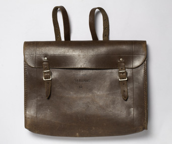
Schoolbag belonging to Joan Powling when she was a student at the Port Fairy Consolidated School in the 1960s.The school bag is typical of the bag that children would carry their school work, lunch bag to and from school in this period. It evokes memories of another time period and is culturally significant to the life of children who attended the Port Fairy Consolidated School. Brown solid leather school bag with 2 backstraps, 2 buckle fasteners.Solid leather 13. Joan Powling.school bag, joan powling, port fairy consolidated school -
 City of Greater Bendigo - Civic Collection
Flyer, Bolton Brothers Printers, J.H. Abbott & Co, c 1880
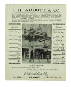
In 1867 J.H. Abbott established the New Times Boot Market & Factory in Pall Mall, Sandhurst. In 1867, his wife Anne took over running the shop which was located next to the Bendigo Arcade near Williamson Street and was successful in creating a successful business. In 1876, the leather business of T. Baulderstone was purchased, and operations were further expanded later by the acquisition of the Edinburgh Tannery at Sheepwash Creek, and The Edinburgh Leather & Grindery warehouse in Bull Street, Sandhurst. In 1889, Joseph Abbott passed all interests in the business to his son, who shared the same name, in partnership with an adopted son, Richard Hartley Smith Abbott. The business continued trading under the name J. H. Abbott & Co. A number of branches of the business had been established in the early 1900s. In 1959 the Pall Mall business relocated to 291 Hargreaves Street. The whole business was soon after consolidated and conducted from the Market Square branch (Lyttleton Terrace) as the Abbott Supply Company. Harold Abbott, the last of the family to work in the business, died in 1979. In 1980 the business shifted to a new purpose-built store and warehouse on the corner of Abel & Deborah Streets, Bendigo. Sandhurst Trustees administered the business from 1979 until its sale in 1986. He was elected to the Sandhurst Borough Council and in 1860 became chairman of the municipality.Two single colour printed gatefold flyer on green paper advertising J.H. Abbott and Co.'s boot and shoe store on Pall Mall Bendigo. Contains information on products and the fitting services provided in store for customers. chairman of sandhurst borough, anne abbott, city of greater bendigo commerce -
 Royal District Nursing Service (now known as Bolton Clarke)
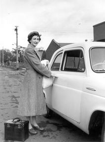
Photograph - Photograph, black and white:, 1952
This photograph depicts the style of MDNS uniform worn at that time, which was a grey cotton dress and red cardigan, over which was a woolen grey coat. The beret was of grey felt and had a red Maltese cross attached to the centre. Sister Wilson is about to enter her MDNS car, which was one of the early cars in the MDNS fleet, to drive to a patient to give nursing care.Royal District Nursing Service (RDNS) has had various modes of transport over the last 130 plus years. At first, from 1885 as Melbourne District Nursing Society (MDNS), their Trained nurses (Nurses) walked the streets and lane ways amid the slums of central Melbourne. As the Society expanded public transport was used, and bicycles were bought by the Society in 1903 and used in inner areas until 1945. During the Spanish flu epidemic, in 1919, MDNS appealed for assistance to procure Motor vehicles so the Nurses could visit an influx of cases. Through trusts, grants and donations four 'Ford T Model' cars were procured which enabled the Nurses to triple their visits. Through constant use the cars were in such a poor state they were sold in 1927. A Motor Auxiliary was formed in 1929 to take Sisters to patients, and some Sisters used their own cars; even a motorcycle was used by one Sister in 1933. All these forms of transport were intermingled and in the early 1950s, and now as Melbourne District Nursing Service, seven Ford Prefect cars were bought followed by twelve Ford Anglia cars 1955. Having received Royal patronage; the now Royal District Nursing Service (RDNS) had its own fleet of Holden vehicles by the mid 1960s and the Motor Auxiliary ceased operating in 1971 as by then all staff employed were required to have a driving licence. Seat-belts had been introduced to Victoria in 1959 and District fitted them to their cars from 1962, even though they did not become compulsory until 1970. The Holden vehicles were replaced with grey Holden Torana vehicles. After several years the fleet was changed to white Toyota Corolla vehicles. The Melways Directory of maps was introduced in 1966, which was a boon to the Sisters though it was a few years before it went beyond Seville, so a large paper map was used by the Sisters visiting patients in the areas passed Seville. By 2009 there were 598 cars in the fleet and the Sisters travelled 9 million 200,000 kilometres – this is equivalent to 12 trips to the moon and back. Black and white photograph of Sister Jill Wilson of the Melbourne District Nursing Society (MDNS) about to enter her work car. Sister Wilson is wearing her winter uniform, with a light grey beret over her short dark curled hair, and a long light grey coat which has lapels. She is standing side on, and to the left of the partially seen small white car. She is smiling and looking at the camera. Her right arm is extended with her hand on the handle of the partially opened car door and she is holding a white bag and cloth in her left hand. At her feet is her dark coloured, square shaped, nursing case which has a leather strap around the middle and two light coloured clasps each end, as well as a thick hard handle on the top. She is standing on the road and to her left, on the grass, are two lamp posts; small bushes can be seen as well as two trees in the distance. Two dark coloured buildings, one with a hip roof and one a flat roof, can be seen behind the car. rdns, motor vehicle, nurse, uniform, melbourne district nursing society, mdns, rdns transport, royal district nursing service, sister jill wilson -
 Trafalgar Holden Museum
Accessory - Belly Band
Single brown leather belt that was used as the belly belt on a working horse harness ca 1900Manufactured and sold by Holden and Frost Ca 1900Brown leather single leather belt with band hook each end, as part of the leading harness as used on work horsesbelly belt, harness, equine -
 Kilmore Historical Society
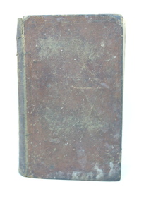
History of England, 1846
Whittaker's improved edition of Pinnock's Goldsmith's History of England, from the invasion of Julius Caesar to the death of George 11., with a continuation to the present time; also, a dictionary, biographical, historical &c. explaining every difficulty, and rendering the whole easy to be understood; and questions for examination at the end of each section: besides a variety of valuable information added throughout the work....Brown leather-bound hardcover book, very worn extremities, tear to upper spine. Embossed cross-hatch design on leather with embossed border. Staining lower right front, loss of colour back & front. Scored damage to front. Flyleaf torn with piece missing upper right. Front hinge separated, binding loose. 2nd flyleaf stained. Foxing and discolouration of page edges. 519 pp. Poor condition.Inside front cover, label advertising Fulton & Knight's Pronouncing Dictionary, 'T & C Buck/1846'. Front flyleaf, ' [missing] Buck/ [indecipherable] school/1846'. Front 2nd flyleaf, 'Thomas Buck/Mounted Constable/Kilmore District/June 1856'.history of england, thomas buck, mounted constable, kilmore -
 Parks Victoria - State Coal Mine - Wonthaggi
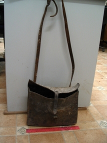
Bag /satchel, C 1900's
Nobby Smith's bag used when out riding his horse fixing fences. Made by Arthur Smales. Nobby Smith worked for almost 30 years at the SCM as a Stable Manager. "Come here! Gee off" Joe & Lyn Chambers December 1991Leather bag / satchel with flap and buckle, long shoulder strap. Side panel stiched with white stitching. -
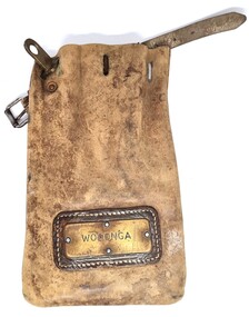 Wodonga & District Historical Society Inc
Functional object - Leather pouch and stamps - Cudgewa Railway Line
Cudgewa Line -The Cudgewa railway line opened in stages between 1889 and 1921. The first section from Wodonga to Huon opened on 10 September 1889. It was extended to Bolga on 18 July 1890, Tallangatta on 24 July 1891 and then to Shelley on 13 June 1916. Shelley was the highest station in Victoria. It extended further on to Beetomba on 10 April 1919 and finally reached Cudgewa on 5 May 1921. The line had 1 in 30 grades and trestle bridges that have been heritage listed. In 1919, the line was used to carry materials for the construction of Hume Weir, and three years later a spur line connecting Ebden to the weir was opened. In the 1960s, Cudgewa became the railhead of materials for the Snowy Mountains Scheme. The last passenger service from Wodonga to Tallangatta ran on 30 September 1961. The turntable and passenger platform at Cudgewa were abolished in 1976. These stamps were used by Joh Murray who for many years worked with Victorian Railways based at Wodonga.A leather pouch with belt and lock. It bears a metal name tag inscribed with name of railway station. The pouch contains 3 station stamps, a date stamp and 2 carriage keys.On pouch WODONGA On stamps: BONEGILLA 1470/ EBDEN 1471/ BANDOLIER 1473cudgewa rail line, victorian railways, closed victorian railways, railway stamps -
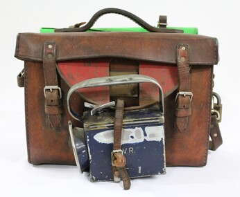 Wodonga & District Historical Society Inc
Functional object - Victorian Railways Guard's Satchel c. 1970s
The leather satchel with printed information and equipment including instruction manuals, report sheets, rubber stamps and books was issued to Barry Ryan when he started working as a guard for Victorian Railways in Wodonga in 1972. It was in use until he became a locomotive train driver in 1987, when guards no longer worked on the trains.The leather satchel has local significance as it was used by a guard on the Victorian Railways in Wodonga and the railway was an important factor in the development of Wodonga. It also has state significance as part of the Victorian railways equipment for train guards, and is representative given that it's a complete kit with the green signal flag, lamp and the instruction manuals, report sheets, rubber stamps and books in the satchel.Brown leather Victorian Railways guard's satchel, with a leather handle and shoulder strap. There is a rolled up green signal flag attached behind the handle on the top and a dark blue metal lamp attached to the front of the satchel. The lamp has a green filter in front of the bulb, so it would emit green light. The raised letters "V.R." are located on the front and top surfaces of the blue metal lamp, and the number "2749" is engraved on the back surface. The name "B. RYAN" is engraved in the front surface of the lamp. The number "2544' is stamped into a brass plate on the front of the satchel. There is a semi-circular red painted iron disk hinged to the front of leather satchel with a cut out area in the centre to show the number on the brass plate. The lamp is attached to lower rim of the semi-circular red painted iron disk. Inside the leather satchel there are instruction manuals, report sheets, rubber stamps and books relating to the work as a guard on the Victorian railways, as the satchel was used by the donor Barry Ryan when he started working as a guard for Victorian Railways in Wodonga in 1972. "V.R." in raised letters on the front and top surfaces of the metal torch. "B. RYAN" engraved in the front surface of the torch. "2749" engraved into the back surface of the metal torch. "2544" stamped into the surface of the brass plate on the front of the leather satchel. victorian railways, v.r., victorian trains, trains, train guards, leather satchel, satchel, wodonga -
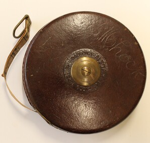 Wodonga & District Historical Society Inc
Functional object - Retractable wired measuring tape, John Rabone & Sons, 1939
Rabone & Sons had its origins in Birmingham, as rule and tool makers. The business was continued by John Rabone and his (John's) grandson, Eric Rabone. It worked under the name of John Rabone & Sons c1784-1953, becoming a public company in 1948. Control of the business remained with the Rabone family until 1962. In 1963 the company merged with a toolmaker from Sheffield to become Rabone Chesterman. The name E. M. Lock has been carved into the leather on one side. Edith May Lock was the mother of Arthur Lock who served in the 2/23 RD Australian Infantry Battalion, known as "Albury's Own".This item is part of a collection of items owned by Arthur Lock, a member of the 2/23rd Battalion, an all-volunteer Second Australian Imperial Force which served as part of the garrison during the Siege of Tobruk, then at El Alamein, New Guinea and Borneo. It has particular local significance as the battalion was know as "Albury's Own" because a large majority of the battalion's initial intake of volunteers came from the Albury–Wodonga region.A retractable wire measuring tape with leather casing and brass centre and winding handle. The tape is 66 feet in length. The manufacture's name, John Rabone & Sons, is inscribed around the centre circle as well as the Number 401 and 66FTAround centre circle "JOHN RABONE & SONS/BIRMINGHAM ENGLAND". In the centre "NO401 66FT" On opposite side around centre circle "RABONE'S METALLIC WIRED TAPE". Engraved into the surface "E.M.Lock"world war 11, john rabone and sons, wired measuring tape -
 Wodonga & District Historical Society Inc
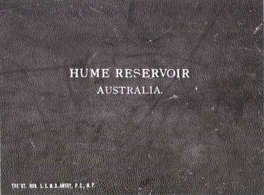
Album - Hume Reservoir Australia Album - Cover, Department of Public Works, N.S.W, 1927
This set of photos is from a leather bound album bearing the inscription "HUME RESERVOIR AUSTRALIA" plus 'The Rt. Hon. L. C. M. S. Amery, P. C., M .P.' all inscribed in gold. It was presented to The Rt. Hon. L. C. M. S. Amery, P. C., M. P, Secretary of State for Dominion Affairs on the occasion of his visit to the Hume Reservoir on 2nd November 1927. To ensure preservation of the album and its contents, the images and information pages have all been digitised. It is assumed that over the past 70 to 80 years there has been some loss of contrast due to fading, and probably detail. Thus, each photo was enhanced in several steps. Digitalisation of the album was completed by Eric Eulenstein in Wodonga in April 2002. The position of Secretary of State for Dominion Affairs was a British cabinet-level position created in 1925 and responsible for British relations with the Dominions — Canada, Australia, New Zealand, South Africa, Newfoundland, and the Irish Free State — and the self-governing Crown colony of Southern Rhodesia.This album is of local and national significance as it documents the planning and development of the Hume Reservoir up to 1927. It was the largest water reservoir in the British Empire. The album records the pioneering engineering work that went into its construction.Leather bound cover of the album of photos and information documenting the planning and development of the Hume Reservoir up to 1927. It was presented to The Rt. Hon. L.C.M.S. Amery, P.C., M.P, Secretary of State for Dominion Affairs on the occasion of his visit to the Hume Reservoir on 2nd November 1927. Embossed in gold in centre of cover "HUME RESERVOIR/AUSTRALIA" At bottom left "The Rt. Hon. L.C.M.S. Amery, P.C., M.P."hume reservoir australia, the rt. hon. l.c.m.s. amery -
 Wodonga & District Historical Society Inc
Album - Hume Reservoir Australia Album - Introduction - Part 1, Department of Public Works, N.S.W, 1927
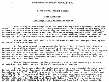
This set of photos is from a leather bound album bearing the inscription "HUME RESERVOIR AUSTRALIA" plus 'The Rt. Hon. L. C. M. S. Amery, P. C., M .P.' all inscribed in gold. It was presented to The Rt. Hon. L. C. M. S. Amery, P. C., M. P, Secretary of State for Dominion Affairs on the occasion of his visit to the Hume Reservoir on 2nd November 1927. This album is of local and national significance as it documents the planning and development of the Hume Reservoir up to 1927. It was the largest water reservoir in the British Empire. The album records the pioneering engineering work that went into its construction.RIVER MURRAY WATERS SCHEME, HUME RESERVOIR THE LARGEST IN THE BRITISH EMPIRE. ' The history of the inception of the River Murray Waters Agreement under the terms of which the Hume Reservoir is being constructed, the purposes of the work, its correlation to the other works on the Murray and the methods of construction are all outlined in the attached article entitled “The River Murray Waters Scheme, the Nile of Australia”, by Mr H.H. Dare, M.E., M.Inst.C.E., Commissioner, Water Conservation and Irrigation, and the New South Wales Representative on the River Murray Commission. The article was published in 1925 and some alterations brought about by the efflux of time are necessary. As far as personnel is concerned, the death of Mr J.S. Dethridge, M.Inst.C.E., removed a very able engineer from the councils of the Commission. His place as Representative of Victoria has been taken by Mr R. Horsfield. It is also to be regretted that ill-health has caused the retirement of Mr E.M. de Burgh, M.Inst.C.E., the eminent Chief Engineer for New South Wales, who, with Mr Dethridge, was largely responsible for the Agreement cemented by the River Murray Waters Acts and, inter alia, for the design of the Hume Dam. The following summary of the progress of work on the Locks might be substituted for the latter part of Mr Dare’s paragraph. Up to the present time six locks and weirs have been completed, the highest in the series being at Torrumberry and the lowest at Blanchetown. Locks No.26 at Torrumberry and No.11 at Mildura were built by Victoria and are in use. A lock and weir (No.10) is in progress at Wentworth, and the necessary camp arrangements, purchase of plant, etc., have been undertaken in connection with lock and weir No.15 at Euston, both under the direction of New South Wales. Lock No.9, which forms part of the Lake Victoria Scheme, Lock No.5 at Renmark and Lock No.3 in South Australia hume reservoir australia, river murray waters scheme -
 Wodonga & District Historical Society Inc
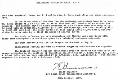
Album - Hume Reservoir Australia Album - Introduction - Part 2, Department of Public Works, N.S.W, 1927
This set of photos is from a leather bound album bearing the inscription "HUME RESERVOIR AUSTRALIA" plus 'The Rt. Hon. L. C. M. S. Amery, P. C., M .P.' all inscribed in gold. It was presented to The Rt. Hon. L. C. M. S. Amery, P. C., M. P, Secretary of State for Dominion Affairs on the occasion of his visit to the Hume Reservoir on 2nd November 1927. This album is of local and national significance as it documents the planning and development of the Hume Reservoir up to 1927. It was the largest water reservoir in the British Empire. The album records the pioneering engineering work that went into its construction.DEPARTMENT OF PUBLIC WORKS, N.S.W. (continued from previous image). have been completed, Locks Nos. 2, 4 and 6, also in South Australia, are under construction. In the description of the Hume Dam the following emendations have to be made. The total length will be 5,300 feet of which 4,258 feet will consist of an earthen embankment. The maximum depth of water conserved will be 24 feet more than originally intended with an additional allowance of 9 feet for surcharge, the total capacity will be 2,000,000 acre feet, the water surface at full supply level 44,000 acres, and provision is being made for a flood discharge of 182,000 cusecs. For handy reference, the main dimensions and figures and comparisons with other dams throughout the world are given in a tabulated statement attached. The Hume Reservoir will be the largest in the British Empire. Photographs showing the work at various stages of construction are appended. The Resident Engineer for New South Wales from the start of the work until his recent promotion to the position of Inspecting Engineer was Mr J. Keith Ross, M.A., B.Sc., A.M.Inst.C.E., who has been succeeded by Mr S.W. Jones, B.E., A.M.Inst.C.E. The Resident Engineer for Victoria is Mr A.W. Johnson, B.E. (Signed) M. Inst.C.E. Chief Engineer New South Wales Constructing Authority 27th October 1927. hume reservoir australia, river murray waters scheme -
 Wodonga & District Historical Society Inc
Album - Hume Reservoir Australia Album - Dimensions of Hume Reservoir, Department of Public Works, N.S.W, 1927
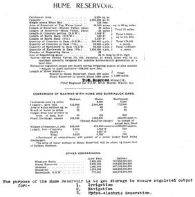
This set of photos is from a leather bound album bearing the inscription "HUME RESERVOIR AUSTRALIA" plus 'The Rt. Hon. L. C. M. S. Amery, P. C., M .P.' all inscribed in gold. It was presented to The Rt. Hon. L. C. M. S. Amery, P. C., M. P, Secretary of State for Dominion Affairs on the occasion of his visit to the Hume Reservoir on 2nd November 1927. This album is of local and national significance as it documents the planning and development of the Hume Reservoir up to 1927. It was the largest water reservoir in the British Empire. The album records the pioneering engineering work that went into its construction.Table outlining the Dimensions of the Hume Weir and comparisons with MAKWAR and BURRINJUCK DAMS, and some other comparisons. MAKWAR Dam is located on the Blue Nile about five miles south of Sennar and 175 miles south of Khartoum in Sudan. The construction of this dam started in 1922 and was completed in May 1925, while the British Empire colonised Sudan. It was officially opened on 21st January 1926. The BURRINJUCK DAM is situated in the upper catchment of the Murrumbidgee River, approximately 60 kms from Yass, N.S.W. It was built from 1907 to 1927 The stated purpose of the Hume Reservoir is to get storage to ensure regulated output for:- 1. Irrigation 2. Navigation 3. Hydro-electric Generation.hume reservoir australia, river murray waters scheme, hume dimensions -
 Wodonga & District Historical Society Inc
Album - Hume Reservoir Australia Album - Plans and Progress Photos - River Murray Water Scheme, Department of Public Works, N.S.W, 1927
This set of photos is from a leather bound album bearing the inscription "HUME RESERVOIR AUSTRALIA" plus 'The Rt. Hon. L. C. M. S. Amery, P. C., M .P.' all inscribed in gold. It was presented to The Rt. Hon. L. C. M. S. Amery, P. C., M. P, Secretary of State for Dominion Affairs on the occasion of his visit to the Hume Reservoir on 2nd November 1927. This album is of local and national significance as it documents the planning and development of the Hume Reservoir up to 1927. It was the largest water reservoir in the British Empire. The album records the pioneering engineering work that went into its construction.1. Locality Plan and Plan of Dam. The dam is about ten miles by road upstream from Albury and about three-quarters of a mile below the confluence of the Mitta Mitta River and the Murray River. Its main features consist of a concrete portion across the bed of the river with earth embankment at both ends. The foundations throughout are on hard granite, found at an average depth of about 40 feet below the surface, the centre line being located to take advantage of the most favourable rock levels.Heading on page "WORKS UNDER RIVER MURRAY WATERS AGREEMENT/HUME RESERVOIR" Beneath top diagram "FIG. 1. ELEVATION" Beneath second diagram "FIG. 2. PLAN" On map "LOCALITY PLAN"hume reservoir australia, river murray waters scheme, hume weir diagrams, hume weir location -
 Wodonga & District Historical Society Inc
Album - Hume Reservoir Australia Album - Detail plan and explanation, Department of Public Works, N.S.W, 1927
This set of photos is from a leather bound album bearing the inscription "HUME RESERVOIR AUSTRALIA" plus 'The Rt. Hon. L. C. M. S. Amery, P. C., M .P.' all inscribed in gold. It was presented to The Rt. Hon. L. C. M. S. Amery, P. C., M. P, Secretary of State for Dominion Affairs on the occasion of his visit to the Hume Reservoir on 2nd November 1927. This album is of local and national significance as it documents the planning and development of the Hume Reservoir up to 1927. It was the largest water reservoir in the British Empire. The album records the pioneering engineering work that went into its construction.2. Detail Plan and Section. Starting from the New South Wales and there will be an earthen embankment 430 feet 6 inches long which is retained by the North Wing Wall. Then come the sluice section 284 feet 3 inches long, the spillway 720 feet long and the South Wing Wall, making a total length of 1,042 feet 6 inches of concrete wall. Beyond the South Wing Wall is earth embankment again to a length of 3,827 feet. The Full Supply Level is R.L.626.00 and allowance has been made for a surcharge of 9 feet. A road will run along the top of the dam at R.L.642.00. The sluice section contains seven offlets, the three nearest the north wing wall being 13 feet in diameter for hydro-electric purposes and the other four 9 feet in diameter for regulation purposes only. There are to be stony sluice gates on the upstream ends of the outlets and needle valves on the downstream ends. The shock of the discharged water will be taken by a stilling pool. Trash racks will protect the intake ends of the outlets. Next comes the spillway section, which is curved on the downstream face, and carried up to within 15 feet of the full supply level. Above that will be a series of piers between which will be the flood gates and on top of which the roadway will be carried. The gates will be 20 feet wide and 15 feet high and will be 29 in number. They will slide down the face of the wall when opened for the escape of the water. The investigation of the control of this cascade of water was made by means of a model and as a result the form of “bucket” or energy dissipater shown on the section of the spillway was decided upon. The earth embankment in Victoria is being constructed by the State Rivers and Water Supply Commission of Victoria who are the Constructing Authority for that State under the River Murray Waters Agreement. The core of the embankment is of concrete 6 feet wide at the base tapering to 2 feet at the top end and is reinforced with steel rods from the level of the decomposed rock upwards. On the downstream side, at about natural surface level, is a tunnel for drainage and inspection purposes. Above the tunnel is a vertical layer of large stones to drain any seepage to the tunnel. Against the core wall is packed selected material of as impervious a character as can be got locally and beyond that the bank is carefully built up in horizontal layers by means of horses and wheel scoops. The upstream slope is 3-to-1 hardening to 2½-to-1 at the top and the downstream slope is 2½-to-1 hardening to 2.07-to-1 at the top. The thrust of the upstream toe is taken by a mass of granite blocks, and this face is protected by concrete laid in situ. The width of the bank at base is 650 feet and at top 32 feet.hume reservoir australia, river murray waters scheme, hume weir diagrams, hume plan details -
 Wodonga & District Historical Society Inc
Album - Hume Reservoir Australia Album - Hume Reservoir Detailed diagrams, Department of Public Works, N.S.W, 1927
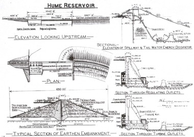
This set of photos is from a leather bound album bearing the inscription "HUME RESERVOIR AUSTRALIA" plus 'The Rt. Hon. L. C. M. S. Amery, P. C., M .P.' all inscribed in gold. It was presented to The Rt. Hon. L. C. M. S. Amery, P. C., M. P, Secretary of State for Dominion Affairs on the occasion of his visit to the Hume Reservoir on 2nd November 1927. This album is of local and national significance as it documents the planning and development of the Hume Reservoir up to 1927. It was the largest water reservoir in the British Empire. The album records the pioneering engineering work that went into its construction.6 Diagrams showing the details of the Hume Reservoir structure. On the left from the top of the page to bottom are:- ELEVATION LOOKING UPSTREAM, PLAN aTYPICAL SECTION OF EARTHEN EMBANKMENT. ' On the right from top to bottom are:- SECTIONAL - ELEVATION OF SPILLWAY & TAIL WATER ENERGY DISSIPATOR, SECTION THROUGH REGULATING OUTLETS and SECTION THROUGH TURBINE OUTLETS.hume reservoir australia, river murray waters scheme, hume weir diagrams, hume plan details -
 Wodonga & District Historical Society Inc
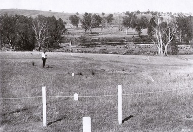
Album - Hume Reservoir Australia Album - View of site on 28th November 1919
This set of photos is from a leather bound album bearing the inscription "HUME RESERVOIR AUSTRALIA" plus 'The Rt. Hon. L. C. M. S. Amery, P. C., M .P.' all inscribed in gold. It was presented to The Rt. Hon. L. C. M. S. Amery, P. C., M. P, Secretary of State for Dominion Affairs on the occasion of his visit to the Hume Reservoir on 2nd November 1927. This album is of local and national significance as it documents the planning and development of the Hume Reservoir up to 1927. It was the largest water reservoir in the British Empire. The album records the pioneering engineering work that went into its construction.DEPARTMENT OF PUBLIC WORKS, N.S.W. RIVER MURRAY WATERS SCHEME. HUME RESERVOIR. 3. View of site on 28th November 1919 when the first sod was turned by the Governor General Sir Ronald Munro Ferguson, now Lord Hovar. The view is taken from the New South Wales end of the dam looking across the Murray to Victoria. The Murray flows from left to right.hume reservoir australia, river murray waters scheme, hume weir diagrams, hume plan details -
 Wodonga & District Historical Society Inc
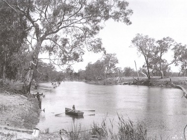
Album - Hume Reservoir Australia Album - The River Murray at the site of the dam 28th November, 1919
This set of photos is from a leather bound album bearing the inscription "HUME RESERVOIR AUSTRALIA" plus 'The Rt. Hon. L. C. M. S. Amery, P. C., M .P.' all inscribed in gold. It was presented to The Rt. Hon. L. C. M. S. Amery, P. C., M. P, Secretary of State for Dominion Affairs on the occasion of his visit to the Hume Reservoir on 2nd November 1927. This album is of local and national significance as it documents the planning and development of the Hume Reservoir up to 1927. It was the largest water reservoir in the British Empire. The album records the pioneering engineering work that went into its construction.DEPARTMENT OF PUBLIC WORKS, N.S.W. RIVER MURRAY WATERS SCHEME. HUME RESERVOIR. The River Murray at the site of the dam on 28th November 1919 looking upstream. hume reservoir australia, river murray waters scheme, hume weir diagrams, hume plan details -
 Wodonga & District Historical Society Inc
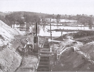
Album - Hume Reservoir Australia Album - Foundations for core wall of earth embankment, September 1921
This set of photos is from a leather bound album bearing the inscription "HUME RESERVOIR AUSTRALIA" plus 'The Rt. Hon. L. C. M. S. Amery, P. C., M .P.' all inscribed in gold. It was presented to The Rt. Hon. L. C. M. S. Amery, P. C., M. P, Secretary of State for Dominion Affairs on the occasion of his visit to the Hume Reservoir on 2nd November 1927. This album is of local and national significance as it documents the planning and development of the Hume Reservoir up to 1927. It was the largest water reservoir in the British Empire. The album records the pioneering engineering work that went into its construction.DEPARTMENT OF PUBLIC WORKS, N.S.W. RIVER MURRAY WATERS SCHEME. HUME RESERVOIR. 5. Foundations for core wall of earth embankment in New South Wales in September 1921. The River Murray in flood.hume reservoir australia, river murray waters scheme, hume weir diagrams, hume plan details -
 Wodonga & District Historical Society Inc
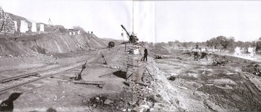
Album - Hume Reservoir Australia Album - Excavations for foundations of spillway, September 1921
This set of photos is from a leather bound album bearing the inscription "HUME RESERVOIR AUSTRALIA" plus 'The Rt. Hon. L. C. M. S. Amery, P. C., M .P.' all inscribed in gold. It was presented to The Rt. Hon. L. C. M. S. Amery, P. C., M. P, Secretary of State for Dominion Affairs on the occasion of his visit to the Hume Reservoir on 2nd November 1927. This album is of local and national significance as it documents the planning and development of the Hume Reservoir up to 1927. It was the largest water reservoir in the British Empire. The album records the pioneering engineering work that went into its construction.DEPARTMENT OF PUBLIC WORKS, N.S.W. RIVER MURRAY WATERS SCHEME. HUME RESERVOIR. 6. Excavation in progress for foundations of outlet and spillway sections of dam. September 1921.hume reservoir australia, river murray waters scheme, hume weir diagrams, hume plan details