Showing 864 items
matching national park
-
 Stawell Historical Society Inc
Book, Stawell & Grampians Tourist Council, Stawell & Grampians Visitor Guide & Directory 1989, 1989
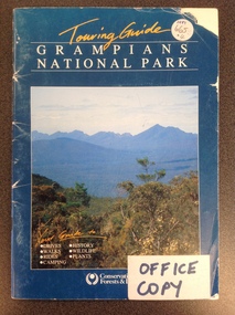
... "Grampians National Park" Bottom left of photo In Yellow script...." white Print "Grampians National Park" Bottom left of photo ...Blue cover Title above photo of colour photo of the Grampains, writing on photo in bottom left. White sticker with blue print bottom right. Rear cover contains a centered photo of a rocky outcrop and trees.Yellow Semi-cursive script. "Touring Guide." white Print "Grampians National Park" Bottom left of photo In Yellow script "Your Guide To" guide to underlined. Bottom right on white sticker in blue Print "OFFICE COPY"stawell tourism -
 University of Melbourne, Burnley Campus Archives
Booklet, Australian National Parks and Wildlife Service et al, Conservation of Insects and Related Wildlife, 1988
... National Parks and Wildlife Service survey of insect conservation... booklet. Report on the Australian National Parks and Wildlife ...conservation, insects, wildlife, national parks and wildlife service, entomology -
 Wangaratta Urban Fire Brigade
frame picture
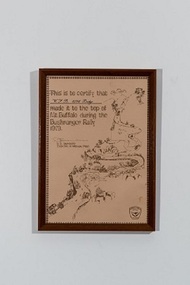
... by D.S Saunders Director of National Parks (top right quarter... Director of National Parks (top right quarter) (illustration ...Certificate that the Wang urban fire brigade 'dodge' made it to the top of Mt Buffalo in 1978simple brown frame with a certificate This is to certify that the 'W. F. B 1938 Dodge' made it to the top of Mt Buffalo during the Bushranger rally 1979. signed by D.S Saunders Director of National Parks (top right quarter) (illustration of winding road over the other 3/4) 1978, dodge -
 Federation University Historical Collection
Photograph, Mallee Fowl Mounds, Little Desert
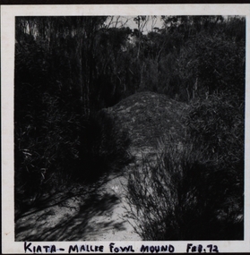
... A visit in 1972 to the Little Desert National Park... in 1972 to the Little Desert National Park by a group from Murtoa ...A visit in 1972 to the Little Desert National Park by a group from Murtoa headed by ranger K Hateley to observe mallee fowls' mounds.Black and white photograph of a mallee fowl mound at Kiata..1 Front ; Kiata - Mallee Fowl mound Feb. 72 Verso: Little Desert .2 Front: Mallee Fowl incubator mound - Little Desert verso: Little Desert 1972 .3 Practise Mound Mallee Fowl 72 Verso: Little Desert Feb 1972 .4 Verso: Visited Mallee Hen Nest: Jack Watson, Herbert Smith, Lance Yung, H Hately - Ranger Kiata .5 Rev. H Smith K Hatelley Kiata L.D. Verso:Mallee Fowl Mounds Little Desert Feb 1972 Agfa -4.2.72 .6 Dad Lance Bert Smith K Hateley Verso: John R Watson Lance Yung (brother -in-law of John (Jack)) Bert Smith, (uncle of Lance ) Feb1972 Little Desertmallee fowls, mallee fowls mounds, mallee fowl incubator mounds, k hateley, john r watson, lance yung, herbert smith, bert smith, jack watson -
 Eltham District Historical Society Inc
Newsletter, Newsletter, No. 1, May 1978
... to Eltham’ • Kinglake National Park ... to Eltham’ • Kinglake National Park The Shire of Eltham Historical ...Contents: • Newsletter format • May meeting • Office Bearers 1978 • Subscriptions • Community Centre opening • ‘Back to Eltham’ • Kinglake National Park The Shire of Eltham Historical Society was formed in October 1967. The first newsletter of the Society was issued May 1978 and has been published continuously ever since on a bi-monthly basis. With the cessation of the Shire of Eltham in late 1994, the Society's name was revised to Eltham District Historical Society and this name first appeared with issue No. 103, July 1995. The collection of the Society's newsletters provides a valuable resource on the history of the Society's activities, office bearers and committee members, guest speakers and subjects of historical interest pertinent to the former Shire of Eltham and the Eltham District.A4 photocopied newsletter distributed to membersnewsletter, eltham district historical society, shire of eltham historical society -
 Stawell Historical Society Inc
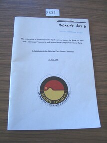
Book, Koorie Tourism Unit, A Submission to Victorian Place Names Committee 24 May 1990, 1990
... National Park Underlined: A Submission to the Victorian Palce Names... Grampians National Park Underlined: A Submission to the Victorian ...White card with black print and yellow, black and red circle with yellow and white printThe restoration of Jardwadjali and Djab warruning names for Rock Arts Sites and Landscape Features in and around Grampians National Park Underlined: A Submission to the Victorian Palce Names Committee 24 May 1990 Yellow Print: Koorie Tourism Black Print: Victorian Tourism Commissionstawell -
Stawell Historical Society Inc
Book, I.R. McCann, Grampians Wildflowers An Illustrated Checklist - Volume 1 & 2, 1984
... dicotyledonous plants which have been recorded in the Grampians National... dicotyledonous plants which have been recorded in the Grampians National ...This checklist contains 545 species of native dicotyledonous plants which have been recorded in the Grampians National Park, has been compiled from records made and lists assembled by A.C. Beauglehole O.A.M.Colour Photograph of Common Heath Flower, with Grey Insert with green and White Print. Another grey Insert Lower Right Coner with white printOn Cover: Grampians wildflowers An Illustrated Checklist - Volume 1 I.R. McCannstawell, grampians, flora -
 Kiewa Valley Historical Society
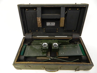
Stereoscope
... by National Parks Victoria located at Mt Beauty to look at aerial... photography and the landscape. It was used by National Parks Victoria ...The stereoscope was an interpretation device used to interpret aerial photography and the landscape. It was used by National Parks Victoria located at Mt Beauty to look at aerial photos so that they showed up the relief of the topography and therefore looked 3D.Used by National Parks Victoria staff located at the Mt Beauty office during the 1970's and early 1980's.Dark green wooden box with padded protection around the perimeter and on lid where 2 rectangular pieces of wood touch the stereoscope. The box is fitted with wooden dividers that fit around the stereoscope. The stereoscope is green metal with folding legs and sides attached to allow the stereoscope to sit on a surface. The instrument has 2 round glass ('mirrored viewing lens') cylinders eye distance apart, that allow light in from the side swinging doors. The amount of light is constricted by a rectangular piece of metal at the top of each leg. The box has swing clips used to close it and a metal swing handle all on the front side.The hinges are reinforced (and offer protection) by additional rubber pieces at each end. Inside the box is a brush made of bristle with a wooden handle - used for cleaning.Outside and top of box: written in black: No. 1026. On blue tape beneath: Mirror stereoscope 1026. written in black centre top of box: W10/WKA.0233. On front edge of box written in black: W10/WKA 0233. Inside box lid on silver plaque: Stereoscope Universal/ Made in / Australia / Die Casters Ltd. Victorianational parks victoria. stereoscope. aerial photographs. scientific instrument. mt beauty. 3d -
 Bendigo Historical Society Inc.
Photograph - PETER ELLIS COLLECTION: PETER ELLIS AND OTHERS, 23rd January, 1973
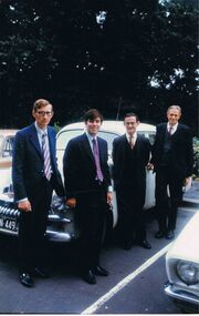
... (Hamer) 1973 Jan 23rd to get the Whipstick made into a National... into a National Park, Ultimately which was granted. Photograph PETER ELLIS ...Colour photograph. 4 men in suit and ties standing in front of Car in parking lot. Back of photo reads: Jan 23 1973 Robin Moors Peter Ellis Frank Robbins John Kellam Deputation to Premier of Victoria RJ Hamer re Whipstick. (Also on Pink sticky note attached to back of photo) Deputation to the Premier (Hamer) 1973 Jan 23rd to get the Whipstick made into a National Park, Ultimately which was granted.photo, group, male -
 Kew Historical Society Inc
Programme, Kew Canoe Carnival, 1939
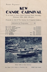
... to be held at Yarra Bend National Park on Saturday February 18th... Carnival to be held at Yarra Bend National Park on Saturday ...An item from an outstanding and diverse photographic collection, assembled by members of the Christian and Washfold families of Kew.10-page souvenir programme for the Kew Canoe Carnival to be held at Yarra Bend National Park on Saturday February 18th, 1939. Proceeds were designed to assist the Victorian Society for Crippled Children. Front cover shows photograph taken at the previous year's carnival. The site of the carnival shown on an internal map was upriver from Macauley's boat house. Photograph on back cover shows canoeists at Kew Boat Sheds, 45 Molesworth Street.kew canoe carnivals, recreation -- river yarra, christian-washfold collection -
 Victorian Aboriginal Corporation for Languages
Book, Sue Hodges, A bibliography of oral histories on the Australian Alps, 1996
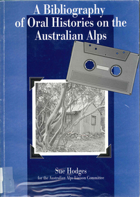
... , Siobhan McHugh collection, National Parks and Wildlife Service... collection, National Parks and Wildlife Service collection ...Covers 465 oral history interviews contained in a number of collections: - Kosciusko Huts Committee collection, Matthew Higgins collection, Peter Read collection, Ruth Lane collection, Sue Hodges collection, Tor and Jane Holth collection, Klaus Hueneke collection, Siobhan McHugh collection, National Parks and Wildlife Service collection, Stockman's Hall of Fame collection, Timothy Lee collection, Lesley Alves collection, Sue Wesson collection, unavailable collections.b&w photographs, tableshistoriography, australian alps history, victorian history -
 Orbost & District Historical Society
maagazine, Wild Life, July 1951
... and the need for proper management of national parks. Its editor... and the need for proper management of national parks. Its editor ...This magazine promotes the protection of wildlife and the need for proper management of national parks. Its editor Crosbie Morrison lobbied for a National Parks Authority which was finally set up under Morrison's directorship in 1957. During the 1940's and 1950's Crosbie Morrison (1900 - 1958) became Australia's best known naturalist. As a journalist with commercial radio and the Australian Broadcasting Commission, he made regular national nature study broadcasts to schools and other radio listeners for 20 years. He was the editor of Wild Life, a magazine which fostered interest in Australia's natural history and conservation, from 1938-54. (ref. CHAH web-site)This magazine reflects the work and legacy of Crosbie Morrison who campaigned for Victoria's national park system.A 100 pp magazine, covers missing, with b/ w photographs and articles on wildlife. It was intended for campers and those interested in nature. This is Volume 14 No 1.stamp of High School Orbostmagazine-wildlife morrison-crosbie natural-science -
 Orbost & District Historical Society
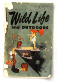
magazine, Wild Life, April 1953
... and the need for proper management of national parks. Its editor... and the need for proper management of national parks. Its editor ...This magazine promotes the protection of wildlife and the need for proper management of national parks. Its editor Crosbie Morrison lobbied for a National Parks Authority which was finally set up under Morrison's directorship in 1957. During the 1940's and 1950's Crosbie Morrison (1900 - 1958) became Australia's best known naturalist. As a journalist with commercial radio and the Australian Broadcasting Commission, he made regular national nature study broadcasts to schools and other radio listeners for 20 years. He was the editor of Wild Life, a magazine which fostered interest in Australia's natural history and conservation, from 1938-54. (ref. CHAH web-site) This magazine reflects the work and legacy of Crosbie Morrison who campaigned for Victoria's national park system.A 398 pp soft covered magazine with green covers. The title "WILD LIFE and OUTDOORS" is in black print.Below this is a coloured drawing of two women camping on the edge of a cliff. One is hanging on to the edge looking at a bird's nest. The magazine contains articles and photographs in black / white print.on front cover - "M. Gilbert' in red penmagazine-wild-life morrison-crosbie natural-history natural-science -
 Orbost & District Historical Society
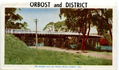
postcard series, 1960s
... and facilities. It was the major town close to several national parks... and facilities. It was the major town close to several national parks ...Included are photographs of the Orbost township, the Snowy River at Marlo, Gypsy Point, Buchan Caves and Bairnsdale. In the 1960s Orbost had a population of 4000 and was a major tourist attraction in Eastern Victoria with sufficient accommodation and facilities. It was the major town close to several national parks with access to either the surf or the snow. These postcards are pictorial records of Orbost in the 1960s. Postcards are very interesting records of places. architecture and transport.A colour postcard series with photographs of Orbost and the district. The cover photograph is of the Snowy River Bridge. There is an information card.Each photograph is labelled. at the bottom.postcards-orbost postcards-east-gippsland -
 Eltham District Historical Society Inc
Newsletter, Newsletter, No. 31 July 1983
... School – 125th Anniversary • Kinglake National Park • New... School – 125th Anniversary • Kinglake National Park • New ...Contents: • Next meeting guest speaker, Jack McLean: The Hurstbridge Line; a brief history • Falkiner Cottage, Ely Street, Eltham • Subscriptions • Hurstbridge Bank Building • St Andrews School – 125th Anniversary • Kinglake National Park • New Committee member • “Donald Thomson in Arnhem Land” The Shire of Eltham Historical Society was formed in October 1967. The first newsletter of the Society was issued May 1978 and has been published continuously ever since on a bi-monthly basis. With the cessation of the Shire of Eltham in late 1994, the Society's name was revised to Eltham District Historical Society and this name first appeared with issue No. 103, July 1995. The collection of the Society's newsletters provides a valuable resource on the history of the Society's activities, office bearers and committee members, guest speakers and subjects of historical interest pertinent to the former Shire of Eltham and the Eltham District.A4 photocopied newsletter distributed to membersnewsletter, eltham district historical society, shire of eltham historical society -
 Southern Sherbrooke Historical Society Inc.
Postcard - At The Kiosk, Ferntree Gully, Vic
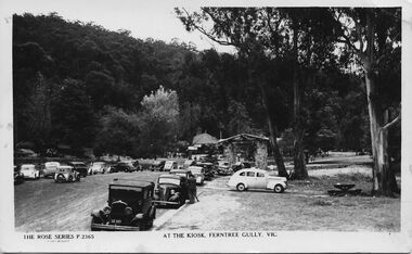
... outside the kiosk in what is now Ferntree Gully National Park... the kiosk in what is now Ferntree Gully National Park Several people ...B&W postcard, Rose Series P.2365, named 'At The Kiosk, Ferntree Gully, Vic.' Photo shows around twenty or more cars parked outside the kiosk in what is now Ferntree Gully National Park Several people are walking and standing in the carpark and on the paths. The kiosk is visible in the background with advertising signs outside, including one for Peters Ice-cream. Closer to the camera is a stone shelter. There are tall trees beside the carpark and in the background of the photo is a heavily treed hillside. The back of the postcard is blank. -
 Orbost & District Historical Society
framed photo, APFA- Davisigns (PG & ME Davis)
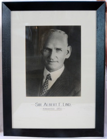
... parks east of Orbost were named the Albert and the Lind national... parks east of Orbost were named the Albert and the Lind national ...This photo was inherited with the building when the museum was established. Lind was born in 1878 in East Charlton, Victoria, the son of Oliver Nicholas Lind, a farmer from Denmark, and his Welsh wife Mary Ann Clay. In 1882, drought forced the family to move to East Gippsland where Lind was educated at Lucknow, and then to Bairnsdale in 1884 where he attended Bairnsdale state school. In October 1920, he was elected to the Victorian Legislative Assembly for the seat of Gippsland East for the Victorian Farmers' Union. Lind was made Minister of Forests, President of the Board of Land and Works and Commissioner of Crown Lands and Survey in Albert Dunstan's cabinet. He was knighted in 1951. In 1926 two national parks east of Orbost were named the Albert and the Lind national parks after him.A framed photo of Sir Albert Eli Lind. It is a black and white head and shoulders photo in a black wooden frame.Sir Albert E. Lind Knighted !951photograph politician lind-albert government -
 Hume City Civic Collection
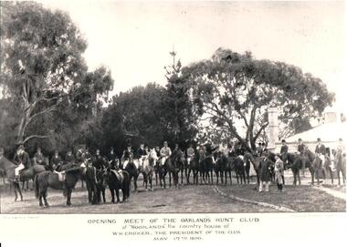
Photograph, 17 May 1890
... and the National Parks Service.... and the National Parks Service. oaklands hunt club national parks house ...The photograph was taken by Paul and Gerald Turner, formerly of Fitzroy Street, St. Kilda. It was taken to record the opening meeting of the 1890 season on 17 May. Members met at 'Woodlands', the country house of W. H. Crocker, who was the club president. The photo was supplied courtesy of Oaklands Hunt Club and the National Parks Service.A black and white photograph of the opening of the Oaklands Hunt Club. Most of the riders are mounted on horses which are standing in front of the picket fence, in a semi-circle. Four other men are standing in the foreground.OPENING MEET OF THE OAKLANDS HUNT / at 'WOODLANDS' the country house of / W.H. CROCKER, THE PRESIDENT OF THE CLUB / MAY 17th 1890oaklands hunt club, national parks, house names, horses, 1890s, crocker, w. h., turner, paul, gerald, photographers, woodlands, men, clothing and dress, george evans collection -
 Greensborough Historical Society
Book, Nillumbik Shire Council, 1997 Community Guide Nillumbik, 1997_
... like Kinglake National Park and Sugarloaf Reservoir... National Park and Sugarloaf Reservoir Annual guide to services ...Guide to services provided by Nillumbik Shire Council. Nillumbik Shire is located 25 kilometres north-east of Melbourne and the southern boundary is the Yarra River. The south of Nillumbik is predominantly urban, with commercial centres at Eltham and Diamond Creek. The north of the municipality includes significant natural features like Kinglake National Park and Sugarloaf ReservoirAnnual guide to services in Nillumbik. 64 pages. Cover is pale yellow with colour drawings. nillumbik shire council, handbooks -
 Greensborough Historical Society
Book, Nillumbik Shire Council, 1998 Community Guide Nillumbik, 1998_
... like Kinglake National Park and Sugarloaf Reservoir... National Park and Sugarloaf Reservoir Annual guide to services ...Guide to services provided by Nillumbik Shire Council. Nillumbik Shire is located 25 kilometres north-east of Melbourne and the southern boundary is the Yarra River. The south of Nillumbik is predominantly urban, with commercial centres at Eltham and Diamond Creek. The north of the municipality includes significant natural features like Kinglake National Park and Sugarloaf ReservoirAnnual guide to services in Nillumbik 72 pages. Cover has white background and some 3-D artwork.nillumbik shire council, handbooks -
 Greensborough Historical Society
Book, Nillumbik Shire Council, 1999 Community Guide Nillumbik, 1999_
... like Kinglake National Park and Sugarloaf Reservoir... National Park and Sugarloaf Reservoir Annual guide to services ...Guide to services provided by Nillumbik Shire Council. Nillumbik Shire is located 25 kilometres north-east of Melbourne and the southern boundary is the Yarra River. The south of Nillumbik is predominantly urban, with commercial centres at Eltham and Diamond Creek. The north of the municipality includes significant natural features like Kinglake National Park and Sugarloaf ReservoirAnnual guide to services in Nillumbik76 pages, illus. Cover has photographs of local people and title in white on orange background.nillumbik shire council, handbooks -
 Greensborough Historical Society
Book, Nillumbik Shire Council, Nillumbik Community Guide 2000/2001, 2000-2001
... like Kinglake National Park and Sugarloaf Reservoir... National Park and Sugarloaf Reservoir Annual guide to services ...Guide to services provided by Nillumbik Shire Council. Nillumbik Shire is located 25 kilometres north-east of Melbourne and the southern boundary is the Yarra River. The south of Nillumbik is predominantly urban, with commercial centres at Eltham and Diamond Creek. The north of the municipality includes significant natural features like Kinglake National Park and Sugarloaf ReservoirAnnual guide to services in Nillumbik76 pages, black and white illustrations. Cover has a collage of local children with title in white on mid-blue background.nillumbik shire council, handbooks -
 Nillumbik Shire Council
Painting: Kevin CHIN, Kevin Chin, Castle Under the Sky, 2018
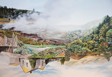
... at Yellowstone National Park, shortly after Trump’s election. In America... by a US studio residency at Yellowstone National Park, shortly ...This painting was sparked by a US studio residency at Yellowstone National Park, shortly after Trump’s election. In America, Chin witnessed conservative nationalism and divisiveness, but also an equal reaction promoting diversity and challenging structural inequality. Developing this work in Australia, Chin examined how a sense of place forms fluidly in the consciousness, to surpass geographic borderlines.Kevin Chin is a local artist. He has been a finalist in the Nillumbik Prize for Contemporary Art (2015, 2019). In this painting Chin explores economic, cultural and social structures that shape the world in which we live, questioning who has built what, who takes ownership, and who has the right to the land. Landscape painting depicting a house (upside down) and a half finished urban structure sitting amongst mountain peaks and land that has been cleared and immersed in fog/smoke.N/Alandscape, kevin, chin, structural, inequality, castle, trump, painting, nillumbik, residency, yellowstone, realism, oils -
 Hume City Civic Collection
Photograph
... government and placed under the management of the National Park... government and placed under the management of the National Park ...Woodlands Homestead was erected by William Greene in 1843 and is one of the state's oldest buildings. Over the years the complex has been renovated and extended. The property has connections with the racing industry over the years along with the neighbouring properties of 'Cumberland' and 'Attwood'. In 1978 654 acres of the original property was purchased by the state government and placed under the management of the National Park Service.A black and white photograph of part of a building showing the verandah with a paved floor. The hipped roof is covered with corrugated iron and the walls are weatherboard. An old steel kitchen chair is on the LHS at the end of the verandah and asparagus fern is growing up over the rear wall.woodlands homestead, greene, william pomeroy, anne, woodlands park, gellibrand hill, george evans collection -
 Melbourne Tram Museum
Postcard, Rose Stereograph Co, "Flinders St Railway station Melbourne", c1930's
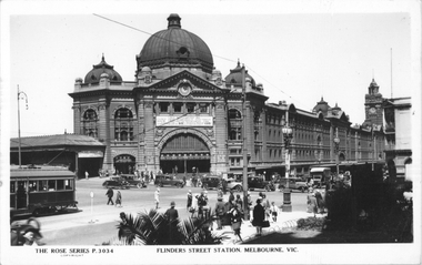
... National Park.... a large sign advertising Springtime at Mt Buffalo National Park ...Rose Series postcard No. P 3034 titled "Flinders St Railway station Melbourne" - with a W2 class tram about to cross Swanston Street. Some motor cars are in the view, some waiting to do their hook turns. A Policeman on point duty can be seen. The station has a large sign advertising Springtime at Mt Buffalo National Park.Yields information about the intersection of Flinders and Swanston Sts.Postcard - printed real photograph with Rose Stereograph Co. name on the rear.trams, tramways, w2 class, flinders st station, flinders st, swanston st -
 Warrnambool and District Historical Society Inc.
Document, Newspaper: Warrnambool Standard Christmas 1989, 1989
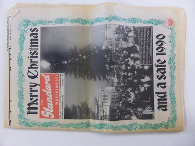
... Pertobe playground, local national parks, The film Quigley Down... playground, local national parks, The film Quigley Down Under ...This newspaper holds a collection of usual articles from local and national news,sports news to letters to the editor, advertisements and a supplement on activities for the holiday period. It contains the local advertisements for houses. The Holiday Guide section has articles on the Moscow Circus, Robert Ullmann, Lake Pertobe playground, local national parks, The film Quigley Down Under and points of interest along the coast. An interesting walk back through time and an interesting record of events and advertisements for businesses at the time.Front page has green holly border with photograph of Carols by Candlelight on the Civic Green. Banner headlines are in black.Back cover has a Christmas poem printed in black on pink background. Green holly border.44 pagesSaturday December 23 1989.warrnambool,, warrnambool standard, warrnambool standard december 1989 -
 Eltham District Historical Society Inc
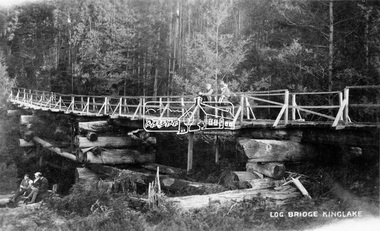
Negative - Photograph, Log bridge over Pheasant Creek, Kinglake, c.1920
... Postcard view of pedestrian log bridge in Kinglake National... National Park. The log bridge over Johnston's Creek is said to have ...Postcard view of pedestrian log bridge in Kinglake National Park. The log bridge over Johnston's Creek is said to have been built to allow the timber tramline to cross the creek. The bridge was destroyed in the 1926 bushfires. Other sources describe this bridge being located at Pheasant Creek (between Kinglake West and Kinglake Central) and that it was built by Mr Munro, the owner of the sawmill.This photo forms part of a collection of photographs gathered by the Shire of Eltham for their centenary project book,"Pioneers and Painters: 100 years of the Shire of Eltham" by Alan Marshall (1971). The collection of over 500 images is held in partnership between Eltham District Historical Society and Yarra Plenty Regional Library (Eltham Library) and is now formally known as 'The Shire of Eltham Pioneers Photograph Collection.' It is significant in being the first community sourced collection representing the places and people of the Shire's first one hundred years.Digital image 4 x 5 inch B&W Neg 1 printshire of eltham pioneers photograph collection, kinglake, log bridge, bridge, mr. munro, timber tramway, pheasant creek -
 Federation University Historical Collection
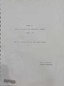
Booklet, Report of Natural Resources and Operations 1 Seminar April, 1983, 1983
... and Werribee Gorge National Park.... Gorge National Park. natural resources seminar school of mines ...This report details the program of a Natural Resources and Operations Seminar for the Victorian T.A.F.E. Off-Campus Network, hosted by the Victorian School of Forestry in Creswick. Thirty-one participants were in attendance. The program was conducted from the 6th to the 8th of April, 1983 and excursions were made to the You Yangs Forest Park, the Serendip Wildlife Research Station and Werribee Gorge National Park.A ring bound booklet of 19 pages and clear laminate covers. Includes a map of the Victorian School of Forestry, Creswick.natural resources, seminar, school of mines ballarat, ballarat school of mines, victorian t.a.f.e off-campus network, school of forestry, creswick, victorian school of forestry -
 Eltham District Historical Society Inc
Newsletter, Newsletter, No. 4, November 1978
... • Kinglake National Park • Kangaroo Ground School • Pioneers... • Kinglake National Park • Kangaroo Ground School • Pioneers ...Contents: • Next meeting • Other coming events o Eltham Living Forum o Historical Exhibition o Smiths Gully Excursion o Committee meeting o Next year • Early Eltham house, Ely Street • Kinglake National Park • Kangaroo Ground School • Pioneers and Painters • Railway Trestle Bridge, Eltham • Local History Series • Yemmerrawannie The Shire of Eltham Historical Society was formed in October 1967. The first newsletter of the Society was issued May 1978 and has been published continuously ever since on a bi-monthly basis. With the cessation of the Shire of Eltham in late 1994, the Society's name was revised to Eltham District Historical Society and this name first appeared with issue No. 103, July 1995. The collection of the Society's newsletters provides a valuable resource on the history of the Society's activities, office bearers and committee members, guest speakers and subjects of historical interest pertinent to the former Shire of Eltham and the Eltham District.A4 photocopied newsletter distributed to membersnewsletter, eltham district historical society, shire of eltham historical society -
 Falls Creek Historical Society
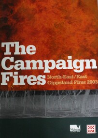
Book - The Campaign Fires - North-East/East Gippsland Fires 2003, Lyndel Hunter
... and forests, including 60 per cent of the Alpine National Park and 81... and forests, including 60 per cent of the Alpine National Park and 81 ...A description of efforts to fight the bushfires in Gippsland in 2003, including maps and illustrations. This volume was published as a tribute to the work of staff and volunteers who put themselves at risk to protect local communities. It shows the impact on those communities in Victoria and the support they gave to those involved in fighting largest bushfires in Victoria for 60 years. The Alpine bushfires started on 8th January 2003, a day of Total Fire Ban. Lightning ignited 87 fires in the North-East and East Gippsland regions. Eight of these fires were unable to be contained; they joined together to form the largest fire in Victoria since the Black Friday fires in 1939. The majority of the area burnt in Victoria was public land, 1.19 million hectares of parks and forests, including 60 per cent of the Alpine National Park and 81 per cent of the Mt Buffalo National Park. Firefighting efforts were made difficult in hard-to-access, remote forest terrain. Approximately 90,000 hectares of private land was burnt.This book is significant because it documents the 2003 Victorian Bushfires and serves as a tribute to the CFA staff and volunteers who fought them.This publication of 119 pages features text, colour images, maps and detailed information related to the 2003 bushfires in Victoria.At bottom of front cover:- CFA Victoria Logo Victorian Government Logovictorian fires 2003, cfa (vic)