Showing 861 items
matching national parks
-
 Merri-bek City Council
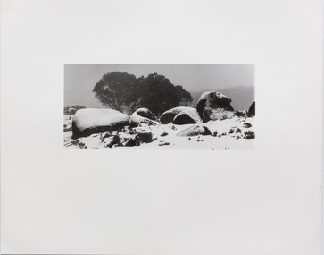
Hand printed vintage black and white silver print, Stephen Wickham, Untitled 9, c. 1980
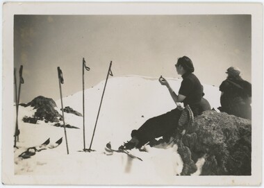
... in Victoria’s Mount Buffalo National Park, the Mount Buffalo series... in Victoria’s Mount Buffalo National Park, the Mount Buffalo series ...Stephen Wickham is an Australian photographer and painter who has been actively exhibiting his works since the 1980s. A long standing preoccupation with Mt Buffalo since the 1980's has seen the artist produce a number of photographic suites and exhibitions that have been likened to German Romantic iconography and associated heavily with the European migrant experience (Robert Nelson, The Age 16 June 2001). Born to Viennese parents, hiking in the mountains for Wickham represents a traditional European family pastime. This series of work is comprised of expeditionary photographs taken between 1980 and 1985. Charles Green describes Wickham's landscape photographs as sublime, transcendental, spiritual and symbolic (Art in Australia Spring 1988). Set in Victoria’s Mount Buffalo National Park, the Mount Buffalo series captures the mountain plateau during winter. Rather than focusing on a lush green landscape, Wickham presents the viewer with close-ups of the snow-covered flaura and fauna of the alpine region.Donated through the Australian Government's Cultural Gifts Program by Miriam Kenter in memory of Master George Willibrord Kenter -
 Merri-bek City Council
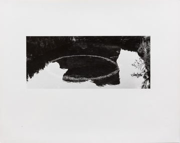
Hand printed vintage black and white silver print, Stephen Wickham, Untitled 10, c. 1980
... in Victoria’s Mount Buffalo National Park, the Mount Buffalo series... in Victoria’s Mount Buffalo National Park, the Mount Buffalo series ...Stephen Wickham is an Australian photographer and painter who has been actively exhibiting his works since the 1980s. A long standing preoccupation with Mt Buffalo since the 1980's has seen the artist produce a number of photographic suites and exhibitions that have been likened to German Romantic iconography and associated heavily with the European migrant experience (Robert Nelson, The Age 16 June 2001). Born to Viennese parents, hiking in the mountains for Wickham represents a traditional European family pastime. This series of work is comprised of expeditionary photographs taken between 1980 and 1985. Charles Green describes Wickham's landscape photographs as sublime, transcendental, spiritual and symbolic (Art in Australia Spring 1988). Set in Victoria’s Mount Buffalo National Park, the Mount Buffalo series captures the mountain plateau during winter. Rather than focusing on a lush green landscape, Wickham presents the viewer with close-ups of the snow-covered flaura and fauna of the alpine region.Donated through the Australian Government's Cultural Gifts Program by Miriam Kenter in memory of Master George Willibrord Kenter -
 Eltham District Historical Society Inc
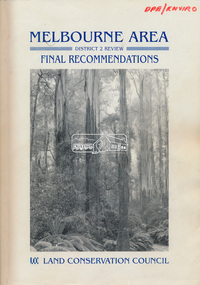
Book, Land Conservation Council, Melbourne Area, District 2 Review: Final Recommendations, 1994
... for the Yarra Ranges National Park were based around the closed... for the Yarra Ranges National Park were based around the closed ...Notices showing the boundary of the area of the review and advising that an investigation was to be carried out were published in the Victoria Government Gazette and in local and other Victorian newspapers in May 1987. A descriptive resources report was published in August 1991. Council received 1,425 submissions and letters following publication of the descriptive report. The Council considered these submissions and published proposed recommendations in April 1993. A further 1,993 submissions were received in response to the proposed recommendations. The Council published its final recommendations in July 1994. A change to legislation in 1989 enabled the LCC to make recommendations for public land within a ‘town’, though cities and rural cities remained excluded from the definition of public land. Timber resources and water quality and yield from timbered catchment areas remained significant issues in Melbourne’s catchments. Recommendations for the Yarra Ranges National Park were based around the closed Melbourne water catchments and adjoining state forest. A recommended Phillip Island State Park based around the penguin reserve was ultimately implemented as the Phillip Island Nature Park.Shire of Nillumbik DPE/Enviro -
 National Wool Museum
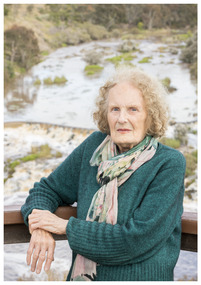
Photograph - Portrait of Joan Lindros, Nicole Marie, 2021
... the Otways campaign that resulted in the Great Otway National Park... the Otways campaign that resulted in the Great Otway National Park ...Thousands of volunteers work tirelessly to conserve and protect the environment of Geelong and the Bellarine. Their work often goes unnoticed. In 'The Work of Nature' the National Wool Museum and the Environment Department at the City of Greater Geelong worked with photographer Nicole Marie to showcase the significant contribution of environment volunteers in our region. Each of the eight people showcased in these portraits were nominated by their peers and members of the community for their significant contribution to conserving and protecting the environment. Joan Lindros - Geelong Environment Council Joan Lindros has been a mentor to community environmentalists across the Geelong region and beyond for many years. In 1972 she was a foundation member of the Geelong Environment Council. She was also instrumental in the Save the Otways campaign that resulted in the Great Otway National Park. Joan is an inspirational leader, tenacious advocate and a gentle person. In 2001 she was inducted into the Victorian Honour Role of Women. She continues to be involved in the Friends of Buckley Falls who have been working and advocating for the protection and restoration of the Barwon and Moorabool River Reserves for nearly forty years. Photo at Buckley Falls lookout by Nicole Marie.Image showing an environmental portrait of a woman leaning against wooden railing with trees, a river and a waterfall in the background.environment, conservation, portraits, geelong, nature, exhibition, work of nature, geelong nature forum, volunteers, buckley falls -
 Orbost & District Historical Society
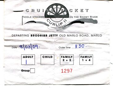
ticket, 8.03.2009
... of vast National Parks, the people of the region needed to create... of vast National Parks, the people of the region needed to create ...This is a ticket for one adult to cruise on the P.S.Curlip 11 which operated from the Brodribb Jetty in Marlo.from 2007 - 2015. "Paddle Steamer Curlip, a 62 feet long, traditional, plank on frame carved timber vessel, that was built by the people of East Gippsland at Orbost, in far Eastern Victoria. The undertaking to design and build this vessel, as a community project commenced in 2002. The community, based around Orbost was largely dependant on the Timber industry in the surrounding Victorian High Country. With the closure of Alpine logging and the creation of vast National Parks, the people of the region needed to create a major undertaking to bond the community and engender… a sense of belonging, this was critical for many of the men, who were dispossessed with the loss of their historical timber and forestry industry." (Information from website: https://www.curlip.com.au/) The Paddle Steamer Curlip 11 is a reproduction of the historic Curlip a small paddle steamer built by Samuel Richardson and his sons at his Tabbara sawmill near Orbost. It helped open up the region in the 1880’s before road or rail, serviced East Gippsland. Much work is being done to restore the Curlip 11 so that it can begin again as a tourist cruise boat.The P.S.Curlip 11 is Victoria's only Paddle Steamer. It was a community project involving many Orbost peolpe.A rectangular, white paper ticket with black print. In red is No. 1297 and the date and cruise time are hand-written in blue pen. ttached to the back of the ticket is a printed receipt.paddle-steamer-curlip 11 tourism-orbost -
 Wooragee Landcare Group
Photograph, 28th April 2004
... Mount Pilot Chiltern National Park... to find out if quolls still lived in Mount Pilot-Chiltern National... Andrew Murray Mount Pilot Chiltern National Park foxes endangered ...This photograph was taken at Wooragee Hall on the 28th of April, 2004, during an general information event titled "Questions About Quolls." The event was hosted by Andy Murray, then president of the South East Forests Spot-Tailed Quoll Working Group. Information provided included quoll characteristics, habitats, and how to find them. This event was partially prompted by a desire to find out if quolls still lived in Mount Pilot-Chiltern National Park, as there had been no confirmed sightings since the 2003 bushfires. Andy Murray helped lead the efforts to find them. Currently, landcare group efforts have found evidence of a small but present spot-tailed quoll population in the park. Reasons for the decrease in population include fox populations in the area and destruction of habitat. The man pictured in the photograph is Owen Gemmill(?) The spotted-tailed quoll, also called the Tiger Quoll, is an endangered Australian animal. It is the largest carnivorous mammal in Australia, and is native to Victoria, New South Wales, Queensland, and Tasmania. Slightly larger than a cat, the animals fur is normally brown, with black marking and white spots. Currently, there are approximately 14,000 spotted-tailed quolls in the wild. This photograph is significant as an example of events used by the Wooragee Landcare Group to inform the public on local environmental issues, and for its link to the hunt for the spotted-tailed quoll. Portrait colour photograph printed on gloss paper. Reverse: WAN NA 0ANA0N0 NN2+ 1 1636 quoll, south east forest spotted-tailed quoll working group, spotted-tailed quoll, tiger, mt pilot, andrew murray quolls, andy murray quolls, andrew murray, mount pilot chiltern national park, foxes, endangered quoll, queries about quolls, quoll species, wooragee, wooragee hall, wooragee landcare, wooragee landcare group, owen gemmill -
 Clunes Museum
Book, VICTORIAN MINISTRY FOR THE ARTS, THE OFFICIAL MUSEUMS DIRECTORY FOR VICTORIA
... PARKS, NATIONAL TRUST PROPERTIES, SCIENTIFIC COLLECTIONS..., HISTORIC HOUSES, HERITAGE PARKS, NATIONAL TRUST PROPERTIES ...THE MUSEUM'S ADVISORY BOARD OPERATES UNDER THEMUSUEMS ACT 1983 TO PROVIDE THE MINISTER WITH ADVICE ON THE DEELOPMENT OFMUSEUMS AND MSEUM SERVICES IN VICTORIA.1 PAPERBACK BOOK, GREEN COVER, PICTURE OF SPORT & OLYMPIC MUSEUM ON FRONT. PAGES, ROUND STICKER ON TOP RIGHT HAND CORNER -CM20. INCLUDED ARE: PUBLIC GALLERIES, HISTORIC HOUSES, HERITAGE PARKS, NATIONAL TRUST PROPERTIES, SCIENTIFIC COLLECTIONS AND HISTORICAL SOCIETY DISPLAYS, 217 PAGES .2 ADDENDUM AT 18/05/1990 ON OFF-WHITE PAPER (TRIFOLD)non-fictionTHE MUSEUM'S ADVISORY BOARD OPERATES UNDER THEMUSUEMS ACT 1983 TO PROVIDE THE MINISTER WITH ADVICE ON THE DEELOPMENT OFMUSEUMS AND MSEUM SERVICES IN VICTORIAmuseums directory, the official museums directory for victoria -
 Kiewa Valley Historical Society
Photograph - Mt Bogong - Tawonga, 06/05/1937
... Mount Bogong located in the Alpine National Park and part... Bogong located in the Alpine National Park and part ...Mount Bogong located in the Alpine National Park and part of the Victorian Alps of the Great Dividing Range, is the highest mountain in Victoria, Australia, at 1,986 metres (6,516 ft) above sea level. The Big River separates the massif of the mountain from the Bogong High Plains to the south. From the nearby town of Mount Beauty to its summit, Mount Bogong rises more than 1,600 metres (5,200 ft), thus making it one of the highest peaks in Australia not only in terms of its elevation above sea level, but also in terms of actual base-to-summit prominence. Mount Bogong is a popular backcountry skiing mountain through winter but only has snow for the mid winter-spring months. It is around 30 kilometres (19 mi) by road and walking track or 12 kilometres (7.5 mi) direct to Mount Beauty. Falls Creek and Mount Hotham ski resorts are also nearby. Camping is relatively safe below the tree line but the summit ridgeline is very exposed. Emergency shelter is also available at Bivouac Hut on the Staircase Spur, and at Cleve Cole, above Camp Creek on the broad ridge to the south of the summit, and Michells Hut on the Eskdale Spur. Mt Bogong is a popular recreational venue in the Kiewa Valley for back country skiing and bush walking and is a favourite with sightseers and popular subject for photographersBlack and white photograph of Mt bogong taken from Tawonga - Thursday May 6th, 1937Handwritten on back of photograph. Thursday May 6th, 1937. Mt Bogong Tawongamt bogong, tawonga, kiewa valley -
 Falls Creek Historical Society
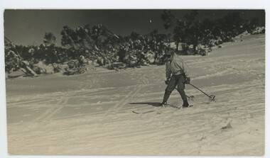
Photograph - John Meyer near Wilkie and Basalt Hill
... . In 1983, the National Parks Service described the building... to the Melbourne Bushwalkers club. In 1983, the National Parks Service ...MEYER COLLECTION - FALLS CREEK PHOTOS In 1947 a determined group of like-minded State Electricity Commission (SEC) staff including Ray Meyer, the chief surveyor of the Kiewa Hydro-Electric Scheme, had a common interest that revolved around the skiing potential of the snow-covered high plains which included what is now the resort of Falls Creek. The six SEC employees, Toni St Elmo, Ray Meyer, Jack Minogue, Lloyd Dunn, Adrian Ruffenacht and Dave Gibson (together with their families) banded together to secretly build a 'hut' that was the first ski lodge at Falls Creek. Using a road built in 1930s to gain access to Falls Creek, their hut project was carried out in secret as efforts by other skiers were blocked by H.H.C. Williams – the engineer in charge of the Hydro Scheme. In 1946 Ray Meyer made a trip to the Lands Office in Melbourne. He came away with a 99-year lease on three acres that was ideally suited for a hut designed by Lloyd Dunn. Adrian Ruffenacht (Design Engineer for the KHS) had suggested where the group should build because of easy access to a spring for water. Much of the building material required was scavenged from derelict huts on the high plains. Due to the need for secrecy, the determined group worked on the hut in the evenings and weekends to avoid detection. During the building period the group had met at Echidna Rock (now known as Eagle Rock) where Skippy St Elmo announced, "This is my favourite ‘Skyline’.” And so the first lodge in the area at Falls Creek Ski Resort came into existence. With the development of the International Poma in the 1970s, the Skyline Lodge, which was sited between the ski-lift’s pole one and pole two, was demolished. However, the legacy of Ray Meyer, Toni St Elmo, Jack Minogue, Lloyd Dunn, Adrian Ruffenacht and Dave Gibson and Skyline lives on in the vibrant atmosphere of Falls Creek Resort. The MEYER COLLECTION documents developments on the Kiewa Hydro Scheme and their life at Falls Creek from the mid 1930s to 1960s.These images are significant because they depict aspects of the life of a pioneering family of Falls Creek and the founders of "Skyline", the first lodge at Falls Creek.Two black and white images of John Meyer skiing near Wilkie and Basalt Hill, Bogong High Plains. Wilkinson’s Hut (Wilkie) was built for the SEC in the summer of 1932-3 to accommodate the snow research program manager. The cottage was sited next to a hydro-meteorological station, set on stilts above the snow. It was not a refuge hut but a permanent residence for all of the year. The work carried out there included operation of a meteorological station at the cottage, measuring the snow depth and density along two pole lines, and operating stream gauging stations in the area. The engineers stationed there included Adrian Rufenacht (1934-6), and Norwegian Martin Romuld (1936-42) Romuld was a champion skier, constructing a ski-jump and a grass tennis court near the hut during his residency. Adrian was one of the founders of 'Skyline". The hut was sold in 1948 to the Victorian Ski Club and renamed Wilkinson Lodge. Robert Wood Wilkinson, best known as 'Wilkie, was the 'Father figure' of Victorian skiing. Robert Wood Wilkinson died on May 22, 1939. The hut was resold some 12 years later to the Melbourne Bushwalkers club. In 1983, the National Parks Service described the building as an old SEC hut which had been purchased and, afterwards, maintained and occupied solely by the Melbourne Bushwalking Club. Wilkie Hut survived the 2003 bushfires but burnt down one year later (January 2004) in a cooking accident.falls creek, ray meyer, skyline -
 Falls Creek Historical Society
Photograph - Joan Meyer at Bogong High Plains
... . In 1983, the National Parks Service described the building.... In 1983, the National Parks Service described the building ...MEYER COLLECTION - FALLS CREEK PHOTOS In 1947 a determined group of like-minded State Electricity Commission (SEC) staff including Ray Meyer, the chief surveyor of the Kiewa Hydro-Electric Scheme, had a common interest that revolved around the skiing potential of the snow-covered high plains which included what is now the resort of Falls Creek. The six SEC employees, Toni St Elmo, Ray Meyer, Jack Minogue, Lloyd Dunn, Adrian Ruffenacht and Dave Gibson (together with their families) banded together to secretly build a 'hut' that was the first ski lodge at Falls Creek. Using a road built in 1930s to gain access to Falls Creek, their hut project was carried out in secret as efforts by other skiers were blocked by H.H.C. Williams – the engineer in charge of the Hydro Scheme. In 1946 Ray Meyer made a trip to the Lands Office in Melbourne. He came away with a 99-year lease on three acres that was ideally suited for a hut designed by Lloyd Dunn. Adrian Ruffenacht (Design Engineer for the KHS) had suggested where the group should build because of easy access to a spring for water. Much of the building material required was scavenged from derelict huts on the high plains. Due to the need for secrecy, the determined group worked on the hut in the evenings and weekends to avoid detection. During the building period the group had met at Echidna Rock (now known as Eagle Rock) where Skippy St Elmo announced, "This is my favourite ‘Skyline’.” And so the first lodge in the area at Falls Creek Ski Resort came into existence. With the development of the International Poma in the 1970s, the Skyline Lodge, which was sited between the ski-lift’s pole one and pole two, was demolished. However, the legacy of Ray Meyer, Toni St Elmo, Jack Minogue, Lloyd Dunn, Adrian Ruffenacht and Dave Gibson and Skyline lives on in the vibrant atmosphere of Falls Creek Resort. The MEYER COLLECTION documents developments on the Kiewa Hydro Scheme and their life at Falls Creek from the mid 1930s to 1960s.These images are significant because they depict aspects of the life of a pioneering family of Falls Creek and the founders of "Skyline", the first lodge at Falls Creek.Two black and white images of John Meyer skiing near Wilkie and Basalt Hill, Bogong High Plains. Wilkinson’s Hut (Wilkie) was built for the SEC in the summer of 1932-3 to accommodate the snow research program manager. The cottage was sited next to a hydro-meteorological station, set on stilts above the snow. It was not a refuge hut but a permanent residence for all of the year. The work carried out there included operation of a meteorological station at the cottage, measuring the snow depth and density along two pole lines, and operating stream gauging stations in the area. The engineers stationed there included Adrian Rufenacht (1934-6), and Norwegian Martin Romuld (1936-42) Romuld was a champion skier, constructing a ski-jump and a grass tennis court near the hut during his residency. Adrian was one of the founders of 'Skyline". The hut was sold in 1948 to the Victorian Ski Club and renamed Wilkinson Lodge. Robert Wood Wilkinson, best known as 'Wilkie, was the 'Father figure' of Victorian skiing. Robert Wood Wilkinson died on May 22, 1939. The hut was resold some 12 years later to the Melbourne Bushwalkers club. In 1983, the National Parks Service described the building as an old SEC hut which had been purchased and, afterwards, maintained and occupied solely by the Melbourne Bushwalking Club. Wilkie Hut survived the 2003 bushfires but burnt down one year later (January 2004) in a cooking accident.falls creek, joan meyer, bogong high plains -
 Parks Victoria - Mount Buffalo Chalet
Photograph, " DR J.F.WILKINSON"
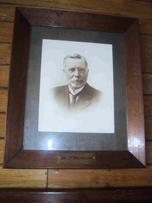
... of the first National Parks in Victoria, 1898. ... Mount Buffalo National Park Mt Buffalo high-country ...'There are also a number of framed portraits, including those of...Dr. John Wilkinson, a doctor who started a practise in Bright in the late 1880's and helped develop the tourist potential of the Mount Buffalo Plateau. " (Pg 84, Historica, 2011) Dr John .F. Wilkinson was a significant figure in the pioneering of tourism at Mt Buffalo. A Doctor and resident of Bright, he and W.A. Staker were the founder members of the Bright Alpine Club formed in 1887 to promote the natural attractions of the Buffalo plateau. " They form the Alpine Club and charge a membership fee for guiding people up the mountain (led by official guides Bill Weston and Edward Carlisle). this is matched by a grant from the local shire council.... They advertise in the Argus and promote the Australian Alps, Bright district as "The Switzerland of Victoria'. Mt Buffalo, with the railways nearby, is the most accessible snowfield and becomes 'the cradle of skiing in Victoria'." (Pg 179 Historica . 2011) The initial funds raised by the Alpine club funded the Staker's walking track, the first easily accessible route up the mountain. . They engaged the services of early Victorian photographer Nicholas Caire, whose scenic photographs helped to promote the beauty of the mountain. The efforts of these gentlemen culminated in securing 2.800 acres for the one of the first National Parks in Victoria, 1898. Listed in Draft Inventory of significant Items. Framed sepia photograph. Grey mount in wooden frame. Portrait of Dr.J.F Wilkinson. Brass name plaque at base of frame. Hand finished / highlighted in places." DR J.F.WILKINSON" -
 Melbourne Tram Museum
Album - A collection of, John Fitzsimons, "Tickets"
... and a Police ticket. 2 pages of unidentified tickets SPER National Park... and a Police ticket. 2 pages of unidentified tickets SPER National Park ...Contains the following tickets showing the style of tickets issued by various public transport operators. 3 pages of MMTB Imperial currency tickets 1 page of Pensioner concessions 3 pages of decimal currency tickets including dual currency type 1 page of Ultimate tickets - type sold at safety zones by Zone sellers 1 page of PMG prepaid tickets, special supplementary journal, machine bus ticket 1 page of PMG prepaid Section tickets, 1 page of incapacitated section tickets 2 pages of Hospital tickets Scholar's Concession ticket issued to the donor, Swimming class tickets and a Police ticket. 2 pages of unidentified tickets SPER National Park line 1 page of Adelaide tickets 4 pages of Provincial tramway tickets, dual currency including a Bendigo battery tram ticket. 3 pages of Brisbane tram and bus tickets 2 pages of Launceston bus tickets - 1968 1 page of Hobart tickets VR motor coach (bus) ticket 1 page of Perth tram tickets A TAA ground transport ticket San Francisco ticket, Hong Kong tickets, 2 pages of recovered MMTB tickets from behind tramcar seats - imperial currency and one MMTB Supplementary Running Journal.Yields information about the style of tickets issued by Australian Public Transport systems.Album - heavy black/green card covers containing 35 ruled quarto sheets secured with an Arnos metal binder with the title "Tickets" taped to the front of the object.tramways, melbourne, tickets, ballarat, bendigo, adelaide, launceston, hobart, brisbane, hong kong, taa airlines, perth, san francsico, sper, pmg -
 National Wool Museum
Artwork, other - Paper Taxidermy, Mary-Jane Walker, Plains Wanderer, 2020
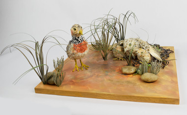
... Terrick Terrick National Park... increasing in Terrick Terrick National Park in north west Victoria... increasing in Terrick Terrick National Park in north west Victoria ...The world’s most ecologically distinct bird lives in the native grasslands of Victoria - but only just. The plains-wanderer is a small bird that was once widespread across the grasslands of south-eastern Australia. Today there are fewer than 1000 mature birds in the wild. The plains-wanderer is under threat due to habitat loss caused by overgrazing, cropping and suburban sprawl. Unlike most other birds, female wanderers are larger and more colourful and the males take care of the chicks. They are only about 15cm tall and weigh between 40-80g for the male and 55-90g for the female. Their intricate plumage mirrors the colours of their grassland home so they blend in perfectly with their surroundings. The plains-wanderer’s origins date back to when Australia was part of the Gondwana supercontinent over 60 million years ago. They are so biologically distinct that their extinction would result in the loss of a branch of the tree of life. A fussy grass dweller, they like neither too much nor too little grass. That is where sheep grazing can help. After years of low numbers in Victoria, plains-wanderer populations have been increasing in Terrick Terrick National Park in north west Victoria, as sheep grazing maintains the grass in the park at a suitable level. With the right management, this ecologically important bird species is continuing to survive in the native grasslands of Victoria. Managing these habitats for the plains-wanderer can also support the conservation of many other threatened plant and animal species. Object: Nest of plains-wanderers by Mary-Jane Walker, 2020. Outer made from upcycled paper, internal structure steel. Nest of plains-wanderers by Mary-Jane Walker, 2020. Outer made from up cycled paper, internal structure steel. native grasslands, plains-wanderer, terrick terrick national park -
 Forests Commission Retired Personnel Association (FCRPA)
Beechworth FCV District office sign
... , National Park Service, Soil Conservation Authority and Fisheries..., National Park Service, Soil Conservation Authority and Fisheries ...This sign proudly hung outside the Forests Commission Victoria (FCV) Beechworth office which is now site of the Forestry Heritage Museum. The granite building in the Beechworth's historic precinct was once the Gold Warden's Office and is one of the town's original buildings. The FCV was the main government authority responsible for management and protection of State forests in Victoria between 1918 and 1983. The Commission was responsible for ″forest policy, prevention and suppression of bushfires, issuing leases and licences, planting and thinning of forests, the development of plantations, reforestation, nurseries, forestry education, the development of commercial timber harvesting and marketing of produce, building and maintaining forest roads, provision of recreation facilities, protection of water, soils and wildlife, forest research and making recommendations on the acquisition or alienation of land for forest purposes″. The Forests Commission had a long and proud history of innovation and of managing Victoria's State forests but in September 1983 lost its discrete identity when it was merged into the newly formed Victorian Department of Conservation, Forests and Lands (CFL) along with the Crown Lands and Survey Department, National Park Service, Soil Conservation Authority and Fisheries and Wildlife Service. After the amalgamation the management of State forests and the forestry profession continued but the tempo of change accelerated, with many more departmental restructures occurring over the subsequent four decades. Responsibilities are currently split between the Department of Energy, Environment and Climate Action (DEECA), Forests Fire Management Victoria (FFMV), Parks Victoria, Melbourne Water, Alpine Resorts Commission, the State Government-owned commercial entity VicForests and the privately owned Hancock Victorian Plantations (HVP).Large office sign. Hand painted in traditional FCV mission brown and gold colour scheme.forests commission victoria (fcv), forest signs -
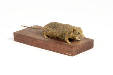 The Beechworth Burke Museum
Animal specimen - Dusky Antechinus, Trustees of the Australian Museum, 1860-1880
... areas, including Kosciuszko National Park and the Brindabella... areas, including Kosciuszko National Park and the Brindabella ...The dusky antechinus was first described in 1840 by English naturalist George Robert Waterhouse, making it the second species of antechinus to be formally recorded. It was named in honor of zoologist and artist William Swainson, with the holotype likely originating from the Tasman Peninsula in Tasmania, collected by Swainson’s associate, Thomas Lempriere. The dusky antechinus is distributed across southeastern Queensland to southwestern Victoria, as well as in Tasmania. It is most frequently found in mountainous areas, including Kosciuszko National Park and the Brindabella Ranges, where it inhabits alpine heath and tall open forests with dense understorey vegetation. While the species is not considered threatened, some local populations have declined due to habitat loss caused by controlled burning and the replacement of native forests with pine plantations. Additionally, predation by cats and red foxes is believed to negatively impact its numbers. This specimen was originally identified as a bandicoot and is part of a collection of almost 200 animal specimens that were originally acquired as skins from various institutions across Australia, including the Australian Museum and the National Museum of Victoria, as well as individuals such amateur anthropologist Reynell Eveleigh Johns between 1860-1880. These skins were then mounted by members of the Burke Museum Committee and put-on display in the formal space of the Museum’s original exhibition hall where they continue to be on display. This display of taxidermy mounts initially served to instruct visitors to the Burke Museum of the natural world around them, today it serves as an insight into the collecting habits of the 19th century. This specimen is part of a significant and rare taxidermy mount collection in the Burke Museum. This collection is scientifically and culturally important for reminding us of how science continues to shape our understanding of the modern world. They demonstrate a capacity to hold evidence of how Australia’s fauna history existed in the past and are potentially important for future environmental research. This collection continues to be on display in the Museum and has become a key part to interpreting the collecting habits of the 19th century.Small sized dusky antechinus with a pointy snout, small rounded eyes made of glass, a thin tail, small rounded ears, and sharp clawed legs. The fur in colouring is golden brown with streaks of dark brown, and is of medium length and fine.On wooden mount: BMM5896/ On Catalogue Tag (attached to left foreleg): Bandicoot Mou(...)/ Catalogue, Page. 45/ burke museum, taxidermy, taxidermy mount, fauna, animal, animalia, reynell eveleigh johns, bandicoot, marsupial, peramelemorphia, dusky antechinus, antechinus swainsonii, swainson's antechinus, dusky marsupial mouse -
 Kiewa Valley Historical Society
Maps - Bogong x2, Tawonga, Omeo, Dargo, Victoria and others, 1. Bogong Alpine Area; 2. Bogong 8324; 3. Tawonga Topographical; 4. Omeo 8433; 5. Dargo 8323; 6. Victoria State
... . Information for tourist in the Alpine National Park: Bogong Area... in the Alpine National Park: Bogong Area. Including: recreational ...1. Bogong Alpine Area (outdoor Leisure Map. survey & Mapping Victoria, Government of Victoria, Edition 2, reprinted 1991 with an image of Mt. Feathertop on the front. Information for tourist in the Alpine National Park: Bogong Area. Including: recreational activities, history, weather and vegetation and a list of walks together with locality maps and photographs. The front cover has an image of Mt Feathertop against a blue sky with yellow writing 'Bogong Alpine Area', there is a yellow triangular block on the right hand top corner with black writing 'Outdoor Leisure Map. On the bottom edge is a block of yellow with black writing 'Survey & Mapping Victoria' and a light green map of Victoria with 'VICMSP' printed in white. 2. 8324 Bogong Victoria, Edition 1, Commonwealth of Australia 1981. A topographical Map: 1:100,000 scale (1 cm to 1 KM). Map has a red cover with white writing together with a white block and black writing and a map insert. 3. Tawonga Topographical Map - Forests Commission Victoria, / revised 5/9/77, DEG No. 68-G/399. A Tawonga 803 folded map in a beige colour with the back blank. 4. Omeo 8433 Victoria, Edition 1, Department of Natural Resources. The map has a red and white cover with black writing and a simple map of Australia at the bottom. 5. 8323 Dargo, Edition 1, Commonwealth of Australia. A red and white cover with a map insert. 6. Victoria State Map, Hema Maps, 2002. Hema Maps, State Map, colourful cover with a map of Australia and four tourism photographs. Scale 1: 850,000 An inscription handwritten in blue pen "Trappers Gap to Mitta Mitta 1" to 1 mile". There are some pen markings and notations of tracks.maps, bogong, omeo, tawonga, dargo, victoria, bogong alpine area -
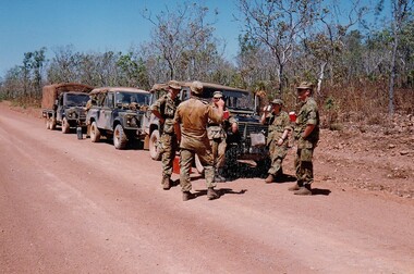 8th/13th Victorian Mounted Rifles Regimental Collection
Photograph
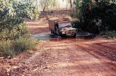
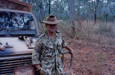
... National park across the East Alligator River to Oenpelli... National park across the East Alligator River to Oenpelli ...The Dibb Report into mainland defence of Australia,1986, among other things identified the requirement for protection of key assets in Northern Australia and the possibility of involving Army Reserve (Ares) units in this thus releasing regular forces for offensive operations. Dibb also pointed out that this defined role would result in a huge lift in Ares morale. In June 1988, the 3rd Division (3Div) conducted a Tactical Exercise without Troops (TEWT), Exercise ‘Distant Trumpet’ in the Katherine- Darwin area to study problems associated with defence against low level incursions against Tindal RAAF Base. Exercise ‘Northern Explorer’ followed in October of that year when units of the 3Div including A Squadron 8/13 Victorian Mounted Rifles sent patrol groups to get a first taste of environment and conditions. Post-Exercise reports had to include recommendations re: health, equipment and adaptation of Standing Operating Procedures (SOPs) in preparation for the new role deploying to Northern Australia. The first deployment by 8/13 Victorian Mounted Rifles was in 1988. Deployments continued in following years. In September 1993, 3 Troop (Wangaratta) VMR Squadron 4/19 PWLH commanded by Captain Kelvin Robertson deployed to NT. The training began with airfield defence at Tindal followed by a 1000km recon into Arnhem Land in four Landrovers. The troop reported on the conditions of the roads, airfields, bridges (mainly causeways) resources such as fuel supplies in the towns and infrastructure. Each troop taking different route. 3 Troop had the Northern route through Kakadu National park across the East Alligator River to Oenpelli then to Maningrida and Ramangining and south to the Central Arnhem Road and back to Tindal Air force Base. Colour photograph of five soldiers and three vehicles of VMR Squadron,4/19 Prince of Wales's Light Horse on roadside during annual exercise in Northern Territory 1994.military, vehicles, soldiers, northern territory, training, vmr -
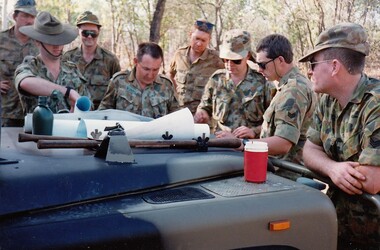 8th/13th Victorian Mounted Rifles Regimental Collection
Photograph
... National park across the East Alligator River to Oenpelli... National park across the East Alligator River to Oenpelli ...The Dibb Report into mainland defence of Australia,1986, among other things identified the requirement for protection of key assets in Northern Australia and the possibility of involving Army Reserve (Ares) units in this thus releasing regular forces for offensive operations. Dibb also pointed out that this defined role would result in a huge lift in Ares morale. In June 1988, the 3rd Division (3Div) conducted a Tactical Exercise without Troops (TEWT), Exercise ‘Distant Trumpet’ in the Katherine- Darwin area to study problems associated with defence against low level incursions against Tindal RAAF Base. Exercise ‘Northern Explorer’ followed in October of that year when units of the 3Div including A Squadron 8/13 Victorian Mounted Rifles sent patrol groups to get a first taste of environment and conditions. Post-Exercise reports had to include recommendations re: health, equipment and adaptation of Standing Operating Procedures (SOPs) in preparation for the new role deploying to Northern Australia. The first deployment by 8/13 Victorian Mounted Rifles was in 1988. Deployments continued in following years. In September 1993, 3 Troop (Wangaratta) VMR Squadron 4/19 PWLH commanded by Captain Kelvin Robertson deployed to NT. The training began with airfield defence at Tindal followed by a 1000km recon into Arnhem Land in four Landrovers. The troop reported on the conditions of the roads, airfields, bridges (mainly causeways) resources such as fuel supplies in the towns and infrastructure. Each troop taking different route. 3 Troop had the Northern route through Kakadu National park across the East Alligator River to Oenpelli then to Maningrida and Ramangining and south to the Central Arnhem Road and back to Tindal Air force Base. Colour photograph of group of soldiers of VMR Squadron 4/19Prince of Wales's Light Horse studying maps on bonnet of Land Rover during annual exercise in Northern Territory 1994.Major M. Annett wearing slouch hat, Sergeant Gary Wynn,without hat,,on his left. -
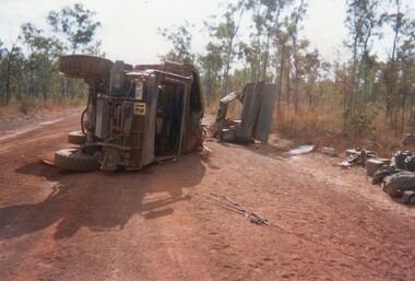 8th/13th Victorian Mounted Rifles Regimental Collection
Photograph
... National park across the East Alligator River to Oenpelli... National park across the East Alligator River to Oenpelli ...The Dibb Report into mainland defence of Australia,1986, among other things identified the requirement for protection of key assets in Northern Australia and the possibility of involving Army Reserve (Ares) units in this thus releasing regular forces for offensive operations. Dibb also pointed out that this defined role would result in a huge lift in Ares morale. In June 1988, the 3rd Division (3Div) conducted a Tactical Exercise without Troops (TEWT), Exercise ‘Distant Trumpet’ in the Katherine- Darwin area to study problems associated with defence against low level incursions against Tindal RAAF Base. Exercise ‘Northern Explorer’ followed in October of that year when units of the 3Div including A Squadron 8/13 Victorian Mounted Rifles sent patrol groups to get a first taste of environment and conditions. Post-Exercise reports had to include recommendations re: health, equipment and adaptation of Standing Operating Procedures (SOPs) in preparation for the new role deploying to Northern Australia. The first deployment by 8/13 Victorian Mounted Rifles was in 1988. Deployments continued in following years. In September 1993, 3 Troop (Wangaratta) VMR Squadron 4/19 PWLH commanded by Captain Kelvin Robertson deployed to NT. The training began with airfield defence at Tindal followed by a 1000km recon into Arnhem Land in four Landrovers. The troop reported on the conditions of the roads, airfields, bridges (mainly causeways) resources such as fuel supplies in the towns and infrastructure. Each troop taking different route. 3 Troop had the Northern route through Kakadu National park across the East Alligator River to Oenpelli then to Maningrida and Ramangining and south to the Central Arnhem Road and back to Tindal Air force Base. Two colour photographs of vehicle mishap during VMR Squadron 4/19Prince of Wales's Light Horse annual exercise in Northern Territory 1994.Second photo shows driver receiving medical attention. -
 8th/13th Victorian Mounted Rifles Regimental Collection
Photograph
... National park across the East Alligator River to Oenpelli... National park across the East Alligator River to Oenpelli ...The Dibb Report into mainland defence of Australia,1986, among other things identified the requirement for protection of key assets in Northern Australia and the possibility of involving Army Reserve (Ares) units in this thus releasing regular forces for offensive operations. Dibb also pointed out that this defined role would result in a huge lift in Ares morale. In June 1988, the 3rd Division (3Div) conducted a Tactical Exercise without Troops (TEWT), Exercise ‘Distant Trumpet’ in the Katherine- Darwin area to study problems associated with defence against low level incursions against Tindal RAAF Base. Exercise ‘Northern Explorer’ followed in October of that year when units of the 3Div including A Squadron 8/13 Victorian Mounted Rifles sent patrol groups to get a first taste of environment and conditions. Post-Exercise reports had to include recommendations re: health, equipment and adaptation of Standing Operating Procedures (SOPs) in preparation for the new role deploying to Northern Australia. The first deployment by 8/13 Victorian Mounted Rifles was in 1988. Deployments continued in following years. In September 1993, 3 Troop (Wangaratta) VMR Squadron 4/19 PWLH commanded by Captain Kelvin Robertson deployed to NT. The training began with airfield defence at Tindal followed by a 1000km recon into Arnhem Land in four Landrovers. The troop reported on the conditions of the roads, airfields, bridges (mainly causeways) resources such as fuel supplies in the towns and infrastructure. Each troop taking different route. 3 Troop had the Northern route through Kakadu National park across the East Alligator River to Oenpelli then to Maningrida and Ramangining and south to the Central Arnhem Road and back to Tindal Air force Base. Two colour photographs of creek crossings, one more challenging than the other,during the annual exercise in Northern Territory, conducted by VMR Squadron 4/19 Prince of Wales's Light horse, 1994. -
 8th/13th Victorian Mounted Rifles Regimental Collection
Photograph
... National park across the East Alligator River to Oenpelli... National park across the East Alligator River to Oenpelli ...The Dibb Report into mainland defence of Australia,1986, among other things identified the requirement for protection of key assets in Northern Australia and the possibility of involving Army Reserve (Ares) units in this thus releasing regular forces for offensive operations. Dibb also pointed out that this defined role would result in a huge lift in Ares morale. In June 1988, the 3rd Division (3Div) conducted a Tactical Exercise without Troops (TEWT), Exercise ‘Distant Trumpet’ in the Katherine- Darwin area to study problems associated with defence against low level incursions against Tindal RAAF Base. Exercise ‘Northern Explorer’ followed in October of that year when units of the 3Div including A Squadron 8/13 Victorian Mounted Rifles sent patrol groups to get a first taste of environment and conditions. Post-Exercise reports had to include recommendations re: health, equipment and adaptation of Standing Operating Procedures (SOPs) in preparation for the new role deploying to Northern Australia. The first deployment by 8/13 Victorian Mounted Rifles was in 1988. Deployments continued in following years. In September 1993, 3 Troop (Wangaratta) VMR Squadron 4/19 PWLH commanded by Captain Kelvin Robertson deployed to NT. The training began with airfield defence at Tindal followed by a 1000km recon into Arnhem Land in four Landrovers. The troop reported on the conditions of the roads, airfields, bridges (mainly causeways) resources such as fuel supplies in the towns and infrastructure. Each troop taking different route. 3 Troop had the Northern route through Kakadu National park across the East Alligator River to Oenpelli then to Maningrida and Ramangining and south to the Central Arnhem Road and back to Tindal Air force Base Major Annett later commanded 4/19 Prince of Wales's Light Horse, and later again 4th Brigade 2nd Division.. Colour photograph of Major M. Annett, Officer Commanding VMR Squadron 4/19Prince of Wales's Light Horse during annual exercise Northern Territory 1994. -
 Surrey Hills Historical Society Collection
Photograph, 'Glenisla', 18 Chestnut Street, Surrey Hills, c 1920, 1920
... National Park. This was established as a super-fine wool stud... and on the edge of the Grampians National Park. This was established ...Date is approximate. In 1920 this became the home of Mr and Mrs Robert Moore, whose daughter Mabel Annie married Norman Brodley Carter of Mont Albert. The house was named after 'Glenisla', a western District grazing property located between Hamilton and Horsham on the Henty Highway and on the edge of the Grampians National Park. This was established as a super-fine wool stud in 1860 and was passed down the family until it was sold in 1922. The family transferred from this property to Melbourne. Robert is listed as a grazier in the 1924 electoral roll at Chestnut Street. With him are Victor Cecil listed as a carpenter; Isabella, Mabel Annie and Edgar Gilbert listed as an orchardist. In 2003 the house was extant minus the verandas. This photo may have been taken from the rear of the property. Ref: History of original property - Age newspaper article: 'The Best - Glenisla: historic Grampians property', 7 January 1994. Moore family details: Robert Moore born 1857 on Isle of Man; died Surrey Hills 1940 Isabella Bateson born 1869; died Surrey Hills 1938 Married in 1894 in Miram, 10 km north-east of Kaniva in the northern Wimmera. All the children were born in Kaniva. Children: Lena Florence (1895-1980) Victor Cecil (1896-1984) - a builder Edgar Gilbert (1897-1976); died Surrey Hills; married Myrtle Emary, daughter of Henry John Emary of Surrey Hills Ernest Alan (1900-1900) Mabel Annie (1901-1957); died Surrey Hills married Norman Brodley Carter (1899-1984) Clarence Arthur (1904-2004). Norman Carter took many photos in the Surrey Hills and Mont Albert are from the 1920s; many is connection with Church of England events and activities. Robert and Isabella Moore are buried in Box Hill Cemetery. Black and white photo of a Victorian home with a veranda with a corrugated iron roof and lacework on 2 sides. It appears to have a later extension at the rear. It is surrounded by mature gardens with ornamental trees (cypresses) and an area with plants in rows, which may be a vegetable garden. There appears to be significant areas of open space around the house.glenisla, homes, victorian style, gardens, norman carter, robert moore, miss isabella bateson, mrs isabella moore, victor cecil moore, edgar gilbert moore, miss mabel annie moore, box hill cemetery -
 Bendigo Historical Society Inc.
Newspaper - PETER ELLIS COLLECTION: NEWSPAPER ARTICLE, 22nd May, 2015
... for the inclusion of One Tree Hill in the Greater Bendigo National Park... for the inclusion of One Tree Hill in the Greater Bendigo National Park ...Newspaper article from the Bendigo Advertiser stuck on A4 printer paper. Article is dated Friday, May 22, 2015. Article is accompanied by a picture of Peter Ellis and is captioned as such. Article is written by Jason Walls and is titled Loss for folk music history. Article reads: Celebrated Bendigo Music identity, historian and naturalist Peter Ellis OAM died suddenly this week after a brief illness. He was 69. Mr Ellis was highly regarded as a collector and preserver of traditional bush music, with his collection of dance related material the largest in the National Library Archives in Canberra. He was award an Order of Australia Medal in 2012 for services to the arts through the collection and preservation of Australian folk history and heritage. Mr Ellis was a founding member of the Emu Creek Bush Band and achieved two platinum and several gold records in his more than 30 years with the Wedderburn Old Timers Band. Fellow Emu Creek Bush Band member and close friend John Williams said Mr Ellis had made an invaluable contribution to the preservation of Australia's musical and dance heritage, travelling extensively across the country recording and notating folk music. 'In 500 year's time, as long as they can find the technology, people will be able to resurrect our bush dancing history,' he said. 'Probably his biggest legacy is the number of young people who have been made aware of bush music and are continuing to play it today and will play it in the future.' As a life member of the Bendigo Field Naturalists Mr Ellis was also involved in campaigns to establish the Whipstick and Kamarooka State Parks and the Saloman's Gully and Jackass Flat Flora Reserves, and lobbied for the inclusion of One Tree Hill in the Greater Bendigo National Park. A public funeral service will beheld at the Mulqueen Family Chapel on Bridge Street on Monday, May 25, at 11am, followed by a private cremation. An extensive obituary will be published in Saturday's Bendigo Advertiser.person, individual, peter ellis oam -
 Uniting Church Archives - Synod of Victoria
Photograph, St Philip's College Alice Springs - Principal Chris Tudor & Deputy Principal Chris Eldridge, 09/1986
... on to the Telegraph Station National Park - was secured and after six years... and Todd Rivers and backing on to the Telegraph Station National ...In 1945 the Reverend Harry Griffiths, who worked for the Methodist Inland Mission in Alice Springs, saw the need for a boarding facility for children of families living in remote areas in Central Australia who needed access to schools. He and his wife established Griffiths House, on a site in the town centre, and for many years it became home for students from all over the Outback, including many young Aboriginal people. In the late 1950's the Rev Fred McKay, successor to the Rev John Flynn as Superintendent of the Australian Inland Mission, lobbied the United Church in the Northern Territory to build and expand on this important start. Together the Presbyterian, Methodist and Congregational churches embarked on a missionary venture to develop St Philip's College - a new, larger residential hostel which would one day become a full boarding school. An ideal site - 22 acres of bush at the junction of the Charles and Todd Rivers and backing on to the Telegraph Station National Park - was secured and after six years of planning, construction began in 1964. Fred McKay led the legendary work parties comprised of volunteers from all over Australia who travelled to Alice Springs, paying their own way and volunteering their expertise, time and labour, to turn a dream into a reality. This fantastic tradition continues today, with work parties arriving each mid-year holiday. On 13 February 1965 the first boarders moved in to St Philip's College. For the first 24 years, therefore, St Philip's College operated as a residential hostel only. The College’s ninth Headmaster, Mr Christopher Tudor, arrived in 1986. He and the Council Chairman, Mrs Jan Heaslip, judged that the time was right to complete the original plan to turn St Philip’s College into a fully fledged independent boarding/day school, serving not only “bush” families, but also the growing population of Alice Springs. The then College Council embraced the idea and three years of frantic, determined preparation and planning commenced, culminating in an extensive $2 million building program in 1988. To this day there continues to be further development with the new landscaping underway near The Minnamurra Hall, Reception and Rivergum Cafe, plus the recent completion of the Science & Food Technology building and the new Rivergum Cafe.Head & Shoulders of Chris Eldridgest. philip's college, tudor, chris, eldridge, chris -
 Uniting Church Archives - Synod of Victoria
Photograph, St Philip's College Alice Springs - Principal Chris Tudor & Deputy Principal Chris Eldridge, 09/1986
... on to the Telegraph Station National Park - was secured and after six years... and Todd Rivers and backing on to the Telegraph Station National ...In 1945 the Reverend Harry Griffiths, who worked for the Methodist Inland Mission in Alice Springs, saw the need for a boarding facility for children of families living in remote areas in Central Australia who needed access to schools. He and his wife established Griffiths House, on a site in the town centre, and for many years it became home for students from all over the Outback, including many young Aboriginal people. In the late 1950's the Rev Fred McKay, successor to the Rev John Flynn as Superintendent of the Australian Inland Mission, lobbied the United Church in the Northern Territory to build and expand on this important start. Together the Presbyterian, Methodist and Congregational churches embarked on a missionary venture to develop St Philip's College - a new, larger residential hostel which would one day become a full boarding school. An ideal site - 22 acres of bush at the junction of the Charles and Todd Rivers and backing on to the Telegraph Station National Park - was secured and after six years of planning, construction began in 1964. Fred McKay led the legendary work parties comprised of volunteers from all over Australia who travelled to Alice Springs, paying their own way and volunteering their expertise, time and labour, to turn a dream into a reality. This fantastic tradition continues today, with work parties arriving each mid-year holiday. On 13 February 1965 the first boarders moved in to St Philip's College. For the first 24 years, therefore, St Philip's College operated as a residential hostel only. The College’s ninth Headmaster, Mr Christopher Tudor, arrived in 1986. He and the Council Chairman, Mrs Jan Heaslip, judged that the time was right to complete the original plan to turn St Philip’s College into a fully fledged independent boarding/day school, serving not only “bush” families, but also the growing population of Alice Springs. The then College Council embraced the idea and three years of frantic, determined preparation and planning commenced, culminating in an extensive $2 million building program in 1988. To this day there continues to be further development with the new landscaping underway near The Minnamurra Hall, Reception and Rivergum Cafe, plus the recent completion of the Science & Food Technology building and the new Rivergum Cafe.Head & Shoulders of Chris Tudor.st. philip's college, tudor, chris, eldridge, chris -
 Uniting Church Archives - Synod of Victoria
Photograph, St Philip's College Alice Springs - Principal Chris Tudor & Deputy Principal Chris Eldridge, 09/1986
... on to the Telegraph Station National Park - was secured and after six years... and Todd Rivers and backing on to the Telegraph Station National ...In 1945 the Reverend Harry Griffiths, who worked for the Methodist Inland Mission in Alice Springs, saw the need for a boarding facility for children of families living in remote areas in Central Australia who needed access to schools. He and his wife established Griffiths House, on a site in the town centre, and for many years it became home for students from all over the Outback, including many young Aboriginal people. In the late 1950's the Rev Fred McKay, successor to the Rev John Flynn as Superintendent of the Australian Inland Mission, lobbied the United Church in the Northern Territory to build and expand on this important start. Together the Presbyterian, Methodist and Congregational churches embarked on a missionary venture to develop St Philip's College - a new, larger residential hostel which would one day become a full boarding school. An ideal site - 22 acres of bush at the junction of the Charles and Todd Rivers and backing on to the Telegraph Station National Park - was secured and after six years of planning, construction began in 1964. Fred McKay led the legendary work parties comprised of volunteers from all over Australia who travelled to Alice Springs, paying their own way and volunteering their expertise, time and labour, to turn a dream into a reality. This fantastic tradition continues today, with work parties arriving each mid-year holiday. On 13 February 1965 the first boarders moved in to St Philip's College. For the first 24 years, therefore, St Philip's College operated as a residential hostel only. The College’s ninth Headmaster, Mr Christopher Tudor, arrived in 1986. He and the Council Chairman, Mrs Jan Heaslip, judged that the time was right to complete the original plan to turn St Philip’s College into a fully fledged independent boarding/day school, serving not only “bush” families, but also the growing population of Alice Springs. The then College Council embraced the idea and three years of frantic, determined preparation and planning commenced, culminating in an extensive $2 million building program in 1988. To this day there continues to be further development with the new landscaping underway near The Minnamurra Hall, Reception and Rivergum Cafe, plus the recent completion of the Science & Food Technology building and the new Rivergum Cafe.Tudor and Eldridge in conversation with the College in the background.st. philip's college, tudor, chris, eldridge, chris -
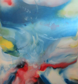 Federation University Art Collection
Painting, Norman Hofmaier, 'Promethius 1 from the Mallee Mysteries Series', by Norman Hofmaier
... of the flora and fauna of the Mallee. The Wyperfeld National Park, home... of the Mallee. The Wyperfeld National Park, home to the Big Desert ...Norman Keith HOFMAIER (12.08.1951- ) Born Beulah, Wimmera, Victoria Norman Hofmaier was a scion of a well-known family, he completed his secondary education at Hopetoun High School and Ballarat College. Later he studied Visual Art at University of Ballarat, including painting, design and sculpture. Hofmaier’s childhood in Beulah was spent on the family property running beside the Yarriambiack Creek. Both he and his father had an intimate knowledge of the flora and fauna of the Mallee. The Wyperfeld National Park, home to the Big Desert, was a favourite place for Norman’s uncle who planted acres of native trees at the family property. Dr Di Bresciani explains: “The colours and vastness of the Mallee are represented in many works which reflect, variously, the relentless quiet and swirling energies found in the ‘dust storm might’ of the Mallee area. Most works may be described as abstract, lyrical abstract or abstract expressionist." From the 1970s until the 1990s he began an outpouring of work, using oil-based paints overlaid manually on large, specially-prepared boards using brushes, cloths, sponges, sprays or rollers. Petrol solvents were used to soften, blur and enhance shapes and edges. His work reflected his exploration of his inner state, sometimes flowing and placid, sometimes tempestuous. After a brief sojourn into city-life Norman returned to working in the country, until finally submitting to mental illness and permanent care in the mid 1990s. Norman Hofmaier's works are represented in major collections including that of the well- known artist Mitch Pearson ( an important influence and lifelong friend). The work 'Pastel of a Nude' was shown in a widely distributed magazine and two works owned by Mark Shannon were planned to be published as record covers in 1993. He won an award during the bicentennial recognising his skill as a Wimmera artist. From the 1970s until the 1990s he began an outpouring of work, using oil-based paints overlaid manually on large, specially-prepared boards using brushes, cloths, sponges, sprays or rollers. Petrol solvents were used to soften, blur and enhance shapes and edges. This work was purchased from the exhibition 'Norman Hofmaier: Mallee Mysteries' at the Lost Ones Gallery in Camp Street, Ballarat. The exhibition explored the legacy of Hofmaier’s work as well as raising money for the Ballarat Art Foundation. The Hofmaier family donated 16 works of the artist to be sold to raise funds for the foundation, to support emerging artists.Original painting in square format, featuring abstract swirls of blue, white, red, yellow and green.On back of work: 1. pools of diluted oil paint covering approximately 8 cm from each edge, 2. in right hand corner in permanent marker "N Hofmaier" 3. middle right hand side, torn exhibition label, with the words, "Belauh", "Local Art", "Prome", "Local Art", "$350", "Collect A", "oin" 4. Bottom right corner, two exhibition labels on card. Cards read: The flowing of movement before any known bodies are formed. Matter and gases bubble forming kaleidoscopic colours and shapes. Promethius 1 Oil based pigment with petrol on prepared board 1320 x 1210 mm On front of work, bottom right hand corner, in white lettering, N Hofmaier. Bottom right hand olive green frame damaged on front of work.painter, mallee, beluah, norman hofmaier, wimmera, abstract, alumni -
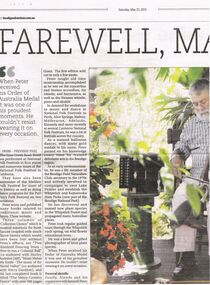 Bendigo Historical Society Inc.
Document - PETER ELLIS COLLECTION: NEWSPAPER ARTICLE, 23rd May, 2015
... National Park). He has discovered and named new plant species... National Park). He has discovered and named new plant species ...Colour photocopy of article from Bendigo Advertiser. Dated Saturday, May 23, 2015. FAREWELL, MA.. When Peter received his Order of Australia Medal it was one of his proudest moments. He couldn’t resist wearing it on every occasion. FROM - PREVIOUS PAGE The Emu Creek Bush Band has performed at National Folk Festivals in four states and numerous times at the National Folk Festival in Canberra. They have also been mainstays of the Maldon Folk Festival for most of its history as well as doing dance programs for the Port Fairy Folk Festival on two occasions. Peter wrote and published many books related to traditional music and dance. These include: Three volumes of 'Collector's Choice' which is musical notations for bush dances coupled with much dance history which would have been lost without Peter's efforts, are 'Two Hundred Dancing Years- How to run a Colonial Ball' (Co-authored with Shirley Andrews (AM), 'Music Makes Me Smile- The Music of the Nariel Valley' (Co-authored with Harry Gardner), and his last completed book is titled 'The Merry Country Dance' with over 300 pages.. .. .. Grant. The first edition sold out in only a few weeks. Peter taught old time musicianship, accomplished as he was on the concertina and button accordion, tin whistle, and harmonica, as well as the Swanee whistle, piano and ukulele. In demand for workshops in music and dance at National Folk Festivals in Perth, Alice Springs, Maleny, Melbourne, Adelaide, Kuranda and more recently at several Canberra National Folk Festivals, he was a hit at festivals across the country. As a trained ballroom dancer, with many gold medals to his name, Peter passed on his knowledge every time he trained debutante sets in the Bendigo region. As an early environmentalist, he was a life member of the Bendigo Field Naturalists Club, secretary in the 1970's and actively involved in campaigns to save Lake Pedder and establish the Whipstick and Kamarooka State Parks (now part of the Bendigo National Park). He has discovered and named new plant species in the Whipstick Forest and propagated many Australian plants. Peter took regular guided tours through the Whipstick each spring, on wildflower educational tours. He was a keen and gifted photographer of local plant species. When Peter received his Order of Australia Medal it was one of his proudest moments. He couldn’t resist wearing it on every occasion. Funeral details. Family, friends and his supporters will farewell Peter.. .. .. ..person, individual, peter ellis oam -
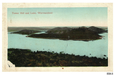 Flagstaff Hill Maritime Museum and Village
Postcard - Scenic, Warrnambool, Tower Hill and Lake, Warrnambool, 1902-1929
... Tower Hill National Park... was declared a National Park, the first in Victoria, preserving native... was declared a National Park, the first in Victoria, preserving native ...The nine postcards in this set were donated together and date to the early 1900s. All but one postcard in this set shows images of Warrnambool, in the Western District of Victoria; the other has a London image. The postcards were all printed in Great Britain according to that country’s postal regulations. The fronts of all cards have titles printed in red. Most of the images on the cards are attributed to photographer Joseph Jordan and belong to the Jordan Series. The back of these cards has an outline for a postage stamp, a vertical dividing line and a heading on each side of the line to separate the Correspondence from the Address. Postcards or ‘correspondence cards’ appeared in Britain in 1894. They were plain cards with a space for the message on one side and an address on the other; regulations didn’t allow anything but the address to be written on the ‘address’ side. In 1902 the British regulations then allowed a picture to be printed on the front and the address on the back, so messages had to be written on the picture side. Soon, the regulations changed and the back was divided for a message and the address. Tower Hill and Lake, Warrnambool – Tower Hill Wildlife Reserve is in the crater of a dormant volcano. In 1892 the area was declared a National Park, the first in Victoria, preserving native animals and Indigenous plants. The rich volcanic soil in the area attracted early settlers including the families of Henry Giles, born at Tower Hill in 1858 and his wife Mary Jane (born Freckleton) born nearby at Cooramook in 1860. Henry and Mary worked in the local area where they also raised their six children. For a time, Henry was employed as a labourer on the Warrnambool Breakwater. Joseph Jordan - Joseph Jordan was born in 1841 in Leicester England. When he was 16 he joined the 7th Queen's Own Hussars and was sent to India at the outbreak of the mutiny. He took part in the relief of Lucknow and remained in India for eleven years. It was during this time that he became interested in photography. He was posted to New Zealand and later came to Victoria, becoming a sergeant major of the Mounted Rifles. In the mid-1880s he came to the Western district where he was responsible for establishing units of the Mounted Rifles in various country towns such as Dunkeld, Mortlake, Panmure, Bushfield, Koroit etc. He resigned from the army in 1889 and set up a professional photography studio in Liebig Street, Warrnambool. He became very well known in the Western District for family photographs, official photographs of local councillors and groups as well as views of local scenery. In 1891 he photographed the wrecked barque ‘Fiji’ at ‘Wrecks Beach’ near Princetown. His business was taken over by his son Arthur around 1917. Joseph was a keen rifle shot and in 1924 he donated the "Jordan Shield" as a prize to the Victorian Rifle Association. He was made a "Life Honorary Member" of the Warrnambool Returned Soldiers League and in 1933 he was recognised as being the oldest living soldier in Victoria. Joseph died in 1935 aged 95.The postcard of Tower Hill and Lake is connected to the location near Warrnambool where many of our early settlers lived and worked. One of these settlers was the Giles family, whose son Henry was born at Tower Hill. His family has donated many Victorian-era items which are now on display at Flagstaff Hill. Tower Hill National Park is the first place in Victoria to be named a National Park. As in the times when coastal trading ships brought passengers and cargo to the Port of Warrnambool, it continues to be a popular place to visit. Joseph Jordan is a significant figure in Warrnambool history as he helped to establish early units of the Mounted Rifles (G Company) in local towns during the late 1880's and later, photographed local scenes, groups and citizens of early Warrnambool.Postcard, one of nine, landscape orientation, coloured print within a rectangle and an impressed line around the image on the front. The picture shows several islands close together with hills around them and bushland in the foreground. There are dead trees amongst the vegetation and a sandy shore at the foot of some of the hills. The lower left corner shows what appears to be two white rails, possibly a lookout fence. There is no correspondence written on the card. The title is printed in red on the front and the back has inscriptions and outlines for a postage stamp. Jordan Series, printed in Great Britain. Front, in red: “Tower Hill Lake, Warrnambool” Back in green: “Jordan Series” “POST CARD” “PRINTED IN GREAT BRITAIN” “For correspondence” “The Address only to be written here”flagstaff hill maritime museum, flagstaff hill maritime village, flagstaff hill maritime museum and village, maritime museum, warrnambool, great ocean road, warrnambool and district, warrnambool scenes, local scenes, views of warrnambool, joseph jordan, jordan series, jordan photography, postcard, souvenir, correspondence, cameo postcard, tower hill, tower hill national park, victoria's first national park, henry giles, mary jane freckleton, breakwater, early settlers -
 Eltham District Historical Society Inc
Photograph, Monash Bridge, Arthurs Creek Road, Hurstbridge, Eltham Heritage Tour, 24 May 1992, 24/05/1992
... and scrubby understorey, the Kinglake National Park, before more open... National Park, before more open country with deciduous trees ...ELTHAM HERITAGE TOUR The Society excursion on 24th May 1992 was arranged by David Bick, leader of the team carrying out the Shire's heritage study. David selected a number of sites or buildings identified in the study, some of them lesser known components of the Shire's heritage. The tour commenced at the Eltham Shire Office at 10.00 am. Travel was by private car and mini-bus with stops at about twelve locations for commentary by David.It included a short walk in Hurstbridge and lunch at Kinglake. Highlights of the tour included: - 10 am Leave from Shire Offices - 3 Important Trees - A Physical Link to Eltham's First Settlers - Toorak Mansion Gates - A Surviving Farm House - An Intact Circa 1900 Main Street - First Settlers - Gold Miners, and Timber-getters - An Early Hotel - A Pioneering Homestead - Changing Eltham Shire - 20th Century - 4 pm Afternoon Tea and Finish Tour Extract from ELTHAM CULTURAL HERITAGE TOUR (Newsletter No. 85, July 1992, by Bettina Woodburn) "On the Arthurs Creek Road is a bridge designed by Monash, which we admired before walking across the little park with a mud-brick and timber shelter, to the Hurst family graveyard. There are two marked graves, one, Henry who was shot by Burke the bushranger and a cairn has a plaque listing others buried here from 1866 onwards. Burke was captured and tied to the wheel of a dray under the eucalypt near the waterhose/standpipe. Close by the kindergarten, at this place are three trees on the National Trust Register, a Canary Island pine, a Canadian cedar and probably a spruce. Radiata pines and a thick bolled peppercorn surround the little cemetery. Continuing along Main Street we notice elm trees planted as a war memorial, then on the left a 1930 timber house, a 1910 store and residence, resplendent with wrought iron trim, a double fronted Hardware Store and cypresses on the back alignment of a new vacant block. On the right side of the street is a less interesting attempt at an 'in character' shop. Further on are more early homes, one tucked away at the rear with two tall palms by the front steps. Another curiosity is a rounded veranda corner and there are more galvanised iron sheds or garages, before a mud-brick Dentist's Surgery. Beyond the round-a-about is St Peters Church, of mud-brick construction shared by Catholic and Anglican parishioners, overlooking the river flood plain. Leaving Hurstbridge on the Kinglake Road, we ate our picnic lunch beside the communication tower and enjoyed views of Melbourne, Yan Yean Reservoir and the distant Dandenongs beyond the spreading suburbs. Next we drove to the North West boundary of the Shire at Masons Falls Road towards Whittlesea. On the way to the North East Boundary we passed St Peters, a yellow wooden Church with a Tudor Archway; built in the early 1920's in the style of the 1860's. From the Healesville-Kinglake road the rolling hills had European aspects, the hedged fields and chestnut trees. Then it was back down the Hurstbridge Road through 'Aussie' bush of towering gums, with bracken and scrubby understorey, the Kinglake National Park, before more open country with deciduous trees planted in line, and a creek lined with willows."Record of the Society's history and activities and highlighting various aspects of the Heritage Study undertaken by David Bick used to create the future heritage overlay for the Shire of Eltham and later Nillumbik Shire.Roll of 35mm colour negative film, 4 stripsKodak Gold 100 5095shire of eltham historical society, activities, heritage tour, hurstbridge, monash bridge, arthurs creek road