Showing 1360 items matching "parks and reserves"
-
 Eltham District Historical Society Inc
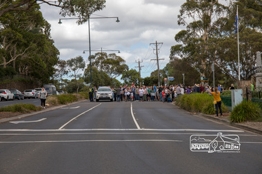
Photograph, The head of the march by some 3,000 people, Save Community Reserves Rally, Main Road, Eltham, 4 March 2018, 4/3/2018
... Reserves Rally, Main Road, Eltham, 4 March 2018...parks ...Protest rally against Nillumbik Shire Councillors' proposal to sell off 17 community reserves. Held at the site of the former Shire of Eltham offices, at 895 Main Road, which were demolished in August 1996, followed by a march along Main Road finishing at the Eltham Railway Station car park at Luck Street. Estimated attendance was approximately 3,000.Born digital image (9)nillumbik shire council, parks, save community reserves, protest rally -
 Eltham District Historical Society Inc
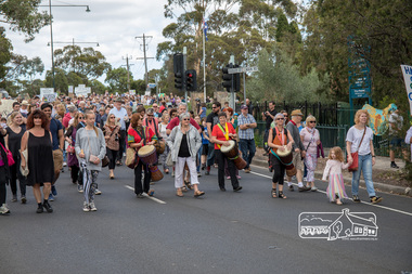
Photograph, Percussion accompaniment at the head of the march, Save Community Reserves Rally, Main Road, Eltham, 4 March 2018, 4/3/2018
... Community Reserves Rally, Main Road, Eltham, 4 March 2018...parks ...Protest rally against Nillumbik Shire Councillors' proposal to sell off 17 community reserves. Held at the site of the former Shire of Eltham offices, at 895 Main Road, which were demolished in August 1996, followed by a march along Main Road finishing at the Eltham Railway Station car park at Luck Street. Estimated attendance was approximately 3,000.Born digital image (3)nillumbik shire council, parks, save community reserves, protest rally -
 Eltham District Historical Society Inc
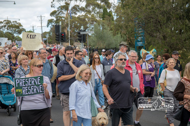
Photograph, Save Community Reserves Rally, Main Road, Eltham, 4 March 2018, 4/3/2018
... Save Community Reserves Rally, Main Road, Eltham, 4 March...parks ...Protest rally against Nillumbik Shire Councillors' proposal to sell off 17 community reserves. Held at the site of the former Shire of Eltham offices, at 895 Main Road, which were demolished in August 1996, followed by a march along Main Road finishing at the Eltham Railway Station car park at Luck Street. Estimated attendance was approximately 3,000.Born digital image (58)nillumbik shire council, parks, save community reserves, protest rally -
 Eltham District Historical Society Inc
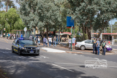
Photograph, The end of the march along Main Road at the Eltham Railway Station carpark, Luck Street, Save Community Reserves Rally, Main Road, Eltham, 4 March 2018, 4/3/2018
... Station carpark, Luck Street, Save Community Reserves Rally, Main...parks ...Protest rally against Nillumbik Shire Councillors' proposal to sell off 17 community reserves. Held at the site of the former Shire of Eltham offices, at 895 Main Road, which were demolished in August 1996, followed by a march along Main Road finishing at the Eltham Railway Station car park at Luck Street. Estimated attendance was approximately 3,000.Born digital image (6)nillumbik shire council, parks, save community reserves, protest rally -
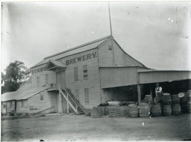 Stawell Historical Society Inc
Photograph, Brewery Building of the Stawell Brewery originally owned by Thomas Powell and later Bryant and Co in Stawell West near the Botanical Reserve
Wooden Brewery Building Stawell Brewery originally owned by Thomas Powell and later Bryant and Co. Located Stawell West near the Botanical Reserve. Closed about 1918. where there are scores of Hotels common sense says "Build a Brewery" and share the takings. Stawell Brewery was situated in part of the present Caravan Park. Almost opposite the entrance to the RacecourseTwo Story wooden Building with additions to left. A Man sitting on Barrels to the right.Stawell Breweerystawell, stawell brewery -
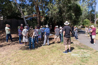 Eltham District Historical Society Inc
Photograph, Peter Pidgeon, Heritage Excursion: Woodridge Wander, 6 March 2021
The Woodridge Estate was a major residential subdivision that was developed in many stages in the 1970s and 80s. It extended easterly from the older residential area of Eltham into what had previously been largely privately owned bushland. The subdivision design took into account the steep topography and resulted in large blocks that enabled preservation of much of the tree cover. It included a number of small parks and walkways and the one kilometre long Woodridge Linear Park. A bushland area left as a proposed school site later became the Pauline Toner Butterfly Reserve for preservation of the rare Eltham Copper Butterfly. This walk explores some Woodridge streets as well as the linear park and butterfly reserve, a hilly walk of about 3 km and includes some moderately rough tracks. Permission to visit the external grounds of two private properties to view heritage listed houses not visible from the street was granted. The walk commenced at 2pm at the access to Woodridge Linear Park in Grove Street just east of the Eltham East Primary School (Melway ref 22 B4). This free walk was open to the general public as well as Society members. Whilst COVID restrictions did not require the wearing of masks in the open, masks had to be carried and all attendees registered with name and contct number.Born Digital (41 images)covid-19, eltham, eltham district historical society, heritage excursion, woodridge estate -
 Greensborough Historical Society
Map, Heidelberg: Historic River Landscape Assessment. Historical maps. Map E 1901-1934 "A Time of projects and improvements", 1985c
Geographical area of around 35 sq. kilometres marked with physical features such as major roads, railways (new extension to Eltham), rivers and properties, also housing sub-divisions and community facilities such as hospitals, parks and sporting reserves and indications of new small scale industries such as dairying. Bounded by Shire of Diamond Valley to the North, Darebin Creek to the West and Plenty River to the East. Black and white sketch map on white paperheidelberg, heidelberg - maps -
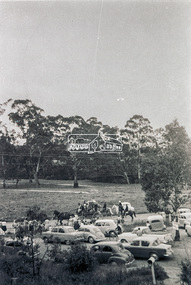 Eltham District Historical Society Inc
Slide - Photograph, Possibly the Ersilac Parade travelling along Main Road, Eltham, c.1958
View from Grace Mitchell's shop at the corner of Mount Pleasant Road and Main Road. Grace Mitchell was probably best known for her Eltham shop at the corner of Mt Pleasant Road and Main Road. Grace's memories covered many local identities who were patrons of her shop between 1954 and 1971. From the elevated position of her shop and home Grace was able to view a varied passing parade of Eltham events from ERSILAC, Easter and Eltham Festival parades passing on their way to Eltham Lower Park, circuses in Wingrove Park (then Bremner’s Reserve), roadworks and other happenings. Bremner's Reserve was renamed Wingrove Park c.1970 This photo was from a series of images presented by Grace Mitchell at a Society talk 10 March 1993 on the theme of “My Eltham”. Alistair Knox had one of the first VW Beetles in Eltham; perhaps the one shown is his. This model has a large rear window, first introduced in 1958. The Holden ute could be an FC or FE. The FE was produced July 1956-April 1958 and the FC May 1958-January 196035mm Kodak 5052 TMX Black and White transparency, 1 strip, 6 frames Black and white print 17 x 25.4 cmcars, bremner's flat, eltham, ersilac parade, main road, mount pleasant road, wingrove park, festival, horse drawn carriage -
 City of Kingston
Map - Parish of Moorabbin
Warning: This object includes historical language referring to First Nations Peoples which is no longer appropriate but has been recorded for historical purposes. Produced in 1853, this map shows the land holdings of European families. While the majority of holdings are small there are also large land holdings as can be seen with Henry Dendy's Special Survey. Of particular note is the "Reserve for Aborigines" which was established in approximately 1841 and consisted of over 830 acres. This area is the current location of Mordialloc township and Attenborough Park, in Mordialloc, is the last remnant of the reserve. An Alfred Sikes, possibly the surveyor/cartographer who drew this parish plan, purchased land in Berwick in 1854.A handrawn map on fabric, with blue markings representing the coastline to Port Phillip Bay, red markings representing a proposed train line to Mordialloc, major roads and street, as well as a "Reserve for Aborigines", which constituted approximately 830 acres. In the bottom right hand corner, the map has been signed and dated.Handwritten in ink: Alfred Sikes / 38 Collins St East / June. 1853moorabbin, mordialloc, dendy, port phillip bay, aboriginal reserve, attenborough park -
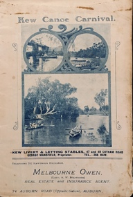 Kew Historical Society Inc
Programme, Kew Canoe Carnival, 1910
An item from an outstanding and diverse photographic collection, assembled by members of the Christian and Washfold families of Kew.Rare programme for what was once an annual event in Kew with important, possibly unique photos of sites in Kew and on the Yarra.Programme for the 1910 Kew Canoe Carnival which was held on the River Yarra on February 11th. The location was at the Asylum Reserve at the old white bridge (the precursor of Kane's Bridge). Funds were raised in Aid of the Annual Treat to Kew and Yarra Bend Patients (and the Carnival fund). The booklet includes details of the programme, numerous advertisements and rare and important historic photographs of the district including: the Willsmere Park Dairy, the Glen Tea Gardens at Hawthorn, the Pipe Bridge, the Kew Boat Sheds (Macauley's), and Rudder Grange boat house.christian-washfold collection, kew canoe club, kew canoe carnivals -
 Eltham District Historical Society Inc
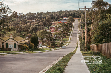
Photograph, Fred Mitchell, Looking east along Arthur Street just down from intersection with Bible Street, Eltham, 1968, 1968
Valiant is parked outside what was no. 43 now part of a unit complex at no. 41. Immediately in front of Valiant is no. 45, which has been a vacant block since before 1990. Gentleman in hat with paper walking up hill is outside no. 39, now a unit complex and the old house on left is no. 37 (since replaced) which borders what is now the Walter Withers ReserveDigital copy of colour photographfred mitchell collection, 1968, bible street, arthur street, eltham, houses, streets -
 Eltham District Historical Society Inc
Photograph, Liz Pidgeon, Heritage Excursion; Eltham Lower Park Walk and Talk, 1 July 2017, 1 July 2017
Information board: Hohnes Hill Flora & Fauna Reserve produced by Shire of Nillumbik and Parks Victoria which includes text and images with references to the Eltham Copper Butterfly. Newsletter No., 234, June 2017 Heritage Excursion - Saturday 1st July - Eltham Lower Park - Walk and Talk Eltham Lower Park has played an important part in the history of our area since the early days of European settlement when it was used by local residents as an informal racecourse. Prior to that its location at the junction of the Diamond Creek and the Yarra River made it an important meeting place for the Wurundjeri people. The park combines formal elements and sporting facilities with remnant bushland that is of environmental significance. It is home to sporting and horse riding clubs, popular play spaces and the Diamond Valley Miniature Railway, which attracts large numbers of visitors. The park will be the venue for our July excursion which will comprise a walk of about 3.5 km around the park and adjacent areas. Along the way we will discuss the history and natural history of the area. The path along the creek and the river provides a pleasant and scenic walk. This walk on Saturday 1st July is about 3.5 km in length and will take 2 to 2.5 hours. It will start at 2pm at the Main Road car park at the front of the park. (Melway ref 21 H 10). Born Digitalheritage excursion, activities, eltham district historical society, eltham lower park, hohnes hill, reserve, eltham copper butterfly, sign -
 University of Melbourne, Burnley Campus Archives
Plan, [Historical Maps of Richmond Park], 1862-2000
(1) Proposed reserve for Horticultural & Experimental Garden in the Survey paddock Richmond. R.19A (1865). Shows Swan Street Extension. Gazettals 1877, 1887. (2) As (1). Half of map only Annotation by A. Purchas, 9 October, 1862. (3) Plan of Richmond park. A.L. Martin Authorised Surveyor, 31st August, 1872. [Dept. of lands & Survey Melbourne, J. Noone, 6th September 1872.] Map in 4 sheets. (4) Richmond Park. Surveyed by Geo. Black, Authorised Surveyor 13.8.91 (2 copies). (5) [Richmond Park] Shows road alignments gazetted 1871 & 1881 (part copy only - Neg. 18375). (6) City of Richmond Parish of Jika Jika County of Bourke. Department of lands & Survey, 1919 (annotations i.e. Melb. City Link, Amrad, etc. to 1994.) (7) Burnley gardens, 2000. Produced by P. Tulk, Institute of Land & Food Resources, Burnley College, 2000 (re area proposed for heritage listing.)richmond park, survey paddock -
 Kew Historical Society Inc
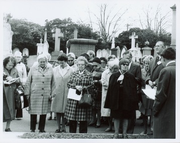
Photograph - Tour of the Boroondara (Kew) General Cemetery, 1977
Boroondara Cemetery, established in 1858, is within an unusual triangular reserve bounded by High Street, Park Hill Road and Victoria Park, Kew. By the 1890s, the Boroondara Cemetery was a popular destination for visitors and locals admiring the beauty of the grounds and the splendid monuments. The Boroondara Cemetery is of historical significance for the graves, monuments and epitaphs of a number of individuals whose activities have played a major part in Australia's history. They include the Henty family, artists Louis Buvelot and Charles Nuttall, businessmen John Halfey and publisher David Syme, artist and diarist Georgiana McCrae, actress Nellie Stewart and architect and designer of the Boroondara and Melbourne General Cemeteries, Albert Purchas.Walking tour led by Kew Historical Society members for members of the Royal Historical Society of Victoria in 1977. The photograph shows members of both parties assembled at a grave in the Cemetery. The photograph was one of six taken by KHS member Stewart West on that occasion, and subsequently donated by him to the collection by him.Reverse: "Front row in dark coat and glasses - Mrs Mills, With dark glasses reading - Mrs Ekberg (KHS member); Second from right Mr Slattery then president of Society; Far left Miss B Mackie (KHS member)" boroondara general cemetery, kew cemetery, walking tours -
 Kew Historical Society Inc
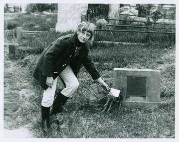
Photograph - Tour of the Boroondara (Kew) General Cemetery, 1977
Boroondara Cemetery, established in 1858, is within an unusual triangular reserve bounded by High Street, Park Hill Road and Victoria Park, Kew. By the 1890s, the Boroondara Cemetery was a popular destination for visitors and locals admiring the beauty of the grounds and the splendid monuments. The Boroondara Cemetery is of historical significance for the graves, monuments and epitaphs of a number of individuals whose activities have played a major part in Australia's history. They include the Henty family, artists Louis Buvelot and Charles Nuttall, businessmen John Halfey and publisher David Syme, artist and diarist Georgiana McCrae, actress Nellie Stewart and architect and designer of the Boroondara and Melbourne General Cemeteries, Albert Purchas.Walking tour led by Kew Historical Society members for members of the Royal Historical Society of Victoria in 1977. The photograph shows a Kew youth placing a sprig of Rosemary on Ellen Quick's grave. The photograph was one of six taken by KHS member Stewart West on that occasion, and subsequently donated by him to the collection by him.Reverse: "Kew youth placing a sprig of rosemary on grave of Ellen Quick nee Derrick who was the first burial on 12/3/1859. Her family Derricks were early Kew Landowners." boroondara general cemetery, kew cemetery, walking tours, ellen quick, dannock family, kew pioneers -
 Ithacan Historical Society
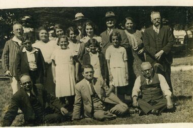
Photograph, Picnic group, c late1930s
The group gathered for the photograph were enjoying themselves at an annual Ithacan Picnic during the 1930s. The picnic was most likely held at Maddingley Park, Bacchus Marsh as it was the regular site for the picnic up until 1980 following which a move was made to the Ferny Creek Reserve, now the regular venue. Notable from early picnic photos is the effort that was made to dress for the picnic; men in suits and women in smart outfits.A black and white photograph of people standing in an sports ground. There are seven men and five ladies as well as three young girls and a boy. Three of the men are sitting in front of the group on the ground. -
 Bendigo Military Museum
Photograph - 4th Field Survey Squadron Adventurous Training Mount Remarkable National Park, SA, 4th Field Survey Squadron Adventurous Training, Mount Remarkable National Park, SA, 1987
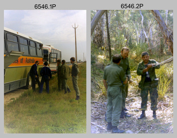
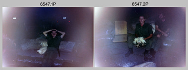
This is a set of 42 photographs of 4th Field Survey Squadron undergoing adventurous training at Mount Remarkable National Park, South Australia in May 1987. It is evident the training focussed on teamwork, leadership, abseiling, rock climbing, field craft and living off the land survival skills. Elements from units of the Army Reserve also participated in the training. Refer to items 6547.40P and 6548.14P for additional photographs taken during the adventurous training.This is a set of 42 photographs of 4th Field Survey Squadron undergoing adventurous training at Mount Remarkable National Park in May 1987. The colour photographs are on 35mm negative film and are part of the Army Survey Regiment’s Collection. The photographs were scanned at 96 dpi. .1) - Photo, colour, 1987. L to R: unidentified bus drivers, CAPT Danny Galbraith, unidentified, SGT Stu Symonds. .2) - Photo, colour, 1987. L to R: OC MAJ Peter Cates, SSM WO1 Bill Grigg, unidentified exchange officer. .3) - Photo, colour, 1987. Squadron briefing. .4) - Photo, colour, 1987. Endurance march L to R: unidentified (x4), LCPL Peter McCurdy, unidentified (x3), SPR Damien Killeen, unidentified. .5) - Photo, colour, 1987. Unidentified personnel taking a break during or at end Endurance march. SPR John Keely at far right. .6) - Photo, colour, 1987. Mount Remarkable National Park terrain. .7) - Photo, colour, 1987. Mount Remarkable National Park terrain. SGT Peter Imeson. .8) - Photo, colour, 1987. Mount Remarkable National Park terrain. CPL Jeff Prince. .9) - Photo, colour, 1987. Camp activities. CPL Dave Irving. .10) - Photo, colour, 1987. Camp activities. L to R: unidentified, SPR Perry Langeberg, unidentified (x2), CPL Neale ‘Tex’ Houston, SPR Steve Ellis. .11) to .13) - Photo, colour, 1987. Mount Remarkable National Park terrain. .14) - Photo, colour, 1987. Camp activities. Unidentified. .15) - Photo, colour, 1987. Camp activities. L to R: PTE P. Simpson, SPR Steve Ellis. .16) - Photo, colour, 1987. Hootchie set-up. Unidentified personnel. .17) - Photo, colour, 1987. Hootchie set-up. .18) - Photo, colour, 1987. Camp activities. Unidentified. .19) - Photo, colour, 1987. Camp activities. L to R: SPR Todd Hayley, CPL Jamie McRae. .20) - Photo, colour, 1987. Camp activities. L to R: unidentified, CPL Neale ‘Tex’ Houston, unidentified. .21) - Photo, colour, 1987. Camp activities. L to R: CPL Dave Longbottom, WO2 Brett ‘Dutchy’ Van Leeuwen. .22) - Photo, colour, 1987. Hootchie set-up. .23) - Photo, colour, 1987. Hootchie set-up. CPL Dave Irving. .24) - Photo, colour, 1987. Mount Remarkable National Park terrain. Possibly OC MAJ Peter Cates. .25) - Photo, colour, 1987. Mount Remarkable National Park terrain. .26) & .27) - Photo, colour, 1987. Hootchie set-up. .28) - Photo, colour, 1987. Camp activities. CPL Roger Graf. .29) - Photo, colour, 1987. Camp activities. Possibly water sterilisation. .30) - Photo, colour, 1987. Camp set-up. Unidentified. .31) - Photo, colour, 1987. Hootchie interior. .32) - Photo, colour, 1987. CAPT Danny Galbraith. .33) - Photo, colour, 1987. Camp activities. L to R: LCPL Peter Tuddenham, SPR Todd Hayley, CPL Dave Longbottom, CPL John Ratcliffe, CPL Dave Irving. .34) - Photo, colour, 1987. Hootchie set-up. .35) - Photo, colour, 1987. Hootchie set-up. CPL Peter Hardy. .36) - Photo, colour, 1987. Camp activities. L to R: unidentified (x2), CPL Peter Hardy, LT Greg Oaten. .37) - Photo, colour, 1987. Camp activities. L to R: SPR Shaun Hynes, LT Geoff ‘GT’ Ford, SPR Bruce Graham, unidentified (x2). .38) - Photo, colour, 1987. Camp activities. L to R: SPR Shaun Hynes, LT Geoff ‘GT’ Ford, unidentified, SPR Bruce Graham, in background - CPL Dave Irving. .39) - Photo, colour, 1987. Hootchie set-up. Unidentified. .40) - Photo, colour, 1987. Camp activities. WO2 Brett ‘Dutchy’ Van Leeuwen. .41) & .42) - Photo, colour, 1987. Camp activities. Results from foraging the forest for food..1P to .42P – There are no personnel identified. ‘1987 ADV TRAINING’ annotated on negatives sleeve.royal australian survey corps, rasvy, 4 fd svy sqn -
 Bendigo Military Museum
Photograph - 4th Field Survey Squadron Adventurous Training, Mount Remarkable National Park, Flinders Ranges, SA, 4th Field Survey Squadron Adventurous Training, Mount Remarkable National Park, SA, 1987
This is a set of 40 photographs of 4th Field Survey Squadron undergoing adventurous training at Mount Remarkable National Park, South Australia in May 1987. It is evident the training focussed on teamwork, leadership, abseiling, rock climbing, field craft and living off the land survival skills. Elements from units of the Army Reserve also participated in the training. Refer to items 6546.42P and 6548.14P for additional photographs taken during the adventurous training.This is a set of 40 photographs of 4th Field Survey Squadron undergoing adventurous training at Mount Remarkable National Park, South Australia in May 1987. The colour photographs are on 35mm negative film and are part of the Army Survey Regiment’s Collection. The photographs were scanned at 96 dpi. .1) - Photo, colour, 1987. Camp activities, unidentified soldier. .2) - Photo, colour, 1987. Camp activities, unidentified personnel. .3) & .4) - Photo, colour, 1987. Hootchie set-up. .5) - Photo, colour, 1987. Camp activities, unidentified personnel. .6) - Photo, colour, 1987. Hootchie set-up. .7) - Photo, colour, 1987. Camp activities. .8) - Photo, colour, 1987. Hootchie set-up, unidentified officer. .9) - Photo, colour, 1987. Camp activities. Results from foraging the forest for food. .10) - Photo, colour, 1987. Camp set-up. .11) - Photo, colour, 1987. Camp activities. .12) - Photo, colour, 1987. Camp activities. L to R: CPL Jeff Prince, unidentified (x3). .13) to .16) - Photo, colour, 1987. Camp activities. .17) & .18) - Photo, colour, 1987. Mount Remarkable National Park terrain. .19) - Photo, colour, 1987. Hootchie set-up. L to R: unidentified, CPL Jeff Prince, SPR Perry Langeberg, unidentified (x3). .20) - Photo, colour, 1987. Camp activities. .21) - Photo, colour, 1987. Camp activities, unidentified personnel. .22) & .23) - Photo, colour, 1987. Camp set-up. .24) - Photo, colour, 1987. Hootchie set-up. .25) - Photo, colour, 1987. Hootchie set-up, unidentified personnel. .26) - Photo, colour, 1987. Camp activities. L to R: CPL Jeff Prince, SPR Steve Ellis, SGT Peter Imeson, CPL Neale ‘Tex’ Houston, SPR Perry Langeberg, unidentified exchange officer, WO2 Russ Larsen. .27) - Photo, colour, 1987. Hootchie set-up. .28) - Photo, colour, 1987. Camp activities. L to R: SPR Bruce Graham, LT Geoff ‘GT’ Ford, CPL Jamie ‘Fish’ McRae, SGT Wally Chilcott, SPR Shaun Hynes, CPL Kevin Whitty. .29) - Photo, colour, 1987. Camp activities. L to R: unidentified, SPR Todd Hayley, unidentified, WO2 Peter Symmans, SSGT Cam Chapman, CPL Dave Irving. .30) - Photo, colour, 1987. Camp activities. L to R: unidentified (x2), LT Greg Oaten, unidentified (x2), CPL Peter Hardy, unidentified. .31) - Photo, colour, 1987. Camp activities. L to R: CPL Roger Graf, WO2 Bob Rogister, SSM WO1 Bill Griggs, unidentified officer, SPR Simon Reynolds, SPR John Keely. .32) - Photo, colour, 1987. Camp activities. L to R: unidentified, SPR Steve Nokes, SGT Stu Symonds, WO2 Brett ‘Dutchy’ Van Leeuwen, unidentified (x3). .33) - Photo, colour, 1987. Camp activities. L to R: unidentified, SGT Derek Stanmore, CAPT Danny Galbraith, unidentified in foreground. .34) - Photo, colour, 1987. Camp activities. L to R: unidentified (x3), SGT Derek Stanmore, CAPT Danny Galbraith. .35) - Photo, colour, 1987. Camp activities. .36) - Photo, colour, 1987. Camp activities. OC MAJ Peter Cates. .37) - Photo, colour, 1987. Camp activities. L to R: unidentified, CPL Dave Longbottom. .38) - Photo, colour, 1987. Camp activities, unidentified personnel. .39) & .40) - Hootchie set-up..1P to .40P – There are no personnel identified. ‘1987 ADV TRAINING’ annotated on negatives sleeve.royal australian survey corps, rasvy, 4 fd svy sqn -
 Whitehorse Historical Society Inc.
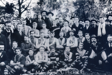
Photograph, Mitcham Football Club, 1904
The Mitcham Football Club was established in 1888. Known as the 'Tigers', their colours are black and yellow and their home ground is at Walker Park, Mitcham. Originally the club played on the Reporter and District League where they won premierships in 1904, 1905, 1914, 1915 and 1921, then in the Eastern Suburbs Football League they won a premiership in 1947. At present (2015) they compete in the Eastern Football League and filed senior, reserves, under 19's and 6 junior Teams.Black and white photograph of the Mitcham Football team and supporters taken outside in1904.Mitcham F.C Premises is written on the bottom of photographmitcham football club, sporting clubs, football clubs -
 Federation University Historical Collection
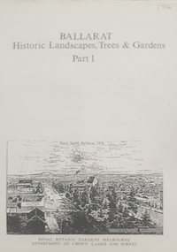
Book, Peter Lumley et al, Ballarat: Historic Landscapes, Trees & Gardens, 1983, 1983
Lisa Green and Lisa Morcom of Ballarat College of Advanced Educatiion contributed to this report.275 page landscape study of Ballarat including Trees in the Victorian Landscape; Plant sources early Ballarat nurseries, Botanical Gardens, Lake Wendouree, Fairy Gardens, Victoria Park, Ballaarat Old Cemetery, Eastern Oval, City Oval, Ballarat East Town Hall Gardens, Eureka Stockade, Observatory, Yarrowee, Black Hill, Sovereign Hill, Cheek Channels, Canadian Creek, Poverty Point Reserve, Goldmining Relics, Woah Hawp, Buninyong, street plantings, Russell, Victoria, Bridge Mall, Sturt Street Gardens, Avenue of Honour, Webster, Elms, ballarat, trees, nursery, r.u. nicholls, francis moss, ballarat botanical gardens, victoria park, lake wendouree, ballaarat old cemetery, eastern oval, ballarat east town hall gardens, ballarat school of mines botanical gardens, eureka stckade recreation reserve, ballarat observatory, yarrowee creek, black hill reserve, sovereign hill, ballarat avenue of honour, victoria street plantings, bridge mall plantings, george longley -
 Whitehorse Historical Society Inc.
Photograph - Black and white photograph, War Memorial Mitcham, C1930
Black and white photo of War Memorial in Whitehorse Road,Mitcham.The much travelled (located and relocated) soldier has been placed n many since the end of WW1:|1. Centre of Whitehorse Road within reserve midway between Mitcham Road and Station Street |2. Closer to Mitcham Road and on the garden /lawns between Whitehorse Road (main throughway) and the northern service| road. 3. On his pedestal outside the Memorial Hall on the corner of Whitehorse Road and MacDowall Street.|4. Currently mounted in the gardens of Halliday Park in Mitcham Rd.war memorial mitcham, whitehorse road -
 Bendigo Historical Society Inc.
Map - HUSTLER'S ROYAL RESERVE NO 2 (PARK SHAFT.) - TRANSVERSE SECTION OF THE HUSTLER'S ROYAL RESERVE NO 2
Transverse section of the Hustler's Royal Reserve, No 2 (Park Shaft.) on the Hustler's Line of Reef. Bulletin No 33, Plate No IX. Section shows poppet legs and sill of shaft at 755.70 ft above sea level, depth of levels, type of stone encountered including lava and geological features. Geological Survey of Victoria emblem and beneath it H. Herman, Director, W. Dickson, Secretary of Mines and The Hon. J. Drysdale Brown MLC Minister of Mines and signed by H S Whitelaw, Underground Survey Office, Bendigo September 1913.mining, parish map, hustler's royal reserve no 2 (park shaft.), h s whitelaw, underground survey office bendigo, geological survey of victoria, h herman, w dickson, the hon j drysdale brown mlc, hustler's line of reef -
 Kew Historical Society Inc
Plan, J R Mathers & McMillan, 5 Splendid vVlla Allotments,: Segtoune St. & Windsor St., Kew, 1928
Prue Sanderson, in her groundbreaking ‘City of Kew Urban Conservation Study : Volume 2 - Development History’ (1988), summarised the periods of urban development and subdivisions of land in Kew. The periods that she identified included 1845-1880, 1880-1893, 1893-1921, 1921-1933, 1933-1943, and Post-War Development. These periods were selected as they represented periods of rapid growth or decline in urban development. An obvious starting point for Sanderson’s groupings involved population growth and the associated economic cycles. These cycles also highlighted urban expansion onto land that was predominantly rural, although in other cases it represented the decline and breakup of large estates. A number of the plans in the Kew Historical Society’s collection can also be found in other collections, such as those of the State Library of Victoria and the Boroondara Library Service. A number are however unique to the collection.Subdivision plans are historically important documents used as evidence of the growth of suburbs in Australia. They frequently provide information about when the land was sold on which a built structure was subsequently constructed as well as evidence relating to surveyors and real estate and financial agents. The numerous subdivision plans in the Kew Historical Society's collection represent working documents, ranging from the initial sketches made in planning a subdivision to printed plans on which auctioneers or agents listed the prices for which individual lots were sold. In a number of cases, the reverse of a subdivision plan in the collection includes a photograph of a house that was also for sale by the agent. These photographs provide significant heritage information relating house design and decoration, fencing and household gardens.In 1928, five residential allotments bordering Segtoune and Windsor Streets were advertised for sale as part of a subdivision. Four of the blocks faced Segtoune Avenue. The auctioneers proclaimed the advantages of the sites: ‘Situate one minute from the High Street Electric Tram, which now runs direct to Spencer Street via Bridge Road and Flinders Street. Opposite the East Kew Railway Station (Outer Circle Line), which may be reopened In connection with the new Line from Kew to Doncaster; Adjacent lo the Kew Recreation Reserve, Sports Oval, and Swimming Bath; Half Minute from the Shopping Centre of East Kew, Accessible to the State School and Other Educational Centres’. The Harp of Erin Hotel and the route of the Outer Circle Railway line are marked on the plan. The Recreation Reserve and Sport Oval refer to Victoria Park. The Swimming Baths were located on the site of the current Kew Recreation Centre.subdivision plans - kew, segtoune street -- kew (vic.), windsor street -- kew (vic.) -
 The Beechworth Burke Museum
Photograph, Unknown
Aerial view of Lake Sambell, Beechworth with town views. Lake Sambell is a beautiful Victorian recreation lake and urban park with a unique history. It was created in the mid-1800s by the Rocky Mountain Mining company during the gold rush era and used as a mining site until the early 1900s, which brought Europeans into the area. It was turned into a reserve for residents in 1920 and is considered an icon of Beechworth as it represents the development of the community, human endeavour, and the spirit of the landscape.This photograph represents Lake Sambell with town views.Black and white reproduced rectangular photograph print on paper.Reverse: Stampbeechworth lake, lake sambell, aerial photo, construction, australian landscape, #beechworth, victoria -
Port Melbourne Historical & Preservation Society
Photograph - Friends of the Park float, Port Melbourne Festival, Pat Grainger, Feb 1989
This float was created by members of Friends of the Park, a group formed in 1987 against government proposals to turn the railway and reservation into a grand boulevard to service the proposed Sandridge City 'bayside' development. Members worked for months to make the decorations, added to a trailer. During the festival procession sausages were BBQ'd on the trailer and handed out to the crowd. On arrival at Murphy's Reserve all floats were put out of sight, and few saw the results of their efforts.One of 16 colour photos of Friends of the Park float for the February 1989 Port Melbourne Festival: Nellie Thackruh, Jan Fly and Andrea Ellis in background, finishing preparations in Raglan Streetcelebrations fetes and exhibitions, public action campaigns, jan fly, andrea ellis, nellie thackruh, friends of the park, port melbourne festival -
Port Melbourne Historical & Preservation Society
Photograph - Friends of the Park float, Port Melbourne Festival, Pat Grainger, Feb 1989
This float was created by members of Friends of the Park, a group formed in 1987 against government proposals to turn the railway and reservation into a grand boulevard to service the proposed Sandridge City 'Bayside' development. Members worked for months to make the decorations, added to a trailer. During the festival procession sausages were BBQ'd on the trailer and handed out to the crowd. On arrival at Murphy's Reserve all floats were put out of sight, and few saw the results of their efforts.One of 16 photos of Friends of the Park float for the February 1988 Port Melbourne Festival: Float construction at Station Street carport, 88 Ingles Street: Jan Fly and ?celebrations fetes and exhibitions, public action campaigns, town planning - proposals shelved - bayside, jan fly, friends of the park, port melbourne festival -
Port Melbourne Historical & Preservation Society
Photograph - Friends of the Park float, Port Melbourne Festival, Pat Grainger, Feb 1989
This float was created by members of Friends of the Park, a group formed in 1987 against government proposals to turn the railway and reservation into a grand boulevard to service the proposed Sandridge City 'bayside' development. Members worked for months to make the decorations, added to a trailer. During the festival procession sausages were BBQ'd on the trailer and handed out to the crowd. On arrival at Murphy's Reserve all floats were put out of sight, and few saw the results of their efforts.One of 16 photos of Friends of the Park float for the February 1989 Port Melbourne Festival: Float construction at Station Street carport, 88 Ingles Street: ?, Gary Ways (L), Amelia Finch (C), Anne Callaghan(R)celebrations fetes and exhibitions, public action campaigns, anne callaghan, gary, amelia finch, friends of the park, port melbourne festival -
Port Melbourne Historical & Preservation Society
Photograph - Friends of the Park float, Port Melbourne Festival, Pat Grainger, Feb 1989
This float was created by members of Friends of the Park, a group formed in 1987 against government proposals to turn the railway and reservation into a grand boulevard to service the proposed Sandridge City 'Bayside' development. Members worked for months to make the decorations, added to a trailer. During the festival procession sausages were BBQ'd on the trailer and handed out to the crowd. On arrival at Murphy's Reserve all floats were put out of sight, and few saw the results of their efforts.One of 16 photos of Friends of the Park float for the February 1989 Port Melbourne Festival: Float construction at 88 Ingles Stcelebrations fetes and exhibitions, public action campaigns, town planning - proposals shelved - bayside, anne callaghan, gary way, friends of the park, sandridge city development co pty ltd, scdc, port melbourne festival -
Port Melbourne Historical & Preservation Society
Photograph - Friends of the Park float, Port Melbourne Festival, Pat Grainger, Feb 1989
This float was created by members of Friends of the Park, a group formed in 1987 against government proposals to turn the railway and reservation into a grand boulevard to service the proposed Sandridge City 'bayside' development. Members worked for months to make the decorations, added to a trailer. During the festival procession sausages were BBQ'd on the trailer and handed out to the crowd. On arrival at Murphy's Reserve all floats were put out of sight, and few saw the results of their efforts.One of 16 photos of Friends of the Park float for the February 1989 Port Melbourne Festival: Float construction at Station Street carport - Jemma and Marilyn Tulloch with flower decorationscelebrations fetes and exhibitions, public action campaigns, gemma tulloch, marilyn tulloch, friends of the park, port melbourne festival -
Port Melbourne Historical & Preservation Society
Photograph - Friends of the Park float, Port Melbourne Festival, Pat Grainger, Feb 1989
This float was created by members of Friends of the Park, a group formed in 1987 against government proposals to turn the railway and reservation into a grand boulevard to service the proposed Sandridge City 'bayside' development. Members worked for months to make the decorations, added to a trailer. During the festival procession sausages were BBQ'd on the trailer and handed out to the crowd. On arrival at Murphy's Reserve all floats were put out of sight, and few saw the results of their efforts.One of 16 photos of Friends of the Park float for the February 1989 Port Melbourne Festival: Preparations for the procession forming by the Raglan Street flats - Gary Way (L), Michaela Sammit, Marilyn and Gemma Tulloch.celebrations fetes and exhibitions, public action campaigns, gemma tulloch, marilyn tulloch, jan fly, michaela sammit, gary, friends of the park, port melbourne festival