Showing 255 items
matching railway platform
-
 Ballarat Tramway Museum
Photograph - Digital image, W. J. Llewelyn, late 1960s
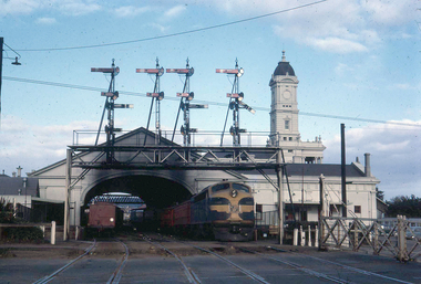
Set of three colour digital images taken by W. J. Llewelyn of the Ballarat Railway Station at Lydiard St North. .1 - Possibly a S class loco on the Horsham / Dimboola/Serviceton St, about to leave Ballarat station during the late 1960's or early 1970's. A freight train is on platform 2. Note the Parcels Office and that the clock had not been fitted to the station building. .2 - S305? shunting at Ballarat station, during the late 1960's or early 1970's. Photos taken from the signal box. .3 - R766 on a special train at the station - late 1980's. Has the failed Melbourne - Canberra - Sydney tourism venture carriages at the rear.trams, tramways, railway station, level crossings, lydiard st north, steam locomotive -
 Ballarat Tramway Museum
Slide - 35mm slide/s, Keith Caldwell, 12/03/1962 12:00:00 AM
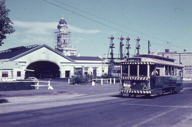
Yields information about the nature of tram services and trams in Lydiard St North and the Railway Station.Agfa colour slide, white cardboard mount, photo by Keith Caldwell on 12/3/1962 of: Tram 13 northbound in Lydiard St North, with the railway station and Reid's Coffee Palace in the background. The station clock tower has scaffolding around it. An Orlando wine advertisement is visible on the platform along with signal gantry. The Tram has an Age advertisement.In ink "Ballarat 12.3.62"tramways, trams, railway station, lydiard st north, tram 13 -
 Ballarat Tramway Museum
Slide - 35mm slide/s, Peter Moses, Jan. 1969
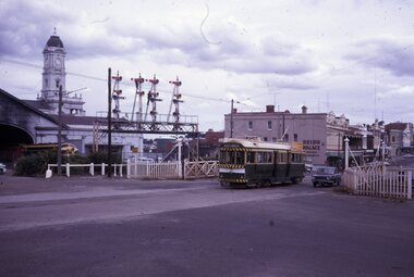
Photo of SEC Ballarat No.41 passing through the railway gates at Ballarat Railway Station, Lydiard St. North, with the destination of "Lydiard St Nth". Tram has a SEC "Everything's under control in my all-electric kitchen". Reid's Coffee Palace is in the background. Photo shows the Ballarat Railway Station clock tower, part of the train shed and the signals on the station side of the gates. A "B" class locomotive on a passenger train is standing in platform 1 of the station. Kodak cardboard mount slide, taken by Peter Moses assumed Jan. 1969, dated only "Jan", but date lines up with Bendigo slides and type of numbering. Could be 1970.On the rear of the slides in black ink "P. Moses" along bottom left hand corner in black ink.tramways, trams, railway crossing, lydiard st, railway station, reid's coffee palace, tram 41 -
 Ballarat Tramway Museum
Programme, Association of Railway Enthusiasts (ARE), "Official Opening of the Ballarat Tourist Tramway", Jan. 1975
Duplicated sheet on pink coloured quarto size paper, by the Association of Railway Enthusiasts, Excursion to Wendouree, Saturday 1st Feb. 1975, titled "Official Opening of the Ballarat Tourist Tramway". Gives tour details, vehicle to be used - 41DRC, arrangements for trains, photo stops, trams, and that the train would operate from Wendouree Platform. Three copies held.trams, tramways, btps, opening, celebrations, timetables, are -
 Ballarat Tramway Museum
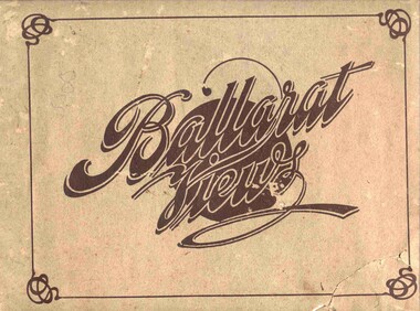
Book, Baxter & Stubbs, "Ballarat Views", 1920's
Yields information about Ballarat through pictures of the 1910-1920's various locations, institutions and street scenes, including tramways and railways.Twenty four page book within light brown covers, titled "Ballarat Views". Sheets, other than covers have been individually printed both sides, stapled within the covers. Cover - gives title, rear cover has printer details - Baxter and Stubbs. Pages 1 - Tonner Memorial , Fountain Lake Wendouree, Ballarat District Hospital, Sturt St south side at Grenville St with tram in distance and Sturt St North Side showing shops (image btm3900i2.jpg). 2 - Ballarat Street Scenes - Sturt Streets, Lydiard St with ESCo 18 in view, and Railway station with R193 in platform on passenger train. (image btm3900i3.jpg). 3 - Lake Wendouree views. 4 - Lake Wendouree, fish hatchery, Gardens and Sturt St at Dawson St (image btm3900i4.jpg). 5 - Art Gallery Ballarat 6 - Botanical Gardens 7 - Public Institution s- Benevolent asylum, Orphanage, Nazareth House, St Joseph Home, Hospital 8 & 9 - Statues, the Flight from Pompeii and others. 10 & 11 - Churches of Ballarat 12 - The Arch at The Avenue of Honour 13 - McDonald Pergola at the Gardens 14 - Zoological Gardens Ballarat 15 - Gardens aerial view and gates at the South End with tram in the distance (image btm3900i5.jpg). 16 - Some views in Ballarat East - Eureka Stockade, Ballarat East Bowling Green, Bridge St looking east and the lake at the Eureka Gardens (image btm3900i6.jpg). 17 - Snow Scene at Botanical Gardens, Begonia House 18 & 19 - Ballarat Water supply reservoirs 20 - Ballarat State Schools 21 - Ballarat East Views, includes view of track in Victoria St looking east (image btm3900i7.jpg). 22 - Views of the Water Reserves 23 - Views about the City - includes City fire station , agricultural High School, City Baths and View Point. 24 - Views at Lake Wendouree. \ Pdf copy of full book added 8/5/2019 - see btm3900i9.pdf trams, tramways, ballarat, lydiard st, sturt st, gardens, railway station, hospital, lake wendouree, wendouree parade, carlton st, esco -
 Ballarat Tramway Museum
Postcard, Ron Scholten, Ballarat No. 18 waiting at the Lydiard St. gates, 1960s
Photo of Ballarat No. 18 waiting at the Lydiard St. gates with the Ballarat station building in the background, and a R class hauled train in No. 2 platform. Shows the signal gantry. No. 18 has the destination of city and has a an auxiliary board advertising a Fete - see also Reg. Item 2020 for 18 with the same sign.Colour photograph, printed on a postcard back format.On the rear in pencil "Ball 18 Railway Stn / Ron Scholten Collection for BTM archives".trams, tramways, railway station, lydiard st nth, tram 18 -
 Ballarat Tramway Museum
Ephemera - Tour Notes, Victorian Railways et al, ARE/ARHS/AREA (Vintage Train) Tour to Ballarat, Sep. 1971
Set of three foolscap size sheets, for ARE/ARHS/AREA (Vintage Train) Tour to Ballarat, on Sunday 5 September 1971, the last day of the Mount Pleasant, Gardens Via St. West Lines. 1. - Welcome Aboard circular - printed both sides on pink paper - which involved the running of two trains, special bus and tram arrangements at Ballarat, for the visit to Sovereign Hill. Gives details of the tram timetables, for the afternoon, train departure times, lunch arrangements and notes on bus and tram running if peak loads encountered. 2nd copy ex Peter Winspur, added 11/1/2007. 2. Victorian Railways S Circular, or special train notice, S2188/71, three pages giving list of special trains, altered platform arrangements at Flinders St., train schedules, alterations to goods trains, light engine movements, loads, motive power and tickets. Signed by J.C. Crute as Chief Traffic Manager. Dated 27/8/1971. See Reg Item 3442 for the booking circular and form. Images of document added 27-08-12.Notes on page 2 by W.Doubleday of trams operating and some notes.arhs, are, area, ballarat, special trains -
 Ballarat Tramway Museum
Slide - 35mm slide/s, Ben Parle, 8/04/1958 12:00:00 AM
Kodachrome Transparency - 35mm slide - cardboard mount, with one side with red border and words "Kodachrome Transparency / Processed by Kodak" top and bottom. Photo taken by Ben Parle 8/4/1958. Has slide No. "16" stamped in red in top corner. Photo of Ballarat No. 42 crossing the rail crossing, Lydiard St. North, Ballarat Railway Station. Taken from the footbridge within the station roof. A K class hauled goods is waiting on platform No. 2 to leave the station. Has the signal gantry and "B" signal box in the background. "Lydiard St Ballarat 8-4-58"tramways, trams, lydiard st, railway, level crossings, ballarat railway station, tram 42 -
 Ballarat Tramway Museum
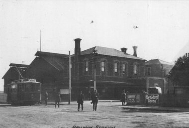
Photograph - Geelong No. 5 at the Railway Station, 1915
... Photo of Geelong No.5 at the Railway Station, c 1915... at the Railway Station, c 1915, Railway station in the background, prior ...Photo of Geelong No.5 at the Railway Station, c 1915, Railway station in the background, prior to the extension and the construction of the awning over No. 1 platform area. Has title "Railway Station" along the bottom edge. In the view are signs for Griffiths teas and Bensdorp Cocoa. On the rear "Geelong Historical Post Card Series No. 9 Railway station with No. 5 Tramcar ready to depart for West Geelong 1915" Publisher not known. See also Reg item 4408 for another reproduction of this photograph. Illustration has been cut from a magazine.Yields information about Geelong Railway Station and tram No. 5 in 1915.Sepia-toned print of a postcard and an illustration of the same photograph.trams, tramways, geelong, railway station, tram 5 -
 Ballarat Tramway Museum
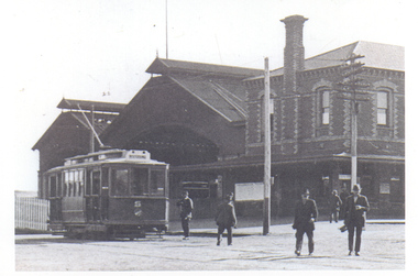
Photograph - Geelong No. 5 at the Railway Station, c1915
Yields information about Geelong Railway Station and tram No. 5 in 1915.Black and white reproduction photograph of Geelong No. 5 at the Geelong Railway station, c 1915, Railway station in the background, prior to the extension and the construction of the awning over No. 1 platform area. Has a number of men walking towards the camera. Print made by scanning the photograph and printing two copies on the same sheet. Printed on "Kodak Picture Maker Paper". See also Reg item 4396 for another reproduction of this photograph.In ink on rear "Hugh Ballment Collection"trams, tramways, geelong, railway station, belmont, tram 5 -
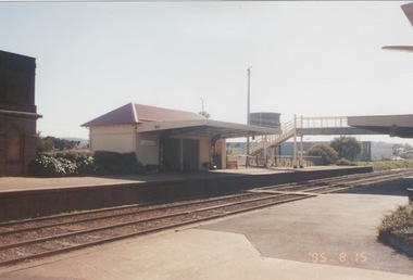
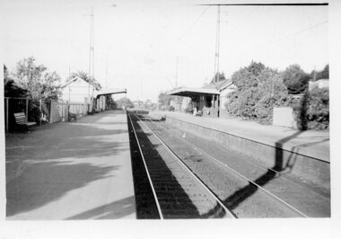
 Ballarat Tramway Museum
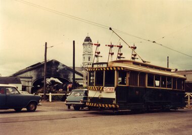
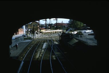
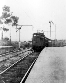
Slide - 35mm slide/s, Dave Simpson, late 1960's early 1970's
... mount of a the view from No. 1 platform at Ballarat Railway... platform at Ballarat Railway Station looking towards the Lydiard St ...Yields information about the Ballarat Railway Station and the adjacent level crossing.Set of two 35mm slides - Hanimex light blue grey plastic mount of a the view from No. 1 platform at Ballarat Railway Station looking towards the Lydiard St level crossing. Shows the crossing gates, signals and tracks. A goods train with a Z van at the rear is in the platform.tramways, trams, railway station, victorian railways -
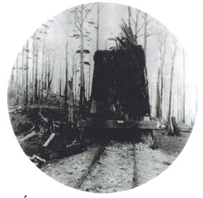
 Otway Districts Historical Society
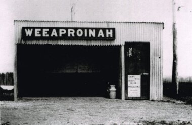
Photograph, R. Preston, Weeaproinah mallee shed, c.1920, c.1920
Originally named 'McInnes' after a local selector, this station opened during construction of the Crowes railway on 1 May 1911. The name was altered to Weeaproinah, the second station of that name, on 9 December 1912, after the parish in which the station was situated. (The original 'Weeaproinah' on the railway became earlier 'Dinmont' in the Olangolah Parish.) The station comprised a passenger shelter and a loop siding with a ramped platform for a sheep and pig race. A departmental residence was built for a track repairer based at the station, but no station or caretaker staff were employed there. The residence was burnt down during the 1919 bushfire but it was replaced and remained in use as a departmental residence until 1930. Weeaproinah became an unattended crossing station in December 1927 under the Train Section Order system.B/W. Weeaproinah mallee shed. In the shed there are five large wall-mounted posters and a cream can. An unlocked door with a "Skins / Hides" poster gives access the inside. A tree trunk stands to the right.weeaproinah; railways; shed; -
 Otway Districts Historical Society
Photograph, Crowes: Terminus of the railway line, 1911
The terminus of the railway, and the southern-most station on the Australian mainland, was Crowes, approximately 2 kilometres from Lavers Hill. The line ended at "The Black Stump". Crowes was designed as a fully functioning terminus and received a complete instalment of facilities. The site was laid out with three roads plus a dead end siding for a locomotive shed and ash pit. Goods sheds, a platform and livestock ramps catered for freight loadings, while on the north side was a station office, waiting room, parcels shed and passenger shelter. Three departmental residences were also provided. The resident Station Master was withdrawn in November 1916 and the station closed with the line on 10 December 1954.Photograph. Terminus of the Colac-Crowes at Crowes.crowes; terminus; "the black stump"; -
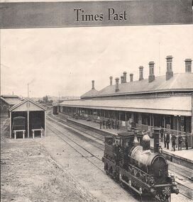 Bendigo Historical Society Inc.
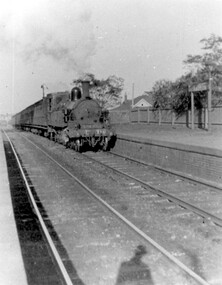
Newspaper - BENDIGO RAILWAY STATION: STEAM TRAIN AT STATION
Cutting from newspaper, unknown source. On top of cutting 'Times Past' Image shows steam engine at Bendigo Railway Station. People standing on platform, steam engine in foreground LH side.bendigo, hospital -
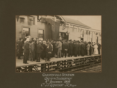 Bayside Gallery - Bayside City Council Art & Heritage Collection
Photograph - sepia photograph, Sears Studios, Opening of Gardenvale Station, 1906
gardenvale, station, train, platform, public transport, opening, crowd, mayor, sears studios, railway, gardenvale station -
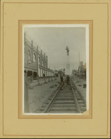 Kew Historical Society Inc
Photograph - Construction of the electric tram line in Glenferrie Road, Glenferrie, E.J. Dower, 1914
One of a series of photographs, taken by Edgar James Dower in the second decade of the twentieth century. Born and raised in Olinda, his family later moved to Surrey Hills. He worked as an adult as a clerk in the city office of the Metropolitan Gas Company, and in his role as a 'collector', he was able to photograph scenes including the construction of tramlines and associated buildings in Kew, Hawthorn, Camberwell and Surrey Hills. Later he established a real estate agency with his brother - the E.J. Dower Real Estate Agency, Dandenong Office.The image is an historically significant record of the development of transport infrastructure which was used to connect Victorians in the first two decades of the twentieth century. This development resulted from increases in population and the consequent extension of Melbourne's suburbs. The photographs, both individually and collectively, richly detail the labour of workers and the tools and machinery used to create and extend Melbourne's public transport network in the years preceding and during World War 1.Digital copy of an original mounted photograph showing a worker standing on a ladder in Glenferrie Road, Hawthorn, working on the overhead electric cables that would be used to power trams on the New Kew tramline.Other railway workers are working on platforms or viewing the man on the ladder. The ladder appears to be only supported by one other worker. "The Don Store" at left is immediately behind the old railway level crossing which can be seen in the distance to the south.Annotated verso: "Preparing for electric trams in Glenferrie Road, near Glenferrie Station, showing railway gates / Taken by E.J. Dower 1914"theme --- travelling by tram, theme -- connecting victorians by transport and communications, glenferrie road -- hawthorn (vic.), railways -- hawthorn -
 Kew Historical Society Inc
Postcard, R McGeehan, The Effect of Storm. Train Passing Through Flood Waters, South Yarra, 25-1-07, 1907
SHARP DOWNPOUR. ONE INCH IN 45 MINUTES. SOUTHERN SUBURBS DELUGED. TRAIN STOPPED AT SOUTH YARRA. One of the sudden downpours of rain which occasionally fall in Melbourne occurred yesterday afternoon, when nearly an inch of rain fell in the course of three quarters of an hour, and caused a flood for an hour or two in certain localities. During the early part of the day, the sky had been clouded over, but there was nothing to indicate a storm of such intensity as that which followed. At about half-past 1 o'clock residents of South Yarra, South Melbourne, Prahran, and St. Kilda noticed a few drops of rain. Still, it appeared unlikely that there would be anything exceptional, until with startling suddenness at about 10 minutes to 1 o'clock, one of the heaviest downpours within the memory of residents burst upon those suburbs. A strange feature of the storm was that it was practically confined to an area of about three miles square. The city was but little affected, though at a spot as close as the Observatory 86 points of rain were recorded in three-quarters of an hour. Thunder and lightning accompanied the downpour, which was cyclonic in character, the rain driving heavily from all points of the compass as the cyclone passed. It was in South Yarra and Prahran that the rain fell heaviest. Within a few minutes after it commenced, the low-lying portions of Toorak-road and practically the whole length of Chapel-street were under water. The depression at the intersection of Toorak-road and Darling-street speedily filled to the dimensions of a small lake. Several shops were inundated, while the water from the higher levels rushed down like a mountain torrent, and in several in-stances swept through the rear of houses and shops, carrying furniture in a floating mass against the further walls. In one case a footbridge was carried bodily away and dashed to pieces. Darling-street itself Great Davis-street, and other low-lying and flat thoroughfares in the vicinity became flooded from kerb to kerb, while on the other side of the railway-bridge the valley between Kensington-road and River-street became filled for some minutes to a depth of several feet. Meanwhile the waters from South Yarra hill, seeking a lower level, found it in the railway cutting, and the excavations from South Yarra station to Prahran on the one line, and to the Chapel-street bridge on the other, were converted into a couple of canals. At the platforms at South Yarra the water was two feet deep on the permanent way, and towards Hawksburn, at the sudden depression under Chapel-street bridge, it was at one time deep enough to cover a tall man's head. Into this swirling mass of water the 1:50 p.m. train from Oakleigh plunged on its way to Melbourne. The impact caused a mighty fountain of water to rise to a height of about 20 feet above the level of Chapel-street and send clouds of spray in all directions. Under the belief that a terrible explosion had occurred residents braved the rain and rushed to the spot, only to find that the train had been brought to a stand-still in the middle of what seemed to be a river. The water was so high that it had entered the fire-box from below, extinguishing the fires and cutting off the steam supply. In the meantime the officials at the South Yarra station had been preparing for emergencies. Inspectors were on duty at intervals along the line, and the moment the alarm was given an extra engine was backed carefully down and continued on to connect with the stranded train without losing its own power. There was a delay of about ten minutes in the service for an hour or two, but by 5 o'clock all the trains were running on time again, and the water had run off all but the spot beneath the Chapel-street bridge. Here the water remained about four feet deep until nightfall, and throughout the afternoon several hundreds of people including biograph operators and photographers, were gathered around watching each train pass through. Even with the water two feet lower, this was a work attended with considerable difficulty. Each train had to absolutely force its way through the weight of water, almost enveloped by the spray thrown up, and it was only just able to negotiate the "ford" by using every ounce of steam. ... The Argus, 26 January 1907, p19.The item forms part of the Laurie Bennett collection of thirty-six postcards and photographs of Kew and early Melbourne, donated to the Kew Historical Society in 1980. The postcards in the Bennett collection, like other images in the Society's holdings date from the 1890s to the present and comprehensively indicate points-of-view or scenes considered historically, aesthetically or socially significant in the period in which they were produced.Postcard depicting a flood at South Yarra Station in 1907. The title and photographer's name are identified on the front of the postcard. Donated by L. Bennett, 1980flood - south yarra, trains - melbourne, postcards, r mcgeehan - prahran -
 Sunbury Family History and Heritage Society Inc.
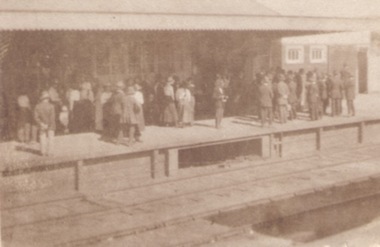
Photograph, c1920s
... The crowd of people are waiting on Platform 1 at Sunbury... of people are waiting on Platform 1 at Sunbury Railway Station ...The crowd of people are waiting on Platform 1 at Sunbury Railway Station. A sepia photograph of a crowd standing on a station platform waiting for a train to arrive.sunbury railway station -
 Sunbury Family History and Heritage Society Inc.
Photograph, c
... The steam train has arrived at Number 2 platform at Sunbury... train has arrived at Number 2 platform at Sunbury Railway ...The steam train has arrived at Number 2 platform at Sunbury Railway Station. Before diesel engines were used on the regional lines, steam trains were widely used. The pedestrian bridge spanning the railway line was replaced with a larger one to allow for disabled people's in 2001.A coloured photograph of a steam train arriving at a station with six people on the pedestrian bridge looking at the train and five other bystanders on the two platforms.steam locomotives -
 Sunbury Family History and Heritage Society Inc.
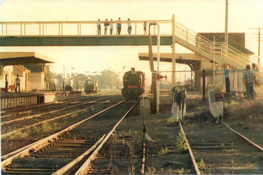
Photograph, c
The photograph shows a view of Sunbury Railway station as it was in the 1970s and earlier. he image is looking south to the railway crossing at Station Street and the storage sheds which were along Platform 1, where the trains for Melbourne left.A coloured photograph of a railway station and pedestrian bridge.sunbury -
 Sunbury Family History and Heritage Society Inc.
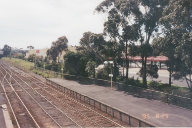
Photograph, 25th July 1995
The photograph of Sunbury Station was taken from the pedestrian bridge and is looking north to take in the Sunbury Square shopping centre buildings and the bus terminal which are on the Platform 1 or east side of the station.During the 1990s much development took place in Sunbury and the station precinct became a commercial hub.A coloured photograph of a railway station and a Coles Supermarket in the middle distance as well as a bus terminal. -
 Sunbury Family History and Heritage Society Inc.
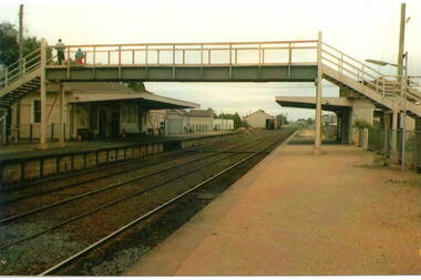
Photograph, 15th
... A coloured photograph of a platform at a railway station... of a platform at a railway station which includes a pedestrian bridge ...The Number 2 platform at Sunbury Station is featured in this image along with the former wooden pedestrian bridge and partial view of the two water towers, which in the past were used to supply water for the steam engines. A coloured photograph of a platform at a railway station which includes a pedestrian bridge and metal water tower. sunbury railway station -
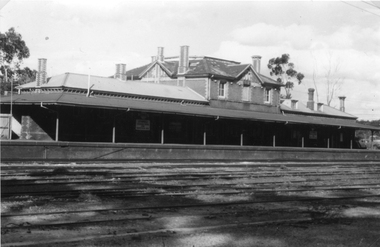 Stawell Historical Society Inc
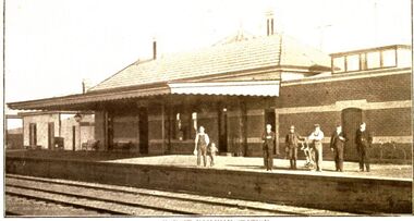
Photograph, Railway Station Stawell
Railway Station Stawell. B/W photo showing large two storey brick station with long verandah over platform in heavy shade. Rail lines in foreground. This Photograph is a copy of a Negative owned by the Society - paid from a grant 1991. This Photograph is of Stawell Railway Station.B/W. Photograph of Stawell Railway Station taken from acroos the railway tracks. Also showing two vechiles of the far right. the centre of the building is two story stawell railways, transport, mark dadswell -
 Surrey Hills Historical Society Collection
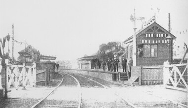
Photograph, Surrey Hills railway station on Empire Day in 1909
Man in the signal box is believed to be Mr J Rasmussan and the assistant stationmaster, Mr Tom Keating. Published in book 'Surrey Hills in Celebration of its Centenary: 1883-1983', compiled by the History Nook and edited by William Chandler.Black and white photo of Surrey Hills railway station on Empire Day in 1909. Signal box and station are decorated with bunting and lanterns. Gates are closed and there is a man in the signal box. There are approximately 9 men on the platforms including the stationmaster, assistant stationmaster, Mr Tom Keating and other railway officials.transport, empire day, railways, surrey hills station, mr tom keating, mr j rasmussan -
 Surrey Hills Historical Society Collection
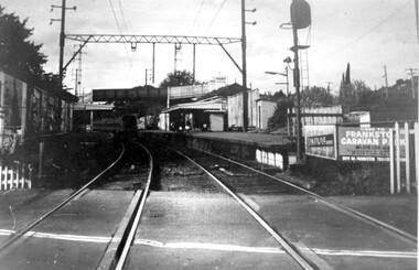
Photograph, Surrey Hills railway station, 1973, 1973
... before the station was demolished. railways land transport surrey ...This would have been taken shortly before the station was demolished.Black and white photo of Surrey Hills railway station taken from the tracks near the gates in 1973. It shows the wooden pedestrian overpass and the original station buildings with extended shelters over the platforms.There is a newspaper kiosk on the southern platform. The train is coming into the platform and there is a small group of passengers waiting. Advertising hoarding for Spaceline Homes and the Frankston Caravan Park are mounted at the end of the southern platform. railways, land transport, surrey hills railway station -
 Surrey Hills Historical Society Collection
Photograph, Early electric train at Mont Albert Station, c1926, 1926
Date is approximate. Electric trains replaced steam locomotives in 1922. Mr William Holmes of 'Lugano', Mont Albert Road was in charge of the design and introduction of the electrification of the Melbourne rail system.Black and white photo of an early electric train approaching the platform at Mont Albert station. A couple of spindly eucalyptus trees can be seen beyond the picket fence marking the boundary of the platform.Black and white photo mounted on card; measures 16.3 cm x 23.4 cm.mont albert station, railways, trains, norman carter -
 Surrey Hills Historical Society Collection
Photograph, D716 steam train at Mont Albert Station, 1919, 1919
The photo was taken at 8.15am on Friday 12 September 1919. The D class was a passenger and mixed traffic steam locomotive which operated on the Victorian Railways from 1902 to 1974. Originally it was introduced on mainline express passenger services, but they were quickly superseded by the much larger A2 class and were relegated to secondary and branch line passenger and goods service, where they continued in service for the next fifty years. The D716 was probably built at the Newport Workshops, post 1910 and before 1914. The expansion of Melbourne's population into new suburbs early in the 20th century, and the delay of the suburban electrification project, meant there was the need for faster and more powerful steam locomotives for the suburban rail network. In 1908, the basic design was adapted to create a more powerful locomotive. They were put to work on longer and hillier suburban routes including the Lilydale line. A total of 58 were built between 1908 and 1913. See wikipedia for a more detailed history of the D class locomotives. Electric trains replaced steam in 1922. Mr William Holmes of 'Lugano', Mont Albert Road was in charge of the design and introduction of the electrification of the Melbourne rail system.Black and white photo of a steam train approaching the platform at Mont Albert station. Rear in blue biro in Jocelyn Hall's handwriting: "Hamilton St Mont Albert / probably 1919".mont albert station, railways, trains, d class locomotives, norman carter, steam trains -
 Surrey Hills Historical Society Collection
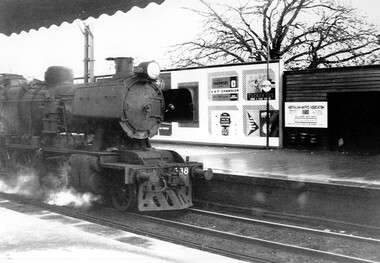
Photograph, Loco J538 at Surrey Hills in 1961, 1961
We have an original copy donated by Ian Barkla and a larger one copied by Ken Hall. The Barkla original has a sticker with his reference details on the back. Photographed in 1961 proceeding east towards Box Hill.A black and white photo of a steam engine at Surrey Hills station. Signboards on the platform refer to K.S.P. Chandler-Hardware; Tucker box dog and cat food, 3UZ the station with the nicest listeners; Australian Native Association and Rou ... watches.1961, trains, railways, steam trains, k.s.p. chandler, hardware, tucker box, 3uz, australian natives association, surrey hills railway station -
 Port Fairy Historical Society Museum and Archives
Photograph
Koroit Railway Station closed in 1975 when the rail to Port Fairy was also closed. Unlike the Port Fairy Station the Koroit Station has been restored and is used by local groups and is of course part of the Rail trail from Port Fairy to WarrnamboolBlack and white photograph of Koroit railway station with 6males and a child on platformtransport, rail, road, koroit, railway station -
 Surrey Hills Historical Society Collection
Digital photo, George L Coop, Mont Albert Railway Station c 1956, c1956
The donor George Lister Coop was about 19 years of age when he took this photo. It is one of a small series of photos donated by him that relate to Mont Albert and Surrey Hills stations. He has always had an interest in railways and there are other examples of his documentation of railway history in other collections contributing to this database. This documents the original building on the northern platform of the Mont Albert station. The railway line was extended out to Lilydale with work commencing in 1882. It is not known exactly when the Mont Albert station was built, but it opened in 1890. It is presumed that this building was demolished when the third line was constructed in 1971. At this time the nearby Surrey Hills original station buildings were demolished.A black & white photo of Mont Albert station taken from the north platform adjacent to High Street, looking towards Box Hill. It clearly shows the bend in the line beyond the platforms. it also shows both the original buildings; the one on the north side having been demolished. There is a lady on the south platform adjacent to Hamilton Street. The roof line only of one of the Hamilton Road shops can be seen.george lister coop, mont albert station, 1956, hamilton street shops