Showing 2478 items
matching river street
-
 Orbost & District Historical Society
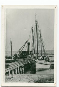
black and white photograph, before 1912
This photo shows the Storm Bird at the end of the jetty and the Wangrabelle in the foreground. Both ships were well known traders. the Wangrabelle became beached and wrecked in 1916 and the Storm Bird became obsolete when the railway from Bairnsdale to Orbost arrived in 1916. (ref. Story of Gippsland Shipping - J.C. Bull) At the start of the river trade goods were shipped from Marlo to Melbourne but when the railway reached Bairnsdale this became unprofitable and the ships plied only between Marlo and Cunninghame. Eventually river transport became economically unviable. The Wongrabelle is still buried in the sands of the entrance of the Snowy River (albeit where the entrance used to be). It took from April 11th 1912 to August 12th 1912 for the loss of the Wongrabelle to be complete, the final entry in the Orbost Shipping Co. records reads:- "The Wongrabelle is completely covered in sand." (ref River, Road, Railway Newsletter O.D.H.S.) This is a pictorial record of a time when the water highways were the only feasible transport mode in sending goods from Orbost and Marlo to Melbourne.A black / white photograph of a ship, sails down, anchored at the Marlo jetty.on back - "M. Gilbert, Wangrabelle at Marlo"storm-bird wangrabelle shipping transport- marlo -
 Orbost & District Historical Society
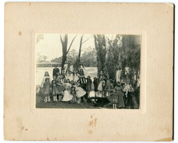
black and white photograph, 1920s
The bridge shown in the background was built in the 1920s as a road and rail bridge, and was partly washed away by flood waters in 1934. There is no known history of this item.This photograph is a contemporary record of rural life in Orbost in the early 20th century.A black / white photograph of a group of young girls dressed up and posing on the banks of a river. On the left hand side of the photograph is an older man and on the right is an older lady. In the background is a bridge - the first Snowy River bridge. The photograph is on a cream coloured buff card. orbost snowy-river -
 Orbost & District Historical Society
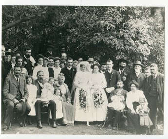
black and white photograph, April 15 1909
This photograph shows the wedding of Maggie (Fran Margaret) Middleditch form Murrangowar to Frank Day who worked in the local saddler's shop. An article in the The Snowy River Mail and Tambo and Croajingolong Gazette : ORBOST PETTY SESSIONS. 8 April 1909 Constable O'Shannassy proceeded against Frank Day on a charge of being unlawfully in possession ol four kangaroo skins. Frank Merson Day was born in 1887 and died 1950. he was the son of George Seears Day and Annie Grose He and Maggie had four children : Eileen Margaret Annie Day; Francis Day; Anne Day and Frank Day. This is a pictorial record of a social event in Orbost in the early 20th century. Those recorded have connections to Orbost.A large black / white photograph of a wedding party. The bride and groom are surrounded by family. Some are seated and most standing in front of some tall trees. There is a photocopy with a list of those in the photograph.on back - "Mary Gilbert"day-frank middleditch-maggie -
 Orbost & District Historical Society
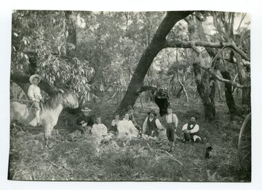
black and white photograph, 1901
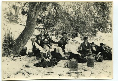
This photograph was taken at the "old station" at Corringle near Orbost. It was a popular picnic spot. Late in 1857 Mr Thomas T. Stirling took over Corringle Run ("Corringle" means "shallow water"). Mr Stirling and his family came from the wester district - Winchelsea. He settled at the Old Station. A few people were employed at the Orbost Stationb and there was settlement on the Orbost flats, Mr T. T. Stirling held the land from Lake Tyrers to Bemm River as a cattle run. About 1888 he became Secretary of the new Tambo Shire.This is a contemporary pictorial record of rural family life in Orbost in the early 20th century.A black / white photograph of a group of people sitting in a clearing under some trees having a picnic. On the left - hand side is a young boy on a horse.on back - "Old Station"old-station-orbost family-life -
 Orbost & District Historical Society
black and white photograph, 1901
The Old Station at Corringle was a popular picnic spot in 1901. Late in 1857 Mr Thomas T. Stirling took over Corringle Run ("Corringle" means "shallow water"). Mr Stirling and his family came from the wester district - Winchelsea. He settled at the Old Station. A few people were employed at the Orbost Stationb and there was settlement on the Orbost flats, Mr T. T. Stirling held the land from Lake Tyrers to Bemm River as a cattle run. About 1888 he became Secretary of the new Tambo Shire.This is a contemporary pictorial record of rural family life in Orbost in the early 20th century.A black / white photograph of a group of early settlers (it appears to be a family group) having a picnic underneath trees. There is a young boy on a horse on the left hand side.on back - "Picnic at the Old Station"family-rural-life-orbost old-station-corringle -
 Orbost & District Historical Society
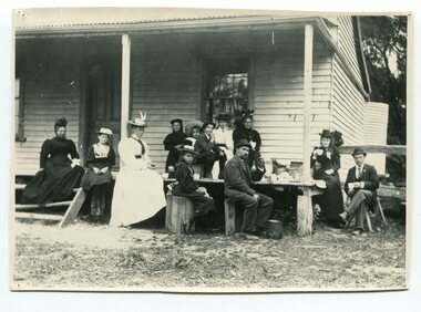
black and white photograph, Green, O. S, April 1897
This photograph shows the Richardson family having a picnic on the verandah of Captain McNeil' house at Marlo - April 1897. Snowy River Shipping Company formed in 1880. They were soon shipping produce (mainly vegetables) from the area to Melbourne. The Snowy River Shipping Company was formed by Mr Henry James during the 1880s, with Captain McNeil as master. Captain Hegarty was the shipping agent at Marlo. Towing a line of small barges these paddle steamers plied their trade between the port of Marlo, and the farms along the river banks, churning their way almost twenty miles upstream to a landing beside what is now Frank Richardson’s property. On these trips, the barges carried mail and supplies to the townspeople and farmers, loading their produce, mostly maize, on the return trip to the coast. The coming of the railway in 1915 spelt the end for the little river boats. ( ref. F. W. RODWELL in the “Snowy Review”) Frank Richardson 1877-1950 was a sawmiller at Tabbara and helped build and run paddle steamer "Curlip"as engineer. Captain McNeil was an always cheerful Marlo identity and local children had many times sailing with him on the river. Captain McNeil with tug went out through the entrance and brought in the schooners.This item is associated with the Richardson family, early settlers of the Orbost district.A black / white photograph of a group of people having afternoon tea on the end of a verandah of a wooden house. All are seated.on back - " The Richardson family picnic at Marlo"richardson-family-orbost-marlo mcneil-captain -
 Orbost & District Historical Society
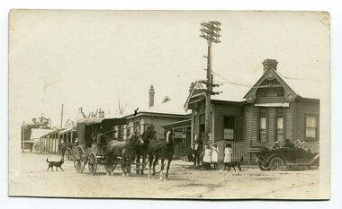
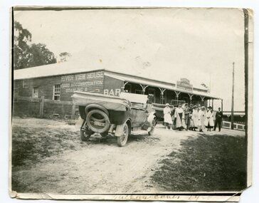
black and white photograph, C 1915 -1920
This photograph shows the main street of Orbost and in particular, the Orbost Post Office. The wagon in the photograph is on its way to Cann River.This photograph is a pictorial record of the township of Orbost in the early 20th century,A black / white photograph with a cart drawn by three horses. Standing in the street are three young girls and a man. There is a motor car, roof down, on the right hand side. There are two dogs in the photograph whic has been taken outside the post office in the main street of Orbost. There is a hand-drawn cross on the roof of the building adjacent the post office. Buildings are wooden.on back - "X indicates bank, caravan and ? horses is coach bound for Cann River, meeting place"transport-orbost post-office-orbost -
 Orbost & District Historical Society
black and white photograph, January 1, 1897
This photograph shows Mr John Bird ( 3rd from left) ; Mr John Gilbert and Mr Lance Herbert among others having a picnic at the popular beach paddock at Old Station, Corringle, on January 1, 1897. Late in 1857 Mr Thomas T. Stirling took over Corringle Run ("Corringle" means "shallow water"). Mr Stirling and his family came from the wester district - Winchelsea. He settled at the Old Station. A few people were employed at the Orbost Stationb and there was settlement on the Orbost flats, Mr T. T. Stirling held the land from Lake Tyrers to Bemm River as a cattle run. About 1888 he became Secretary of the new Tambo Shire.This photograph is a portrait of rural life in the late 19th century. It is an insight into the dress, manners and activities of the first settlers of Orbost.Two copies of a black / white photograph of a group of men and women picnicking on the sand under tall trees.on back - "Beach Paddock - Old Station -1897" with a list of namesold-station-orbost rural-family-life -
 Orbost & District Historical Society
black and white photograph, 1930 - 1940
This photograph shows three generations of the Russell family in Orbost. On the left is John Russell with his son Bill Russell and his wife Ede and their son Ian. John Russell Senior was a blacksmith, wheelwright, farmer and chairman of the Orbost Butter Factory, makers of Sunny South Butter (today part of Murray Goulburn Co Ltd). Bill was born at Orbost in 1893, the youngest son of John and Elizabeth Maud (nee Clarke). Upon his father’s retirement he took over the homestead part of the holding, 1,000 acres of river flats and hill land. He was involved in dairying and was also a successful beef cattle breeder and maize grower. He was elected to the Orbost Shire Council in 1929 and shortly afterwards was President for 18 months (from May 1930 to August 1931). He served a further term as President in 1934-35. He represented the South riding. He was chairman of the Bean Board and a well-known horse and show judge and a member of the Royal Agricultural Society. He was an elocutionist of some note and a member of the committee of management of the Orbost Hospital. He was also a prominent member and Past Master of the Masonic Lodge and a Justice of the Peace. He served as president of the Orbost Golf Club and assisted with the preparation and layout of the present Orbost Golf course. This item is associated with the Russell family, early settlers in the Orbost district.A black / white photograph of a family. A lady is in the middle with a man on each side and a young boy in front. They are standing outside a house in the garden.on back - "3 generations, Johnny Russell, Ede & Bill Russell & Ian Russell"russell-family-orbost -
 Orbost & District Historical Society
coloured photograph
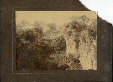
There is no information with this item. "The Pyramids", was named due to huge rocks that jut out from the hill, being shaped similarly to the Egyptian Pyramids. " Where the Murrindal River winds between high limestone bluffs before disappearing into a mountainside and becoming an underground river, four miles north-east of Buchan, is the region known as The Pyramids. It is an area of limestone caverns and sink holes overshadowed by three rock stacks. Some of the caves are the last resting places of long dead Murrindal animals." ( from MBW Walk magazine 1970 - Melbourne Bushwalkers"A hand-painted colour photograph of a view of mountain ranges with men on horses in the background.on front - "Pyramid Gorge Buchan"pyramid-gorge-buchan murrindal limestone-caves -
 Orbost & District Historical Society
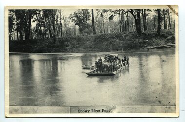
black and white photograph, late 19th century
A punt crossed the Snowy River at Orbost from 1884. A bridge was constructed in 1893, but was soon damaged by a huge flood. Flooding was a regular occurrence, the worst inundations being in 1870, 1893, 1925, 1934, 1952 and 1971. Over the years major flood protection works have been implemented. The Princes Highway, which passes Orbost, now crosses the flood plain on raised concrete supports. (info, from Victorian Places Orbost)This item is associated with the Snowy River and its history. It is a pictorial record of transport in the late 19th century.A black / white photograph (copy) of a punt loaded with people and a horse-drawn carriage making its way across a river.on front at bottom - "Snowy River Punt"snowy-river-orbost transport shipping -
 Orbost & District Historical Society
black and white photograph, 1900
This photograph was taken in 1900 at Buchan. The River View Hotel was established in Buchan in 1884 and was possibly first called the Cricket Club Hotel. The isgn at the front of the building suggests that a ? Cameron ran the establishment.This an early pictorial record of Buchan in the 1900s.A small black / white photograph of a group of people standing outside a hotel A motor vehicle is in the foreground and another behind the people. On the right side of the wooden building is a sign indicating that this is River View House an accommodation business. At the front is a sign with the name ?. Cameron on it.on front - "Buchan Caves - 1900" on back - "E.A. Paige"buchan-river-view-hotel -
 Orbost & District Historical Society
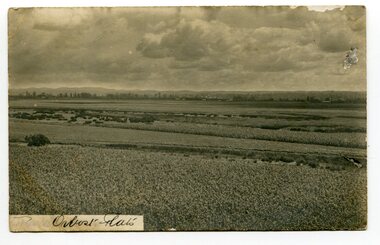
black and white photograph, Sherwood, first half 20th century
This postcard is addressed to Tom Lloyd from Uncle Frank c/o F. Lloyd Esq, Bairnsdale.This item is a pictorial record associated with the agricultural history of Orbost. .The extensive Snowy river flood plain was swampy, but by the 1880s the river flats were being drained. The Orbost flats are very fertile and crops were planted on the rich deep soil, with maize rapidly becoming widespread.A black / white photograph of the Orbost farming flats. The sky is very cloudy. There are paddocks of crops in the foreground.on front - "Orbost Flats" on back - "How are you enjoying your holiday.......Uncle Frank"orbost-flats-farming lloyd-frank -
 Orbost & District Historical Society
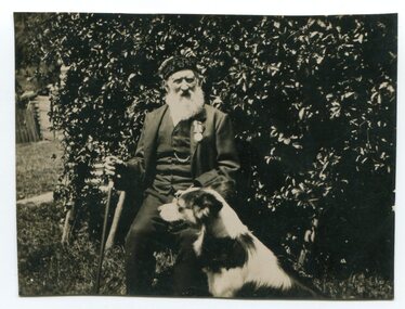
black and white photograph, early 20th century
This is a photograph of Samuel Smith, aged 92, with his dog outside his home, Gloucester House, near Cann River. He was the keeper at CapeEverard (Point Hicks) for five years.He retired from the lighthouse position in 1904. His life story was written in The Snowy River Mail, Orbost, Wednesday Evening – 27 January 1937 as "LIFE STORY OF SAMUEL SMITH". He was born in Gloucestershire in 1844 and died in 1937 at the the Orbost Hospital. There was an obituary in The Argus (Melbourne) on Saturday 18 February, 1939. Samuel Smith, of Noorinbee, East Gippsland, was the last survivor of the original crew of the frigate Victoria, the first vessel of the old Victorian Navy. When the Victoria arrived in Melbourne in 1861 after having landed soldiers in New Zealand for the Maori War, the crew was given a civil reception, and each member was presented with a sovereign in honor of the birth of the Victorian Navy. A black / white photograph of a bearded elderly man sitting and holding a cane. A dog is sitting at his knee. The photograph has ben taken outside in a garden.on back - "Samuel Smith, Head Lighthouse Keeper at C. Everard, retired 1904"cape-everard point-hicks smith-samuel -
 Orbost & District Historical Society
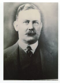
black and white photograph, C1928
This is a photograph of Orbost Shire Councillor Henry James J.P. who represented Central Riding 1902-1905 and 1916-1927. Henry James (1860-1932) was a well-known identity in the Orbost district. He was a stock agent and auctioneer who helped to establish the seed bean industry in Orbost. He was the second secretary of the Snowy River Shipping Co. as well as a shire councillor and prominent member of MUIOOF.This item is associated with the Orbost Shire Council. The shire covered an area of 9,347 square kilometres and existed from 1892 until 1994 when it became part of the East Gippsland Shire Council. Henry James was a well-known Orbost identity.A black / white head and shoulders portrait photograph of a moustached man in a suit.on back - "Cr H. James JP"james-henry orbost-shire-council -
 Orbost & District Historical Society
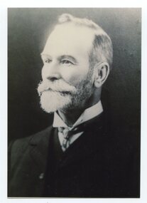
black and white photograph, late 19th / early 20th century
This is a photograph of Councillor Charles Henry Grove who represented South Riding on the Orbost Shire Council. from 1893 - 1901. He was president in 1893-1894, 1895-1896 and 1900-1901. He also served on the Tambo Shire prior to the formation of the Croajingolong / Orbost Shire. Charles Henry [Carl] Grove died on 17/4/1938 at Box Hill at the age of 88 and was buried in Orbost. Prior to coming to the Snowy River district, Carl worked as overseer on Buchan Station. In 1880, he selected land at Newmerella after first coming here in 1874 with early selector James A Robertson. He married Annie Robertson in 1876. Carl was a farmer, hop and seed grower and nurseryman. He was an elected Councillor of the newly formed Tambo Shire in 1882, and then in 1892 to the Orbost Shire where he served for many years filling various public roles. In 1911, he shifted to Queensland, but later returned to Victoria and died at Box Hill. (info. Newsletter 113)This item is associated with the Orbost Shire Council. The shire covered an area of 9,347 square kilometres and existed from 1892 until 1994 when it became part of the East Gippsland Shire Council. It is associated with Carl Grove, a prominent early Orbost citizen.A black / white head and shoulders portrait photograph of a bearded man in a suit. There is also a framed copy.grove-charles-henry grove-carl orbost-shire-council -
 Orbost & District Historical Society
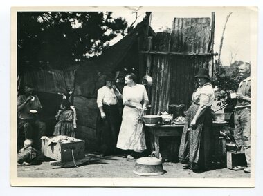
black and white photograph, C1916
This is a photograph of a railway camp, set up to house workers and their families when building the Bairnsdale to Orbost Railway in 1916. The Bairnsdale-Orbost railway was opened in 1916 to serve the agricultural and timber industry. Because of the decline in traffic and heavy operating costs, the line was finally closed in August, 1987. Orbost Railway Station was opened on Monday 10 April 1916 as the terminus of the Orbost railway line, and closed in 1987. The station was located on the west side of the Snowy River despite the town of Orbost being on the east side of the river, in order to save on the costs of a bridge over the river, which at the time had highly variable levels.This item is associated with the history of the Orbost-Bairnsdale railway line and therefore reflects the role that the rail line played in the social and economic history of Orbost.A black / white photograph of a campsite kitchen. The kitchen is outside against a roughly constructed hut. There are three women preparing food. Two men are drinking from tin mugs. a small child is crawling on the ground and another is seated.on back - "Railway Camp"orbost-railway newmerella-railway-camp transport -
 Orbost & District Historical Society
black and white photograph, 1918
Tonghi Creek is 66km north - west of Orbost. Prior to the sealing of the Princes Highway west of Orbost, the road surface was anything but good, even by C1917 when cars started to use the road. From Orbost the old road via Marlo to Sydenham was abandoned for the new location which traversed more rugged country via Cabbage Tree, Bell Bird and Club Terrace to Cann River, and the reason for this diversion was on account of settlements being established at Murrungowar and Club Terrace, at which latter place there was a temporary rush to obtain gold. This road was constructed by the Public Works department and a maximum grade of 1 in 19 was adopted, and as speed was not to be catered for the grade followed in and out round the spurs and gullies, resulting in a maze of turns and twists which required a good deal of skill on the part of the horse driver to negotiate." - Bairnsdale Advertiser, Friday, May 2, 1947. (More information from Newsletter February 2010)This item is a pictorial record of roads in the early 20th century in East Gippsland.A large black / white photograph of a bridge over a small creek, surrounded by bush. The photograph is mounted on a thick cream coloured card.on back - "Bridge at Tonghi Creek 1918"tonghi-creek-bridge country-roads-east-gippsland -
 Orbost & District Historical Society
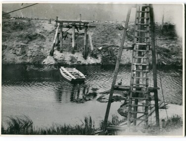
black and white photographs, 1915
This photograph is of the construction of the first road bridge over the Genoa River - 1915. Before today's timber truss and concrete bridge was constructed between 1926-1928 by contractor J.T. Noble Anderson, two earlier bridges crossed the Genoa River at this location. They provided crucial links in the Princes Highway route from Melbourne to Sydney. The letter on the back of the postcard was written by Gordon ? to Alex ? on 2nd October 1917. "this represents the opening of Genoa Bridge. Mrs Alexander cutting the ribbon and Mr Martin holding it at the other side. Did most of the speaking. The gent holding the roll of paper is who came to open the bridge. I can't think of his name. Hubert is standing up at the right / Gordon " This is a pictorial record associated with the history of Genoa in East Gippsland.1100 -A large black / white photograph on a cream coloured buff card. It is of an unfinished bridge with men working there. A small rowboat can be seen on the far side of the river. 1100.1 - A photograph / postcard of the opening of "Genoa Bridge 1917". There is a ribbon stretched across the timber decking road in front of a group of people. 1100.2 - A black / white photograph of a road bridge across a river.on back - "Princes Highway - the 1st bridge over the Genoa River - 1915" on back of 1100.1 is a hand-written letter.genoa-bridge princes-highway-east-gippsland -
 Orbost & District Historical Society
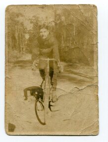
black and white photograph, 1920 - 1930
By 1905 there was an Orbost Bicycle Club. E. Donchi was a member and was a successful competitor around 1927. It is likely that the Orbost Cycling Club disbanded during WWI, and evidence from the Snowy River Mail is that it reformed again in 1945. There is no doubt that bikes were a dominant form of personal transport until the 1960s when cars ownership became more common, although children still rode to school. As far as theOrbost Cycling Club was concerned, the golden years were from 1945 to 1950. (information Newsletter August 2018 - Geoff & Lee Stevenson)This item is associated with a popular recreational activity in early Orbost. The period between the First World War and the 1950s was the heyday of cycling. After 1900 the efficient mass production of standardized safe bicycles, as well as the wider availability of second-hand bicycles, caused rapidly dropping prices and it was therefore easier for people to purchase a bicycle not only for utilitarian use but for racing. A small black / white photograph of a young man on a racing bike. It is on an unsealed road in a forest. on back - "E. Donchi, Cyclist, Orbost"donchi cycling-orbost recreation -
 Orbost & District Historical Society
black and white photograph, first half 20th century
This is the Dalgety bridge across the Snowy River. It is a steel construction.The first bridge over the river was constructed in 1888. There was a punt across the river before the bridge was built . Dalgety is a small service centre, located on the Snowy River approximately 235 km from Orbost. It was an early consideration for the site of Australia,s capital city. The Dalgety Bridge over the Snowy River has been an important item of infrastructure in the history of New South Wales for over 110 years. It was designed by noted bridge engineer J. A. McDonald,and was a technically sophisticated bridge structure for its time. This is a pictorial record of a significant structure on the Snowy River.A small black / white photograph of a large bridge over a river.bridge-dalgety-snowy-river -
 Orbost & District Historical Society
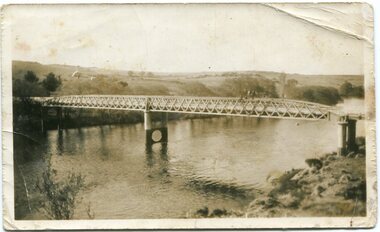
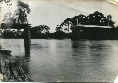
black and white photographs, Howard D. Bulmer, first half 20th century
This bridge was built in the 1920s as a road and rail bridge, and was partly washed away by flood waters in 1934. After the end of the first World War the Victorian Railways considered an extension of the railhead across the river at Orbost, and in 1922 a new timber and steel girder structure, a joint Country Roads Board — Victorian Railways venture, was built and completed at a cost of £41,000 (the steel girders came from the Flinders Street viaduct reconstruction). Subsequently it was decided not to take the railway across the river, and the bridge has only been used by road traffic. This is a pictorial record of an early bridge across the Snowy River at Orbost.A large black / white photograph of the Orbost Snowy River bridge. There is a large copy as well as a postcard copy in sepia.on front - Snowy River Bridge Orbost H.D. Bulmer - photo - Lake Tyers.snowy-river-bridge-orbost -
 Orbost & District Historical Society
black and white photograph, January 1934
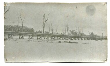
Orbost has been subject to major floods throughout its history, such as those which left the town isolated in 1934, 1952, 1971 and 1978. It is recorded that the Snowy River broke its banks and flooded the flats 104 times between 1884 and 1978. Extensive flooding in Eastern Victoria during June 1978, caused widespread damage to roads, road closures and hazards to traffic, particularly over the Queen's Birthday holiday weekend.This is a pictorial record of a significant event in Orbost's history.A very faded black / white photograph of flood water under the railway viaduct at watt's Gulch.orbost-flood-1934 railway-viaduct-orbost -
 Orbost & District Historical Society
black and white photograph, July 1922
A new bridge over the Snowy River at Orbost was opened for traffic on June 20th 1922. It was designed for future joint use by road and railway traffic, but it was only used for road traffic. During the last few years the condition of an old suspension bridge [the 1893 bridge] which was the only vehicular crossing between the town of Orbost and the railway station, caused much concern. The structure was of timber, except for the wire suspension cables of its central span of about 100 feet. A design was prepared in 1914 for a permanent bridge with five spans of 85 feet composed of plate girders on concrete piers. With great increase in the price of steel work during the war, the cost of this design became prohibitive, and the need for a new structure becoming urgent, alternative proposals were investigated. As a result the present design was adopted as providing a sem-permanent bridge at moderate cost. The new bridge spans the river about 160 feet upstream from the old bridge on a slight skew, the piers being at an angle of 80 degrees with the centre line of the bridge. It has a camber of about 2 feet 5 inches in its total length of 527 feet. ( information from Newsletter March 2014 - Lois Crisp) The photograph shows Mrs James Cameron cutting the ribbon at the opening of the Orbost Pile Bridge in 1922. This second bridge, was built by the Victorian Railways and the Country Roads Board. Constructed at a cost of 35,000 pounds and used second-hand girders from the Flinders Street- Spencer Street viaduct. On July 4 1922 it was officially opened by Mrs James Cameron. Unfortunately, her husband, who had long championed the building of the bridge so that it would be ready for the railway to continue to the border, was too ill to attend the ceremony. In fact, James Cameron died on July 13 after a long and severe illness (ref. S.R.M. 20.7.1922). There is a section of this ribbon in the collection - Registration No. 366. This is a pictorial record of a significant event in Orbost's history.A black / white photograph of a pile bridge with a suspension bridge behind it. There are many people standing on the bridge.on back - "Opening of Pile Bridge - 1922"snowy-river-bridge ceremonies cameron-mrs -
 Orbost & District Historical Society
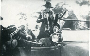
black and white photograph, July 1922
The photograph shows Mrs James Cameron cutting the ribbon at the opening of the Orbost Pile Bridge in 1922. The first bridge was officially opened in August, 1893 (ref. S.R.M. 12.8.1893) by Mrs W. Watt, the mother of Councillor Watt, who presided over the opening of the 1922 bridge. This bridge was extensively damaged when a herd of cattle allegedly stampeded over it causing the cable to snap. Even after repairs it became obvious that a new bridge was needed. This second bridge, was built by the Victorian Railways and the Country Roads Board. Constructed at a cost of 35,000 pounds and used second-hand girders from the Flinders Street- Spencer Street viaduct. On July 4 1922 it was officially opened by Mrs James Cameron. Unfortunately, her husband, who had long championed the building of the bridge so that it would be ready for the railway to continue to the border, was too ill to attend the ceremony. In fact, James Cameron died on July 13 after a long and severe illness (ref. S.R.M. 20.7.1922). There is a section of this ribbon in the collection - Registration No. 366.This item is a pictorial record of a significant event in Orbost's history.A black / white photograph of a lady standing up in a motor vehicle cutting a ceremonial ribbonsnowy-river-bridge-orbost cameron-mrs ceremonies -
 Orbost & District Historical Society
black / white photograph, January 1934
Damage estimated at £500,000 was caused by the 1934 floods in the Orbost district. This 1934 flood was devastating, destroying a section of the 1922 Orbost bridge, wrecking fences, bridges and roads, dumping silt and debris on the rich river flats and drowning cattle. This photograph shows Lochiel Lagoon ( the billabong) in the foreground. Ten minutes after this photograph was taken, the centre span of the Orbost Bridge was washed away.This item is a pictorial record of the 1934 floods, a significant part of Orbost's history.A black / white photograph of swirling floodwaters with township in the background.orbost-floods-1934 natural-disasters-floods -
 Orbost & District Historical Society
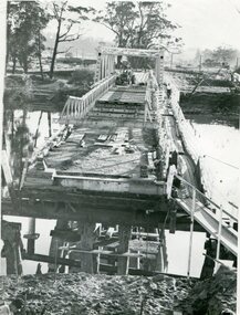
black and white photograph, January 1934
Damage estimated at £500,000 was caused by the 1934 floods in the Orbost district. This 1934 flood was devastating, destroying a section of the 1922 Orbost bridge, wrecking fences, bridges and roads, dumping silt and debris on the rich river flats and drowning cattle. The centre span of the Orbost Bridge was washed away. This item is a pictorial record of the 1934 floods, a significant part of Orbost's history.A black / white photograph showing the flood damage to the Snowy River Bridge. There is a gap in the bridge where the centre span has been washed away. In the background is a punt.orbost-floods-1934 natural-disasters-floods snowy-river-bridge -
 Orbost & District Historical Society
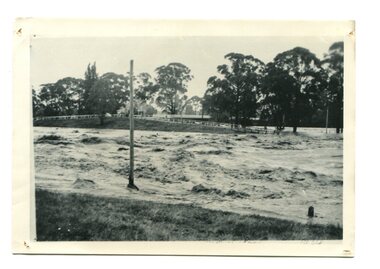
black and white photograph, February, 1971
This photograph shows the floodwaters during the 1971 flood at Orbost. The two mahogany trees in the photograph stopped the Snowy River from changing its course. The 1971 flood was the the worst flood on record. At Jarrahmond it was at least 11 metres and up to one and a half kilometres wide on the flats causing enormous damage to the flood plain. Records say that "The brown floodwater stain in Bass Strait could be seen from passing airliners." Considerable damage was done to railway infrastructure, roads and farms. More information from the APRIL, 2008 newsletter by John Phillips. (see orbosthistory.com.au)This is a pictorial record of a significant event in the history of floods in Orbost.A black / white photograph of raging floodwaters at the bottom of the Orbost township.orbost-flood-1971 -
 Orbost & District Historical Society
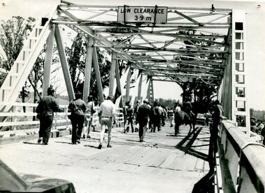
black and white photograph, 1976
This bridge over the Snowy River was opened on July 4 1922. It was constructed in 1922 alongside the previous suspension bridge. Its building was a combined effort of the Victorian Railways and the Country Roads Board at a cost of 35,000 pounds. It was replaced in 1976 by the present bridge after several major floods. This photograph shows people walking over the bridge for the last time.This is a pictorial record of the former Snowy River Bridge at Orbost.A black / white photograph showing a group of people walking across a bridge. There are several cars, a man on a horse and people standing on the side of the roadway.on back - "1976 - old bridge"snowy-river-bridge-1976 -
 Orbost & District Historical Society
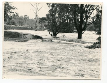
black and white photograph, 1971
This photograph shows the second major bridge across the Snowy River at Orbost. The current Snowy River bridge is the fourth to provide a crossing to the township of Orbost. The first, in 1891, lasted just two years before it succumbed to flood waters. The bridge in this photograph was built in the 1920s as a road and rail bridge, and was again partly washed away by flood waters in 1934. After the end of the first World War the Victorian Railways considered an extension of the railhead across the river at Orbost, and in 1922 a new timber and steel girder structure, a joint Country Roads Board — Victorian Railways venture, was built and completed at a cost of £41,000 (the steel girders came from the Flinders Street viaduct reconstruction). Subsequently it was decided not to take the railway across the river, and the bridge was only used by road traffic. It was severely battered by floods during its life. and after the devastating 1971 floods was eventually replaced by the current bridge in 1975. (info from Newletter 54N by John Phillips)This is a pictorial record of the flood damage in 1971 when part of the Snowy River Bridge was washed away.A black / white photograph of a bridge which has been damaged by floodwaters. It shows one end has been washed away.orbost-snowy-river-bridge-1971 floods-orbost-1971