Showing 223 items
matching road widening
-
 Whitehorse Historical Society Inc.
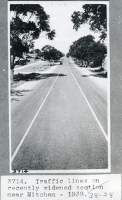
Photograph, Whitehorse Road Mitcham,1938
... widened section of Whitehorse Road near Mitcham in 1938. Other...Whitehorse Historical Society Inc. 2-10 Deep Creek Road ...Black and white photograph of traffic lines on recently widened section of Whitehorse Road near Mitcham in 1938. Other No. 3714.whitehorse road, mitcham. -
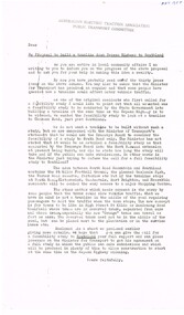
 Whitehorse Historical Society Inc.
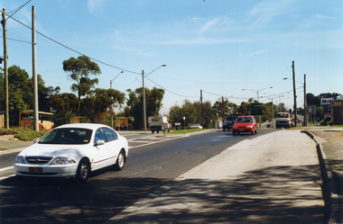
Photograph, Prior to Construction of Mitcham Road, 1/02/2000 12:00:00 AM
... . This photograph was taken just prior to widening of Mitcham Road.... prior to widening of Mitcham Road. Prior to Construction ...Coloured photograph of Mitcham Road, looking towards Springvale Road Junction. Donvale Bus Terminus on left, Mobil Service Station on right, as is a small shopping centre which consisted in earlier days as only a family operated general store. This photograph was taken just prior to widening of Mitcham Road.mitcham road, donvale, springvale road -
 Whitehorse Historical Society Inc.
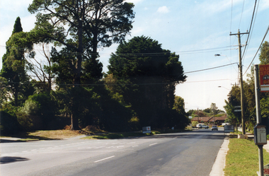
Photograph, Prior to Construction of Mitcham Road, 1/02/2000 12:00:00 AM
... Road with Wrendale Drive on left. Taken prior to widening... with Wrendale Drive on left. Taken prior to widening of Mitcham Road ...Coloured photograph of Mitcham Road looking towards Park Road with Wrendale Drive on left. Taken prior to widening of Mitcham Road.mitcham road, donvale, park road, wrendale drive -
 Whitehorse Historical Society Inc.
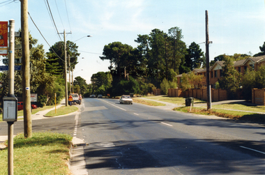
Photograph, Prior to Widening of Mitcham Road, 1/02/2000 12:00:00 AM
... Prior to Widening of Mitcham Road... to construction of widening of Mitcham Road.... to construction of widening of Mitcham Road. Prior to Widening of Mitcham ...Coloured photograph of Mitcham Road looking towards Doncaster. Hedge End Road on left, Wrendale Drive on right. Prior to construction of widening of Mitcham Road.mitcham road, donvale, hedge end road, mitcham, wrendale drive -
 Whitehorse Historical Society Inc.
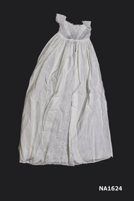
Clothing - Christening gown
Laundered 30/10/1999White cotton christening gown with short cap sleeves. Intricate embroidery down front of gown starting from small point and widening down to hem line'HN'costume, infants' -
 Kew Historical Society Inc
Plan - Subdivision Plan, J R Mathers & McMillan, Glenarbor Estate, 1934
Pru Sanderson, in her groundbreaking ‘City of Kew Urban Conservation Study : Volume 2 - Development History’ (1988), summarised the periods of urban development and subdivisions of land in Kew. The periods that she identified included 1845-1880, 1880-1893, 1893-1921, 1921-1933, 1933-1943, and Post-War Development. These periods were selected as they represented periods of rapid growth or decline in urban development. An obvious starting point for Sanderson’s groupings involved population growth and the associated economic cycles. These cycles also highlighted urban expansion onto land that was predominantly rural, although in other cases it represented the decline and breakup of large estates. A number of the plans in the Kew Historical Society’s collection can also be found in other collections, such as those of the State Library of Victoria and the Boroondara Library Service. A number are however unique to the collection.The Kew Historical Society collection includes almost 100 subdivision plans pertaining to suburbs of the City of Melbourne. Most of these are of Kew, Kew East or Studley Park, although a smaller number are plans of Camberwell, Deepdene, Balwyn and Hawthorn. It is believed that the majority of the plans were gifted to the Society by persons connected with the real estate firm - J. R. Mathers and McMillan, 136 Cotham Road, Kew. The Plans in the collection are rarely in pristine form, being working plans on which the agent would write notes and record lots sold and the prices of these. The subdivision plans are historically significant examples of the growth of urban Melbourne from the beginning of the 20th Century up until the 1980s. A number of the plans are double-sided and often include a photograph on the reverse. A number of the latter are by noted photographers such as J.E. Barnes.The little-known Glenarbor Estate comprised 23 allotments bordering Wellington and Denmark Streets and Fenton Avenue. The auction of the allotments in the Estate was held in the Kew Recreation Hall. The purported advantages to Kew are identified on the plan, such as the close proximity of the entrance to the Kew Railway Station and access to shops in Denmark Street. Due to its location, the subdivision was pitched at commercial as well as residential purchasers. The Estate was to cause a crisis in the Kew Council as a majority of councillors voted on 29 May to acquire the entire Estate as the location of a new Town Hall. The Estate was said to be valued at £50,000. A later meeting was to rescind the vote, instead opting for the compulsory acquisition of South Esk on the corner of Charles Street and Cotham Road. That acquisition was to be overturned by the State Government. The debate about the purchase of the Glenarbor Estate by Council coincided with the decision to widen High Street on the South side between Cotham Road and the Junction."D"subdivision plans - kew, glenarbor estate, wellington street, denmark street -
 Kew Historical Society Inc
Postcard, Victoria Street Bridge, Collingwood, 1905-1913
Victoria Bridge is a riveted and welded steel Warren truss bridge over the Yarra River completed in 1884 to a design by Fraser & Chase following a controversial design competition held in 1880. Funds for the bridge's construction were provided by the councils of Collingwood, Hawthorn, Kew and Richmond. The contract was awarded to Mr P. Platt. Charles Rowand was officially appointed Supervising Engineer in 1883. The winning design was based on the theoretical work of William Charles Kernot (1845-1909) who campaigned for economy in public works design and the application of scientific principles in engineering. ... The bridge was widened in 1890 by the addition of a third line of truss on new piers on the up stream side to carry horse trams. Work commenced in 1914 to convert the horse tramway to an electric tramway by the Prahran & Malvern Tramways Trust, part of the Trust's extension of its tramway into the eastern suburbs between 1913-18. In 1915 the bridge was further strengthened to accommodate the extra weight of electric trams and widened by the addition of two six feet cantilever footpaths. During this period the Prahran & Malvern Tramways Trust erected two ornamental gantries over the roadway to support overhead wires for the electric tramway. Further widening and reconditioning of the bridge took place in 1933, including the addition of four new welded trusses, two intermediate and two on the outside. The latter were supported on new cantilevered truss cross beams attached to the top of the piers. (Source: Heritage Victoria)Early and rare postcard of the Victoria Street Bridge linking Victoria Street and Barkers Road.Polychrome postcard of the Victoria Street Bridge which links Richmond and Abbotsford with Kew and Hawthorn.View from Harrison Cres embankment / former Xavier College boatshed on site of tree in foreground. / Chimney left corner - Wool Scoring Mils in Victoria St. / On horizon - Studley Villa, Studley House circa 1880s, Studley Hall / Chinese gardens to be seen behind three set of columns / M.J. Slatterypostcards -- yarra river, postcards -- bridges. -- greater melbourne (vic.), victoria street bridge -
 Kew Historical Society Inc
Photograph - Denmark Street, Kew, 1972
The Engineer's Department of the former City of Kew had an extensive collection of photograph of sites in Kew requiring documentation to inform public works. It also kept images of engineering practice in other parts of Melbourne, and overseas, that could be used as models for local activity. Many of these photographs (and plans) were donated to our collection in the 1980s. A number of the photographs are annotated, either on the image itself or on the reverse.This photograph, and others sourced from the City Engineer's Department of the former City of Kew, qualifies as an important record of local streets, public works, street beautification, and engineering techniques of the period. Original black and white photographic positive of automobiles and buildings in Denmark Street, Kew, immediately before the road enters Kew Junction. On the left is McKeon Motors and a retailer of Insulwool, while in the distance is the pharmacy on the corner of High Street and Princess Street (later demolished during the widening of Kew Junction). Notable are the bluestone guttering and what appears to be vacant land on the apex of the triangle of land bounded by High Street South, Denmark Street and Barkers Road. This site was the original location of O'Shaughnessy's 'Kew Hotel', and after the destruction by fire of the latter, the location of a service station. [It is now the site of the Cresco Reserve].Annotation verso: "Indicating the existence of a vehicular entrance at Denmark St abuttal of No.188 High St prior to reconstruction of channeling &c 1972."denmark street -- kew (vic.), kew junction, luestone gutters, mckeon motors, insulwool -
 Glen Eira City Council History and Heritage Collection
Document (Item) - Newspaper (digital), Caulfield Contact
The Caulfield Contact was the official newspaper of the City of Caulfield from 1976-1994. The City of Caulfield was the Municipal Council for an area of the South Eastern suburbs of Melbourne, including Brighton East, Carnegie, Caulfield, Elsternwick, Gardenvale, Glen Huntly, McKinnon, Murrumbeena, Ormond and St Kilda East. Following Amalgamation of City of Caulfield and parts of the City of Moorabbin in 1994, the Caulfield Contact was followed by the Glen Eira News. Includes references to the following: Children's Neighbourhood Centre Caulfield; Fire destroyed Caulfield Park Bowling Club; Naming of Harleston Park; Home Handyman Service; Profiles Councillors Peter Baitz, Ron Walters; Carnegie-Glenhuntly Football Club formed Council drops approval of rail crossings over Neerim and Glenhuntly Roads; Profiles Councillor Alwyn Samuel, Glen Richards; First stage of Nepean Highway widening; Minister approved re-subdivision; Council spills; Exciting development of Caulfield Park; Profiles Councillor Max Blair, Councillor Brian Rudzki; Tram shelter classified by National Trustcity of caulfield, caulfield, glen eira, city of glen eira, caulfield contact, children's neighbourhood centre caulfield, fire destroyed caulfield park bowling club, naming of harleston park, home handyman service, profiles councillors peter baitz, ron walters, carnegie-glenhuntly football club formed, council drops approval of rail crossings over neerim and glenhuntly roads, profiles councillor alwyn samuel, glen richards, first stage of nepean highway widening, minister approved re-subdivision, council spills, exciting development of caulfield park, profiles councillor max blair, councillor brian rudzki, tram shelter classified by national trust -
 Sunbury Family History and Heritage Society Inc.
Photograph
The single span bluestone bridge is on the Calder Highway at the base of Corkscrew Hill between Gap Road and the town of Gisborne. In the early 1990s the highway was widened and dual carriageways constructed, as a result the traffic no longer travelled along the winding Corkscrew Hill road. The bridge still stands between the two carriageways. A black and white photograph with a cream border of a single arched stone bridge spanning a watercourse. Small bushes are growing in the foreground and there are some buildings dotted across the hill in the middle distance.bridges, corkscrew hill, calder highway -
 Surrey Hills Historical Society Collection
Photograph, Surrey Hills looking south-east from the steeple of Holy Trinity Church, 1921, 1921
The property in the foreground is 'Edgeware' at 171 Union Road, a house built by the Zeplin family. It became the home / residence of Dr Percy Liddle and later Dr James Landells Blakie. By the time this photo was taken Dr Blakie had moved across the road to 174 Union Road. In the background behind the 2 houses in the foreground is the Surrey Hills Stationmaster's house, sitting behind a picket fence. The Alan Holt register gives a build date of c1915 for this house, which fits stylistically. The first stationmaster was probably Michael Ginnane, who stayed in the area after he retired, moving to 1 Russell Street. This property was listed as 8 Bedford Avenue, the only house on the south side of the road. It was demolished in c1972 to make way for widening of the rail track with a third line. The photographer Norman Carter took many photos of Surrey Hills and Mont Albert from the 1920s, in particular of events and activities associated with the Church of England.Black and white photo taken from the steeple of Holy Trinity Church looking across housing towards the railway line and Albany / Windsor Crescents and on towards Canterbury Road. Surrey Hills Primary School and St Stephens Presbyterian Church feature prominently on the horizon. The stationmaster's cottage is centre left adjacent to a large conifer-like tree, with a white fence delineating the railway yards.On back of original: "6-11-21" and in a different hand in biro: "from tower of Holy Trinity Church"albany crescent, windsor crescent, st stephens presbyterian church, surrey hills primary school, railways, stationmasters' houses, bedford avenue, norman carter, edgeware, dr percy liddle, dr james blakie -
 Brighton Historical Society
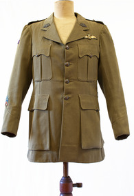
Uniform, Army jacket, circa 1914-19
First World War Army jacket belonging to Lieutenant Sydney Matthew Callaghan (1892-1976), who served in the Australian Engineers, AIF Canteens Section and the Australian Flying Corps during WWI. Sydney and his family lived at 34 Normanby Street from 1932. His parents lived in Bay Road, Sandringham.First World War Army jacket, khaki with four front pockets. Winged Australian Flying Corps patch above left breast pocket. Lieutenant's insignia on epaulets: two diamond-shaped metal 'pips' and a curving band with the word "AUSTRALIA". Flying Corps colour patch on each shoulder: a pale blue triangle with two small red stripes and a large central darker blue stripe. Metal belt hooks on either side of the waist. The garment has been widened, with a strip of khaki fabric inserted in the centre back.sydney matthew callaghan, australian flying corps, military uniform, first world war -
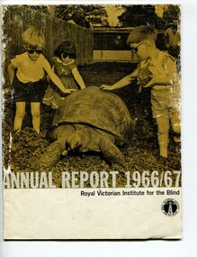 Vision Australia
Administrative record - Text, Royal Victorian Institute for the Blind annual report 1966-1967, 1966-1967
Articles in annual report include: Office bearers of the institute/officers, President's report - 100 years, Residence nursery and school for blind children - in 1866 first nine blind children were accommodated in temporary premises in Commercial Road Prahran, the budget was $822 pounds, now the facility in Burwood can house 70 children and the, budget is $160,000, New found confidence after rehabilitation, Blind welfare work increases, Our factory now serves industry, Employ opportunities are widening, Our loyal auxiliaries and other supporters, What of the future, Income and expenditure, Where there's a will there's a way to help blind people. Events that occurred in 1966 : Millet broom making was discontinued and mat and industrial brush making and packing and assembly began, the Governor of Victoria and Lady Delacombe brought their dog to visit the children at the school, the Institute began two vital new projects - providing a residential geriatric facility and to establish the RVIB foundation for research and education.1 volume of print and illustrationsannual reports, royal victorian institute for the blind -
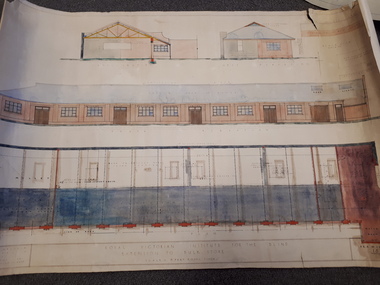 Vision Australia
Plan - Image, Royal Victorian Institute for the Blind Extension to Bulk Store, 27/8/1925 (according to Mosiac entry)
In this undated drawing, believed to have been done in 1925, an existing bluestone store was extended out into the courtyard area. The extensions were on the south and west elevations, and the drawing includes a floor plan of these areas. Noted on the plan is the removal of fireplaces that existed in this building, the location abutting the Alfred Hospital reserve and location of the motor room.1 architectural plan of extension to bulk storeStephenson & Meldrum, Architects 374 Little Collins Street Melbourne Phone: 6990 On the back: Widening of old bluestone store plans & specroyal victorian institute for the blind, plans -
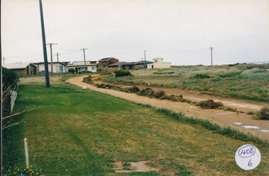 Port Fairy Historical Society Museum and Archives
Photograph
South Beach Development Coloured photograph of Ocean Drive being graded and widened408/6 since been removed (2021)south beach, development, road making, ocean drive -
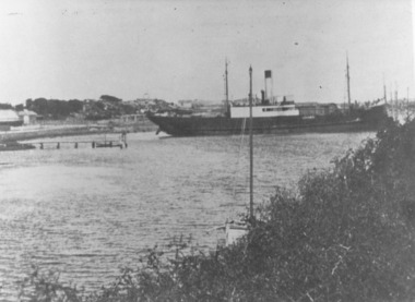 Port Fairy Historical Society Museum and Archives
Photograph
This shows the S.S.Wannon turning in the specially widened part of the river called the "turning basin" before slipping into her berth at the Belfast and Koroit Steam Navigation Company wharfBlack and white photograph of SS Wannon turning in the Moyne Rivership, boat, sea, moyne river, belfast and koroit steam navigation company, turning basin -
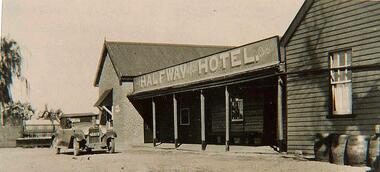 Wodonga & District Historical Society Inc
Photograph - Halfway Hotel, Wodonga
The Halfway Hotel was built c1871. It was a thriving business in the days of the bullock wagon and was virtual headquarters of border drovers and teamsters, who camped on the Wodonga Flats opposite. Mr. John Jennings applied for a license in 1871 but it was refused. In October 1872 a License was granted to Thomas Weeks who was advertising that he had purchased the premises. In December 1878 the licensee was advertised as Ann Weeks. Daniel McCormick took over as licensee in 1882 and was followed by Thomas Fitzgerald. In September 1886, Fitzgerald transferred the licence of the hotel which contained eight rooms, to Patrick Flanagan. Flanaghan was a hotel keeper, brewer and stock trader. Pearce Murphy became licensee in 1889, followed briefly by his wife, Julia, in 1890. In September 1890, the licence was transferred back to Patrick Flanagan, the hotel’s owner. During the 1890s, the licence changed hands a number of times. Licensees included Alexander McDonald, Mrs Spehrs, George and Mary Rust. In December 1895, George Rust held the ‘Halfway Races’ on a course at the back of the hotel. Towards the end of the 1890s, Patrick Flanagan was again licensee of the hotel. He died in his residence at the Halfway Hotel in 1929. The license was then held for two years by his son, Mr M.J. Flanagan. In June 1931 the licence was transferred from Maude J. Flanagan to Percy Pickering. In July 1939 the hotel was sold by Mr P.W. Pickering to Irene Weatherall. The new licensee was Mr H.O. Harris of Bonegilla. In April 1940 The Licensing Court granted an application to remove the Halfway Hotel, Albury Road, Wodonga, to the corner of Elgin and Smythe Streets, Wodonga, on condition that premises were to be erected within 42 weeks. Applicants were Irene A. Weatherall and Lena Emma Pickering, owners, and Harold O. Harris, licensee. Mr Edwin Harold and Mrs Ruby Scholz bought the property. Ruby was a sister of Emma Pickering. They lived there until the premises was demolished for the widening of the Lincoln Causeway. These images document an early business in Wodonga c1870 to 1940.A black and white image of a hotel building.Above building: HALFWAY HOTELhalfway hotel, wodonga hotels, wodonga businesses -
 Wodonga & District Historical Society Inc
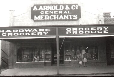
Photograph - A. Arnold General Merchants, Wodonga
In 1924, Arthur Arnold and his father Wilhelm Arnold had established a general store in High Street, near the water tower, but in 1931–32 they moved to new premises in High Street on the corner of what is now known as Elgin Boulevard. In 1933-34 they widened the frontage of the shop and added new premises at the rear for the sale of produce. The Arnolds continued to trade until they finally closed their store in 1950. Wilhelm Arnold was a brother of J G Arnold, whose business ultimately became the present-day Arnold’s Fruit Market, Wodonga.This is an image of an early Wodonga businessman who was also active in the communty.A black and white image of 2 children looking through the window of Arnold's store. A newspaper advertisement for the company is also included.Above Shop: A.ARNOLD & Co. / HARDWARE - GROCERY/ CROCKERY - PRODUCEwodonga businesses, a arnold general merchant -
 Wodonga & District Historical Society Inc
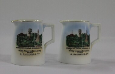
Memorabilia - China Souvenir Jugs Woodland Grove Wodonga, c. 1940
A wide range of small china pieces carrying scenic views of holiday destinations or key locations were a popular kind of souvenir during much of the 20th century. Several different pieces were used to depict Wodonga during this period, primarily focusing on the Woodland Grove and the Soldier Memorial. In 1924, Arthur Arnold and his father Wilhelm Arnold had established a general store in High Street, near the water tower, but in 1931–32 they moved to new premises in High Street on the corner of what is now known as Elgin Boulevard. In 1933-34 they widened the frontage of the shop and added new premises at the rear for the sale of produce. As customer debt mounted during the depression, it became difficult for Arthur and Wilhelm to re-stock the shop, so they enticed customers into paying their accounts by rewarding them with a small individual cream or milk jug upon payment. The jugs were made in Czechoslovakia and displayed the war memorial, water tower and bandstand from Woodland Grove, Wodonga. The Arnolds continued to trade until they finally closed their store in 1950. Wilhelm Arnold was a brother of J G Arnold, whose business ultimately became the present-day Arnold’s Fruit Market, Wodonga. This item has local historic and social significance as it depicts which features of the city the community valued in the past. It has artistic significance as an example of the kinds of souvenirs used widely across Australia to represent communities and the landscape.A pair of miniature white jugs with a gold rim and handle detailing. A hand-coloured transfer image fills the front side depicts Woodland Grove Wodonga, including the Soldiers' Memorial, Water Tower and RotundaBeneath the image : "WOODLAND GROVE, VIC. / With Compliments/ from/ A. Arnold & Co."wodonga, souvenirs, woodland grove, ceramics, arnolds wodonga -
 Wodonga & District Historical Society Inc
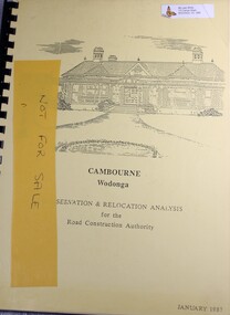
Booklet - Cambourne Wodonga : Conservation & Relocation Analysis for the Road Construction Authority, John & Thurley O'Conner, 1987
Research paper into the viability of relocating Cambourne Homestead in 2006 in order to make way for the widening and upgrade of the Hume Highway.non-fictionResearch paper into the viability of relocating Cambourne Homestead in 2006 in order to make way for the widening and upgrade of the Hume Highway. cambourne homestead wodonga, heritage building wodonga, carkeek family, potter family, building relocation -
 Eltham District Historical Society Inc
Photograph, Cottage, corner Main and Reynolds roads, Research, Vic, 1986
... widening of Main Road..... Three views show widening of Main Road. Cottage, corner Main ...Wal and Bernie Dodkins, rented the house from Miss Reynolds probably from around 1938 until they left in the 1970s to become caretakers at the Kangaroo Ground Tower. Lyn Dodkins (wife of Graeme Hardiman) was born there and lived in this house for her first 19 years. [Graeme Hardiman email 5 Aug 2022]Six colour photographs of old cottage corner Main and Reynolds roads at Research in 1986. The cottage was built by/for Grandfather Reynolds and was demolished 2 Mar 1987. Three views show widening of Main Road.houses, main road, reynolds road, research (vic.), lyn dodkins, wal dodkins, bernie dodkins, miss reynolds -
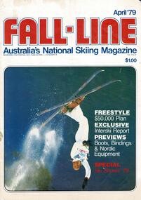 Falls Creek Historical Society
Magazine - Fall-Line - Australia's National Skiing Magazine April '79
“Fall-Line” was one of a series of magazines published by the Victorian Ski Association. It was produced from 1979 until 1985. It superseded their previous publication, “Ski” magazine and was followed by the “Australian Skiing” magazine. The Victorian Ski Association was formed in 1955.This magazine is significant because it documents developments in the ski industry in Australia.A magazine featuring a coloured image on the cover and containing articles and advertising related to developments in skiing in Australia. This issue included an update on improvements being made at Falls Creek. FALLS CREEK The chairlift access area near the medical centre, long famous as the Mudpie Parlour of Falls Creek, has been sealed and Falls Creek itself, the waters of which have filled many an unsuspecting gum- boot, has been bridged, also near the medical centre. A lock-up storage shed will be built along Bogong High Plains Road, just below the oversnow terminal, for the use and convenience of all village commercial operators and site holders. Direct access will be possible by snowmobile. Falls Creek rates have risen to $82.50 per bed (less 10% discount if paid on time). The rise is the first in two years, and is less than the corresponding rise in the C.P.I. over that period. The access trail from the water tanks at the base of the Home Trail to the nursery slope has been smoothed and widened to 12 metres, and a new six metre wide access trail has been cut from Falls Creek Road, just behind Diana lodge to the chairlift bottom station. The Village Bowl comfort station is being extended and renovated, and the finishing touches are being put on the comfort station in the upper car park. Construction of an akja station/toilet block in Sun Valley will commence in 1980. The Management Committee is investigating the purchase of a Mercedes 800 series snow-clearing machine to supplement the CRB equipment in use in village parking areas The village water supply has been re- designed to ensure adequate supply at all times.australian ski magazines, skiing australia, victorian ski association -
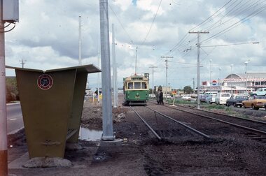
 Melbourne Tram Museum
Photograph - Last day of original Essendon Airport tram terminus, Ron Scholten, 7-10-1976
The original line to the Essendon Aerodrome was constructed in 1943 to serve the airport and aircraft construction. It was funded by the Commonwealth Government. By 1976, patronage to the airport terminus in Vaughan St had dropped, the crossing of the highway to the Tullamarine Airport opened in 1970, was dangerous, and the highway needed to be widened. The new terminus was a short distance to the north between Mathews Ave and the Highway. This series of photographs show the last day of operations to the original terminus and the changeover, which was done in about 7 hours. No buses were required. It was done by workers of the Melbourne and Metropolitan Tramways Board. The line was later extended to Airport West. .1 - W5 789, (Essendon Airport Route 59) about to turn from Mathews Ave into Vaughan St. Has new track and footbridge in the foreground. .2 - W5 791 on the siding or spur at the airport terminus, the last tram to use this facility. .3 - W2 571, at the Airport terminus alongside Vaughan St on the last morning of the use of this terminus. The Bundy clock can be seen behind the pole on the lefthand side and the Brick passenger shelter. Shows buffer stops, and Forestair hanger behind. .4 - W2 595 turning from Vaughan St into Mathews Ave. Has the tram stop No. 55 in the view. .5 - W5 839 turning from Vaughan St into Mathews Ave. Shows the flashing yellow light that gave some protection to the trams. .6 - W2 247 about to turn into Vaughan St. Driver about to reboard the tram. Note the new copper trolley wire is up for the new track but has been pulled to the west side using rope. .7 - W5 805, turning from Mathews Ave into Vaughan St, to the old Essendon Airport terminus. Has a new track in the foreground, and the overhead for the curves is still in position. .8 - W6 991 turning from Vaughan St into Matthews Ave, at 855am, the last tram from the old terminus. The track gang has commenced work to remove the outbound curve. Would appear four passengers waiting at the tram stop, two with lunch bags. Note the cattle grid in the foreground between the rails. New rails on the ground on the left-hand side. See Reg Item 6163 for further photos of this event.Yields information about the last day of the operation of the original Essendon Airport tram line.Set of 8 Kodachrome cardboard mount colour slides of the relocation of the Essendon Airport tram terminus 7-10-1976, by Ron Scholten.All slides have detailed descriptions on the reartrams, tramways, essendon aerodrome, essendon airport, closure, new tramways, route 59, w5 789, w5 791, w2 571, w2 595, w5 839, w2 247, w5 805, w6 991, w2 class, w5 class, w6 class, mmtb, trackwork -
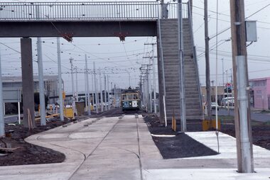
 Melbourne Tram Museum
Photograph - Changing the Location of the Essendon Airport terminus, Ron Scholten, 7-10-1976
The original line to the Essendon Aerodrome was constructed in 1943 to serve the airport and aircraft construction. It was funded by the Commonwealth Government. By 1976, patronage to the airport terminus in Vaughan St had dropped, the crossing of the highway to the Tullamarine Airport opened in 1970, was dangerous, and the highway needed to be widened. The new terminus was a short distance to the north between Mathews Ave and the Highway. This series of photographs show the operation of a tram service during the changeover. Trams ran from the Niddrie crossover near Keilor Road to a temporary terminus just short of the worksite, with cars running "bang" road or the wrong way for one trip along either line. This would have been controlled by an Inspector at the Niddrie end. The work was done over a 7-hour period, including changing the overhead over. Work would have been completed after the changeover period. .1 - W5 800 at “temporary” Essendon Airport terminus, Cnr Mathews Ave, Vaughan St. after running “bang” road or the wrong way to this point from the Niddrie or Keilor Road crossover. Curves have been removed.. Has an Inspector chatting to a man with a hat standing alongside the tram. The shelter has a City of Keilor logo on it. .2 - W5 684, taken from the overbridge at the TAA stop - during the changeover of the tracks. Tram running “bang” road from Niddrie to the temporary terminus. .3 - SW5 787, temporary terminus in Mathews Ave, about to return to Niddrie as an “up” car on the “down” line. .4 - MMTB Track gang commissioning and placing rails at the new terminus with scrubber 10 waiting. Overhead in position with overhead for the curves partly removed. Mobile Crane on the left-hand side moving a formwork piece into position .5 - 10W cleaning new track at the new terminus. .6 - Rail Scrubber 10W at work cleaning head of rails where new concrete section. Has a TAA bus on the right side. .7 - W5 783 is about to be the first passenger tram to the terminus, at 3.50 pm About 20 workmen are completing the inbound or up track. .8 - W5 783 about to be the first passenger tram to the terminus, at 3.50 pm About 20 workmen are completing the inbound or up track.Yields information about the last day of the operation of the original Essendon Airport tram line and the works done for the new terminus.Set of 8 Kodachrome cardboard mount colour slides of the relocation of the Essendon Airport tram terminus 7-10-1976, by Ron Scholten. All slides have detailed descriptions on the rear trams, tramways, essendon aerodrome, essendon airport, closure, new tramways, route 59, mmtb, trackwork, w5 800, w5 684, sw5 787, scrubber 10w, w5 783, w5 class, sw5 class, taa airlines, city of keilor -
 Melbourne Tram Museum
Album - Photo Album, Michael Schrader, General tramway photos, 1995 - 1997
Album - comprising 23 plastic photo holders in a interleaved pack glued to a heavy plastic sheet covered folder. Matching image and sheet numbers .1 - overhead issue at intersection of Riversdale and Glenferrie Road with parked trams. .2 - University terminus under construction (Dec. 1995) showing track layout and Bendigo tram 808 on City Circle outside Spencer St station and Bourke St. - 1995. .3 - New Exhibition Centre (Jeff's Shed) and trams 852 and A292 in Clarendon St. - Feb. 1996 .3a - Y469 on Zoo Tourist tram - 2/1995 and at the zoo. .4 - Y469 and Z3 200 at the zoo cross over and 469 using the cross over. .5 - Y469 crew photo and overhead work following trackwork in Domain Road at Domain Junction. .6 - Short shunts and bus replacements for Domain Junction works - Z69 and buses. .7 - Volvo bus 89 in Swanston St (replacement) an a view of the Burke Road overpass of the Freeway at Gardiner nearing completion. .8 - ditto showing the new widened level crossing at Gardiner and trams in the distance. Opened Dec. 1995. .9 - Photos showing widening of the freeway at Gardiner and relocation of the creek. .10 - Photos showing the construction of the turnout into the new Southbank Depot - cFeb. 1997. .11 - Photos of four trams and others at South Melbourne depot (closed 8/2/1997) including 981, 954, 923 and 1005 prior to fan trip to move the trams to Malvern Depot. .12 - Photo of one of the trams leaving the depot and two on Queensway Prahran. .13 - Trams 843 and 920 at South Melbourne and 843 and others at Whiteman St shunt. .14 - Tram 843 at Southbank depot entrance on the Port Melbourne Line. .15 - Restaurant trams 442, 937 and 939 at Southbank and tram 114 in Swanston St at Batman Ave. .16 - Z8 leads a fleet of Z class trams in Swanston St and Batman Ave and a large number of buses lined up in Spencer St - Grand Prix tram strike - 1997 .17 - buses buses - Latrobe St and Swanston St. .18 - ditto .19 - Relaying Hawthorn Bridge and relaying Dandenong Road .20 - Track relay Dandenong Road - centre median reserved track with rail wagons .22 - ditto .23 - lifting track into place. Two loose photos - Bundoora terminus, Grand Prix services and Grand Prix information booth.trams, tramways, mmtb, overhead, riversdale rd, glenferrie rd, university, spencer st, city circle, clarendon st, y class, z3 class, a class, trackwork, domain junction, swanston st, burke rd, gardiner, southbank, south melbourne depot, queensway, restaurant tram, dandenong rd, grand prix, bundoora, tram 808, tram 892, tram 292, tram 920, tram 200, tram 69, tram 981, tram 954, tram 923, tram 1005, tram 843, tram 442, tram 937, tram 939, tram 114 -
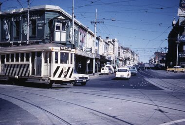 Melbourne Tram Museum
Slide - Scrubber 11 St Kilda Junction, Tramway Museum Society of Victoria (TMSV), early 1960s
Colour slide of Scrubber or rail cleaner No. 11 turning from Wellington Street St Kilda into St Kilda Road. Shows the signal box above the awning of the licensed grocer. In the view are R T Taylor Licensed Grocer and Brookes store. The Junction Hotel can just be seen on the right. Shows High St which was later widened. Yields information about St Kilda Junction and the signal box.Kodachrome colour slides, cardboard mount, duplicate.Stamped "Tramways Museum Society Victoria". In pencil "Old Junc note Junc box" and number "MP100"tramcars, scrubber tram, scrubber 11, st kilda junction, wellington st, high st, signal box -
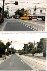
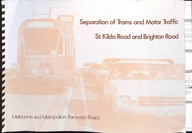 Melbourne Tram Museum
Document, Melbourne & Metropolitan Tramways Board (MMTB), "Separation of Trams and Motor Traffic - St Kilda Road and Brighton Road", May 1979
... the widening of St Kilda Road south of Cochrane St and its impact. Has... the widening of St Kilda Road south of Cochrane St and its impact. Has ...Document prepared to provide the concepts for separation of traffic along St Kilda Road and Brighton Road using safety bars, and reserved sections of roadway between Princes Bridge and Glen Huntly Road. Dated May 1979. Has an introduction, and notes the widening of St Kilda Road south of Cochrane St and its impact. Has colour photo of Z89 in Nicholson St where the Safety bars had been installed to separate traffic, installation of Safety Zones, photos of Gothenburg, Amsterdam, and Hanover showing traffic separation, graphs showing tram passenger movement in the am peak and road usage. Looks extensively at the Domain Interchange at Park and Domain Road and the suggested layout - which was implemented in Nov. 1986. Includes a photo of a very long line of trams northbound at this intersection which has undergone many changes location, to become during 2025 the entry to Anzac station. Six drawings show the proposed separation of traffic between Alexandra Ave and Glen Huntly RoadDemonstrates a planning document to separate road traffic from trams along St Kilda Road.Comb bound document titled "Separation of Trams and Motor Traffic - St Kilda Road and Brighton Road" - 12 sheets + card covers, some full colour pages with some sheets folded.tramways, st kilda road, traffic control, domain interchange, domain road, reserved track -
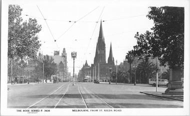 Melbourne Tram Museum
Postcard, Rose Stereograph Co, "Melbourne from St Kilda Road", late 1930s
Rose Series postcard No. P 3636, titled "Melbourne from St Kilda Road", looking north from just south of Alexandra Avenue. Note how the tram tracks are widened to pass around the center of the road light standard which appears to be marked as a tram stop. In front of the photo, a tram crossover can be seen. There is a tour bus parked at the start of Alexandra Avenue. See item 8044 for a similar view. The Edmund Fitz Gibbon Memorial is on the right in its original position in St. Kilda Road.Yields information Swanston Street and St Kilda Road in the late 1930s.Postcard - printed real photograph with Rose Stereograph Co. name on the rear.tramways, trams, st kilda road, alexandra ave -
 Melbourne Tram Museum
Letter, Australian Electric Traction Association (AETA), "Proposal to build a tramline down Nepean Highway to Southland", May. 1977
Letter with supplementary document - "Proposal to build a tramline down Nepean Highway to Southland", advocating residents support a study into a possible tram line to Southland, May 1977. The Nepean Highway was being widened at the time. Produced by the AETA. Printed by duplicating process on white foolscap paper.trams, tramways, public transport, mmtb, proposals, moorabbin -
 Eltham District Historical Society Inc
Photograph, Looking north across the Fitzsimons Lane Bridge over Yarra River between Eltham and Templestowe, c.1985, 1985c
Turnoff to Candlebark Park on right. The bridge over the Yarra River was initially opened September 22nd, 1961. Newspaper reports at the time of opening stated it linked Bolton Street, Eltham, with Fitzsimons Lane, Templestowe. In 1955 the Country Roads Board (CRB) produced survey plans that showed proposed land acquisition for the future bridge and road approaches. The 1955 plan shows that it was proposed to connect Fitzsimons Lane with Bolton Street in Eltham by a diagonal road across the river. The road connection would then continue along Bolton Street to Main Road. Prior to construction of the bridge the CRB modified the proposal significantly so that there was a new road parallel with Bolton Street and then curving to join Main Road at what was then its intersection with Old Eltham Road. This involved significantly more land acquisition and altered the pattern of land subdivision through this corridor. Initially the new road was just a single two-way carriageway as it would have required a significant widening of the cutting on the Shire of Eltham side of the river. The road was officially un-named but was known locally as the Eltham-Templestowe Road. The 1966 Melway street directory and other 1960s editions also listed the road as the Eltham-Templestowe Road. In December 1970, Eltham Shire Council, in pursuance of the provisions of the Local Government Act, named it Templestowe Road. The road was renamed Fitzsimons Lane around 1984 in conformity with the section south of the river. In 1991 a new bridge was built to the west of the original bridge. Fitzsimons Lane was widened to four traffic lanes although on the Eltham side this was done within the limits of the existing cutting. NEW BRIDGE STARTS THEM EXPLORING Without any fanfares, Country Roads Board workmen on Friday afternoon put the finishing touches to the approaches, removed the barricades, and let the traffic roll over the new Yarra bridge linking Bolton Street, Eltham, with Fitzsimons Lane, Templestowe. Over the week-end many “bridge watchers” who were making one of their periodic inspections of the progress on the new bridge found to their surprise that they could drive over it, so that people who had gone for a run out to Eltham suddenly found themselves wandering through Templestowe and Doncaster. By Monday the word of the bridge’s opening had got around sufficiently for many regular travellers to the city from Eltham and beyond to vary the monotony by going to town via Templestowe and Kew instead of through Heidelberg. They were surprised at the distances – about 3 ½ miles from Eltham to Templestowe, 6 miles from Eltham Shire hall to the Lower Heidelberg Road-Banksia Street intersection. NEW NEIGHBOURS For people on both sides of the river, the new bridge has turned distant friends into near neighbours. A Greensborough man on Sunday took 35 minutes to reach the home of a friend in East Doncaster, but the return trip over the new bridge took only 17 minutes. It will be some time yet before most people work out the possibilities in shorter and quicker trips form the north-eastern areas to the eastern and south-eastern suburbs. The coming of the warmer months will soon teach many, though the short cuts to Peninsular beaches and eastern suburban drive-ins. And before very long it is likely there will be a Tramways bus running from Templestowe to Eltham station. NEW BRIDGE STARTS THEM EXPLORING (1961, September 27). The Diamond Valley News (News clipping held in SEA_74-1_047) The previously un-named road between Main Road and Yarra River, Eltham South, east of Bolton Street was named Templestowe Road, December 15, 1970 NAMING OF STREETS AND ROADS. (1970, December 15). The Diamond Valley News (News clipping held in SEA_74-2_022)Colour photographinfrastructure, shire of eltham infrastructure, bridge, fitzsimons lane bridge, yarra river, candlebark park, red nose day