Showing 3605 items
matching street map
-
 Ringwood and District Historical Society
Poster, Land Sale Advertisement - Pinemont Estate, Ringwood, Victoria - circa 1924
Map of residential allotments for sale, with terms of sale, summary of subdivision features and local services and facilities, and photographs of local street scene and lake (Loughnan's Lake - location not marked), Subdivision includes Wonga Road (later Loughnan's Road), Glenvale Road, Kubba Road, Felix Crescent, Summit Crescent, Pine Crescent, Aurum Crescent, Hygeia Parade, Panorama Avenue, Avalon Grove, Montalbo Road, Cielterre Avenue. Sole Agents T.M. Burke Pty Ltd, 340 Collins Street Melbourne Phones 6294, 6779. Map by S. Callanan, Licensed Surveyor, 107 Elizabeth Street Melbourne. Date of poster estimated from railway services information extract " ... 36 fast electric trains to Flinders Street daily ... proposed electrification to Croydon ..." . Timeline for electrification of Lilydale Line record indicates Box Hill to Ringwood January 1923, Ringwood to Croydon November 1924 (Source: History of Croydon - McGivern, Vol.1 p20). -
 Ringwood and District Historical Society
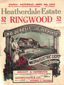
Pamphlet - Land Auction Brochure, Heatherdale Estate, Ringwood, Victoria - 1919
Double sided leaflet advertising subdivision site, layout of streets and allotments, summary of local features and services and terms of sale. Inset photographs of local views and residence of F.W. Purches on the Estate.Auction Saturday September 6th, 1919. 52 Lots. Subdivision includes White Horse Road, Witt Street, Mitcham, Station Street (later Victory Street, Mitcham). (Railway Avenue marked on the map did not eventuate). Agents - Knight & Harwood, 315 Collins Street, Melbourne in conjunction with Godbehear & Co, Phone Ringwood 49, selling through their auctioneer - Sydney T. Haynes. Solicitor W.H. Peers, 395 Collins Street, Melbourne. -
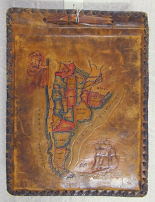 Mission to Seafarers Victoria
Album - Photographic album, Allan Charles Quinn
This photo album documents the voyage of Allan Quinn while he was in the merchant navy. The album and photos give a view of Quinn's trips around the world and the many places he visited. Leather-bound photo album. Cover is embossed with a colour map of South America.The cover contains the map of South America with a picture of a man with a pipe in his mouth in the top left-hand corner and a picture of a sailing ship in the bottom right. The inside front cover lists in handwritten columns: ports of call during 1947-48. There are three loose photos inside the front cover. album, photos, allan quinn, tourism, seafarers, sailors, seamen, ships -
 Phillip Island and District Historical Society Inc.
Booklet, Phillip Island Holidays Development Pty Ltd, Ideal Summerland on the Nobbies, Phillip Island, Late 1920s
Subdivision of Summerlands commenced in the 1920s with 12 large allotments created, along with features such as a roundabout and cypress trees. Between 1927 and 1931, 227 new blocks were created, and from 1929 to 1940 there was a nine-hole golf course on what is now the Penguin Parade car park.Historical Large 8 page glossy booklet advertising Summerlands Estate, describing attractions of the area ,maps, houses , golf course. Basically black and white with some orange print and a coloured map.Ideal Summerland on the Nobbies Phillip Island. "The land of somewhere we long to go". Published by Phillip Island Holidays Development Pty Ltd. 6o Market Street, Melbourne.housing, tourism phillip island, summerland estate -
 Phillip Island and District Historical Society Inc.
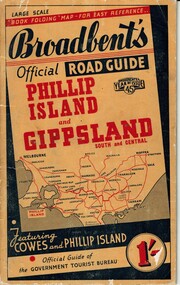
Booklet, Broadbent's Official Roadguide Phillip Island and Gippsland 45, c. 1945
Broadbent's was the official guide of the Government Tourist Bureau. Mr Roy Bain owned a secondhand shop on corner of Thompson Ave and Chapel Street, Cowes, currently a Japanese restaurant.HistoricalSmall orange, black and red booklet with black type containing maps and information of accommodation, businesses and tourist venues.Broadbent's Official Road Guide Phillip Island and Gippsland South and Central. Broadbent's Year of Issue 45.guesthouses, broadbent's guides, hislop newsagency, underdown strawberry farm, osterlund fishing trips, parry's butcher, athenia cafe, roy bain, broadway bakery, cowes camping ground, cowes main garage, beach park camp -
 Phillip Island and District Historical Society Inc.
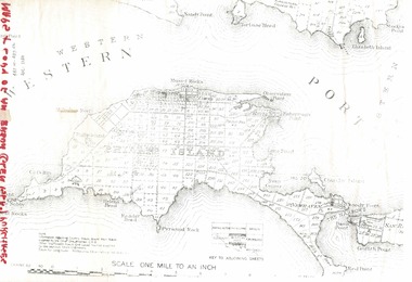
Document, 1869 Crown Land sale and map of Phillip Island showing allotments
Anderson and McHaffie were prominent early settlers of Phillip Island. These documents were from the estate of Stan Mcfee snr. Listings of auctions at Gemmell, Tuckett & Co., Collins Street, Melbourne 12 February, 1869HistoricalCopy of map showing allotments for 1869 land sale and hand written note showing allotments, area, prices for purchases of Robert Anderson and notes on McHaffie land.robert anderson, glen isla, john mchaffie, maps, land sales -
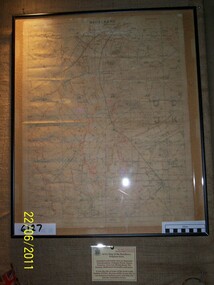 Rye RSL Sub Branch
Map Trench waterproofed cloth
A waterproofed cloth trench map of the Becelaere area, including Polygon Wood and other severely contested areas. -
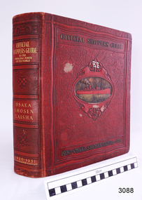 Flagstaff Hill Maritime Museum and Village
Book - Reference, M. Franklin Kline, Official Shippers Guide, 1930
This book has information about shipping companies and the world's ports. It was a handy guide for travellers of the time and included how and where to board ships going to various countries in 1930 & 1931. In effect, it was a reference work like a timetable for shippers and travellers alike.The book has maps depicting N.Y.K. shipping lines all over the world, indexes (including advertisers), and is thumb-indexed. This book is an official guide that supplies vast information for ships and shipping lines but also for tourists of the time. These types of reference works are keenly collected today.Official Shippers Guide reference book to the Principal Ports of the World, OSAKA SHOSEN KAISHA, 1930 – 1931, Seventeenth Edition, edited, compiled and designed by M. Franklin Kline. Large, hard covered, bound book with margin thumb tabs. Covers are dark red with gold lettering and embossed pattern. Centre of front cover has an oval image of a red steam ship on a gold sea. Above the ship is a white flag with a red emblem.flagstaff hill, warrnambool, flagstaff hill maritime museum, maritime museum, shipwreck coast, flagstaff hill maritime village, great ocean road, traveller's guide, shippers guide, osaka shosen kaishaguide, guide to world ports, m. franklin kline -
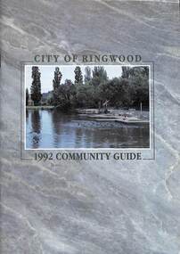 Ringwood and District Historical Society
Book, City of Ringwood, City of Ringwood 1992 Community Guide, 1992
Community information book issued by City of Ringwood for 1992 - covering the facilities and activities of the Ringwood Council and other local organisations and associations. Includes two Aquatic Centre entry vouchers valid until June 30th, 1992.CONTENTS: (page no.) 1991/92 COUNCIL REPRESENTATIVES 4 1992 CALENDAR 51 AQUATIC CENTRE 8 AQUATIC CENTRE VOUCHERS 49 CHIEF EXECUTIVE'S REPORT 6 CIVIC CENTRE TELEPHONE INDEX — DIRECT DIALLING 53 COMMUNITY DIRECTORY 35-47 COMMUNITY SERVICES 17-19 COUNCIL & COMMITTEE CYCLES 4 COUNCIL FINANCES & 1991/92 RATES 16 COUNCILLORS 3 FUNCTIONAL RESPONSIBILITIES 15 HISTORY OF RINGWOOD 5 HOUSING & RESIDENTIAL DEVELOPMENT 29-30 INFRASTRUCTURE 34 LOCAL, STATE & FEDERAL GOVERNMENT ELECTIONS 32 MANAGEMENT TEAM 14 MAYORAL MESSAGE – Cr. Max Williams 1 NEIGHBOURHOOD MAP 26-27 NOTES 52 PAPER & CARDBOARD COLLECTION SERVICE 22 PARKS & RESERVES — PUBLIC FACILITIES 31 PROTECTING OUR COMMUNITY 23-24 PROTECTING THE ENVIRONMENT 20-21 RINGWOOD FESTIVAL & HIGHLAND CARNIVAL 13 RINGWOOD GOLF COURSE 7 STRATEGIC BIKE PLAN 11 STREET INDEX A-L 25 STREET INDEX L-Z 28 THE LIBRARY 12 THE RINGWOOD CONVENTION & PERFORMING ARTS CENTRE 10 TRAFFIC MANAGEMENT 33 YOUR PERSONAL DIRECTORY 50 rinx -
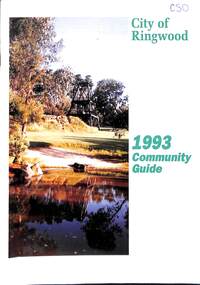 Ringwood and District Historical Society
Book, City of Ringwood, City of Ringwood 1993 Community Guide, 1993
Community information book issued by City of Ringwood for 1993 - covering the facilities and activities of the Ringwood Council and other local organisations and associations. Includes two Ringwood Aquatic Centre bonus entry vouchers valid until June 30th, 1993. Cover photographs: Front - Poppet Head, Ringwood Lake; Back - Opening of North Ringwood Child Care Centre. CONTENTS: (page no.) Message from the Mayor – Cr. Greg Adkins, J.P. 3 Councillors 4 Council & Committee Cycle 5 Council Elections 6 History of Ringwood 7 Chief Executive's Report 8 The Management Team 9 Functional Responsibilities 10 Community Liaison 11 Council Expenditure for 1992/93 12 Rates and Valuations 13 COUNCIL SERVICES Community Services 14 Protecting the Environment 17 Protecting Our Community 19 Town Planning 21 Building 22 Design and Investigation 23 Works 24 Street Index - Electoral Wards 25 Neighbourhood Map 26 and 27 COUNCIL RECREAION AND LEISURE FACILITIES Ringwood Golf Course 29 Aquatic Centre 30 The Ringwood Convention Centre 32 Ringwood Library 34 Ringwood Recreation 35 Parks and Reserves 30 Community Directory 38-50 Community Information Data Bank 51 Aquatic Centre Vouchers 51rinx -
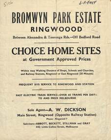 Ringwood and District Historical Society
Flyer, Bromwyn Park Estate, Ringwood - 1946 - Avertising Brochures and Map
Two pages of subdivision features, services and locationSubdivision plan includes Alexandra Road, Marwarra Street, Tooronga Road, Hilary Grove, Morcom Avenue. -
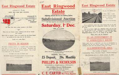 Ringwood and District Historical Society
Flyer, Subdivisional Auction Sale Brochure, East Ringwood Estate, Vic. - 1923
Tri-folded double sided advertisement for subdivisional auction sale on Saturday, 1st December, 1923, including location map and summary of local facilities and services.Subdivision includes Patterson Street, Bona Street, Miller Grove, Fairview Avenue and Eastfield Road. Auctioneer - Phillips & Nicholson, 281 Collins Street, Melbourne. Tel. Central 10907. Agent - C.E. Carter, Main Street, Ringwood. Tel. Ringwood 24. -
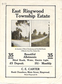 Ringwood and District Historical Society
Flyer, Subdivisional Land Sale Brochure, East Ringwood Township Estate, Vic. - 1923
Bi-folded double sided land subdivision sale advertisement with location map and summary of local facilities and services. Includes two additional images of allotment plan with subsequent handwritten notations.Subdivision includes Mount Dandenong Road, Grey Street, and Eastfield Road. Agent - C.E. Carter, Bank Chambers, Main Street, Ringwood. Phone Ringwood 24. -
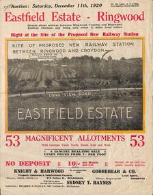 Ringwood and District Historical Society
Flyer, Subdivisional Land Auction Sale Brochure, Eastfield Estate, Ringwood, Vic. - 1920
Bi-folded double sided land advertisement for subdivision auction on Saturday, December 11th, 1920, for Eastfield Estate with location map and summary of local facilities and services.Subdivision includes Croydon South streets - Eastfield Road, Long View Road, The Mount, and Pleasant Rise. Local Agent - Godbehear & Co, Phone Ringwood 49. -
 Ringwood and District Historical Society
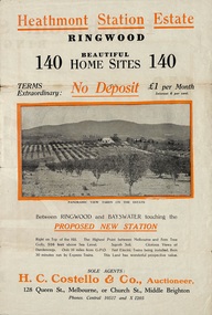
Flyer, Land Sale Brochure, Heathmont Station Estate, Ringwood, Vic. - circa 1925
Extract of "Herald" 2/2/22: The intention of the Railway Commissioners is to electrify the line to the Gully as soon as convenient, and with greater frequency of service many persons settled, and settling, in the district will be benefited. There is a scheme which may be launched that will allow for an express service of fast trains to the Gully. The commissioners are alive to the necessity for assisting to settle the picturesque districts between Box Hill and Gembrook.Bi-fold advertisement for sale of retail and residential sites, including panoramic and other photographs, map, and summary of subdivision features and local facilities. Subdivision includes Canterbury Road, Station Street (later Wainui Avenue), Lisgoold Street, Viviani Crescent, and Balfour Avenue. Agent - H.C. Costello & Co., Auctioneer, 128 Queen Street, Melbourne, or Church Street, Middle Brighton. Phones: Central 10517 and X1205. -
 Ringwood and District Historical Society
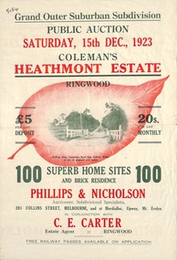
Flyer, Land Sale Brochure, Coleman's Heathmont Estate, Ringwood, Vic. - 1923
Bi-fold advertisement for auction sale of residential sites, including photographs, map, and summary of subdivision features and local facilities. Auction date Saturday 15th December, 1923. Subsequent auction date Saturday 19th January, 1924, following previous sale stopped on account of rain. Initial newspaper advertisement (publication unknown) dated 16/11/23.Subdivision includes Bedford Road, Canterbury Road, Alvena Crescent, Leonard Street (later Royal Avenue), and Coleman Street. Agent - Phillips & Nicholson, 281 Collins Street Melbourne, (Phone) Central 10907, in conjunction with C.E. Carter, Main Street, Ringwood. Tel. Ringwood 24. -
 Ringwood and District Historical Society
Flyer, Land Sale Brochure, Heathmont Estate, Vic. - circa 1960
Advertisement for sale of residential lots - Heathmont Estate, opposite Heathmont Railway Station, with map and locality plan.Subdivision includes Canterbury Road, Royal Avenue, Coleman Street, Stoda Street, Herman Street, and Campbell Street. Agent - A.W. Dickson, opposite Station, Ringwood. Phone WU6007. -
 Ringwood and District Historical Society
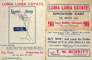
Flyer, Land Sale Brochure, Loma Loma Estate, Ringwood East, Vic. - circa 1924
Flyer includes extract from "The Sun" 30/10/1924. "Ringwood has been created a Borough with capital value of £680,000. In 1908 there were 173 houses, 8 shops and 720 people. In 1918 the respective figures were 520, 45 and 2,080. For twelve months ended June, 1924, £51,000 worth of Home Sites were sold and £26,000 worth of new buildings were erected. Outward (train) passenger journeys have increased from 94,000 in 1919 to 182,000 in 1923. Train services have been almost doubled and time to Melbourne reduced from 60 to 37 minutes."Bi-fold double-sided land sale advertisement for Loma Loma Estate, Ringwood East, including area map, layout of the estate, and summary of local facilities and services.Subdivision includes Loma Street, Highton Street, Morinda Street, and Station Street (later Railway Avenue) Ringwood East. Agent: T.W. Burkitt, Ringwood, Phone Ringwood 157. -
 Ringwood and District Historical Society
Flyer, Executor's Auction Subdivision Advertisement, Lilydale Road and Oban Road, Ringwood East, Vic. - 1937
Single page advertisement for Executor's Auction of land in Ringwood East on Saturday, May 29, 1937 with locality map showing 26 building sites for auction highlighted in brown, and brief summary of local services available. Subdivision includes Old Lilydale Road, Joseph Street, Dynes Street, Albert Street (later Wyrunga Street), Carcoola Road, and Mount Dandeong Road. (Carcoola Road incorrectly shown as Oban Road on the subdivision plan). Auctioneer - C.E. Carter, (Phone Ringwood 24. -
 Ringwood and District Historical Society
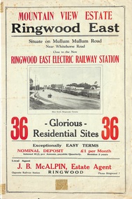
Flyer, Land Sale Brochure, Mountain View Estate, Ringwood East, Vic. - 1923
Bi-fold advertisement for sale of residential allotments, including photographs, map, and summary of subdivision features and local facilities. Undated handwritten notation reads "streets don't exist today".Subdivision layout includes Mullum Mullum Road, Rangeview Avenue, Press Avenue, and Mountview Avenue. Local Agent - J.B. McAlpin, Opposite Railway Station, Ringwood, Phone Ringwood 7. Vendor - T.J. Press, Builder, "Monterey", Second Avenue, Kew, Telephone Haw. 3428. -
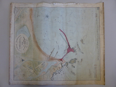 Warrnambool and District Historical Society Inc.
Map, Warrnambool Harbour 1879, 1879
This map shows the plans by eminent harbour engineer, Sir John Coode in 1879. Construction of the breakwater commenced in 1884 and was completed in 1890. Coode first visited Australia in 1872 when he commenced work with the Melbourne Harbour Trust to report on ways to improve Melbourne Port. He is considered one of the most eminent harbour engineers of the 19th century. His original plans for Warrnambool were revised because of cost but then subsequently found to be inadequate and later extended. This was not successful either and the harbour continues to have silting problems to this day. The Warrnambool Breakwater is of historical importance to Victoria and as this map depicts the original plans, it too has great historical significance. It is also significant with its association with Sir John Coode, who was one of the most important port engineers of the 19th century. He worked to improve ports along the Victorian coast including Portland, Geelong, Port Fairy and Lakes Entrance. While this map demonstrates the engineering skills of the era, it also reflects the limitations when natural elements are involved. Its Historical importance also lies in the depiction of items on the map which relate to Warrnambool’s early history. Paper on linen map coloured, and depicting the harbour area of Warrnambool with the proposed breakwater plan in red. It has Victorian Harbours information in oval at top of map. It shows depths of some areas.In oval at top, “Victorian Harbours Warrnambool plan to accompany Sir John Coode report dated 28th Feb 1879. Drawing No 2. Scale 500 feet to 1 inch at bottom centre. Sir John Coode signature in bottom left corner. A 33 A on bottom left reversesir john goode, warrnambool harbour map, warrnambool harbour map 1879, port of warrnambool map 1879 -
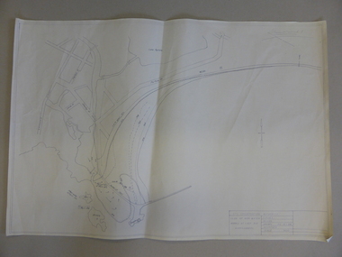 Warrnambool and District Historical Society Inc.
Map, Soil conservation authority:plan of high water marks at Lady Bay Warrnambool, 1984
This map documents the changing state of Lady Bay from around 1870 until 1976. It depicts the changing high water mark over that period and the main outlet of the Merri River in 1872 and 1976.This map provides a useful and significant insight into the ever changing face of Lady Bay from the 1870’s through to 1980’s. Cream paper map drawn with black ink showing Lady Bay and South Warrnambool section of Warrnambool. In lower RH corner Soil conservation AuthorityPlan of High water marks at Lady Bay Warrnambool. Drawn P.D. 19.1/84. Scale 1:3600. Written on back in black pencil: Lady Bay Historical HWM lady bay map, merri river 1872- 1976, merri river 1872- 1976, history of warrnambool -
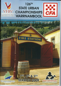 Warrnambool and District Historical Society Inc.
Programme - Booklet, CFA 126 Championship, 2009
The Warrnambool Fire Brigade was formed in 1863. The first fire engine house was in Liebig Street and carters were required to carry water to fire scenes. In 1889 the Council built a new Fire Station on Liebig Street and Warrnambool hosted its own Annual Demonstration in 1894. In 1891 the volunteer brigade became part of the Country Fire Brigade. The Fire Station relocated to Raglan Parade in 1915 and then to Timor Street in 1961. In 1989 the Brigade moved back to Raglan Parade. This booklet is a memento of the State Urban Championships that were held in Warrnambool in 2009 (Volunteer Fire Brigades Victoria and Country Fire Authority)This is a booklet of 96 pages containing printed material, maps, advertisements, photographs and tables. The back cover is white with a Powercor Australia symbol in red and printed material. The front cover is multi-coloured with a photograph of the Fire Station at Flagstaff Hill Maritime Village. The pages are stapled.Front Cover: VFBV, Volunteer Fire Brigades Victoria, CWA, 126th State Urban Championships, 7th, 8th and 9th March 2009, Victorian State Senior Championships, Warrnambool 2009, Warrnambool City Council logowarrnambool fire brigade, state urban championships (2009) -
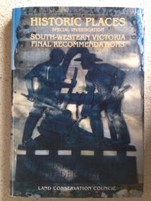 Warrnambool and District Historical Society Inc.
Book, Historic Places of South West Victoria
This is the third in a series of booklets produced by the Land Conservation Council in 1997 (176 pages). Booklets One and Two (1996) contained A Descriptive Report and Proposed Recommendations. The Final Recommendations include information on processes for protection of historic places, lists of significant places in the south-western region and aboriginal historic places. Attached inside the back cover are two maps showing the location of the significant places.This is a useful book as it lists the declared historic sites in the region and researchers will find the information helpful. This is a soft-cover book with a multi-coloured cover featuring a photograph of the Pioneers Memorial, Deep Lead. It has a red-coloured spine and back cover.Front Cover – Historic Places - Special Investigation - South-Western Victoria - Final Recommendations – Land Conservation Council Spine – Historic Places – South-Western Victoria – Final Recommendations – Land Conservation Council Back Cover – Historic Places, Final Rec., code used for retail sales warrnambool -
 Warrnambool and District Historical Society Inc.
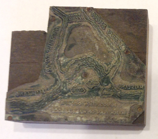
Functional object - Printing block: Warrnambool Historical Society logo, 1980s
This printers block was made for the Warrnambool and District Historical Society and used to print letterheads, envelopes and cards. The impression on the block is of the sketch map drawn by Thomas Price of Port Fairy of the Warrnambool Harbour site when he wrote to Superintendent Charles LaTrobe in 1844 regarding the suitability of the site for a new town. The letter is regarded as an important impetus for La Trobe to consider establishing the town of Warrnambool and so the sketch was used by the Historical Society as its logo on letterheads etc for many years. It was also used as the heading for the Society newsletters from the late 1980s to late 2007.This block of the Thomas Price sketch was used by the Historical Society for many years for its printed material and the sketch was used as its logo for about 20 years so it is an important part of the Society’s history and the block is kept as a reminder of this.This is a printing block with an impression made of metal and attached to a wooden block. The wood is in layers of dark and light coloured wood and has a piece cut out at the top left hand corner. The impression is a representation of the sketch map of Warrnambool Harbour made by Thomas Price in 1844.Sketch map of Warrnambool Harbour 1844warrnambool & district historical society, thomas price sketch -
 Warrnambool and District Historical Society Inc.
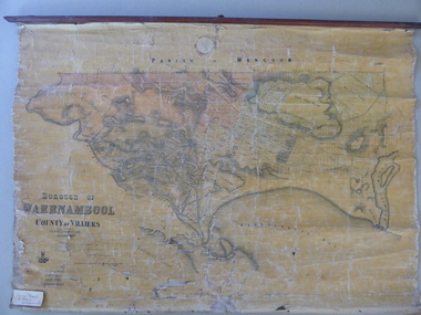
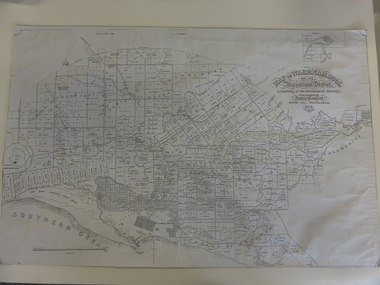
Mao, Borough of Warrnambool, County of Villiers, 1873
This is an early map of the Borough of Warrnambool (1872/3) showing the central town area of Warrnambool and the surrounding district. Reserves, public buildings and some businesses are marked. The map was photolithographed by John Noone, a Melbourne artist and photographer who claimed in 1858 to have the oldest-existing photographic studio in Melbourne. Photolithography was a process first developed in Melbourne. For several years Noone was the official photographer for the Victorian Crown Lands Office and for the Victorian Public Library and Museum. The map has the stamp of the seller of the map – Charles Hider, the well-known stationer and bookseller in Timor Street, Warrnambool. The owner of the map, Henry George Marfell, (1883-1962) was the son of John and Mary Ann Marfell. The Marfells were well-known in Warrnambool as grain merchants and managers of the Warrnambool Co-Operative Milling Company. It is surmised from the writing on the Marfell label that this map was at some stage given by Henry Marfell to the old Warrnambool MuseumThis map of early Warrnambool is of considerable significance, firstly because its original state and early date (1873) make it of antiquarian and historical interest. Also the connection with the names, Charles Hider and Henry Marfell and the old Museum gives it added provenance and interest.This is a wax paper map mounted on cloth. At the top it is attached by nails to a piece of wood and at the top it has a cloth ring for hanging the map. The map is in black shadings on a yellow background. The map is badly creased and coming away from the cloth at the edges and at other various points. There is some red or pink marking or staining on the township area of the map (originally the sold lands on this map were coloured in brown and the reserves, buildings, etc in pink). On the left hand corner there is a piece of paper glued on with some handwriting in ink (Marfell). There is also the stamp of the seller of the map – Charles Hider, stationer and bookseller, of Timor Street Warrnambool‘Early Map of W’bool, H.G. Marfell’ history of warrnambool, charles hider, henry marfell -
 Warrnambool and District Historical Society Inc.
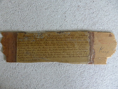
Frame Fragment, Frame Fragment from 1860 J Wilder, Late 19th century
Joseph Wilder, a professional photographer, came to Warrnambool in 1860 and took a series of photographs, two of which survive today. One was of the local Volunteer Corps and the other was a series of photographs taken from Cannon Hill showing Merri Street and the town and buildings beyond. It seems that copies of these last-mentioned photographs were framed to produce a large panoramic view of 1860 Warrnambool and one of these was given to the old Warrnambool Museum in the 1880s by James Astley Bromfield. He had established a chemist’s shop in Warrnambool in 1854 and showed his interest in the history of the young town by producing a map in 1856 showing the first landowners, a seminal resource today for historians. He again demonstrated this interest when he included the names of the people and places in the 1860 photograph he gave to the museum in the 1880s. The frame fragment was found amongst the collection of items from the old Museum at Flagstaff Hill Maritime Museum and brought to the Historical Society to accompany the original series of photographs. Bromfield went to live in Melbourne in the 1880s. It is presumed that the plastic cover has been placed on the frame fragment at a much later date than the 1880s.This frame fragment is interesting and very important for several reasons:- 1. It is one demonstration of the interest that James Astley Bromfield had in local history 2. It came from the old Warrnambool Museum and shows how that institution kept items of historical interest 3. It gives us the names of the people and places in the Joseph Wilder photographs of 1860 that placed together form a panorama that reveals what a major section of Warrnambool looked like only 13 years after its foundation. The list enables us to correctly identify the early places and people and so is invaluable for research purposes 4. It links a Museum exhibit of the 1880s with the original 1860 photographs which are held by the Historical Society This is a piece of wood broken from a frame containing a photograph. It has jagged edges. It contains the list of people and places depicted in the Joseph Wilder panorama photograph of Warrnambool in 1860. The list is handwritten in ink on paper which has been attached to the frame with a piece of plastic. Warrnambool in 1860 Photographed by Wilder. Showing children of the late Andrew Semple etc In red pencil – ‘Keep’, in ink, ‘Keep’ On separate piece of paper - Presented to Warrnambool Mechanics’ Muzeum by James Astley Bromfield, August 3rd 1886 joseph wilder 1860, panorama of warrnambool -
 Warrnambool and District Historical Society Inc.
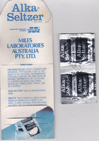
Mixed media - Travellers Aid Bag, Travellers Aid bag & Contents, C 1980
These items were given to clients of the Mid City Motel (probably the one in Ballarat ). The Mid City Motel company was formed in 1963 by a syndicate with the motel in Raglan Parade, Warrnambool. It was later sold with the company liquidated in 1982. The expansion from Warrnambool to Ballarat occurred in 1970 with a building in Doveton Street North, Ballarat. Items such as the sewing kit and shower cap are still given out as promotional material in many motels today. These items are of little importance but are examples of the promotional activities of the motel/tourism scene 30 or so years ago. They may be useful for display.This is a small plastic bag containing a paper sewing kit and a paper folder containing two Alka-Seltser tablets. The sewing kit is red and white and the Alka Seltzer packet is mostly blue. The three items come from the Mid-City Motel and are intended to be kept in a car. Plastic Bag: Mid City Motels, Princes Highway, Warrnambool, 055 62 8026, Doveton Street, Ballarat, 053 31 1222, Travellers Aid Bag for your car with Sewing Kit, Alka Seltzer, Shoe Shine, Shower Cap, Have a Nice Day, Ballarat City Map.warrnambool, mid city motel, tourism -
 Warrnambool and District Historical Society Inc.
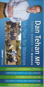
Document, Leaflet Federal Election, 2013
This is a 2013 election leaflet for Dan Tehan, the Federal Member for Wannon (Liberal Party). Wannon electorate is in the south west of Victoria and was one of the original seats established in 1900 for the first Federal Government. Warrnambool is in the Wannon Electorate. Dan Tehan won the seat in 2010 for the Liberal Party and has held it ever since. This is a leaflet of four pages and a cover. The printed material is multi-coloured with colour photographs, a map of the electorate and election statements and promises. There is one loose sheet printed in black and white. dan tehan, wannon electorate, warrnambool -
 Warrnambool and District Historical Society Inc.
Map, Warrnambool 1859, Late 20th century (copy)
This is a copy of Bromfield’s 1856 map of Warrnambool and district. James Astley Bromfield was a pioneer settler in Warrnambool. He established a chemist’s shop in 1854, initially situated in Timor Street. He moved his shop to Liebig Street with a new building erected in 1875. Bromfield was a prominent resident of Warrnambool (Shire Councillor, Fire Brigade member, Cricket Club member, associated with horse racing etc). He was interested in preserving the history of Warrnambool and this map he produced in 1856 was an example of this interest.This is a copy only but this 1856 map is of prime importance as it contains the names of the original landowners of land in north Warrnambool and the surrounding district. It is a frequently-used resource by historians.This is a copy of a map of Warrnambool and its agricultural district published by James Astley Bromfield in 1856. The map is mounted on cardboard and has black printing on a white background. ‘Map of Warrnambool and its Agricultural District according to the Government Survey’s published by Astley Bromfield, Medical Hall, Warrnambool 1856, James Ferguson, Lithr., Melbne.’bromfield’s 1856, map, warrnambool and district