Showing 11924 items
matching victoria road
-
 Tarnagulla History Archive
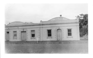
Photograph of former Victoria Hotel and Theatre, Tarnagulla, Former Victoria Hotel and Theatre, Tarnagulla, Late 1960s
... as the town's public hall. tarnagulla commercial road victoria hotel ...Murray Comrie Collection. Building is still on Commercial Road and in 2019 is used as the town's public hall.Monochrome photograph depicting former Victoria Hotel and Theatre, which is located in Commercial Road, Tarnagulla.tarnagulla, commercial road, victoria hotel and theatre, buildings, houses -
 Tarnagulla History Archive
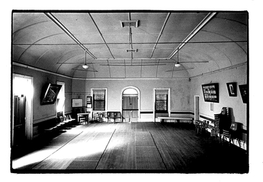
Photograph of the interior of the Victoria Theatre, Tarnagulla, Interior of the Victoria Theatre, Tarnagulla, c. 1960s
... Commercial Road, Tarnagulla, Victoria, Australia.... tarnagulla commercial road victoria theatre tarnagulla public hall ...Murray Comrie Collection. A monochrome photograph depicting the interior of the Victoria Theatre, Tarnagullatarnagulla, commercial road, victoria theatre, tarnagulla public hall -
 Flagstaff Hill Maritime Museum and Village
Instrument - Fob watch, 1814
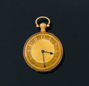
... walker robert townshend loch ard gorge great ocean road victoria ...Watchmaker History: James McCabe was born in 1748. He was the son of Patrick McCabe, a notable watchmaker from Lurgan in County Armagh, Ireland. James McCabe immigrated to London in 1775 and established his business in Bells Building, Fleet Street, on 2nd April 1781. He was made an Honorary Freeman of the Clockmakers Company. The House of McCabe was renowned for the sheer variety of its designs, and the creativity and prestige of its manufacture were celebrated and revered by owners worldwide. These pieces remain highly collectable today and fetch increasingly higher prices at auction houses worldwide. Watch association with the Loch Ard: The watch was saved from the sea when discovered on the body of Mrs Rebecca Carmichael from Dublin and handed to Eva Carmichael, the only family member to survive the fatal wreck of the Loch Ard on 1st June 1878. Eva gifted the watch to her husband, Thomas Achilles Townsend when they married in 1884; his name is engraved on the rear movement cover. The watch was held by the family until 2011 when they decided to bring the watch, to Australia for auction. At this time the watch was in the possession of Eva Carmichael's grandson, Robert Townsend. Given its connection with the Loch Ard shipwreck, it was purchased at auction by Flagstaff Hill Maritime Village on 25th October 2011 to add to its Loch Ard collection and is currently referred to as the Carmichael watch. It is now on display alongside the Minton Peacock, which also survived the Loch Ard shipwreck, and other artefacts from the collection. James McCabe was originally a Belfast watchmaker who had moved his business to London. At the time James McCabe was much esteemed for producing fine watches and clocks, especially for export to India. Only the best watches were inscribed “James McCabe” and many with highly decorated cases were intended for the Indian market. Contemporary newspaper accounts of the watch's discovery echoed a Carmichael family tradition that the watch had been intended as a gift from the City of Dublin to King George IV to mark his planned visit to the city in 1821, however, there is no evidence to support this theory. Dr Evory Carmichael, according to some accounts, bought this watch from a nobleman for about £100 at some point and so it travelled with him on his final fateful journey to Australia. Today we can only guess at the actions of Mrs Carmichael in the chaos and darkness of the pre-dawn shipwreck. Perhaps the two items that were found on her body, the watch and a locket, were items that reminded her of those she held most dear, her husband and her family. When Mrs Carmichael's body was washed ashore the watch was found secreted in the waistband of her dress. In its own right the watch is of artistic and monetary value and is a rare and beautiful object depicting watch making in the early 19th century. It is a historically significant object in it’s own right and there is additional importance, surviving a significant event in the maritime history of Victoria. The wreck of the Loch Ard, Victoria's greatest maritime disaster has also been declared an event of National Significance because of its strong connection to Australia's immigration and maritime history. The watch, together with the Loch Ard Peacock, make up the two most significant shipwreck artefacts in Australia. Both of these items are of great social significance to not only local people but the wider Australian community. Funding for the watches purchase came from six local trusts and one anonymous citizen and is now on permanent display. Both these artefacts symbolise and helps to interpret the stories of survival along the Shipwreck Coast. Fob Watch, known as the "Carmichael Watch" or the "Loch Ard Watch". 1814 fob pocket watch belonging to the Carmichael family, recovered from the wreck of the Loch Ard. Fob watch (or pocket watch)and winding key, made by James McCabe and Son, of Cornhill, London. The watch is in excellent condition and its design is decorative and intricate. The gold face is covered by glass. The gold rear cover is hinged over a silver inner cover that includes the winding hole. The watch has a knob with a swinging ring from which it can be hung. The dial of the gold watch face is textured and has raised Arabic numerals and every minute is marked around the perimeter by a dot, with the 5-minute dots slightly larger. The numerals and dots are a different coloured gold than the rest of the face. The centre of the face has a wavy pattern fanning out to the base of the numerals. The hour and minute hands are of a dark colour. The stems of the hands are a wavy shape and finish with spade shaped tips; the tip of the hour hand is larger than that of the minute hand. The hour hand reaches to the base of the numerals and the minute hand is long enough to rest between the minute dots. The back of the watch is decorated with a detailed design on a textured gold background. The design is embossed in coloured metals; gold, silver, greenish-gold and pink. In the centre is a dove resting on leaves of a pot plant that sits on a silver circular base. Another dove is flying above it, and their beaks touch together. On the right of the base of the pot plant is a dog resting on its hind legs, body facing away from the plant and head twisted around to look at the birds. On the sides of this design and meeting at the base are sprigs of leaves and buds. Around this central design is a rope-like border. Around the perimeter of the case is a border of leaves and budding stems. The inside of this cover has embossed hallmarks, numbers and etched markings indicating that the watch is 18 carat gold, made by James McCabe, assayed in London in 1814 and the case may have been made by Daniel Willmott, case maker. The silver inner workings cover has a full name beautifully engraved on it. There is a winding hole that accesses a square-ended lever for the key to fit over. The handle of the watch is a twisted gold knob with a hollow ‘D’-shaped swinging ring attached to the end of it. This knob also has a hallmark.On the silver inner workings cover “Thomas Achilles Townshend” is engraved, underscored by a thin, delicately decorated line. On the gold handle is the logo of a crown with “18”’ next to it. Inside the gold rear case is stamped “DW’. Under that is etched “JAN 77 II”. Underneath this are 3 logos; a logo “leopard, crowned”’, a logo “ crown on top of 18”, and a logo “T”. Under these 3 symbols is part of a stamp that could possibly be “IMC”. Under this is “ ’ 5 9 4 ”. Other numbers, symbols and letters are etched into this case including “15001”, “2/5/19”. Others are difficult to read.warrnambool, shipwrecked coast, shipwreck coast, flagstaff hill, flagstaff hill maritime museum, flagstaff hill maritime village, maritime museum, shipwrecked artefact, shipwreck artefact, carmichael, townshend, townsend, carmichael watch, loch ard watch, pocket watch, loch ard, 1st june 1878, james mccabe, thomas walker, robert townshend, loch ard gorge, great ocean road, victoria., memorial headstone -
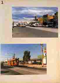
![Newspaper - Newspaper Clipping - Digital Image, Preston Post-Times, Tramway gets go-ahead [c1987], 1987c](/media/collectors/4f729f5697f83e03086015b8/items/6744fdc20d508cb167f8fed4/item-media/6744fdf10d508cb167f9044b/item-fit-380x285.jpg) Greensborough Historical Society
Greensborough Historical SocietyNewspaper - Newspaper Clipping - Digital Image, Preston Post-Times, Tramway gets go-ahead [c1987], 1987c
... Road Bundoora c1987 public transport victoria trams plenty road ...The Plenty Road tram service is being extended to McLeans Road Bundoora c1987Digital copy of newspaper articlepublic transport victoria, trams, plenty road bundoora, mcleans road bundoora -
 Melbourne Tram Museum
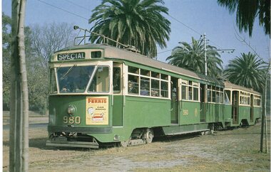
Photograph - Illustration/s, Topmill, 1996
... Trams tramways Dandenong Road Victoria Parade Calendar tram 980 ...Set of two illustrations from the 1996 Topmill Calendar of tram 980, backed onto another sheet of lightweight card or another photograph. See Reg Item 246. .1 - PCC 980 and Y1 611 - by Dr D. Ellerton, 24-4-1962 in Dandenong Rd. .2 - PCC 980, in Victoria Parade, same date and photographer.in ink on rear "MMTB #980"trams, tramways, dandenong road, victoria parade, calendar, tram 980, pcc class -
 Melbourne Tram Museum
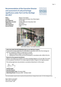
Document - Report, Heritage Victoria, "Recommendation of the Executive Director and assessment of cultural heritage significance - Malvern Tram Depot - Amendment - 20/2/2020", Jan. 2020
... Heritage Victoria Significance Coldblo Road Transformer Power ...Digital copy of a 60 page report - ""Recommendation of the Executive Director and assessment of cultural heritage significance - Malvern Tram Depot - Amendment - 20/2/2020" Details the history and context of the location relevant to the development of the PMTT and MMTB systems route, the equipment contained within the building, includes all moveable objects within the building including documents. Has a detailed statement of cultural significance, proposed permit policy. The history includes details of the electrification of the Melbourne's tramways, the rotary converter equipment, its operation, architecture. Report includes photographs of the interior of the building. The last amendment was to include the items with the former Rotary Converter sub-station.trams, tramways, substation, malvern depot, rotary converters, heritage victoria, significance, coldblo road, transformer, power supply, electrical engineering, pmtt, mmtb -
 Melbourne Tram Museum
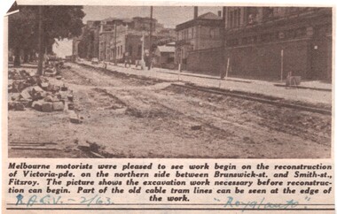
Newspaper, Royal Automobile club of Victoria (RACv), removal of the cable tram track in Victoria Parade, 1963 to 1971
... Road Victoria Parade Cable Trams W2 class SW6 class Burke Road ...Set of 8 newspaper clippings, mid 1960's concerning traffic control and congestion issues. .1 - Royal auto - 2/1963 - reporting on the removal of the cable tram track in Victoria Parade between Brunswick and Smith St, noting the old cable tram lines. .2 - Royal auto - 1/65 - Photo of Toorak Road Toorak with a tram and parked cars. .3 - Royal auto - 8/64 on Chapel St with W2 324 (route 77, City) showing the impact of parked cars at 8.45am and a motor car trying to squeeze past. .4 - Royal auto - 9/64, Burke Road Camberwell, showing the impact of parked cars and trams. Photo includes SW6 934 (Route 7 Camberwell) .5 - Royal auto - 8/67 - Swanston St near Collins St. .6 - View of Toorak Road, Hartwell, W2 641 (Spencer St, route 74) photo 8/68 by John Shingler. shows the shopping centre. .7 - Royal auto - 9/64 - Johnston St Collingwood and buses. .8 - MMBW Living City Winter 1971 of Kew Junction, peak hour inbound noting the new Eastern Freeway will reduce congestion.Extensive notes on the rear of the photo, see image i2trams, tramways, congestion, traffic control, racv, chapel st, toorak road, victoria parade, cable trams, w2 class, sw6 class, burke road, camberwell, route 77, route 7, swanston st, kew junction, route 74, hartwell, johnston st, buses, tram 324, tram 641, tram 934 -
 Melbourne Tram Museum
Document - Report, "Malvern Tram Depot - Heritage Listing Information", May. 2014
... Heritage Victoria Significance Coldblo Road Transformer Power ...Report - seven A4 sheets, stapled in the top left hand corner, titled "Malvern Tram Depot - Heritage Listing Information" detailing an updated history of the Malvern Tram depot (5/2014), additional objects - mainly substation equipment. Has updated permit conditions pending approval by the Heritage Council. See also Reg Item 550 and 5318 for associated documents.trams, tramways, substation, malvern depot, rotary converters, heritage victoria, significance, coldblo road, transformer, power supply, electrical engineering, pmtt, mmtb -
 Melbourne Tram Museum
Document - Report, Melbourne & Metropolitan Tramways Board (MMTB), "Intersection Improvement designs", 1973-1974
... Road Elizabeth St Victoria St Junction Road Works Traffic ...Report - Foolscap about red comb binder with card covers, 5 pages + 3 fold out plans - titled "Intersection Improvement designs" dated 1973 - 1974. Provides designs for intersections in Flemington Road and Elizabeth St to improve flow of trams, pedestrian safety and traffic flow. Drawing P14640 - Victoria and Elizabeth Sts P14684 - Flemington Road, Royal Parade and Elizabeth St (Haymarket Roundabout) P14600 - Royal Park Junction - Abbotsford St - Flemington RoadIn top right hand corner "D W Lees" in ink.trams, tramways, trackwork, royal park, abbotsford st, flemington road, elizabeth st, victoria st, junction, road works, traffic control, haymarket -
 Melbourne Tram Museum
Album - Series of 40 colour prints, Brendon Carter, 1986
... St Gisborne Victoria St Domain Road St Georges Road Gilbert ...Set of fourty colour prints by Brendon Carter 1 - W2 444, Elgin St Carlton - Transporting Art - 15-10-1986 2 - W2 607. Grantham St West Brunswick - 17-10-1986 3 - W2 453 and W6 976 - Swanston St - 17-10-1986 4 - W2 453 ditto 5 - ditto, turning into Victoria St 6 - SW5 619 and W2 453 - Victoria and Swanston Sts 7 - W2 471 Swanston St 8 - W2 478 Swanston St 9 - W2 478 Swanston St 10 - W2 431 in Collins at Swanston St 11 - ditto 12 - W7s 1033, 1030, W2 243 and W6 972 Gisborne and Victoria Streets 13 - W2 436 - ditto 14 - SW2 432 and SW5 782 St Kilda Road 15 - W2 605 ditto 16 - W2 629 La Trobe St 17 - W2 629 and 644 La Trobe St 18 - W2 647 La Trobe St 19 - W2 547 Swanston St 20 - W2 441 - William and La Trobe Sts 21 - W2 1275 - corner of Park St and Domain Road 22 - W2 478 and SW5 730 - Swanston St at Flinders St. 23 - SW5 730 and W2 644 - ditto - 31-10-1986 24 - W2 547 at Flinders St Station - 31-10-1986 25 - W2 456 Swanston St - 14-11-1986 26 - W2 456 Domain & Park - 14-11-1986 27 - W2 456 ditto 28 - W2 458 and SW5 783 - William St - 14-11-1986 29 - W2 650 - West Preston terminus - 21-11-1986 30 - ditto - Gilbert Road 31 - ditto 32 - W2 431 - St Georges Road 33 - W2 431 - Miller St by Preston workshops 34 - ditto 35 - Miller St - the hump 36 - W2 646 at Preston Depot 37 - W2 646 at Dundas St at the start of the hump 38 - ditto on top with bridge works underway. 39 - W2 426 Hawthorn Bridge 40 - SW2 478 and SW5 833 - Camberwell terminus.Yields information about Melbourne Trams in 1986 when many W2s were still running.Album - 10 heavy card sheets with plastic sheets over each, white plastic ring bound, covered with a large photograph of Alf Twentyman's cable cars at Northcote. (see item 3086 for original unused version), with 40 colour prints, two per page and a listing or index of each print.Each print separately listed.swanston st, elgin st, grantham st, collins st, st kilda road, latrobe st, william st, gisborne, victoria st, domain road, st georges road, gilbert road, west preston, miller st, dundas st, hawthorn bridge, camberwell, w2 class, tram 444, tram 607, tram 453, tram 976, tram 619, tram 471, tram 478, tram 431, tram 1033, tram 1030, tram 243, tram 972, tram 436, tram 432, tram 782, tram 605, tram 629, tram 644, tram 647, tram 547, tram 441, tram 1275, tram 730, tram 456, tram 783, tram 650, tram 646, tram 426, tram 833 -
 Bendigo Historical Society Inc.
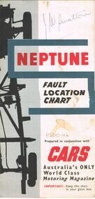
Map - J W SWATTON COLLECTION: MAPS
... , Victoria, Road Condition Map of Victoria including Melbourne-Cairns... of the City of Ballarat, Victoria, Road Condition Map of Victoria ...Seven maps of various sizes. Map of the City of Ballarat, Victoria, Road Condition Map of Victoria including Melbourne-Cairns & Melbourne-Adelaide, Neptune Fault Location Chart, Grampians District Map, Racv Tour Planning Map Showing Road Conditions for Victoria, NSW and Queensland and Mt Macedon & District. Two of the maps have J W swatton & J Swatton written on them.j w swatton collection, racv, mobil, neptune, a r blair, j ewins & sons pty ltd, berry anderson & co -
 Bendigo Historical Society Inc.
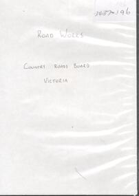
Photograph - ROAD WORKS
... DVD. Road works. Country Roads Board. Victoria....DVD. Road works. Country Roads Board. Victoria. Photograph ...DVD. Road works. Country Roads Board. Victoria. -
 Glen Eira Historical Society
Album - Album page, Kambrook Road, Circa 1972
... 26 Kambrook Road , Caulfield North, Melbourne, Victoria ...This page of photographs is part of the Caulfield Historical Album 1972. This album was created in approximately 1972 as part of a project by the Caulfield Historical Society to assist in identifying buildings worthy of preservation. The album is related to a Survey the Caulfield Historical Society developed in collaboration with the National Trust of Australia (Victoria) and Caulfield City Council to identify historic buildings within the City of Caulfield that warranted the protection of a National Trust Classification. Principal photographer thought to be Trevor Hart, member of Caulfield Historical Society. Most photographs were taken between 1966-1972 with a small number of photographs being older and from unknown sources. All photographs are black and white except where stated, with 386 photographs over 198 pages. First 2 images: milkbar and residence corner Kambrook and Balaclava Roads ie south west corner - building named Airdrie 3rd image: https://vhd.heritagecouncil.vic.gov.au/places/43737 - re 26 Kambrook Road and 345 Balaclava Road corner building ie south east corner: A prominently situated two-storeyed complex of late Victorian buildings consisting of "Wybar's Buildings" occupying the Balaclava Road/ Kambrook Road corner and the "Caulfield Bakery" facing Kambrook Road, separated by a driveway from a single storeyed shop. The main building has a comer splay and balustraded parapet with curved pediments, the words "Wybar's Buildings 1887" having been obliterated but "Caulfield Bakery 1887" with the characteristic wheatsheaf surviving in raised cement work. The walls are stuccoed and richly ornamented with bracketed cornices and keystones with masks extending to the Bakery. The main building is further distinguished by the Masonic symbol of the mason's dividers in the pediment whilst the upper level of the bakery is in overpainted brickwork. The single storeyed shop incorporates the bracketed cornice and consoles characteristic of the main buildings and is in other respects a utilitarian structure. 4th image: https://vhd.heritagecouncil.vic.gov.au/places/42415 (on 24/01/2021) - 196 Kambrook Road An imposing late Victorian poly-chrome brick asymmetrical villa with corner verandah and projecting west facing wing with faceted window bay to the facade. Body bricks are red and relieved by cream and black brick banding and by cream bricks to the bracketed eaves. The fretted barge with king post treatment and timber posted verandah are unique in the Municipality and unusual in the metropolitan area and demonstrate an understated appreciation of the emerging Queen Anne mode.345 Balaclava and 26 Kambrook Roads HO91 - City of Glen Eira https://vhd.heritagecouncil.vic.gov.au/places/43737 (on 24/01/2021) "Wybar's Buildings" at the corner of Balaclava Road and Kambrook Road are important as a prominent late Victorian commercial development incorporating a variety of activities including a bakery and possibly a coffee palace, the latter understood to be unique within the municipality, but characteristic of the period. It is a rare complex of its type in Caulfield and is important also as evocative evidence of the late Victorian Land Boom and the creation of a small now defunct commercial centre at this location by the George Wybrow. 196 Kambrook Road HO122 - City of Glen Eira https://vhd.heritagecouncil.vic.gov.au/places/42415 "Glencoe" is situated at no. 196 Kambrook Road, Caulfield North and was built for the boot manufacturer, Robert Bruce Mair, in 1888. It is of historic and aesthetic significance. It is historically significant (Criterion A) as the home of an inner suburban industrialist, notable a boot manufacturer, demonstrating the attraction of Caulfield as a residential location for the manufacturers of the metropolis during the late Victorian Boom period. It is aesthetically significant (Criterion E) as a very early example of a Queen Anne influenced late Victorian villa, comparing at the State level with ''Woodlands'' (1888), North Essendon, generally acknowledged to be one of Australia's earliest houses to fully exploit this emerging style. The ornamental timberwork is especially expressive of the new architectural fashion and compares with the house at 33 Clarence Street, Elsternwick (1888-89).Page 105 of Photograph Album with two photographs of a milk bar and attached residence, one older photograph of Wybar's Building and another photograph of a house on Kambrook Road (all are landscape).Handwritten: 196 KAMBROOK ROAD / 1970 - GAFFNEY MRS S.M. [under bottom right photo] / 100 [bottom left]trevor hart, kambrook road, victorian style, caulfield north, parapets, wybar's buildings 1887, caulfield bakery 1887, architectural features, painted bricks, balaclava road, george wybrow, shops, milk bars, airdrie, polychrome bricks, verandahs, queen anne architectural style, houses, glencoe, robert mair -
 Flagstaff Hill Maritime Museum and Village
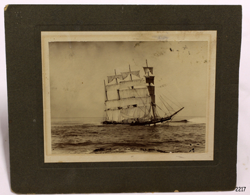
Photograph - Vessel, Sailing Ship, Foyle Photographic Studio, 1908
... Peterborough, Great Ocean Road, Victoria, Australia ...The photograph is of the sailing ship Falls of Halladale. The ship is in shallow water at Peterborough where it sank on November 14th 1908. The inscription on the photograph reads "Nov 4th 1908". The iron-hulled, four-masted barque, the Falls of Halladale, was a bulk carrier of general cargo. She left New York in August 1908 on her way to Melbourne and Sydney. In her hold, along with 56,763 tiles of unusual beautiful green American slates (roofing tiles), 5,673 coils of barbed wire, 600 stoves, 500 sewing machines, 6500 gallons of oil, 14400 gallons of benzene, and many other manufactured items, were 117 cases of crockery and glassware. Three months later and close to her destination, a navigational error caused the Falls of Halladale to be wrecked on a reef off the Peterborough headland at 3 am on the morning of the 15th of November, 1908. The captain and 29 crew members all survived, but her valuable cargo was largely lost, despite two salvage attempts in 1908-09 and 1910. ABOUT THE ‘FALLS OF HALLADALE’ (1886 - 1908) Built: in1886 by Russell & Co., Greenock shipyards, River Clyde, Scotland, UK. The company was founded in 1870 (or 1873) as a partnership between Joseph Russell (1834-1917), Anderson Rodger and William Todd Lithgow. During the period 1882-92 Russell & Co., standardised designs, which sped up their building process so much that they were able to build 271 ships over that time. In 1886 they introduced a 3000 ton class of sailing vessel with auxiliary engines and brace halyard winches. In 1890 they broke the world output record. Owner: Falls Line, Wright, Breakenridge & Co, 111 Union Street, Glasgow, Scotland. Configuration: Four masted sailing ship; iron-hulled barque; iron masts, wire rigging, fore & aft lifting bridges. Size: Length 83.87m x Breadth 12.6m x Depth 7.23m, Gross tonnage 2085 ton Wrecked: the night of 14th November 1908, Curdies Inlet, Peterborough south west Victoria Crew: 29 The Falls of Halladale was a four-masted sailing ship built-in 1886 in Glasgow, Scotland, for the long-distance cargo trade and was mostly used for Pacific grain trade. She was owned by Wright, Breakenridge & Co of Glasgow and was one of several Falls Line ships, all of which were named after waterfalls in Scotland. The lines flag was of red, blue and white vertical stripes. The Falls of Halladale had a sturdy construction built to carry maximum cargo and able to maintain full sail in heavy gales, one of the last of the ‘windjammers’ that sailed the Trade Route. She and her sister ship, the Falls of Garry, were the first ships in the world to include fore and aft lifting bridges. Previous to this, heavily loaded vessels could have heavy seas break along the full length of the deck, causing serious injury or even death to those on deck. The new, raised catwalk-type decking allowed the crew to move above the deck stormy conditions. This idea is still used today on the most modern tankers and cargo vessels and has proved to be an important step forward in the safety of men at sea. On 4th August 1908, with new sails, 29 crew, and 2800 tons of cargo, the Falls of Halladale left New York, bound for Melbourne and Sydney via the Cape of Good Hope. The cargo on board was valued at £35,000 and included 56,763 tiles of American slate roofing tiles (roof slates), 5,673 coils of barbed wire, 600 stoves, 500 sewing machines, 6,500 gallons of oil, 14,400 gallons of benzene, plumbing iron, 117 cases of crockery and glassware and many other manufactured items. The Falls of Halladale had been at sail for 102 days when, at 3 am on the night of 14th November 1908, under full sail in calm seas with a six knots breeze behind and misleading fog along the coast, the great vessel rose upon an ocean swell and settled on top of a submerged reef near Peterborough on the south-west Victoria’s coast. The ship was jammed on the rocks and began filling with water. The crew launched the two lifeboats and all 29 crew landed safely on the beach over 4 miles away at the Bay of Islands. The postmistress at Peterborough, who kept a watch for vessels in distress, saw the stranding and sent out an alert to the local people. A rescue party went to the aid of the sailors and the Port Campbell rocket crew was dispatched, but the crew had all managed to reach shore safely by the time help arrived. The ship stayed in full sail on the rocky shelf for nearly two months, attracting hundreds of sightseers who watched her slowly disintegrate until the pounding seas and dynamiting by salvagers finally broke her back, and her remains disappeared back into deeper water. The valuable cargo was largely lost, despite two salvage attempts in 1908-09 and 1910. Further salvage operations were made from 1974-1986, during which time 22,000 slate tiles were recovered with the help of 14 oil drums to float them, plus personal artefacts, ship fittings, reams of paper and other items. The Court of Marine Inquiry in Melbourne ruled that the foundering of the ship was entirely due to Captain David Wood Thomson’s navigational error, not too technical failure of the Clyde-built ship. The shipwreck is a popular site for divers, about 300m offshore and in 3 – 15m of water. Some of the original cargo can be seen at the site, including pieces of roof slate and coils of barbed wire. The photograph shows the ship Falls of Halladale in full sail, demonstrating the sails used for power at sea.A sepia landscape photograph; image of a sailing ship in shallow water in full sail. The vessel is the"Falls of Halladale" aground off Peterborough 1908. A figure is in the foreground. Photographed in 1908 by Foyle of Warrnambool. A pencil inscription on the back is underlined. A white sticker is attached.In pencil on reverse "The Falls of Halladale / Wrecked at Peterborough / Nov 4th 1908" [Note: the ship was wrecked on Nov 14th 1908] On white sticker "131"flagstaff hill, flagstaff hill maritime museum and village, warrnambool, maritime museum, maritime village, great ocean road, shipwreck coast, photograph, falls of halladale, sailing ship, vessel, shipwreck, foyle -
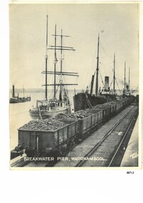 Flagstaff Hill Maritime Museum and Village
Photograph - Vessels at Breakwater Pier, Warrnambool, Foyle Photographic Studio, circa 1906
... Liebig Street, Warrnambool, Great Ocean Road, Victoria ...This photograph was one of ten photographs donated to Flagstaff Hill Maritime Museum and Village by Fred Trewartha. Frederick John Fox Trewartha (Fred) was a well-known Warrnambool businessman. He was born in Beeac near Geelong in 1920 and came to Warrnambool with his family as a very young child. He was apprenticed to his father John, as a saddler and later opened his own shop on Raglan Parade. He then moved into working with tarpaulins and canvases for the trucking industry. Fred was keenly interested in photography (and was a member of the Warrnambool Cine Club), yachting and boat building. He kept his yacht moored at Port Fairy for many years and participated in sailing events locally and interstate. He also built boats with his sons. He had the opportunity to meet many older sailors and it's thought this photo (and others in the set) may have been given to him by one of these men. Fred Trewartha died in 2016 in Warrnambool. The three identifiable ships in this picture are the "Speculant", the "S. S. Barrabool" and the "S. S. Flinders" - coastal trading vessels that regularly came and went from Warrnambool. The steamer on the left hasn't been identified. The barquentine SPECULANT was a steel, three-masted sailing ship built in 1895 in Inverkeithing, Scotland, registered in Warrnambool, Victoria and wrecked at Cape Paton, Victoria, 10th February 1911. The SPECULANT had been involved in the timber trade between the United Kingdom and Russia, until sold to its Warrnambool owners and timber merchants Messrs. P.J. McGennan & Co. (Peter John McGennan) in 1902 for 3000 pounds and had her sailed to Warrnambool as her new port. Peter John McGennan was born in 1844 and worked as a builder and cooper in Holyhead, Anglesea, Wales. He immigrated to Australia in 1869 as a free settler and arrived in Warrnambool in 1871 and undertook management of a property in Grassmere for Mr. Palmer. Peter met his wife Emily in South Melbourne and they married in 1873. They had ten children including Harry who lived to 1965, and Andrew who lived until 1958. (The other children were their four brothers - John who was killed in the Dardenalles aged 35, Frederick who died aged 8, Peter who died aged 28, Frank who died aged 5 weeks - and four sisters - Beatrice who died age 89, Edith who died aged 49, Blanche who died aged 89 and Eveline who died aged 48.) In 1874 Peter starting a boating establishment on the Hopkins River. In 1875 he opened up a Coopers business in Kepler Street next to what was Bateman, Smith and Co., moving to Liebig Street, next to the Victoria Hotel, in 1877. In 1882 he then moved to Lava Street (which in later years was the site of Chandlers Hardware Store). He was associated with the establishment of the Butter Factory at Allansford. He started making Butter Boxes to his own design and cheese batts for the Butter Factory. In 1896 established a Box Factory in Davis Street Merrivale, employing 24 people at its peak, (it was burnt down in 1923); and in Pertobe Road from 1912 (now the Army Barracks building). Peter was a Borough Councillor for Albert Ward from 1885 to 1891, he commenced the Foreshore Trust (including the camping grounds along Pertobe Road), and he was an inaugural Director of the Woollen Mill in Harris Street, buying an extensive share-holding in 1908 from the share trader Edward Vidler. They lobbied the Town Hall to have a formal ‘Cutting’ for the waters of the Merri River to be redirected from its natural opening south of Dennington, to its existing opening near Viaduct Road, in order to have the scourings from the wool at the Woollen Mill discharged into the sea. He sold Butter Boxes around the state, and had to ship them to Melbourne by rail. Peter’s purchase of the SPECULANT in 1902 enabled him to back-load white pine from Kaipara, New Zealand to Warrnambool to make his butter boxes then, to gain profitability, buy and ship potatoes and other primary produce bound to Melbourne. (McGennan & Co. had also owned the LA BELLA, which had traded in timber as well, until she was tragically wrecked with the loss of seven lives, after missing the entrance channel to Warrnambool harbour in 1905. It appears that the SPECULANT was bought to replace the LA BELLA.) In 1911 the SPECULANT had been attempting to depart Warrnambool for almost the entire month of January to undergo docking and overhaul in Melbourne. A month of east and south-easterly winds had forced her to remain sheltered in Lady Bay, Warrnambool apart from one morning of northerlies, when an attempt was made to round Cape Otway; she had to return to shelter in Portland after failing to make any headway. With only 140 tons of sand ballast aboard, the ship would not have been easy to handle. Captain Jacobsen and his crew of nine, mainly Swedes, decided to make for Melbourne, leaving Portland Harbour on 5th February 1911. By the 9th they had reached Cape Otway, where they encountered a moonless night, constant heavy rain, and a heavy sea with a south-easterly wind blowing. After safely rounding Cape Otway the course was changed to east, then north-east to take the vessel to a point six miles off Cape Patton, following the orders of Captain Jacobsen, who told the crew to be very careful with the steering, as the wind and sea was running to leeward. The patent log (used to measure speed) had been out of order for the last four months as no-one in Warrnambool was able to fix it: it was intended to have it repaired in Melbourne. In the meantime the crew measured the vessel's speed by looking over the side and estimating wind strength. This compounded the difficulties of imprecise positioning, as the strong cross wind and sea were acting on the lightly laden vessel to steadily drive it towards the shore. At 3.30am on Friday 10 February 1911 Captain Jacobsen and the first mate were looking over the side of the vessel when they heard the sound of breakers and suddenly struck the rocks. The crew immediately knew they had no chance of getting the SPECULANT off, and attempted to rescue themselves by launching the lifeboat, which was instantly smashed to pieces. One of the crew then volunteered to take a line ashore, and the rest of the crew were all able to drag themselves to shore, some suffering hand lacerations from the rocks. Once ashore they began to walk along the coast towards Lorne, believing it was the nearest settlement. Realising their mistake as dawn broke they returned westwards to Cape Patton, and found a farm belonging to Mr C. Ramsden, who took them in and gave them a change of clothes and food. After resting for a day and returning to the wreck to salvage some of their personal possessions, at 10am on Saturday they set out for Apollo Bay, a voyage that took six hours, sometimes wading through flooded creeks up to their necks. The Age described the wreck as "listed to starboard. All the cabin is gutted and the ballast gone. There is a big rock right through the bottom of her, and there is not the slightest hope of getting her off". A Board of Marine inquiry found that Captain Jacobson was guilty of careless navigation by not taking steps to accurately verify the position of the vessel with respect to Cape Otway when the light was visible and by not setting a safe and proper course with respect to the wind and sea. It suspended his certificate for 6 months and ordered him to pay costs. The location of the wreck site was marked for a long time by two anchors on the shoreline, until in 1970 the larger of the two anchors was recovered by the Underwater Explorers' Club and mounted on the foreshore at Apollo Bay. The bell from the wreck was also donated to the Apollo Bay Surf Lifesaving Club but is recorded to have been stolen. Rusting remains of the wreck can still be found on the shoreline on the southern side of, and directly below Cape Patton. Parts of the SPECULANT site have been buried by rubble from construction and maintenance works to the Great Ocean Road, as well as by naturally occurring landslides. Peter J McGennan passed away in 1920. The Gates in the western wall of the Anglican Church in Henna Street/Koroit St are dedicated to him for his time of community work, which is matched with other prominent Warrnambool citizens; Fletcher Jones, John Younger, J.D.E (Tag) Walter, and Edward Vidler. After Peter J McGennan's death Harry, Andrew and Edith continued to operate the family business until July 11th 1923 when the company was wound up. (Andrew lived in Ryot Street Warrnambool, near Lava Street.) Harry McGennan (Peter and Emily’s son) owned the Criterion Hotel in Kepler Street Warrnambool (now demolished). His son Sid and wife Dot lived in 28 Howard Street (corner of Nelson Street) and Sid managed the Criterion until it was decided by the family to sell, and for he remained Manager for the new owners until he retired. Harry commenced the Foreshore Trust in Warrnambool around 1950. The McGennan Carpark in Pertobe Road is named after Harry and there are Memorial-Stone Gates in his memory. (The Gates were once the original entrance to the carpark but are now the exit.). The Patent Log (also called a Taffrail log) from the SPECULANT, mentioned above, and a number of photographs, are now part of the Collection at Flagstaff Hill Maritime Village.. The S. S. Flinders was built by A. J. Inglis, Ltd, Pointhouse, Glasgow in 1878 for the "Tasmanian Steam Navigation Company', Hobart which merged with the "Union Steamship Company" of New Zealand and it was later sold to the firm "McIlwraith, McEacham and Company". It was built of iron and was 1000 tons and 227 feet, 1 inch long. It was described as "splendidly fitted up for the carriage of passengers and her cargo space was also very large". In the saloon about 130 passengers could be accommodated while the second class had sufficient room for one hundred passengers. In 1890, the S. S. Flinders would leave Melbourne on Mondays and Thursdays at 5 pm and reach Warrnambool the following morning at 8 am. On the return it would leave Warrnambool on Wednesdays and Saturdays at 5 pm and reach Melbourne the following morning. In 1896, the Weekly Times described the "steamer Flinders (otherwise known as "the Warrnambool mailboat") as "as good a sample of a seagoing steamer as there is trading on the Victorian Coast at the present time". In April 1896 newspaper reports noted the S. S. Flinders took 2915 bags of potatoes from Warrnambool to Melbourne (the largest shipment of that season) as well as 50 tons of tinned rabbits from the Hamilton Preserving Factory. It was also noted that particularly during the Christmas period, there were excessive demands for berths from holiday makers wanting to enjoy a holiday in Warrnambool. In May 1903, the S. S. Flinders narrowly escaped destruction when an explosion and subsequent fire occurred during the passage from Melbourne to Warrnambool. A drum (which apparently contained carbide of calcium) exploded and blew off a hatch cover. As the steamer got to within a mile or two of Warrnambool, smoke was seen coming out of the hold and (unknown to the passengers) flames had taken hold. The crew quickly got to work - closing down all the hatches and pumping water into the hold through a hole in the saloon floor. There were 30 or 40 cases of kerosene on board. The Flinders continued on to Warrnambool and berthed at the Breakwater. The passengers all went ashore - many unaware of the danger they had been in. A telephone message was sent to the local Fire Brigade Station however the fire was extinguished before the firemen and their equipment arrived. After the hold was checked, the Flinders was certified as seaworthy and left for Portland. The Flinders continued to transport Western District produce as well as passengers from Warrnambool to Melbourne until 1906 when (due to a decrease in shipping trade during the Winter and the availability of train services) the Flinders was replaced by the smaller steamer "Dawn" and in 1907 when it was sold to the "Adelaide Steamship Company" for use in the Western Australia coastal trade, it was replaced by the "S. S. Barrabool". The S. S. Barrabool was a coastal steamer built by "Palmer Shipbuilding and Iron Company Limited" in Jarrow, Durham in 1874. It was bought by "Howard Smith Ltd" who was a pioneer in the coal trade between Melbourne and Newcastle. Howards Smith's early fleet contained ships named after local hills and mountains -"You Yangs", "Macedon", "Dandenongs" and "Barrabool". Later they extended their fleet to include ships that were well known in Warrnambool including the "Dawn" and the "Edina". The S. S. Barrabool had a chequered start and was nicknamed the "Great Australian Ram" because of the numerous accidents it was involved in. Between 1875 and 1883 it collided with three other vessels - sinking the "Queensland" on August 3rd, 1876, near Wilson's Promontory and sinking the "Bonnie Dundee" on 10th March 1879 off Lake Macquarie, New South Wales (with the loss of five lives). In August 1884 the Barrabool collided with the steamer "Birksgate" in Port Jackson causing considerable damage to "Birksgate". However in a newspaper article published in the "Truth" in March 1899 the S. S. Barrabool was described as "one of the fine old type of vessels" and "still a stout a craft as ever". The article was describing the practice of a "two-mate" system on board many ships (the Barrabool being one) whereby the company only employs two men (a first and second mate who must alternate watches of four hours each) rather than three mates who work four hours on and eight hours off. It was suggested that ships employing the "two-mate" system may find their insurance policies "null and void" should an accident occur. However the writer did note that the Barrabool was "officered by a captain and first and second mates .. whom it would be impossible to find more capable officers amongst the maritime fleet of the colonies". Between 1900 and 1909 the Barrabool was making regular trips along the east coast of Australia, carrying coal to Hobsons Bay (Melbourne) from Newcastle, Bellambi and Sydney. In 1907 it was brought in as a temporary replacement on the Melbourne to Warrnambool route for the S.S. Flinders. In 1912 the S. S. Barrabool ran aground off the Fitzroy River in Queensland and was found to be uneconomic to repair. It was brought back to Sydney and converted into a hulk. In August 1952 it was towed 17 miles off Sydney and scuttled. “Foyle” written on the photograph is the name of Foyle’s Photographic studio - originally owned by James Charles Foyle. He owned “Foyle’s Photo Card Studios” in Liebig St, Warrnambool, which operated between 1889 – 1919 At the time of the photograph the studio was owned by both Charles and Lilian Foyle (sometimes known as Lillian or Lily), either of whom could have taken this photograph. They also worked together at a later date on the photographs, sketches and paintings of the famous and historical Pioneers’ Honour Board.This photograph is a significant record of three of the well-known coastal traders (the "Speculant", the "S. S. Barrabool" and the "S. S. Flinders") that sailed along the southwest coast of Victoria for many years - transporting goods and passengers between Melbourne and Warrnambool.A black and white photograph titled "Breakwater Pier, Warrnambool". A line of coal trucks on rails are on the Breakwater. There are three ships (one sailing ship and two steamers) moored at the pier. In the left side of the picture is another ship. The name of the photographer is printed in the lower right corner. On the back of the photograph are the handwritten names of the moored ships written in blue pen. It also has the handwritten name, town and telephone number of the donor. In the bottom right hand corner is an upside down stamped number in black ink.Front of photograph - "BREAKWATER PIER, WARRNAMBOOL." "FOYLE PHOTO" Back of photograph - "Sailing Ship" "Speculant sail ship" "Barrabool coal ship" "Flinders Passenger ship" Name of donor W'Bool (and telephone number) "K-7148 M" (stamped upside down)flagstaff hill maritime museum and village, warrnambool, great ocean road, shipwreck coast, speculant, barque speculant, p. j. mcgennan, peter john mcgennan, speculant wreck, captain jacobsen, s. s. flinders, steamer flinders, a. j. inglis ltd, tasmanian steam navigation company, mcilwraith mceacham and company, warrnambool mailboat, coastal steamer, s. s. barrabool, howard smith ltd, two-mate system, coal ship, dawn, edina, lady bay, breakwater, warrnambool breakwater, foyle, foyle photographic studio warrnambool -
 Beechworth Honey Archive
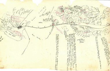
Hand-Drawn Map Centred on Ararat by Frank Lebbell Frost December 1916
... Victoria. Details road and railway and vegetation with comments...-drawn map centred on Ararat, central Victoria. Details road ...This is one of the maps drawn by Frank L. Frost while he was beekeeping in North-East Victoria. This particular map may be reference in the "Wooden" Diary on page 11. Front Side: Hand-drawn map centred on Ararat, central Victoria. Details road and railway and vegetation with comments on flowering. Back Side: Comments in grey lead [ca 1923]hand drawn, hand-drawn, map, ararat, frost, beekeeper, beechworth honey -
 Tatura Irrigation & Wartime Camps Museum
Photograph, Arthur Knee, 1989
... Camp 13, Camp Road, Murchison, Victoria. Sewage treatment... 13 Camp 13, Camp Road, Murchison, Victoria. Sewage treatment ...Sewage treatment pond, camp 13, Murchison. German, Italian, Japanese POW's held here between 1941 - 1946. Camp 13, Camp Road, Murchison, Victoria. Sewage treatment plant.pow, internment camp, sewage treatment, murchison, victoria, camp 13 -
Ballarat Heritage Services
Photograph, Old Hepburn Hotel, 2019, 06/02/2019
... Colour photograph of the Old Hepburn Hotel in Main Road...Main Road, Hepburn, Victoria, Australia... in Main Road, Hepburn, Victoria. Old Hepburn Hotel, 2019 ...The Old Hepburn Hotel has been a watering hole in Heburn since the 1850s. The original building burnt down in a bushfire in 1906 but was rebuilt in 1912. The freehold on the building has been sold in early 2019, but it is not known what will happen to the venue. The hotel closed in midMarch 2019.Colour photograph of the Old Hepburn Hotel in Main Road, Hepburn, Victoria.old hepburn hotel, hepburn -
 Lakes Entrance Historical Society
Photograph, 1994 c
... / Bruthen Road, Victoria... of Bruthen, on the south side of the Bairnsdale / Bruthen Road ...Also second identical copyColour photograph of an iconic old building about a kilometre west of Bruthen, on the south side of the Bairnsdale / Bruthen Road, Victoriabuildings, local history -
 Glen Eira Historical Society
Album - Album page, Neerim Road, Circa 1972
... Neerim Road, Caulfield, Melbourne, Victoria, Australia ...This photograph is part of the Caulfield Historical Album 1972. This album was created in approximately 1972 as part of a project by the Caulfield Historical Society to assist in identifying buildings worthy of preservation. The album is related to a Survey the Caulfield Historical Society developed in collaboration with the National Trust of Australia (Victoria) and Caulfield City Council to identify historic buildings within the City of Caulfield that warranted the protection of a National Trust Classification. Principal photographer thought to be Trevor Hart, member of Caulfield Historical Society. Most photographs were taken between 1966-1972 with a small number of photographs being older and from unknown sources. All photographs are black and white except where stated, with 386 photographs over 198 pages. "Edenkillie" was the home of Frederick Jowett, Caulfield's shire secretary and town clerk from 1887 to 1921. The Outer Circle Railway's Oakleigh section opened 1890 and closed 1895. Victorian Heritage database (as of 26/10/2021) HO45 Edenkillie https://vhd.heritagecouncil.vic.gov.au/places/35545 "Edenkillie" at 37 Neerim Road, Glenhuntly, is a substantial two storeyed polychrome brick villa, built for Frederick Jowett, municipal secretary, in 1890. It has aesthetic, historical and social significance. "Edenkillie's" aesthetic value derives from its survival as a substantially intact example of a common villa form expressed in polychrome brickwork. Its historical significance lies in its association with Frederick Jowett, Shire of Caulfield secretary and town clerk for over three decades. Its social significance is derived from the building's ability to demonstrate the kind of lifestyle which a local government administrator could enjoy during the Land Boom.Page 145 of Photograph Album with four landscape photographs from Neerim Road: two photographs of No 37 and two of the Outer Circle Railway Reserve.Handwritten: Neerim Road [top left] / 37 NEERIM ROAD 1OCT 1972 [under top left photo] / 37 NEERIM RD 1 OCT 1972 [under top right photo] / OUTER CIRCLE RAILWAY RESERVE MURRUMBEENA [under bottom left photo] / 145 [bottom left]trevor hart, neerim road, murrumbeena, caulfield, edenkillie, glen huntly, polychrome brick, mansions, frederick jowett, town clerks, shire of caulfield, outer circle railway, railways, parks and reserves, outer circle railway reserve, cast iron work, verandahs, balconies -
 Glen Eira Historical Society
Album - Album page, Orrong Road, Circa 1972
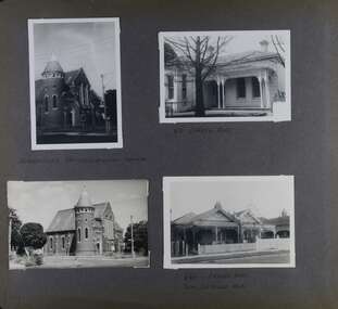
... 84-86 Orrong Road, Elsternwick, Melbourne, Victoria ...This photograph is part of the Caulfield Historical Album 1972. This album was created in approximately 1972 as part of a project by the Caulfield Historical Society to assist in identifying buildings worthy of preservation. The album is related to a Survey the Caulfield Historical Society developed in collaboration with the National Trust of Australia (Victoria) and Caulfield City Council to identify historic buildings within the City of Caulfield that warranted the protection of a National Trust Classification. Principal photographer thought to be Trevor Hart, member of Caulfield Historical Society. Most photographs were taken between 1966-1972 with a small number of photographs being older and from unknown sources. All photographs are black and white except where stated, with 386 photographs over 198 pages. Victorian Heritage Database H0704 FORMER UNION CHURCH 84-86 ORRONG ROAD ELSTERNWICK https://vhd.heritagecouncil.vic.gov.au/places/428 The Former Union Church, Elsternwick, designed by the architect George de Lacy Evans, and erected in 1889-90 is a building of historical and architectural significance for the following reasons:- (1) it is a rare and well- developed example of the early French Gothic manner as popularised through the muscular Victorian re-interpretation of English architect William Burgess, which in turn were derived from the publications of EE Viollet-le-Duc. Other Victorian cases of detailing derived from Viollet-le-Duc include Barwon Park (1868), the Presbyterian Church at Skipton (1871), the Bourke Street West Police Station by Bindley and Brittingham (PWD) dating from 1888-9 and the Lutheran Manse, East Melbourne by JAB Koch (1890). However, none of these buildings relates closely in form to the Union Church, Elsternwick. The only building which has been identified as closely comparable is The Bairnsdale Court House by AJ Macdonald (PWD) which dates from 1892. (2) the use of bright red brickwork is of significance, as the Former Union Church is believed to be only the second church building in Victoria to employ this material as a matter of conscious choice. Amongst red brick churches, it is thought to be preceded only by Reed, Henderson And Smart's Sacred Heart (1884), a Renaissance inspired design. (3) the building is believed to be a rare, possibly unique, surviving example of a church building erected for dual use by the Congregationalists and Baptists. In 1894 it was bought by the Congregationalists and continued as a Congregational Church until the formation of the Uniting Church.Page 165 of Photograph Album with four photographs, two of a church with the other two of houses on Orrong Road.Handwritten: ELSTERNWICK CONGREGATIONAL CHURCH [under top left photo] / 82 ORRONG ROAD [under top right photo] / 663-1 ORRONG ROAD / SEMI - DETACHED PAIR / 165 [bottom left]trevor hart, elsternwick congregational church, king street, orrong road, church, elsternwick, red brick, former union church, early french gothic style, architects, george de lacy evans, baptist church, conical towers, houses -
 City of Whittlesea
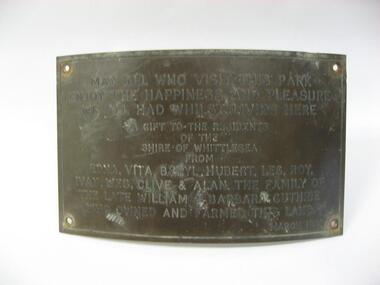
Plaque (item) - Norris Bank Reserve Plaque, Guthrie Family Plaque
... McLeans Road, Bundoora, Victoria ...May all who visit this park / enjoy the happiness and pleasure / we all had whilst living here / a gift to the residents / of this / Shire of Whittlesea / from / Edna, Vita, Beryl, Hubert, Les, Roy / Ivan, Wes, Clive & Alan the family of the late William & Barbara Guthrie / who owned and farmed this land / March 1981norris bank reserve -
 City of Whittlesea
Photograph (item) - Photographs - Buildings, Cyclists Rest Café Epping
... Epping Road, Epping, Victoria ...later became Shallard's Milk BarCyclists Rest Café Epping - 1915hotels -
 City of Moorabbin Historical Society (Operating the Box Cottage Museum)
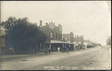
Photographs , Postcards x4 Charman Rd Cheltenham c 1910, c1910
... 4x Black & White Postcards c 1910 of Charman Road... of Charman Road Cheltenham Victoria Photographs , Postcards x4 ...After the arrival of the Cheltenham Railyway Station Charman Road became the main shopping centre. From 1 small shop - Mrs Meeres who sold sweets, school requisites and drapery - it proceeded to develop throughout the 1890's with various traders until the 1910 Postcards show many shops on both sides of the road, Stephen Charman, aged 21years, arrived in Melbourne in 1842 as one of Henry Dendy's Emigrants. 1852 he purchased 160 acres for £328 bounded by Charman Rd and Balcome Rd. 'The Spring' was an important water source for the local Aboriginal people and then for the early settlers. Charman's first wife Harriet and their infant child died and in 1850 he married a widow with 5 children, Mary Gettens. Their first home was made of wattle and daub and they had 7 more children. Later a weatherboard cottage was built c 1855 Together they developed a market garden and specialized in marigolds which were sold for medicinal purposes to the Melbourne Chemists - Martin & Pleasance . The first Methodist Church Services were held at Spring Grove and the Charmans donated land in 1857 for the first Chapel, Cemetery and Primary School . Mary died 1870 and Stephen married again and moved to Gippsland where he died aged 85 in 1906 Stephen and Mary Charman were pioneer market gardeners in Moorabbin Shire 1842 and were involved in the development of Church, school and community in the area now called Cheltenham. Charman Road Cheltenham was a boundary of their land.4x Black & White Postcards c 1910 of Charman Road Cheltenham VictoriaFront; CHARMAN RD. CHELTENHAM P. FAIRLAM PHOTOfairlam p, cheltenham railway station, moorabbin, cheltenham, dendy henry, dendy's special survey 1841, assisted emigrants early settlers, pioneers, market gardeners, marigold flowers, pharmacy, charman stephen, gettens mary, charman harriet, methodist church, primitive methodists, box william, box elizabeth, state schools, education, moorabbin shire, moorabbin roads board, city of moorabbin, kingston city council, cancel, cheltenham primary school -
 Tatura Irrigation & Wartime Camps Museum
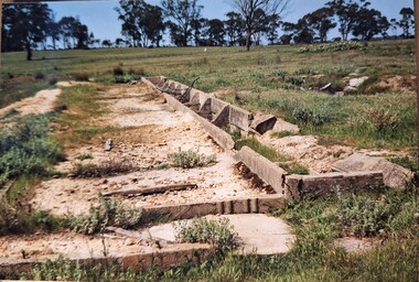
Photograph, Arthur Knee, Camp 13 latrine block remains, 1989
... Camp 13, Camp Road, Murchison, Victoria. Concrete remains... Camp 13, Camp Road, Murchison, Victoria. Concrete remains ...Camp 13, German compound. Latrine block, concrete remains, eucalyptus in background.Camp 13, Camp Road, Murchison, Victoria. Concrete remains, latrine block.camp 13, pow, german pow, internment camps, ruins, murchison victoria, latrine remains camp 13 -
 Mont De Lancey
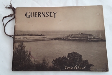
Booklet, The Star and Gazette Company Ltd, The Bailiwick of Guernsey, 1921
... , Victoria Road, Wandin North, Victoria, Australia. With Compliments.'...'. It was given to 'Mr.W.T. Sebire, Victoria Road, Wandin North, Victoria ...A historical descriptive booklet describing the charms and amenities of the wonderful island of Guernsey and all it has to offer. It includes archaeology, schools and colleges, churches, yachting, agriculture, sports, the growing industry. It has small sections on Alderney and Sark.A slim rectangular brown toned softcover booklet with Guernsey printed in black lettering at the top of the front cover and Price 6d. net printed in white lettering at the bottom right. The front and back covers depict a large overall scene of Guernsey from the land looking over the water. The Bailiwick of Guernsey: (The Islands of Guernsey, Alderney and Sark) is printed on the title page with a sepia coloured photograph of the reception of their majesties the King and Queen, and Princess Mary on the occasion of their visit, July11, 1921. There are many black and white photographs throughout the booklet. It has brown thin cord tied on the spine. 24p.non-fictionA historical descriptive booklet describing the charms and amenities of the wonderful island of Guernsey and all it has to offer. It includes archaeology, schools and colleges, churches, yachting, agriculture, sports, the growing industry. It has small sections on Alderney and Sark.history booklet, guernsey history -
Tatura Irrigation & Wartime Camps Museum
Photograph, Arthur Knee, 1989
... Camp 13, Camp Road, Murchison, Victoria. Concrete pit... pow internment camp Camp 13, Camp Road, Murchison, Victoria ...Camp 13, concrete pit, rolled barbed wire, near site of Camp 13 administration area.Camp 13, Camp Road, Murchison, Victoria. Concrete pit and tangled barbed wire.camp 13, murchison victoria, pow, internment camp -
Tatura Irrigation & Wartime Camps Museum
Photograph, Arthur Knee, 1989
... Camp 13, Camp Road, Murchison, Victoria. Red gum globe..., Murchison Victoria Globe of World wood work POW Camp internees ...Camp 13 artifact (photographed) red gum globe of world on carved stand made by POW. Purchased by Guard George Campbell. As at 1989 in Campbell's WW2 army collection.Camp 13, Camp Road, Murchison, Victoria. Red gum globe of the world on carved standcamp 13,, murchison victoria, globe of world, wood work, pow, camp internees, carved wood, george campbell -
 Lakes Entrance Historical Society
Photograph, 1999
... tree at Mairburn Road, Metung, Victoria.... Moreton Bay Fig tree at Mairburn Road, Metung, Victoria ...Colour photograph of a well established Moreton Bay Fig tree at Mairburn Road, Metung, Victoria.gardens, trees -
 Lorne Historical Society
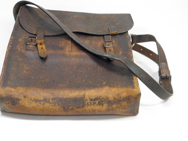
satchel, toll gate satchel, 1930?
... satchell used collecting tolls on great ocean road victoria... on great ocean road victoria the springs 1930/s last toll on great ...satchell used collecting tolls on great ocean road victoria the springs 1930/slast toll on great ocean road satchel