Showing 11735 items
matching history victoria
-
 Warrnambool and District Historical Society Inc.
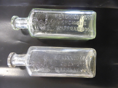
Bottle, R F Kennedy & Co x2, Early 20th century
These bottles were used in the Warrnambool pharmacy of R. F. Kennedy & Co. Richard Frank Kennedy (1826-1903) was born in England and came to Warrnambool in the early 1880s, establishing a pharmacy in Timor Street. This was a retail, wholesale and manufacturing business. In 1891 Kennedy erected a new building which was described as one of the most elegant and best-stocked chemist’s shops in Victoria. Kennedy was active in Warrnambool community affairs and was a foundation member of the Warrnambool Bowls Club, being its first Vice-President and an early President. His business continued on after his death, trading as ‘R.F.Kennedy and Co.’ Richard Frank Kennedy was one of the most significant businessmen in Warrnambool in the late 19th century. The products of his shop and factory were distributed all over Victoria and beyond. These bottles are good examples of the types used in the Kennedy pharmacy. They show the well-known Kennedy lighthouse symbol. Warrnambool still has two working lighthouses today. These are two clear glass chemist’s bottles. They are identical in size and shape. They have a rectangular-shaped body with rounded edges, a circular-shaped neck and a moulded top with an opening. There are no stoppers. The sides of the bottles have the Kennedy logo of a lighthouse on a rocky cliff on the coastline with ships in the distance and the name of the chemist (R.F.Kennedy). ‘2/3 viii’ ‘R.F.Kennedy & Co. Chemists Warrnambool’ ‘L 389 M’ ‘A.G.M.’ r.f.kennedy,, warrnambool chemist, chemists in warrnambool, history of warrnambool -
 Warrnambool and District Historical Society Inc.
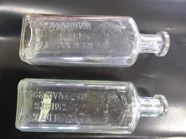
Bottle, R F Kennedy & Co, Early 20th century
These bottles were used in the pharmacy of R.F.Kennedy and Co. of Warrnambool. Richard Frank Kennedy (1826-1903) was born in England and came to Warrnambool in the early 1880s. He established a pharmacy in Timor Street. This was a retail, wholesale and manufacturing business. In 1891 Kennedy erected a new building and his business there was described as one of the most elegant and best-stocked chemist’s shops in Victoria. Kennedy was active in Warrnambool community affairs and was a foundation member of the Warrnambool Bowls Club, being its first Vice-President and an early President. After his death the pharmacy business continued, trading as ‘R.F.Kennedy & Co.’ Richard Frank Kennedy was one of the most significant businessmen in Warrnambool in the late 19th century. The products of his pharmacy wee distributed all over Victoria and beyond. His lighthouse logo was well-known. These bottles are good examples of those used in the Kennedy business. These two identical bottles are made of clear glass. They have rectangular-shaped bodies with rounded edges, circular-shaped necks and moulded circular tops with openings. One has a glass stopper. The sides of the bottles have the Kennedy logo of a lighthouse on a rocky cliff on the coastline with ships in the distance and the name of the chemist. There is some discoloration inside one of the bottles. ‘2/3 vi’ ‘R.F.Kennedy & Co. Chemists Warrnambool’ ‘M’ r.f. kennedy, warrnambool chemist, chemists in warrnambool, history of warrnambool -
 Warrnambool and District Historical Society Inc.
Glass, Warrnambool Premier Town, 1980s
This glass is a souvenir of the awarding to Warrnambool of the title of Victoria’s Premier Town for the period 1979 to 1982. The Premier Town Awards were given by the State Government to the town or city that best protected and enhanced its environment. Factors contributing to this included waste management, litter control and environmental improvements. Warrnambool won the award in 1958, 1979-82 and 1988-1991. This souvenir glass is kept as an example of the type of souvenir sold on the occasion of Warrnambool’s winning the Premier Town Award for 1979 to 1982. It will be useful for display. This is a drinking glass in the form of a goblet with a circular base, a thin stem and a top with gold edging around the rim. On the side of the glass there is a Warrnambool logo and wording in gold lettering. ‘Warrnambool Premier Town ‘ ‘1979-82’ ‘Victoria Australia’ premier town awards, history of warrnambool -
 Warrnambool and District Historical Society Inc.
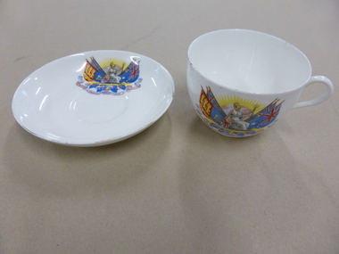
China, Cup & Saucer, 1930s to early 1940s
These items were made in the 1930s or 1940s for sale as souvenirs of Empire Day in Victoria. As they were made by Royal Doulton of England they were high-quality souvenirs. Empire Day was established in 1905 to commemorate the reign of Queen Victoria and to promote and celebrate the importance of the British Empire in Britain and in the associated British Empire countries. It was celebrated on 24th May, the date of Queen Victoria’s birthday. In Victoria the day was celebrated with a school holiday and half-day business holiday, street and shop decorations, bonfires, concerts, processions etc. In 1958 Empire Day became known as Commonwealth Day. These items have no known local provenance but they were typical of the souvenirs that sold in the first half of the 20th century in Warnambool and all other parts of Australia around the time of Empire Day, May 24th . It will be useful for display. This cup and this saucer are made of white china with coloured images of Britannia, the rising sun, British flags, scrolls and the names of British Empire countries on each item. The cup rim and the saucer edge originally had gold trim but the gold has almost disappeared. The cup and the saucer have the name of the distributor and the maker on the base. ‘Empire Day, May 24th , Africa, Australasia, Canada, India’ empire day, history of warrnambool, empire day cup and saucer -
 Warrnambool and District Historical Society Inc.
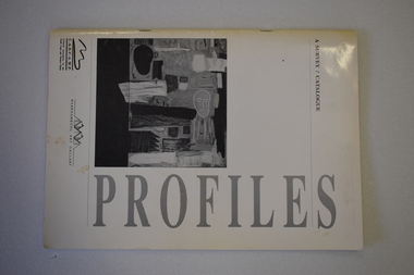
Catalogue, Profiles Warrnambool Gallery, 1994
This booklet is a catalogue of most of the works of art that were displayed in an exhibition in the Warrnambool Art Gallery in 1994. It was described as ‘a celebration of artists committed to living and working in country Victoria’. It was intended to be the first of similar exhibitions and was initiated by the Warrnambool-based Cultural Association of the South Coast and Western Plains. The Warrnambool Art Gallery was officially opened in 1886 though the local Mechanics’ Institute and Museum had been collecting works of art before this date. When the Mechanics’ Institute building was taken over for Council use in 1963 the Art Gallery ceased to exist and the works put in storage. The Gallery re-opened in temporary premises in 1971 and the present Warrnambool Art Gallery, a memorial to Fletcher Jones, was opened in 1986 in Liebig Street. This is an interesting catalogue as it is one of the few examples we have of the work of the Cultural Association of the South Coast and Western Plains. This Warrnambool-based group operated for a short time only in the 1990s.This is a soft cover booklet of 40 pages. It is bound with metal staples. It has a white cover with black printing and reproductions of black and white works of art on the front and back covers. The booklet contains reproductions of the works of art (in black and white) by 34 south west Victoria artistswarrnambool art gallery, history of warrnambool -
 Warrnambool and District Historical Society Inc.
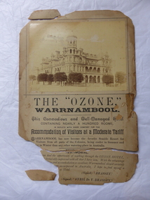
Poster, Ozone Hotel, 1896
This poster advertises the Ozone Hotel in Warrnambool. The poster can be dated to 1896 or thereabouts as it quotes the testimonials of the Governor of Victoria, Lord Brassey and Lady Brassey who stayed at the hotel twice in 1896. The Ozone Hotel, at the corner of Koroit and Kepler Streets, Warrnambool, was opened in 1890 as the Grand Ozone Coffee Palace, a temperance hotel. In 1891 it was granted a colonial wine licence and in 1895 it became known as the Ozone Hotel (a private hotel with superior accommodation). From 1894 to 1907 Thomas Randall was the proprietor. In 1923 the hotel, by then known as Hotel Mansions, became a fully licensed hotel. The building was burnt down in 1929. Although very tattered, this is a significant item. It is an original poster of the Ozone Hotel. The building (Grand Ozone Coffee Palace/Ozone Hotel/Hotel Mansions) was very important in Warrnambool’s history. It was the grandest building ever erected in Warrnambool and a memento of the days when temperance hotels were prevalent in Victoria and tourism was beginning to be important in Warrnambool. This is an advertising poster made of buff-coloured, heavyweight cardboard. It has a sepia-coloured photograph of the Ozone Hotel at the top and black printed material on the bottom half. The poster is completely torn in two with two edge sections also detached. Parts of the top left and bottom left corner are missing. There is evidence of adhesive tape having been used for mending purposes in the past and the whole poster is a little grubby. The paper is now very brittle. ‘The “Ozone” Warrnambool’ ‘This commodious and well-managed hotel containing nearly a hundred rooms, is replete with every comfort for the accommodation of visitors at a moderate tariff …..’ ozone hotel, warrnambool, history of warrnambool -
 Warrnambool and District Historical Society Inc.
Document, Wollaston sale, 1919
This is a poster advertising the sale of part of the Wollaston Estate in Warrnambool in 1919. The sections for sale were Allotments 1, 18 and 19 which included the Wollaston Homestead. The original Wollaston property of 679 acres was selected by Thomas Manifold in the late 1840s. This land, on the northern side of the Merri River, near the Woodford Road was three kilometres from the Warrnambool town. The first farmer we know who leased the property was William Simpson. Walter Manifold inherited the property and he took it over in 1884. The swing bridge he built in 1890 still stands today. In 1919 the Closer Settlement Board of Victoria acquired Wollaston and 17 lots were sold to returned soldiers for farming purposes. By 1930 there were only five soldier settlers remaining. In 2009 further subdivision took place with lots sold for residential purposes. The homestead allotments were sold separately in 1919 with various owners of the homestead itself recorded since that time. This poster is of interest as it shows the areas of the Wollaston Estate which were sold in 1919. The history of this estate is well-documented and of importance in the history of Warrnambool. This is a sheet of paper with red and black printing and a map of the Wollaston Estate which is photo-lithographed. The sheet has been folded three times. It has some small tears at the top of the page. wollaston, history of warrnambool, walter manifold -
Warrnambool and District Historical Society Inc.
Plate, City of Warrnambool, Late 20th century
This plate would have been part of a crockery set used by the Warrnambool City Council at civic functions and receptions. It probably dates from the late 20th century. It was made by Westminster China which was a business established by Stanley Rogers and Sons Limited in Cheltenham, Melbourne in 1954. In 1977 the business was moved to Sandringham, Melbourne and by the 1990s it was mainly producing items for the hospitality sector. Warrnambool became a Municipality in 1865, a Borough in 1863, a Town in 1883 and a City in 1918. The seal and motto, ‘By These We Flourish’ were designed and drafted by John Macdonald, an original member of the Municipal Council in 1856 and the first Head Master of Warrnambool’s National School in 1850. This plate is of interest as one of a set used by the Warrnambool City Council in the late 20th century. This is a white china plate, slightly bowl-shaped, with a gold strip around the rim. The gold is partly fading. The plate has the City of Warrnambool crest in blue and yellow on one outer edge of the plate. ‘City of Warrnambool Victoria’ ‘By These We Flourish’ warrnambool city council, history of warrnambool -
 Kiewa Valley Historical Society
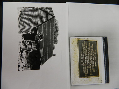
Wilkinson Lodge - copies of 6 photos, 1 plaque, 1 article
Wilkinson's Hut was built for the State Electricity Commission of Victoria in 1932 as a permanent residence for the snow research program manager, who was the resident engineer of the Kiewa Hydro Electric Scheme. The hut was sold in 1948 to the Ski Club of Victoria / Victorian Alpine Club and renamed Wilkinson Lodge. In 1958 it was sold to the Melbourne Bushwalkers Club. It was burnt down on 17th January 2004.Wilkinson Lodge was located at Wallace Gap on the Bogong High Plains and was the first S.E.C.V. permanent residence for the workers of the Kiewa Hydro Electric Scheme. It is also an early built lodge owned briefly 1946 - 1958 by the Ski Club of Victoria / Victorian Alpine Club and used by skiers before other lodges were built at Falls Creek. It was used by bushwalkers until it was burnt down thus in itself depicting part of the history of the area.5 pages of copies of photos of Wilkinson Lodge, 1 page of a copy of the destruction of Wilkinson Lodge (6 small photos), 1 page of a copy of a plaque titled 'This cottage' and 1 page of an article from the Border Mail (newspaper) dated 19th Jan. 2004.wilkinson hut; secv; ski club of victoria; melbourne bushwalkers club; fire -
 Kiewa Valley Historical Society
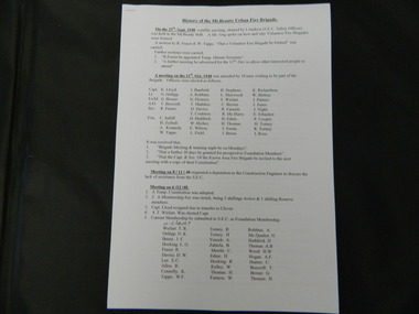
Papers - History of the Mt Beauty Fire Brigade
The Mt Beauty Fire Brigade commenced under the State Electricity Commission of Victoria in 1948. It was a (Country Fire Authority) C.F.A. Brigade from December 1961 and later an Urban Fire Brigade. The Fire Brigade and its Ladies Auxillary provided many community activities as well as protecting the population.The State Electricity Commission of Victoria established the Mt Beauty Fire Brigade during the construction of the Kiewa Hydro Electric Scheme. Its Ladies Auxillary was very active and involved, serving the community by raising money for the brigade and providing social occasions such as 'Deb' balls.One set of two pages and one set of eleven pages of the History of the Mt Beauty Fire Brigade and Mt Beauty Urban Fire Brigade respectively. Typed and photocopies.mt beauty fire brigade; ladies auxillary; deb balls -
 Kiewa Valley Historical Society
Folder - History of Mt Beauty Township, 1980's
'The Kiewa Story' by Graham Napier requested submissions by residents of Mt Beauty for inclusion in his book. The submissions give a lot of detail and cover many subjects.An in-depth history as remembered by people who lived and worked on the Kiewa Hydro Electric Scheme from the 1940's onwards. Many lived locally in the construction towns of Mt Beauty and Bogong.A collection of papers in a white folder with submissions by locals as requested for the book "The Kiewa Story" by Graham Napier, Geoff Easdown in 1986. There is an Index and also included a note that' submissions tell the story of the community involvement in Mt Beauty's development.kiewa story; graham napier; mt beauty; kiewa hydro electric scheme; state electricity commission of victoria; communities -
 Kiewa Valley Historical Society
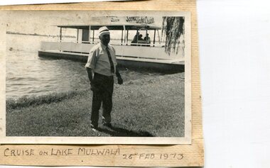
Photographs x 3- Cruise on Lake Mulwala, 25/2/1973
Lake Mulwala is a man–made reservoir created through the construction of the Yarrawonga Weir across the Murray River, is located between Bundalong and Yarrawonga in Hume region of Victoria and Mulwala in the Riverina region of New South Wales, in eastern Australia. The weir was constructed in 1939 to provide water for irrigation of the surrounding district. The weir also serves as a crossing of the Murray between the two towns. It is a popular tourist destination for boating, fishing and other water recreation.Photographs demonstrate local Kiewa Valley residents enjoying a visit to the picturesque area of Lake Mulwala. Also provides a pictorial history of 1973.3 black and white photographs mounted on buff card. Photographs of a cruise on Lake Mulwala 25th Feb. 1973 1. Photo of unidentified man standing on the shore of Lake Mulwala beside cruise launch. 2. Group photo of people standing by cruise boat as others disembark. Woman in centre holding handbag may be Clare Roper (unconfirmed) 3. Photo of 2 men aboard cruise launch looking out over Lake Mulwala1. Handwritten at bottom of photo in black ink. 'Cruise on Lake Mulwala. 25th Feb. 1973' 2. Painted sign above cruise launch- Scenic Lake Cruises 3. No markingsclare roper -
 Kiewa Valley Historical Society
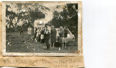
Photographs x 2- Bus tour of Wallaces Hut, 20/02/1970
Wallace's hut was built in 1889 and is probably the oldest surviving hut on the high plains of north-east Victoria. It was built in six weeks by Irish immigrant brothers Arthur, William and Stewart Wallace among old snow gums on a grassy plain above the snowline. The brothers held grazing leases on the High Plains and the hut was built to provide shelter for the cattlemen working there. It is probably the oldest hut on the Victorian high plains. It is part of the early history of hydroelectricity in the state and has links with early SEC meteorological data recording in the area Apart from its historical significance, Wallace’s Hut is a popular stop for tourists and photographers and is the starting point for the Wallace’s Heritage trail, which is a popular and well used hiking track, by locals and visitors alike.2 black and white photographs mounted on buff card. Photos taken during a bus trip to Wallace's Hut on Feb. 20, 1970 1. Group of local Kiewa Valley residents on a bus tour to Wallace's hut 2. Group of adults and children pictured outside Wallace's hut1. Handwritten in black ink on bottom of photo 'Wallace's Hut, Bogong High Plains, 20 Feb, 1970 2. No markingswallace's hut, bogong high plains, bush walking, cattlemen -
 Kiewa Valley Historical Society
Photographs of small box originally used to contain sensitized photographic paper
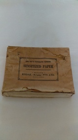
The Junction Dam and Clover Dam Power Station, stages of the Kiewa Hydro-Electric Scheme, were needed to meet the increased power demands of the wartime industry in Victoria. Clover added 26 megawatts to the grid. Junction Dam was completed and ready to hold water by September 1943, but was emptied in December 1943 and not filled again until May 1944. Construction of Clover Power Station commenced in July 1941 and both turbines were in service by May 1945.Clover Power Station and Junction Dam were part of the Kiewa Hydro Electric Scheme constructed by the State Electricity Commission of Victoria. SECV official photographers took photographs of most stages of construction of the Hydro Electric Scheme and referenced each photo with a number and dating system as an historical record and for reference for other projects. This provided a thorough history of the construction of the Hydro Electric Scheme, some of the workers involved in its construction and the infrastructure supporting its construction, such a Bogong Village.Small light brown cardboard box originally containing sensitized photographic paper, now containing a range of black and white photographs of the Kiewa Hydro Electric System taken by the official SECV photographer Box has some damage – Front panel on lid is missing. Top has a puncture in top right corner and some peeling of paper along sides and at edges. Printed on the top of the box in black ink: OPEN ONLY IN PHOTOGRAPHIC DARK ROOM SENSITIZED PAPER Manufactured by – KODAK (A/asia) PTY. LTD. Melbourne Australia Green and white sticker on right side of lid and bottom right side of box, torn at join 1. 1B1 Single Weight Soft. Available in Soft (1) Medium (2) Contrast (3) Extra Contrast (4) Single and Double Weight Stamped at bottom of sticker in grey ink G8087 CK photographic paper box; state electricity commission of victoria; official photographer; kiewa hydro electric scheme; clover power station; junction dam; bogong village -
 Kiewa Valley Historical Society
Photographs – Set of 10 black and white photographs and photocopies of original photographs documenting early residents of Bogong Village
Bogong Village, which was known as “The Junction”, is well recorded. The first tent camp was at the junction of Pretty Valley and Rocky Valley streams in the early 40’s. Further downstream were the sawmill, stables and blacksmith’s forge. Horses were the main mode of transport in the early days. The road to Bogong had reached the lookout spur just beyond Roper’s Spur track just before the 1939 fires. The early forties saw rapid growth of the village, with single and married men’s quarters, workshops, mess huts and administrative offices. The facilities necessary for communal living were quickly in place- a post office, police station, co-op store, medical centre, community hall/theatre, tennis courts and school. Much of the temporary accommodation that housed groups such as the Albion Quarrying Company were in the area now under water.This group of photographs are a pictorial record of the early history of the Kiewa Hydro Scheme, the people who worked in the background supplying administrative support and the workers and their families. It also shows a glimpse into how a large group of people from very diverse backgrounds came together to enjoy social activities and share each others companyGroup of 10 black and white photographs and photocopies of original photographs of varying sizes (some official SECV photos) Some Photos are labelled with the date and the names of SECV staff members. Depicting early life at Bogong Village 1. Group photo – Kiewa House Residents 1.8.41 (SECV official photo) 2. Female staff residents 3. Female office staff 4. Kitchen staff – Junction Mess (SECV official photo) 5. Male administration staff Bogong 6. Bogong Social Club fancy dress ball, 1940 7. Wives and children of SECV workers 8. Children in fancy dress 9. Opening of Volunteer Air Observers post 1943 10. Flag raising at opening of Volunteer Air Observers post 1. Printed under photo: STATE ELECTRICITY COMMISSION OF VICTORIA Date: 1.8.41 Time: 12.30pm No:K 435 Kiewa Hydro-Electric Works. Kiewa House Residents Back Row L to R: S.A. Salmon, W. Strachn, T.A Connors, W.J Norman, R.C Grealey, R.D Hegarty, Mrs Hegarty, W.R Morgan, S.A Clarke, P. Morgan, P.J. Harnetty, G.W Crouch. Front Row L to R: W.L Godfrey, R.S Hollands, Pte. R Charlesworth, R.L Dunn, N Caldwell, L.T Davies, I Webber, H.L Kendall, P Tiller, Ricky Hegarty, L.T Guy, M.C Cox, K.F Calder, D.S Gibson 2. Printed on bottom: Staff who lived at Kiewa House and worked in the Administration Office c 1943 Handwritten at bottom Priscilla Johnson (nee Reid) At top of page A GOOD LIFE: WOMEN’S RECOLLECTIONS OF LIFE IN THE UPPER KIEWA VALLEY 3. Printed under photo- Office Staff – Bogong 4. Printed under photo: STATE ELECTRICITY COMMISSION OF VICTORIA Date: 18.5.40 Time: 11.05am No:K 103. Kiewa Hydro-Electric Works. Kitchen Staff- Junction Mess. Opening night of the new staff mess Bogong. 5. Printed under photo -Administration staff Bogong 6. Printed under photo- The social club raised money for patriotic fund from fancy dress nights. (1st Fancy Dress Ball, Bogong 1940) 7. Printed above photo: ---- and family life begins (1942 Bogong) 8. Printed under photo: A favourite photograph 9. Printed under photo: STATE ELECTRICITY COMMISSION OF VICTORIA Date: 24.5.43 Time: 2.8pm No:K 1151 Kiewa Hydro-Electric Works. Bogong- Squadron Leader Leggett speaking at opening of Air Observer’s Post 10. Printed under photo: Raising the flag at the opening of the Volunteer Air Observer’s Post at Bogong - 1943 bogong village; kiewa hydro electric scheme; social activities; community clubs -
 Kiewa Valley Historical Society
Photographs – Set of 9 black and white photographs and photocopies of original photographs depicting the early days of Bogong Village during the 1940’s, circa 1940's
Bogong Village, which was known as “The Junction”, is well recorded. The first tent camp was at the junction of Pretty Valley and Rocky Valley streams in the early 40’s. Further downstream were the sawmill, stables and blacksmith’s forge. Horses were the main mode of transport in the early days. The road to Bogong had reached the lookout spur just beyond Roper’s Spur track just before the 1939 fires. The early forties saw rapid growth of the village, with single and married men’s quarters, workshops, mess huts and administrative offices. The facilities necessary for communal living were quickly in place- a post office, police station, co-op store, medical centre, community hall/theatre, tennis courts and school. Much of the temporary accommodation that housed groups such as the Albion Quarrying Company were in the area now under water.Pictorial history of the early years of Bogong Village including one photo taken following the devastating fires of 1939. Photos show the terrain in which Bogong Village was built, the early construction used for the temporary buildings and the housing and the amount of infrastructure required to accommodate the needs of the residents of the area including workers, their families and other support staff. Set of 9 black and white photographs and photocopies of photographs depicting early buildings at Bogong Village . Photos show very early construction buildings as well as the village in various weather conditions, including snowing and after bush fires. (some official SECV photographs) 1. Bogong Village in heavy snow 2. Bogong Township during heavy snow (SECV Official Photo) 3. VIP Lodge at Bogong in the snow 4. Bogong Village - circa 1940’s 5. Bogong Village under street lights 6. Lewis Construction Camp (SECV Official Photo) 7. Albion Quarrying Co. Camp (SECV Official Photo) 8. Tent camp and early buildings following 1939 fires 9. Typical house – Bogong Village 1. Handwritten under photo – August 1948 2. Printed under photo: STATE ELECTRICITY COMMISSION OF VICTORIA Date: 25.8.48 Time: 9am No:K 4680 Kiewa Hydro-Electric Works. Bogong Township 3. Handwritten on back of photo- V.I.P. Lodge, Bogong 4 – 5. No markings 6. Printed under photo: STATE ELECTRICITY COMMISSION OF VICTORIA Date: 28.11.40 Time: 1.40pm No:K284 Kiewa Hydro-Electric Works. Lewis Construction Camp 7. Printed under photo: STATE ELECTRICITY COMMISSION OF VICTORIA Date: 11.1.41 Time: 10.40am No:K294 Kiewa Hydro-Electric Works. Albion Quarrying Co. Camp – Bogong. Handwritten on back of photo: On the floor of the present dam 8. No markings 9. Printed under photo: STATE ELECTRICITY COMMISSION OF VICTORIA Date: 11.1.46 Time: 1.23pm No:K2181 Kiewa Hydro-Electric Works. Bogong – Typical House bogong village; 1939 fires; kiewa hydro electric scheme; -
 Kiewa Valley Historical Society
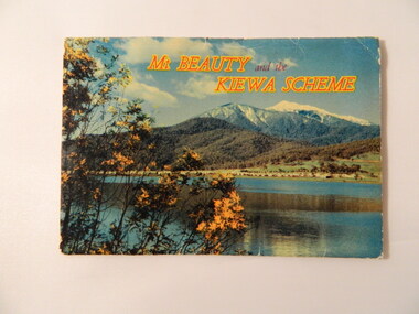
Postcard (fold out) - Mt Beauty and the Kiewa Scheme, Victoria, Mt Beauty and the Kiewa Scheme, c1960s
S. K Pearce owned shops in Mt Beauty and Tawonga. The postcard was used for tourism to attract visitors to the Mt Beauty township and the Kiewa Scheme on the Bogong High Plains. The postcard gives a brief history of the town and area both created by the State Electricity Commission of Victoria.The photos are historically significant and include prominent places in the Kiewa Valley, Mt Beauty and the Bogong High Plains. S. K Pearce was a prominent shop owner in the area having shops in Tawonga and in Mt Beauty as seen in one of the photos. The postcards are of interest as they are an example of advertising for tourism in the 1960's.Fold out postcards including a panel on information on Mt Beauty and the Kiewa Scheme, 12 colored labelled photos, an address & letter written in black biro. Multiple copies.Letter from Roma to 'Dad and Chris'. Their address in Bayswater. Postage stamp from Mount Beautymt beauty, kiewa hydro electric scheme, s. k. pearce, tourism -
 Kiewa Valley Historical Society
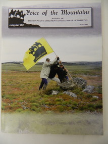
Journal - The Mountain Cattlemen's Association of Victoria - No. 29 (2006) x2, Voice of the Mountains, 2006
The High Plains Cattlemen's licenses expired in Aug. 2005 ending a 170 year history of alpine grazing in Victoria and Australia. This journal, No. 29, is published by the Mountain Cattlemen's Association "caring since 1835" and has articles and histories of the families and their activities. Many of the Mountain Cattlemen lived / live in the Kiewa Valley. This journal contains their history, activities and views.Stiff colored cardboard cover journal with title at the top of the cover. Consists of 56 pages. Centre 4 pages not numbered and are on yellow paper. Black and white photos are included.mountain cattlemen, bogong high plains, horses -
 Kiewa Valley Historical Society
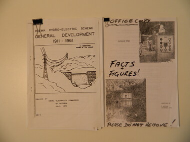
Papers - The Kiewa Hydro Electric Scheme x2, 1973 and 1993
1. Chronological account of the Kiewa Hydro Electric Scheme from 1911 to 1961 2.Victorian Hydro with technical facts and figures, with Aboriginal History of the region, Settlement of the Kiewa Valley, Origin of Names Both accounts are a history of the Kiewa Hydro Electric Scheme constructed by the State Electricity Commission of Victoria. The first is and abbreviated history of the scheme published by the SEC, the second is similar with 'facts & figures' accessed by Bill Sutton, (Mt Beauty resident and SEC worker) whose father worked on the scheme, and who enjoyed speaking to visitors and groups about the history of the area including some of the light hearted aspects of the history.The Kiewa Hydro Electric Scheme General Development 1911 - 1961 by SECV, July 1973. Consists of 22 A4 pages held within a folded A3 sheet Victorian Hydro compiled by W. Sutton Nov. 1993. Office Copy / Facts & Figures. Consists of 44 A4 pages held by a metal clip.kiewa hydro electric scheme, state electricity commission of victoria, bill sutton -
 Kiewa Valley Historical Society
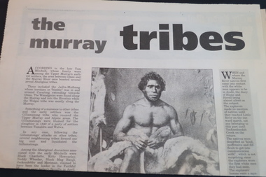
Newspaper Article - 'The Murray Tribes' and 'Back to Beauty', October 10th 1998
The Murray Tribes written by Cliff Chamberlain a general history of the Aborigines possibly as reported in previous newspapers. The Back to Beauty article was a report of the 50th anniversary of public education in Mt Beauty.The Murray Tribes visited the Alpine areas in pursuit of the Bogong Moth. Public Education began in Mt Beauty in 1948 as a result of the number of children living in the town. Their fathers working for the State Electricity Commission of Victoria on the Kiewa Hydro Electric Scheme.Newspaper Article entitled 'the murray tribes' and on the back 'Back to Beauty' - the Border Mail Saturday Oct. 10, 1998aborigines, bogong moth, public education, mt beauty -
 Kiewa Valley Historical Society
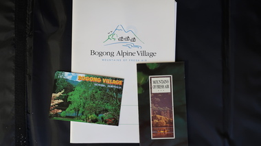
Papers - Bogong Village & the 'Commissioner's' Lodge & Progress Association Members, c 1997/1998
Bogong Village was built by the SECV in 1940 for the workers of the Kiewa Hydro Electric Scheme. In 1971, 30 houses were furnished for use as holiday homes for SEC personnel throughout the State. From 1989 to 1993 the houses were restored & renovated.During the 1990s the buildings in the village had been leased to private owners. Many of them rented their houses for tourists. The Commissioner's lodge was on the other side of the Mt Beauty - Falls Creek road, above Bogong Village. Wally Baldwin ran it in the 1960's.It was destroyed by the 2003 bushfires.These papers present a history of 'the Commissioner's lodge' and Bogong Village in the 1990's. The Progress Association was an active community group in 1963/64.Papers advertising Bogong Village & the Lodge for accommodation with rates 1997/1998. Describes the alternatives, maps and cafe hours, Also, 'Jan's Recollections' and on the back of these pages a hand written list of members of the the Progress Association 1963-64 as 'per Mr A. McCullough's spiel'. In original folder and includes a pamphlet & postcard.bogong village, secv lodge, lake guy, state electricity commission of victoria., kiewa hydro electric scheme, tourism, accommodation -
 Kiewa Valley Historical Society
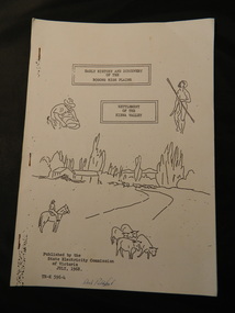
Booklet - Bogong High Plains & Kiewa Valley, Early History & Discovery of the Bogong High Plains & Settlement of the Kiewa Valley, July 1968
A brief history of the area including the Bogong High plains including aborigines and cattlemen. Settlement of the Kiewa Valley including cattlemen and families. A list of the Origin of names of places in the valley.SECV published this booklet using research resources available at the time and using current knowledge with regard to naming of places where the SECV worked and 'created'.Light cardboard cover with 3 staples and with 9 pages printed on one side. Text is boxed. Front cover has 5 simple sketches each of which covers the topics included in the booklet."Dick Puttyfoot" on front coverstate electricity commission of victoria., kiewa hydro electric scheme, kiewa valley, bogong high plains -
 Kiewa Valley Historical Society
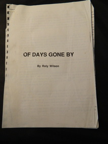
Booklet - Kiewa Hydro Electric Scheme, 'Of Days Gone By' by Roly Wilson
Roly Wilson lived in Tawonga milking cows in 1933 before working for the SECV on the Kiewa Hydro Electric Scheme with the diamond drilling crew.Personal history of Roly Wilson who lived and worked on the Kiewa Hydro Electric Scheme during the 1930s.27 pages stapled at the top left corner. Typed on one side only on each page with no photos.tawonga, kiewa hydro electric scheme, state electricity commission of victoria., roly wilson, diamond drilling -
 Kiewa Valley Historical Society
Papers - Edmondson's Hut, The letter is dated 8th October 1974
... to James Edmondson, Tawonga, Victoria. 2. Page headed History... in the history of Cattlemen's huts on the Bogong High Plains. education ...Edmondson's Hut is a cattleman's hut on the Bogong High Plains. Jim Edmondson obtained Run 33 (near Mt Nelse) in the early 1930s. He pre cut the timber at his property in Tawonga and along with iron for the walls, chimney and roof took it up to the Bogong High Plains on pack horse. The hut's wall and ceiling were lined and the hut had a 'fairly good floor and bunks'. In 1971 the hut was donated to the Education Department and was approved for transfer by the Lands Department in 1974. Bogong Outdoor School camp has been using the hut for students to camp in as well as National Fitness parties when walking in the area. The upper Kiewa Valley was settled from the mid 1860s and from its earliest days cattle were taken on to the Bogong High Plains to graze during summer. Jim Edmondson took his cattle from the Kiewa Valley to Mt Fainter and later to Run 33, near Mt Nelse. His hut is significant in the history of Cattlemen's huts on the Bogong High Plains.Four A4 typed sheets on white paper - 1. Acknowledgement of transfer of Edmondson's Hut. 2. History of Visitors (to the hut) Prior to 1971. 3. Two poems. 4. One poem 1. Emblem of Education Dept. Centre top of page. Addressed to James Edmondson, Tawonga, Victoria. 2. Page headed History and Visitors prior 1971. 3. My Old black Poley Cow (and) Roper's Track. 4. So Long, Mates!education department. edmondson's hut. bogong high plains. cattlemen. poetry. cattleman hut. bush walking. -
 Kiewa Valley Historical Society
Book - Kiewa Voters' Roll, Shire of Bright - Voters' Roll 1979 - Kiewa Riding, 1979
Electoral rolls list people who are registered and eligible to vote at federal, state, territory & local government elections and referenda. Prior to 1990 the rolls list voters in alphabetical order by surnames & first names within each Sub division of an electoral division of each State or Territory. The roll is useful & interesting for family historians and the study of demographics. Alex McCullough lived in the Shire of Bright and was on its Council. Electoral roles help to locate the residential address of a person in a particular year or over a period of years. They can be used as a substitute for census records for family historians and the history of a particular place in this case the Kiewa Valley - Tawonga and Tawonga South.Approx. 60 pages of firm yellow paper with black typed print on one side only in 'landscape' format. Held by three staples. Each page has column - numbered 1 to 943; Surnames in alphabetical order; Given names; Occupation; includes L (=land). Address followed by Lot number and parish. Includes Tawonga and Tawonga SouthOn the cover on the right hand side handwritten and difficult to read - "Jack? / Indi / Benambra / Nth Eastern / Division? of Dawson / 123 Victoria Rd. / Melbourne 3000"shire of bright; kiewa riding; voters roll; alex mccullough; tawonga; tawonga south -
 Kiewa Valley Historical Society
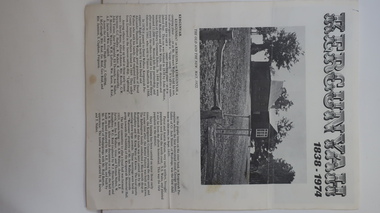
Leaflet - Kergunyah, Kergunyah 1838 - 1974, 1974
Kergunyah is a small town in the Kiewa Valley in north east Victoria. It is 10km south of Kiewa (town) and 23 km north of Dederang (town). it is farming country commencing in 1838, developing into a small community in 1974 with a School, Church, Post Office, Football Club, Young Farmer Club C.W.A. Netball Club, Card Club and Fire Brigade.Kergunyah is in the Kiewa Valley. Its history is important in the valley as it developed from a large pastoral run in 1838 into a small community supporting the local farming industry with essential organisations eg. school, fire brigade and social organisations eg. sporting teams, C.W.A.. Its history is significant as this leaflet has details of the organisations up to 1974 and this detail can be compared to organisations at Kergunyah today and can be compared to the history of other small rural communities. White stiff paper, folded to A4 size, with black and white photos on each of the 4 pages. Each page has detailed information under headings of community buildings and clubs in the small town. kergunyah; kiewa valley; small community; rural town; -
 Kiewa Valley Historical Society
Maps - Bogong x2, Tawonga, Omeo, Dargo, Victoria and others, 1. Bogong Alpine Area; 2. Bogong 8324; 3. Tawonga Topographical; 4. Omeo 8433; 5. Dargo 8323; 6. Victoria State
1. Bogong Alpine Area (outdoor Leisure Map. survey & Mapping Victoria, Government of Victoria, Edition 2, reprinted 1991 with an image of Mt. Feathertop on the front. Information for tourist in the Alpine National Park: Bogong Area. Including: recreational activities, history, weather and vegetation and a list of walks together with locality maps and photographs. The front cover has an image of Mt Feathertop against a blue sky with yellow writing 'Bogong Alpine Area', there is a yellow triangular block on the right hand top corner with black writing 'Outdoor Leisure Map. On the bottom edge is a block of yellow with black writing 'Survey & Mapping Victoria' and a light green map of Victoria with 'VICMSP' printed in white. 2. 8324 Bogong Victoria, Edition 1, Commonwealth of Australia 1981. A topographical Map: 1:100,000 scale (1 cm to 1 KM). Map has a red cover with white writing together with a white block and black writing and a map insert. 3. Tawonga Topographical Map - Forests Commission Victoria, / revised 5/9/77, DEG No. 68-G/399. A Tawonga 803 folded map in a beige colour with the back blank. 4. Omeo 8433 Victoria, Edition 1, Department of Natural Resources. The map has a red and white cover with black writing and a simple map of Australia at the bottom. 5. 8323 Dargo, Edition 1, Commonwealth of Australia. A red and white cover with a map insert. 6. Victoria State Map, Hema Maps, 2002. Hema Maps, State Map, colourful cover with a map of Australia and four tourism photographs. Scale 1: 850,000 An inscription handwritten in blue pen "Trappers Gap to Mitta Mitta 1" to 1 mile". There are some pen markings and notations of tracks.maps, bogong, omeo, tawonga, dargo, victoria, bogong alpine area -
 Kiewa Valley Historical Society
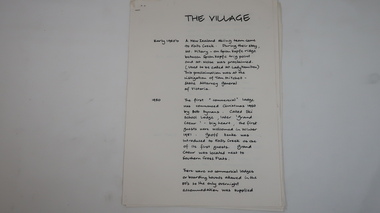
Papers - Falls Creek History, The Village
Timeline of Falls Creek during the 1950sFalls Creek is a snow resort on the Bogong High Plains, Victoria. The 1950s saw the village develop from its beginning to a popular ski resort.10 pages stapled top left corner. Includes a timeline of Falls Creek from early 1950s to the late 1950s. Titled 'The Village' and handwritten on one side only.falls creek, skiing, tourism, snow resort -
 Kiewa Valley Historical Society
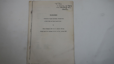
Memoir - Adrian Rufenacht, The Kiewa Project
Adrian Rufenacht, BCE (S.F.I.T. Zurich) MIE Aust. former Chief Civil Engineer of the State Electricity Commission of Victoria, retired 1967. Insight into the Kiewa Hydro Electric Scheme.First hand knowledge of the history of the Kewa Hydro Electric Scheme.40 pages stapled with 4 staples. The Kiewa Hydro Electric Scheme by Adrian Rufenacht, former civil engineer of SECV. Includes maps.On the front page - handwritten: 'To Ron / in memory of happy / and interesting times. / Adrianadrian rufenacht, khes, kiewa project, construction, secv -
 Kiewa Valley Historical Society
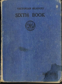
Book - English Reader, Victorian Readers Sixth Book, 1940
This book is a sixth grade reader which all Victorian students would have read during the 1940's. The book is made up of poems and stories, some which are still known and told today. Some pages have drawings that relate to the story of poems. This is historically significant due to showing what children read during the 1940's in schools across Victoria. Also it is a good comparison to what grade six children read now. Therefore it has good interpretation value and would be good in local school exhibitions. The names on the book indicate that this book came from a local famil, the Johnson and was read to two children of that family which gives this good social history. Some of the pages have had their pictured colored in by the student and words that have been underlined. These could have been harder words for the students to learn and seem advanced for grade six children to read. Book has a blue coverVICTORIAN READERS SIXTH BOOK, second edition, Victorian education stamp on front cover, SIXTH BOOK and EDUCATION DEPARTMENT VICTORIA ON SPIN. Inside cover has the names, Lorraine Margaret Johnson, Allan Johnson and Alice Payork? but that name has been crossed out and John with the son crossed out. All these names hand written in ink pen. book, school, reader, grade 6, department of education. children, stories, poems.