Showing 3760 items
matching surveyed
-
 Kew Historical Society Inc
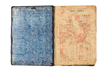
Plan, Melbourne & Metropolitan Board of Works : Borough of Kew : Detail Plan No.1590, 1905
The Melbourne and Metropolitan Board of Works (MMBW) plans were produced from the 1890s to the 1950s. They were crucial to the design and development of Melbourne's sewerage and drainage system. The plans, at a scale of 40 feet to 1 inch (1:480), provide a detailed historical record of Melbourne streetscapes and environmental features. Each plan covers one or two street blocks (roughly six streets), showing details of buildings, including garden layouts and ownership boundaries, and features such as laneways, drains, bridges, parks, municipal boundaries and other prominent landmarks as they existed at the time each plan was produced. (Source: State Library of Victoria)This plan forms part of a large group of MMBW plans and maps that was donated to the Society by the Mr Poulter, City Engineer of the City of Kew in 1989. Within this collection, thirty-five hand-coloured plans, backed with linen, are of statewide significance as they include annotations that provide details of construction materials used in buildings in the first decade of the 20th century as well as additional information about land ownership and usage. The copies in the Public Record Office Victoria and the State Library of Victoria are monochrome versions which do not denote building materials so that the maps in this collection are invaluable and unique tools for researchers and heritage consultants. A number of the plans are not held in the collection of the State Library of Victoria so they have the additional attribute of rarity.Original survey plan, issued by the MMBW to a contractor with responsibility for constructing sewers in the area identified on the plan within the Borough of Kew. The plan was at some stage hand-coloured, possibly by the contractor, but more likely by officers working in the Engineering Department of the Borough and later Town, then City of Kew. The hand-coloured sections of buildings on the plan were used to denote masonry or brick constructions (pink), weatherboard constructions (yellow), and public buildings (grey). Surveyed by the Board of Works in 1903 and published in 1904, Plan No.1590 shows development north of Cotham Road. While this plan includes built structures in Mary Street, Cotham Road, High Street, Park Hill Road, Kent Street, Ridgeway Avenue, and Ermington Lane (now Ermington Place), only part of this section was notated and coloured in this contractor’s copy. Numerous houses, large and small are named on the plan: ‘Cholula’, ‘Belper’, ‘The Uplands’, ‘Spring Grove’ facing Cotham Road; ‘Marion’ facing Kent Street; and ‘Kia Ora’ facing Ridgeway Avenue.melbourne and metropolitan board of works, detail plans, mmbw 1590, survey plans - borough of kew, cartography -
 Bendigo Historical Society Inc.
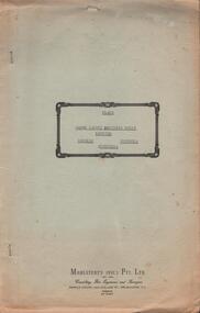
Document - HANRO COLLECTION: PLANS AND REPORT FROM FIRE ENGINEERS AND SURVEYORS, 1954/1960
Plans and Report from Fire Engineers and Surveyors:- Green Card has a rectangular box with an ornate border in the centre of the front page. Inside the border is typed in black *Plans, Hanro (Aust) Knitting Mills Limited, Bendigo Victoria Australia. At the bottom:- Mahlstedt's (Vic) Pty Ltd. (est. 1884). Consulting Fire Engineers and Surveyors. Temple Court, 422 Collins Street., Melbourne C.1. Telephone 673069. Inside the folder is the Key to Detail Block Plans & Fire Surveys. Correspondence from Mahlstedt's Pty Ltd to Edward Lumley and Sons, Insurance Brokers regarding a new survey and the changes to the building with respect to fire hazard. Main report recommendations and general information on the building. Blue print of Shirt Factory, Inglewood Road No. 1061 by Welmar Ltd Bendigo. Small blue print of the main buildings showing different work areas. Blue print No.1119 of John Brown Industries Ltd Alley Street Bendigo showing work areas. Box 116AMahlstedt's (Vic) Pty Ltdhanro, clothing, plans and reports, edward lumley & sons pty ltd. hanro knitting mills. mahlstedt's (vic) pty ltd. welmar ltd bendigo. john brown industries ltd. -
 City of Moorabbin Historical Society (Operating the Box Cottage Museum)
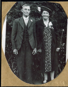
Photograph, Alfred Amos , Gertrude Emma Box 1941, c1941
William and Elizabeth Box migrated from Sussex England c1850 and established a market garden in the area of Henry Dendy's 'Special Survey Brighton 1841' in the Parish of Moorabbin, County of Bourke. William's parents, George & Mary Box followed in 1856 bringing 6 of their 10 children and joined William in East Brighton ( Bentleigh) Gertrude Emma Box is a descendant of this family.The Box family were pioneer settlers in the area of 'Henry Dendy's Special Survey 1841' Brighton and established market gardens .Black & White photograph of Alfred Amos and Emma Gertrude Box c1941box william, box mary nee cripps, box elizabeth avis, box george b 1808, box gertrude emma, amos alfred, smith j l; smith mary ann, stanley helen, smith vic, s horse drawn carts,, early settlers, bentleigh, mckinnon, parish of moorabbin, city of moorabbin, county of bourke, moorabbin roads board, shire of moorabbin, henry dendy's special survey 1841, were j.b.; bent thomas, o'shannassy john, king richard, charman stephen, highett william, ormond francis, maynard dennis, market gardeners, vineyards, orchards -
 Bendigo Military Museum
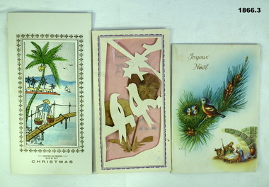
Card - CARDS XMAS VIETNAM, C. 1969 - 70
The cards were sent to Geoff Murray by Sister Augustine from the Baria Orphanage South Vietnam. On Geoff's 2nd tour of Vietnam with Survey Corp 15.10.69 to 15.10.70 he was a great supporter of the Orphanage with food and rations. Refer 594.2, 610.2P, 611.8 re Geoff and the Orphanage. His first tour was with 3 Cav Regt 27.11.67 to 22.10.68, refer 638P..1) Christmas card with scene of Vietnamese village. .2) New Year's card with paper cutout birds and pressed flowers. .3) Christmas card with painting of birds and nativity scene on cover and pop-up nativity scene.documents-cards, natural history specimens-botany, vietnam -
 Creswick Campus Historical Collection - University of Melbourne
Still Image, 1952
Subject: King Lake . 6 brown envelopes marked Run 3, 4, 7, 7a, 8, 9 containing c. 80 prints. 1 section of a topographical map marked State Aerial Survey. Stored in a brown cardboard file box marked King Lake Run No.3 - 9. (x9). Photos commissioned by Forests Commission Victoria.Aerial Photographs -
 Eltham District Historical Society Inc
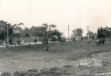
Photograph, Alistair Knox Park, Eltham, c.1970, 1970c
View from northwest corner showing survey pegs for trees and two ponds. Main Road has been duplicated. Bridge Street intersection showing the rock wall on the east side of the original Main Road (Maria Street). Burgoyne's Store and Eltham Uniting Church in distance at centre right and Our Lady Help of Christians at centre left.In February 1968 an unknown person took a series of photos from the Eltham Hotel at Pitt Street heading north along Main Road through the shopping centre to just north of Elsa Court covering the length of the section of Main Road which was duplicated shortly thereafter. Shows the condition and environment of the streesscape of Main Road, Eltham immediately prior to the duplication between Pitt Street and Elsa Court through the shopping centre. Also shows a number of shops and businesses that operated at that time.Black and white photographduplication, eltham, main road, bridge street, burgoyne's shop, eltham uniting church, our ladys church, maria street -
 Bendigo Military Museum
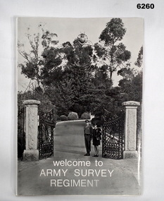
Booklet - Welcome to the Army Survey Regiment, Army Survey Regiment, Circa late 1970's
An information booklet provided to new arrivals at the Army Svy Regt. It contains information on daily routine, unit facilities and services, accommodation options, sports policy, Regimental Appointments, recreational facilities and places of interest around Bendigo. Cover photo of the gate entrance to the Army Survey Regiment on the cover. WO1 Ken and Cpl Heather Slater stand at the gate. A4 soft covered booklet, paper pages held together with "ARNOS" an Fastenerroyal australian survey corps, rasvy, fortuna, army survey regiment, army svy regt, asr -
 Marysville & District Historical Society
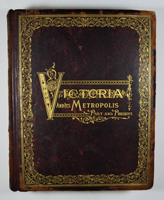
Book - Hardcover book, McCarron, Bird & Co, Victoria and its Metropolis-Past and Present-Volume 2, 1888
A history of the various colonies and districts of Victoria from the time of the discovery of Australia through until 1888.Hardback. Dark brown cover with the title in gold lettering. There is also a border in gold decorating the outer edge of the front cover. The spine is also decorated in gold along with the title and the volume number.non-fictionA history of the various colonies and districts of Victoria from the time of the discovery of Australia through until 1888.melbourne, victoria, pioneers, colonisation, history, fauna, flora, banking, finance, medicine, western district, south-western district, wimmera district, geelong district, ballarat district, avoca district, coliban district, campase district, loddon district, lower goulburn district, upper goulburn district, ovens district, north-east district, gippsland district, mornington district, westernport district, upper yarra district, evelyn district, bourke district -
 Bendigo Military Museum
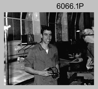
Photograph - Printer Technicians Operating Printing Presses at the Army Survey Regiment, c1980s
These nine photographs of Printer Technicians operating printing presses were probably taken circa 1980s in Lithographic Squadron at the Army Survey Regiment, Fortuna, Bendigo. c1980s. They are most likely operating the Komori, Planeta or Ultra-MAN-III offset printing presses. Although most photos except for photos .1P to .4P are not annotated, most personnel are positively identified..1) - Photo, black & white, c1980s, SPR Mark ‘Dogs’ Doherty, Lithographic Squadron .2) - Photo, black & white, c1980s, Paul Davis, Lithographic Squadron .3) - Photo, black & white, c1980s, L to R: unidentified, CPL Peter Breukel, Lithographic Squadron .4) - Photo, black & white, c1980s, SPR Colin Campbell, Lithographic Squadron .5) - Photo, black & white, c1980s, CPL Paul Davis, Lithographic Squadron .6) - Photo, black & white, c1980s, CPL Paul Davis, Lithographic SPR Mark ‘Dogs’ Doherty Squadron .7) - Photo, black & white, c1980s, L to R: WO2 Jeff Lynch, CPL Paul Davis, Lithographic Squadron .8) - Photo, black & white, c1980s, unidentified, Lithographic Squadron .9) - Photo, black & white, c1980s, CPL Josh De Groot, Lithographic Squadron .1P to .4P – personnel annotated .5P to .6P, .8P to .9P – no annotation .7P – no personnel annotated, ‘Last PNG JOG’ annotatedroyal australian survey corps, rasvy, army survey regiment, army svy regt, fortuna, asr, litho, printing -
 Forests Commission Retired Personnel Association (FCRPA)
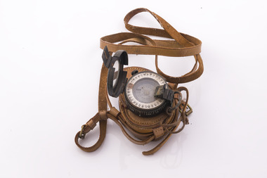
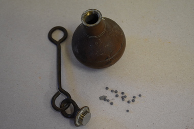
Prismatic Compass with leather case and strap, Ex Army 1940s
A prismatic compass is a common navigation and surveying instrument which was used extensively by the Forests Commission The compass most commonly used to run a traverse line. The compass calculates bearings of lines with respect to magnetic needle. A magnetic deviation correction was needed to convert the reading to a true bearing The compass could also determine angles between the traverse and waypoints (such as hilltop features). Commonly used for navigation. Largely replaced by modern GPS technology.Ex Army WW2 prismatic compass with leather case and strap. Rugged design and made of metal the internal compass plate floats on oil to help it stabilise The user lines up the direction of travel with the hair sightline in the fliptop cover and readings are taken through the viewfinder prism (hence the name).forest measurement, surveying -
 University of Melbourne, Burnley Campus Archives
Plan, Plan of Richmond Park, 1886-1948
(1) Black and white photographed copy of an original coloured plan. Plan of Richmond Park with Horticultural Society Gardens marked in. Includes additional land which became the Field Station. Stamp, "Neg. 18375 Department of Lands and Survey Photographed at the Central Plan Office 1/1 Plate 7.12.48". Original plan dated 19.11.86 showing land, "Permanently Preserved for the Gardens." (2) Also 2 photocopies, 1 reduced - possibly used in a publicationgardens, richmond, horticultural society of victoria -
 Phillip Island and District Historical Society Inc.
Photograph Album, Kodak, Phillip Island Cemetery, c 1990
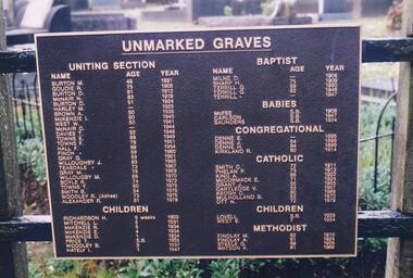
The Album was compiled by Nancy McHaffie late 1990's, with the assistance of Edith Jeffery's, with her book "Garden of Memories" and extensive knowledge of Phillip Island. The Cemetery lies back from the road and is surrounded by Manna Gums, rare Peppermint Gums, Blackwoods and other native trees. In all 25 acres of land were set aside as Crown Land in the land settlement of 1868. There are 6.2 acres of wetlands near the cemetery entrance.2 Photographs: 466-08 Notice of the Unmarked Graves. Although the land for the cemetery was granted in 1870, a survey was not made until 1903 hence the existence of unmarked graves. 466-09 A disastrous fire swept through the cemetery in 1943, destroying many structures around the graves - hence the rule "no wooden structures". the Hitching Posts were used for tying up hrses during a funeral service. They were erected in 1912 and now only two remain.phillip island cemetery, nancy mchaffie, edith jeffrey -
 City of Greater Bendigo - Civic Collection
Administrative record - Land Sales, A. J. Mullet Government Printer, 1927
This type of album was created by agents auctioning and selling land.Large portfolio style album with black cloth cover bound with three large metal pins. Blue marbled pastedown endpapers. Seventy nine pages, seventy five with Department of Lands and Survey maps attached. No index page. Maps have handwritten notes and markings throughout in pencil and pen. Covers the Counties of Bendigo, Rodney, Gladstone and Talbot and Parishes of Kerang, Salisbury, Mandurang and Tarnagulla. Includes a hand written note on William Wallace & Co letterhead. city of bendigo commerce -
Bendigo Historical Society Inc.
Document - MARKS COLLECTION: NEW CHUM LINE OF REEF MAP
Plan (copy) of New Chum Line of Reef . Plan has been copied in two sections. On top of plan 'Underground survey of mines Sandhurst, New Chum Line of Reef' , plan shows longitudinal and cross section views of the workings on the reef. Shaft No. 76 marked. Datum line on top indicates 750' above sea level, on bottom of plan, bottom of shaft 2022.24 below sill. Drawn by Arthur Everett, Mining Department, Melbourne, 1884.bendigo, mining, new chum line of reef -
 Bendigo Historical Society Inc.
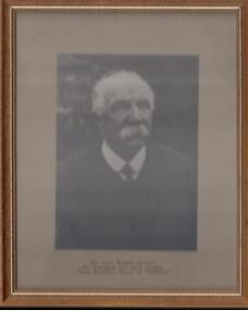
Photograph - FORTUNA COLLECTION: PHOTOGRAPH, 09/09/1990
Sepia photograph, head & shoulders, of Thomas Pearce in wood frame with painted gold inner edge. On a label underneath photo : The late Thomas Pearce who designed and hand forged Main Entrance Gates at 'Fortuna'. On a label attached to back of photograph: Presented to Commanding Oficer, Army Survey Regiment Lt-Col R. Van den Tol, by the Grand children of the late Thomas Pearce on the occasion of unveiling of Plaque to his memory. 9th September 1990 -
 Bendigo Historical Society Inc.
Document - STATE RIVERS AND WATER SUPPLY COMMISSION : CONSTITUTION AND FUNCTIONS
State Rivers and Water Supply Commission. Five page typed foolscap document, stapled, outlining the organisation's constitution and functions. The specific functions mentioned include Storage, Irrigation, Drainage - Flood Protection, Town Water Supply - Trust and Urban, Sewerage, Control, Crown's Rights, 1969 Groundwater Act, River Gauging’s, Survey and Research, Finance, Overseas Work, and Payroll (3500 employees). The document is undated, though some of the statistics given are from 1969.state infrastructure, water supply, coliban system, state rivers and water supply commission. coliban system. -
 Federation University Historical Collection
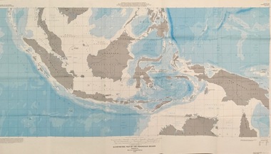
Map - Geological, U.S. Government Printing Office, Bathymetric Map of the Indonesian Region: Folio of the Indonesian Region Map I-875-A, 1974
Map was prepared on behalf of the Government of Indonesia, The United Nations Economic Commission for Asia and the Far East, the Agency for International Development and the U.S. Department of State in cooperation with the Geological Survey of Indonesia. The area covered shows the islands and seas from Latitude 12 degree North to 16 degrees South and Longitude 90 degrees to 148 degrees. Various water features are also named.Large map showing the Indonesian area - islands and seasLongitude and Latitude are shown. Major / Capitol cities indicated. Names of those responsible for the productionindonesia, united nations economic commission, department of state, geological survey, latitude, longitude, government of indonesia -
 Warrnambool and District Historical Society Inc.
Plumb bob, Early 20th century
A plumb bob or plummet is a weight suspended from a string or rod and used as a vertical reference line or plumb line. It is the vertical equivalent of the water level. It is used to ensure constructions are plumb or level. It has been in use since Egyptian times and is also used in surveying. It is still in use today. This plumb bob weighs 910 grams and was probably used in the building trade. This item is retained as an interesting example of a trade tool from the past.This is a brass weight with a bulbous-shaped body rounded on the bottom, a slender neck and an enclosed top. The top has a metal ring to which is attached a metal rod with a ring at the end. The item is a little stained.building accessories, history of warrnambool -
Federation University Historical Collection
Booklet - Document, Robert Ashley et al, 'The Lal Lal Iron Tramway', 1970
High on a series of terraces overlooking the Moorabool River stands the remains of the Lal Lal Blast Furnace, classified 'A' by the National trust (to be preserved at all costs). This was the location of Victoria's only pig iron industry. A series of tramways served the works, as a well surveyed narrow-gauge tramway connected the blast furnace with the Victorian Roailways' main line about 3.5 miles away. Light Railways, no 24, Summer 1970-71, 36 pages. This booklet considers the Lal Lal Iron Tramwaylal lal iron, lal lal blast furnace, tramways, railways, pig iron, ironstone quarry, industrial heritage -
Federation University Historical Collection
Booklet, Ballarat School of Mines, Student Magazine, Second Term, 1910
Table of Contents: Editorial, Open Night, Process in Ore Treatment at Kalgoorlie, Notes on Surveying, Artesian Wells, Concrete: Its use in mining, Description of the I. R. Process, "Old Boys" at Mt Morgan, News and Notes, Past Students, Correspondence, Answers to Correspondents, Handy to Know, Sporting Notes, Discovery of Chloroform, Say!, A Tragedy, The Berdan Pan, Editorial Notes. Orange coloured booklet of 28 pages.ballarat school of mines, students' magazine, king edward vii, m. w. bernewitz, angus a. gibson, r. ingram-moore, philpot f. brown, w. avery, e. prendergast, godfrey stephen hart, t. s. hart, l. westcott, a. r. booth, w. t. lakeland, lewis westcott, leo m. seward, reginald williamson, stanley white, clyde allan, charles laird, w. e. eyres, virgil tucker, h. hawkesworth, h. j. saw, h. meadows, fred g. brinsden, c. stephenson, fred treloar, j. peart, e. m. weston, dick galloway, h. b. bennetts, g. r. curry, will watson, don cameron, eric bieske, cliff garrard, lindsay d. cameron, phil brown, w. p. avery, j. foster, j. bickett, f. h. inglis, g. davenport, l. c. courbould, t. lennon, h. wilkins, g. h. reid, c. hesselmann, e. fraser, e. c. hurdsfield -
Ballarat Heritage Services
Document - Report, McDougall and Vines Conservation and Heritage Consultants, Sturt Street Gardens, Ballarat, Victoria Conservation and Landscape Management Plan, 2007, 07/2007
Ballarat's Sturt Street has its origins in W.S. Urquhart's survey of 1851. A generous reserve was allocated for the main streets of Ballarat, of which Sturt Street was the first. In the 1860s Sturt Street was planted with blue gums, with a dual carriageway and central median strip installed. Bandstands ere soone erected, including the Queen Alexandra Bandstand (1908) and the Titanic Memoria Bandsatnd (1915).PDF of a report on the Sturt Street Gardens, Ballarat.sturt street ballarat, conservation management plan, sturt street gardens, landscape management plan, statue, gardens, bandstands, infrastructure, city of ballarat report -
Unions Ballarat
Independent Report of the Victorian Industrial Relations Taskforce: Part 2 - Statistical Research on the Victorian Labour Market, Ian Watson et al, 08/2000
Commissioned by the Kennett government in 2000. The findings of this report intimate that deregulation of the labour market impacts adversely and inequitably upon workers who are already have unfavourable outcomes from the current system. This is volume 2 of a two volume report. Volume 1 (object B0446) is also held. Vol 1 - survey findings. Vol 2 - Analysis of labour force data.Relevant to history of modern industrial relations in Australia.Paperback. Front cover: background; white lettering.Front cover: title.btlc, ballarat trades hall, ballarat regional trades and labour council, victorian industrial relations taskforce, victorian state government, statistics, labour market - deregulation -
Unions Ballarat
Independent Report of the Victorian Industrial Relations Taskforce: Part 1 - Report and Recommendations, et al, 08/2000
Commissioned by the Kennett government in 2000. The findings of this report intimate that deregulation of the labour market impacts adversely and inequitably upon workers who are already have unfavourable outcomes from the current system. This is volume 1 of a two volume report. Volume 1 (object B0446) is also held. Vol 1 - survey findings. Vol 2 - Analysis of labour force data.Relevant to history of industrial relations in Australia.Paperback - brown cover, title in white lettering.btlc, ballarat trades hall, ballarat regional trades and labour council, victorian industrial relations taskforce, victorian state government, statistics, labour market - deregulation -
 Bendigo Military Museum
Album - Photographic Identification Guide (PIG) of the Gove Penisula (Sic) Peninsula, Army Topographic Support Establishment, May 1997
These photographs and a video were captured in May 1997 by Jeff Ruiz and Wayne Walsh from the Army Topographic Support Establishment (ATSE). The video taken onboard an aircraft has not been located at this time. A flight line diagram showing the path of the aircraft taking the video is enclosed in the album. The Army Topographic Support Establishment was created to perform some of the functions of the Army Survey Regiment.A Large Purple covered Album with gold dots containing maps, plans and coloured photographs of Gove Peninsula.royal australian survey corps, rasvy, fortuna, army survey regiment, army svy regt, asr, atse -
 Bendigo Military Museum
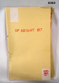
Administrative record - Royal Australian Survey Corps Report on Operation Aright 87 conducted by 1 Field Survey Squadron 1987, 1 Fd Svy Sqn, 26 Aug 1987
1 Fd Svy Sqn in conjunction with 2 Fd Svy Sqn conducted Operation Aright 87 in the Cape York Peninsula area over the period 8 May - 18 Jun 1987. The aim of the Survey Operation was to field verify the 70 x 1:50,000 map sheets which comprised the area of operations. This report details the activities conducted and the results achieved. Manilla Folder with title "OP ARIGHT 1987" containing a paper report of typed pages and diagrams bound together with an ARNOS fastener."OP ARIGHT 87" on front coverroyal australian survey corps, rasvy, fortuna, army survey regiment, army svy regt, asr -
Bendigo Historical Society Inc.
Document - Fortuna Bendigo, letter of re classification by the National Trust and History Brochure, 20/10/2008
The Fortuna Villa is an expansive Victorian mansion built entirely on the profits of Bendigo's lucrative gold reefs. Established by the wealthy Ballerstedt family in the 1860s, it was purchased and expanded in the 1870s by George Lansell, who was to become one of Australia's wealthiest men. Fortuna villa and gardens were once occupied and cared for by the Australia Army Survey Regiments since 1942 for over thirty years.Classification Report and Notes on the history of Fortuna from the National Trust to the Bendigo Council 20th October 2008; tourist brochure for Fortuna; it includes photographs and detailed history of George Lansell's involvement in the property and his mining history.history, national trust bendigo collection, bendigo, fortuna, george lansell, mining -
 Wodonga & District Historical Society Inc
Functional object - Seal - Police Office, Belvoir, c1854
This seal was used for official police and court documents by the Belvoir Police Office.The initial land survey for the city now known as Wodonga was first undertaken in 1852 by Thomas Wedge - Assistant Surveyor. The new township was called "Belvoir" and was proclaimed by that name in 1852 and again in 1861. The first sale of land in Belvoir was held at Wangaratta on April 28, 1854, when all the allotments surveyed by Thomas Wedge (excepting those set apart for reserves, government and public areas) were offered at auction. Following representations by the Postmaster General on June 23, 1869, the Governor in Council, on July 12, 1869, approved of its Aboriginal name "Wodonga" being restored. The seal was found at the Yackandandah Courthouse by the Circuit Judge, the late Mr. Jim Humphrey. As the Wodonga Historical Society was in recess at that time, the seal was held in trust by the North-East Historical Society in Wangaratta. It was donated to the Wodonga Historical Society in 1987.This item was the official seal of the Belvoir Police office from the beginning of the European settlement of the modern day city of Wodonga, then know as Belvoir. It is one of the earliest relics of that period of history, until its name was changed in 1869.Wood and metal seal bearing the official emblem of the Police Office Belvoir. It would have been used to apply a wax seal to official documents. The seal is mounted in a timber and glass case so that the imprint of the seal can be seen reflected in a mirror mounted in the base of the box.Around the edges of the seal "POLICE OFFICE / BELVOIR"belvoir police, official seal, history wodonga -
Federation University Historical Collection
Document - Document - Syllabus, Education Department, Victoria,Technical Schools, Syllabuses
Technical Schools Syllabuses produced by the Education Department of Victoria. Items cover the period between 1914 and 1948. They outline the requirements for various subjects, covering the following: .1: Sound and Light; .2: Course for Public Analysts, Day and Evening; .3: Sheet Metal Work; .4 Land, Engineering and Mine Surveying (1914); .5: Surveying (1921); .6: Physics (1924); 7: Iron, Steel and Engineering Alloys (1924); .8: Instrument Making(1924); .9: Elementary Science (1924); .10: Shorthand (1925); .11: Elementary Science- for Girls (1926); .12: Physic- Women's School (1928); .13: Typewriting (1929); .14: Painting and Decorating (1929); .15: Plumbing and Gasfitting (1929); .16: Plastering (1929); .17: Signwriting (1929); .18 Plumbing and Gasfitting (1937); .19: Course for Fibrous Plastering (1937); .20: Plumbing and Gasfitting (1938); .21: Course for Fitting and/or Turning and Machinist (1948). This is a 48 page booklet. 21 A5 sheets typedtechnical schools, syllabuses, victoria, education department, sound and light, public analysts, sheet metal work, land engineering and mine survey, surveying, physics, iron steel and engineering alloys, instrument making, elementary science, shorthand, elementary science for girls, physics women's schools, typewriting, painting and decorating, plumbing and gasfitting, plastering, signwriting, fibrous plastering, fitting and/or turning, machinist, 1914, 1921, 1924, 1925, 1926, 1928, 1929, 1937, 1938, 1949 -
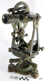 Flagstaff Hill Maritime Museum and Village
Theodolite, Troughton & Simms, Mid 19th Century
The theodolite was sold by T. Gaunt & Co. of Melbourne, a manufacturer, importer and retailer of a wide variety of goods including jewellery, clocks and watches, navigational and measuring instruments, dinnerware, glassware and ornaments. Thomas Gaunt photograph was included in an album of security identity portraits of members of the Victorian Court, Centennial International Exhibition, Melbourne, 1888. (See further details below.) History for Troughton & Simms: Edward Troughton & William Simms established a scientific instrument making business in London in 1826. Edward Troughton (1756-1835) had previously had his own scientific instrument business, inherited from his father. His achievement's included a transit telescope for Greenwich Observatory (1816) and the precision surveying instruments for the Ordnance Survey of Britain, Ireland and India. William Simms (1793-1860) had trained as a goldsmith and began to gain work dividing circles on fine astronomical instruments. When William Simms died in 1860, the business was taken over by his son James and nephew William. Troughton & Simms shop in Fleet Street became the hub of the finest scientific instrument made in London, in a period in which there was an expanding demand for precision instruments, for astronomy, surveying and precision measurement. They made instruments for Greenwich Observatory, for imperial surveys and exploring expeditions. When fire destroyed the Houses of Parliament in 1834, the firm was commissioned to create new standard lengths, this required 10 years of testing against the remaining old measurements. Troughton and Simms made several of the main instruments for Melbourne Observatory, including an 18 inch azimuth used of the Geodetic Survey, portable transit instrument (circa 1850), zenith sector (1860), a 4.5 inch equatorial telescope (1862), an 8 inch equatorial telescope (1874) spectroscope (1877) and an 8 inch transit instrument in (1884). While the firm had an excellent reputation for quality the company exasperated many of its customers with delays of years in delivering some instruments. History for Thomas Gaunt: Thomas Ambrose Gaunt (1829 – 1890) was a jeweller, clock maker, and manufacturer of scientific instruments, whose head office and showroom were at 337–339 Bourke Street, Melbourne, Victoria, Australia. Thomas Gaunt established Melbourne's leading watchmaking, optical and jewellery business during the second half of the 19th century. Gaunt arrived in Melbourne in 1852, and by 1858 had established his own business at 14 Little Bourke Street. Around 1869 he moved to new premises in Bourke Street on the corner of Royal Arcade, Gaunt's shop quickly became a Melbourne institution. Gaunt proudly advertised that he was 'The only watch manufacturer in the Australian colonies'. While many watches and clocks may have had Gaunt's name on the dial, few would have been made locally. Gaunt did make some watches for exhibitions, and perhaps a few expensive watches for wealthy individuals. Gaunt's received a telegraph signal from Melbourne Observatory each day to correct his main clock and used this signal to rate and repair ship's chronometers and good quality watches. Thomas Gaunt also developed a department that focused on scientific instrumentation, making thermometers and barometers (from imported glass tubes), telescopes, surveying instruments and microscopes. Significance: With the rapid urban expansion, one of the most important needs of the new colony was to survey and map the landscape of the Australian Colony’s interior. Theodolites, such as this one, made by Troughton and Simms, who were significant scientific instrument makers of the 19th century were instrumental to the colony's surveyors and would have played an important part in their everyday work. This transit theodolite remains of national significance due to its pioneering role in Australian science and its association with Australia's earliest surveyors and astronomers. It is also significant for its association with nineteenth-century surveying instruments and instrument makers. Theodolite, Vernier repetition theodolite with enclosed horizontal circle (of about 130 mm diameter). Vertical circle exposed and somewhat corroded (diameter about 115 mm). Plate level 20" per division. Altitude bubble 20" per division. Horizontal and vertical circle intervals 20". Original (blue/grey) paint. Altitude bubble setting screw disabled. Tribrach allows movement of theodolite by 15 mm inside tribrach (for centering).Inscribed on the inner mounting plate,“Specially made in England for T Gaunt & Co Melbourne” and inscribed a little lower “Troughton & Simms London”flagstaff hill, warrnambool, shipwrecked-coast, flagstaff-hill, flagstaff-hill-maritime-museum, maritime-museum, shipwreck-coast, flagstaff-hill-maritime-village, theodolite, t. gaunt & co, troughton & simms, scientific instrument, measuring instrument, surveyor's instrument -
 Eltham District Historical Society Inc
Photograph (Item) - Print, Michael Ridley, Untitled (Roycroft Bookshop, exterior), 1988
Roycroft Antiquarian Booksellers run by Lloyd Hollyoak and specialising in old, rare and out of print books was located at 1026 Main Road, Eltham next to present-day Flight Centre. In the early 1990s the store relocated to Kew and is now known as Abra Card Abra Roycroft. Michael Ridley 1988 Entrant No. 20 Ref: Series 34, Items 7, 8, 52-55 SHIRE OF ELTHAM COMMUNITY PHOTOGRAPHIC SURVEY Photography is an artform which many of us practice, sometimes purely for artistic pursuit, sometimes to record the people and events in our lives. In 1988, as part of a local Bicentennial project, the Shire of Eltham conducted the Eltham Community Photographic Survey. Up to 100 entries were to be selected by a panel of photographers for entry into the Eltham Photographic Survey Exhibition. Entries had to be submitted by May 13, 1988. Entrants whose images were selected for the exhibition were contacted and requested to further submit an entry form providing entrant’s name, area of residence, age, and proposed captions. These details were then used to produce labels for the exhibition mounts. Where negatives had not been supplied, these were requested to support the display of printed enlargements mounted on 10” x 8” cardboard. The mounted prints were made available post exhibition for sale at $8.50 each for colour prints and $7.00 for B&W prints. Residents in the Shire were invited to collect a free roll of film and take a photograph of what they either liked or did not like about the area. A total of 160 entrants submitted multiple entries for the exhibition. Of those selected for exhibition, entrants ranged in age from 9 to 70 years. All custom colour and black and white printing for the exhibition was completed by Wattle Studios of Eltham. The Eltham Photographic Survey was jointly auspiced by the Shire of Eltham and Wattle Studios, of 953 Main Road, Eltham. The project was greatly assisted by: • David McRitchie, Media Studies Lecturer Victoria College, Rusden Campus. • Ian and Annette Toohill of Wattle Studios • Tracy Naughton, Eltham Community Arts Officer • Neville Emerson Pty. Ltd. • Superior Press, Eltham • Kodak Australasia Pty. Ltd. • Agfa Gevaert Ltd. • Townsend Colourtech Pty. Ltd. • The Australian Bicentennial Authority • Eleanor Bowers, Secretary, Eltham Arts Council The exhibition was placed on display in the Woolworths Arcade, Eltham between Monday June 6th and Saturday June 11, 1988. It was also intended to hold the exhibition at a venue in the Shire’s North Riding from Monday, June 20 to Friday June 24. It was then displayed at the Were Street Theatre, Montmorency from Friday, June 24 to Thursday, July 7. Series 34: Eltham Community Photographic Survey 1988 - Prints & Documentation Series consists of 117 photographs of Shire scenes taken by members of the community. Items I - 41 are larger photographs mounted on card, which were exhibited. Items 42 - 117 are unmounted copies, alternative takes and other entries. Corresponding negatives contained in Series 35: Eltham Community Photographic Survey 1988 – Negatives which consists of 267 colour and B&W negatives and one colour slide of Shire scenes taken by members of the community. The negatives are arranged by the entrant number of the photographer. The Eltham Community Photographic Survey collection is significant to the local community as it was curated by the local community - ordinary people of all ages - representing what they liked and did not like in the area where they lived. It represents an unfiltered representation of the Shire of Eltham as it was in 1988. It also represents one of many projects as part of the national programme of events and celebrations to commemorate the bicentenary. It is a time capsule of life in the 1980s of this urban and rural municipality in Melbourne's north. Front: Entrant No. and name on printed label Rear: Entrant No., name and address on printed label; also 'Series 34' and the 'Item No.' in pencilshire of eltham archives, bicentennial project, eltham, eltham community photographic survey, eltham photographic survey exhibition, series 34, series 35, scan - 35mm negative, eltham shops, film - ilford fp4, main road, michael ridley, roycroft antiquarian booksellers