Showing 172027 items
matching will street
-
 Kew Historical Society Inc
Plan, Melbourne & Metropolitan Board of Works : Borough of Kew : Detail Plan No.1291, 1905
The Melbourne and Metropolitan Board of Works (MMBW) plans were produced from the 1890s to the 1950s. They were crucial to the design and development of Melbourne's sewerage and drainage system. The plans, at a scale of 40 feet to 1 inch (1:480), provide a detailed historical record of Melbourne streetscapes and environmental features. Each plan covers one or two street blocks (roughly six streets), showing details of buildings, including garden layouts and ownership boundaries, and features such as laneways, drains, bridges, parks, municipal boundaries and other prominent landmarks as they existed at the time each plan was produced. (Source: State Library of Victoria). This plan forms part of a large group of MMBW plans and maps that was donated to the Society by the Mr Poulter, City Engineer of the City of Kew in 1989. Within this collection, thirty-five hand-coloured plans, backed with linen, are of statewide significance as they include annotations that provide details of construction materials used in buildings in the first decade of the 20th century as well as additional information about land ownership and usage. The copies in the Public Record Office Victoria and the State Library of Victoria are monochrome versions which do not denote building materials so that the maps in this collection are invaluable and unique tools for researchers and heritage consultants. A number of the plans are not held in the collection of the State Library of Victoria so they have the additional attribute of rarity.Original survey plan, issued by the MMBW to a contractor with responsibility for constructing sewers in the area identified on the plan within the Borough of Kew. The plan was at some stage hand-coloured, possibly by the contractor, but more likely by officers working in the Engineering Department of the Borough and later Town, then City of Kew. The hand-coloured sections of buildings on the plan were used to denote masonry or brick constructions (pink), weatherboard constructions (yellow), and public buildings (grey). A detail plan of part of Studley Park bordered by the major streets of Hodgson Street, Stevenson Street and Studley Park Road. Included on the plan are a number of significant Studley Park mansions in existence at the beginning of the 20th century. The unnamed street shown in the middle of the plan is McEvoy Street. The most important house still extant is Campion House, formerly named Dalsraith [Dalswraith] and Glendalough, owned since the 1940s by the Society of Jesus. Campion House can be seen on the corner of Hodgson and Studley Park Road. Its stables at the rear of the block have now been incorporated into a contemporary residence. An interesting feature of the plan is the 1910 annotation by Ed Seitz, professional designing engineer. Is Seitz the contractor who modified the MMBW original?melbourne and metropolitan board of works, detail plans, mmbw 1291, cartography -
 Kew Historical Society Inc
Plan, Melbourne & Metropolitan Board of Works : Borough of Kew : Detail Plan No.1570, 1905
The Melbourne and Metropolitan Board of Works (MMBW) plans were produced from the 1890s to the 1950s. They were crucial to the design and development of Melbourne's sewerage and drainage system. The plans, at a scale of 40 feet to 1 inch (1:480), provide a detailed historical record of Melbourne streetscapes and environmental features. Each plan covers one or two street blocks (roughly six streets), showing details of buildings, including garden layouts and ownership boundaries, and features such as laneways, drains, bridges, parks, municipal boundaries and other prominent landmarks as they existed at the time each plan was produced. (Source: State Library of Victoria)This plan forms part of a large group of MMBW plans and maps that was donated to the Society by the Mr Poulter, City Engineer of the City of Kew in 1989. Within this collection, thirty-five hand-coloured plans, backed with linen, are of statewide significance as they include annotations that provide details of construction materials used in buildings in the first decade of the 20th century as well as additional information about land ownership and usage. The copies in the Public Record Office Victoria and the State Library of Victoria are monochrome versions which do not denote building materials so that the maps in this collection are invaluable and unique tools for researchers and heritage consultants. A number of the plans are not held in the collection of the State Library of Victoria so they have the additional attribute of rarity.Original survey plan, issued by the MMBW to a contractor with responsibility for constructing sewers in the area identified on the plan within the Borough of Kew. The plan was at some stage hand-coloured, possibly by the contractor, but more likely by officers working in the Engineering Department of the Borough and later Town, then City of Kew. The hand-coloured sections of buildings on the plan were used to denote masonry or brick constructions (pink), weatherboard constructions (yellow), and public buildings (grey). Plan No.1570 shows the layout of gardens and houses in Sackville Street, Davis Street, Wrixon Street, and Fitzwilliam Street in 1904. While Thomas Street is included on the map, at this stage no houses had been built. The plan identifies two named houses: ‘Fairview’ and ‘Kylemore’. Fairview is more fully delineated in Plan No.1563. Kylemore is one of the few houses in Kew designed by John Beswicke. The most notable owner of Kylemore was William Whitehead, who owned the house between 1895 and 1900. In 1894, Australian newspapers reported the marriage of Whitehead’s daughter to Dr. Gerald Eugene Cussen, the brother of Sir Leo Cussen, the Supreme Court Judge. The married couple was to live at ‘Wilton’ (now the Kew RSL) from 1911-15.melbourne and metropolitan board of works, detail plans, mmbw 1570, cartography -
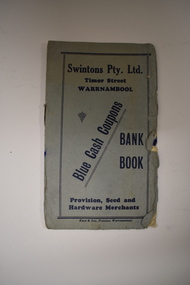 Warrnambool and District Historical Society Inc.
Leaflet, Kaye & Son, Printers, Swintons, Mid 20th century
This leaflet was a promotion tool of the Warrnambool business, Swintons Pty Ltd. It was used to insert stamps given by the firm when goods were purchased. When the pages were filled with 200 stamps the owner was given two shillings and sixpence in cash. It was a reward to the regular customer. William and Ann Swinton migrated to Australia in 1854 and for a decade William Swinton worked as a builder and carpenter in the Warrnambool area. In 1865 he opened a store in Timor Street, Warrnambool selling groceries, hardware, glassware and china. By 1888 the business was known as William Swinton and Sons. Branch stores were opened in Cudgee, Nullawarre, Wangoom, West Warrnambool and South Warrnambool. After William Swinton’s death, his son, Robert, became the first managing director of Swintons Pty Ltd. In 1934 the business split, with George Swinton and Sons selling furnishings, clothing and glassware and Swintons Pty Ltd selling groceries, seeds, produce and hardware. Today the Swinton family still operates a furniture and bedding store in Timor Street. This leaflet is of interest as an example of the advertising practices carried out by the firm of Swintons Pty Ltd, an important business in Warrnambool for many years. The current Swinton business in Timor Street, Warrnambool is the oldest family business in Warrnambool and, with the name Swinton associated with Timor Street businesses for 152years, it is amongst the oldest family businesses in Australia.This is a leaflet with a grey cover and four pages inside. The cover has dark blue printing and the pages have black printing and are ruled into 15 spaces. There are over 100 blue stamps stuck onto the ruled spaces. The cover is tattered at the edges and one stamp is loose.‘Swintons Pty Ltd Timor Street Warrnambool Provision, Seed and Hardware Merchants Blue Cash Coupons Bank Book’ swinton family businesses, warrnambool, history of warrnambool -
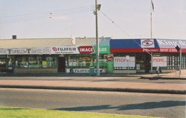 Lakes Entrance Historical Society
Photograph - Esplanade Lakes Entrance Victoria 2006, M Holding, 2006
businesses on the corner of Esplanade and Myers Street, Towels and Things and Lakes Photographics facing Esplanade, King and Heath estate agents on corner Lakes Entrance Victoria. Site orignally Mrs Zetic Bakers St Rosiers House. Carstairs Park Inn prior to demolitionColour photograph of businesses on the corner of Esplanade and Myers Street, Towels and Things and Lakes Photographics facing Esplanade, King and Heath estate agents on corner Lakes Entrance Victoriabusinesses, roads and streets, historic sites -
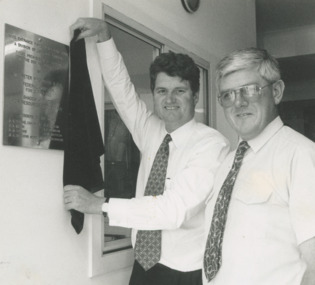 Lakes Entrance Historical Society
Photograph - plaque to mark the opening of the Fishermens Gear Store Carpenter Street Lakes Entrance Victoria, Lakes Post Newspaper, 1/02/1996 12:00:00 AM
Peter McGauren MHR unveiling a plaque to mark the opening of the Fishermens Gear Store with Peter Clark LEF Coop Board Chaiman Carpenter Street Lakes Entrance VictoriaBlack and white photograph showing Peter McGauren MHR unveiling a plaque to mark the opening of the Fishermens Gear Store with Peter Clark LEF Coop Board Chaiman Carpenter Street Lakes Entrance Victoriafishing industry, politicians, buildings -
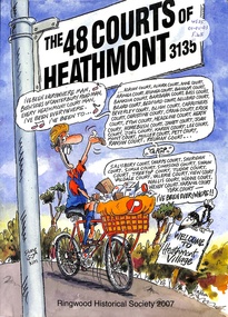 Ringwood and District Historical Society
Book, The 48 Courts of Heathmont 3135
Residential streets of Heathmont -
 Tatura Irrigation & Wartime Camps Museum
Photograph, 2001
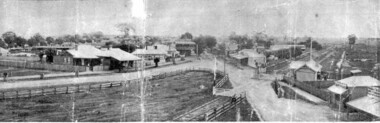
Hogan Street 1902hogan street, photograph, people -
 Stawell Historical Society Inc
Photograph, Pleasant Creek Special School, Stawell Technical School Patrick Street Nov 1975, Nov 1975
Photographs taken by teacher at Pleasant Creek Training Centre to help train students in living skills and becoming familiar with what shops sold. Part of socializing students for leaving the training centre.Patrick Street Building education, streetscape -
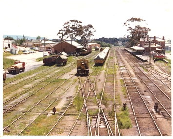 Stawell Historical Society Inc
Photograph, Pleasant Creek Special School, Stawell Railway Station, Goods Shed and Railway Station Nov 1975, Nov 1975
Photographs taken by teacher at Pleasant Creek Training Centre to help train students in living skills and becoming familiar with what shops sold. Part of socializing students for leaving the training centre.Napier Street Stawell education, railways, transport, streetscape -
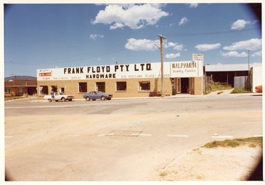 Stawell Historical Society Inc
Photograph, Pleasant Creek Special School, Frank Floyd Pty Ltd. Hardware Store, Wimmera Street Stawell Nov 1975, Nov 1975
Photographs taken by teacher at Pleasant Creek Training Centre to help train students in living skills and becoming familiar with what shops sold. Part of socializing students for leaving the training centre.Wimmera Street Stawell education, streetscape -
 Ballarat Heritage Services
Photograph - Photograph - Colour, Darwin Main Street, China Town, c1912, 1912
The main street of Darwindarwin, china town -
 University of Melbourne, Burnley Campus Archives
Photograph, James Leslie Provan, Burnley 1942 Album Page 2, 1942-1943
Swan Street entrance.swan street, entrance, burnley, 1942, j.l. provan -
 Bendigo Historical Society Inc.
Postcard - Alice McGregor Postcard Collection, 1900 - 1920
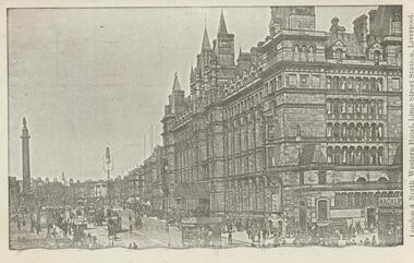
Alice McGREGOR Born: 1908; unknown parents. Possibly adopted by the Salter family? Electoral Roll 1936: Highland Terrace Kangaroo Flat. Alice Mary Salter and William Robert Salter living together; presumed to be sister and brother. William Robert Salter was killed in a MVA in Bendigo in 1937 aged 26. In Victoria in 1938, Alice Mary Salter married James Thomas McGregor (born Victoria 1917, died Victoria 1983, buried Fawkner Cemetery) Lived: 1968; 22 Wade Street Golden Square Alice McGregor Died: 1999 aged 91 at Anne Caudle Centre, Bendigo Buried: Kangaroo Flat Cemetery See additional research. Postcard Album of Alice McGregor contained 86 post cards.Postcard Album of Alice McGregor containing 86 postcards. See 1400 B&W photo of the London & North Western Hotel, Lime Street Station, Liverpool. A multi-story building overlooking a statue atop a column. Horse drawn vehicles and pedestrians in the street. Addressee - Miss Kelly, Norwood, Wills St, Bendigo, Australia Sender - M.I. Grendell (?) Dated 25 5.06, Liverpool postcard, collector, alice mcgregor -
 Federation University Historical Collection
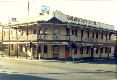
Photograph - Photograph - Colour, Golden City Hotel, Ballarat
The Golden City Hotel was established in 1856. It was known as GeeCees in 2015.Photograph of a double storey hotel in Sturt Street Ballarat. The hotel features a verandah with cast iron work. A red pillar box is evident on the corner of Sturt Street and Dawson Street.golden city hotel, geecees, letter box, pillar box -
 Kew Historical Society Inc
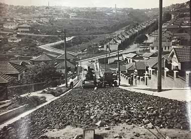
Photograph, City of Kew, Public Works, Road Construction, c. 1920s
An original photograph donated to the Kew Historical Society by the City's Engineering Department before the amalgamation of Kew into the City of Boroondara in 1994. While not all of the photographs are of Studley Park, Kew or East Kew, each photo provides a fine snapshot of the work of local government engineering departments of the period. They reveal they types of labour conducted, the techniques used and the equipment and machinery in the possession of the local government authority. Public works. A photograph of a suburban street under construction using a steamroller. The street was photographed to demonstrate the issues relating to grading. Neither the street nor the location has been identified. Inscription on reverse: "The construction of a roadway in a 1 in 3 1/2 grade. / The waggon is hauling the roller, by means of a cable attached to a pulley anchored at the top of the grade." engineering, city of kew (engineering department), road making construction -
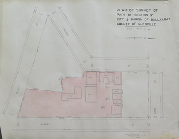 Federation University Historical Collection
Plan, Plan of Survey of Part of Section 9A City & Parish of Ballarat County of Grenville (Albert Street frontage), 1932
The M.B. John Trade Building was built on the Albert Street Frontage..1) Plan of SMB showing Albert, Grant, Lydiard and Dana streets, on paper with colored highlights undertaken by Ballarat School of Mines student George Murrowood in 1932 .2) Hand written page by George Murrowood, of technical description of land surveying Grade II 1932ballarat school of mines, surveying, george murrowood, albert street, alumni, m.b. john building, architectural plan -
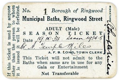 Ringwood and District Historical Society
Document, Packet: Municipal Baths, Borough of Ringwood- Cuttings, Certificates, Correspondence. 1928-1977
Miscellaneous documents related to the Ringwood Baths in Ringwood Street and the Ringwood Swimming Club.Packet includes: . 3742a- Season Ticket No 1 for the Municipal Baths, Ringwood Street, belonging to Cr A Temple Miles, dated 19.10.34 Season 1934-35. . 3742b- Typed document advertising the First Grand Aquatic Carnival at the Public Swimming Pool at dublin Road, Ringwood East. . 3742c- Invitation to Mr & Mrs R Pullin from the City of Ringwood for the Official Opening of Fred. Dwerryhouse Swimming Pool at Jubilee Park on 31st October, 1970. . 3742d, e, f- Early correspondence and reports on running of the Baths 1934 to 1937. . 3742g- Letter dated 19.9.1936 from the Ringwood Swimming Club to Ringwood Council requesting Clubrooms at the Baths. . 3742h- Two cards listing monthly items of interest dated 1925 to 1942. . 3742i- Ringwood Swimming and Life Saving Club Membership Cards for Kaye Maidment and William Maidment dated 9.11.58. . 3742j- Newspaper cuttings from 1928 to 1946. -
 Surrey Hills Historical Society Collection
Photograph, Grovedale Road Quarry in the 1920s - looking north, c1920
The quarry was part of John Butler Maling's property. He was one of the original settlers of the area and farmed the area between Weybridge Street and Whitehorse Road. Clay was quarried from part of this area and used to make the bricks used in the construction of his home, known as 'Ancyra'. This is still extant at the corner of Weybridge and James Streets. Maling grazed cows and used the quarry as a water source. He was the uncle of John Butler Maling, Mayor of Camberwell. He was married to Kate Conlon in 1882. They had 3 children: Silas Young, Alick and Zillah. Maling was born in c1829 in Shepreth, Cambridgeshire; he died in Surrey Hills on 9 October 1912 and is buried in Box Hill Cemetery - CE-*-0586. Mrs Kate Maling (born c1859 in Co Meath, Ireland) died at the property on 8 March 1921. She is buried in Brighton General Cemetery. Probate was valued at over 10,000 pounds and included other properties in Sandringham, Hawthorn and Macedon. At the time of her death the Surrey Hills property was described as being 23 cres with 2 brick houses, 1 cow, 2 heifers and 40 fowls or chickens. The property was subdivided after her death. The quarry was filled in after several drownings or near drownings and the land is now occupied by a park and playground maintained by the City of Boroondara. Beckett Park is sited on horizon to the left beyond the trees. This documents the landscape prior to close settlement and is material to early building and farming in the Surrey Hills area.Black and white photo of the quarry between Grovedale Road and James Street taken in the 1920s and looking north. In the foreground is an area of water with high banks dividing the horizontal centre. Beyond are paddocks and trees behind which is a row of at least 3 single-storey houses. Light poles can be seen along a distant street. There are many mature trees in the background. The houses and trees are positioned along Whitehorse Road in the vicinity of Westminster Street. Shadows indicate the photo was taken in early morning or evening.quarries, grovedale road, james street, surrey hills, balwyn, clay quarries, ancyra, kate conlon, kate maling, john butler maling, farming -
 Hume City Civic Collection
Photograph, c 1980s
The photograph although recently taken shows the original settled area in Sunbury, which included Goonawarra Vineyard and Macedon Street which was once the business centre of Sunbury township before the railway was established.A coloured photograph of Sunbury Township looking west from above Jacksons Creek and Goonawarra Winery. Macedon Street can be seen in the middle distance and Mt. Holden and Burke Hill are across the skyline.sunbury township, mt. holden, burke hill, francis, james goodall, barnier, john, jacksons creek, goonawarra winery, george evans collection -
Whitehorse Historical Society Inc.
Map, Municipality of Nunawading, c1950
Plan No 234, compiled and photo-lithographed at the Melbourne and Metropolitan Board of Works under the direction of G.R. McGowan, Chief Surveyor.Plan No 234, compiled and photo-lithographed at the Melbourne and Metropolitan Board of Works under the direction of G.R. McGowan, Chief Surveyor. Covers the area each Side of Canterbury Road from Orchard Grove to Vernon Street. Includes detail of creeks.Plan No 234, compiled and photo-lithographed at the Melbourne and Metropolitan Board of Works under the direction of G.R. McGowan, Chief Surveyor. blackburn south, gardiners creek, blackburn, blackburn creeklands -
 Port Fairy Historical Society Museum and Archives
Tool - Calendar
This item was bought by Lynda Tieman for the Port Fairy Historical Society. It represents a time in in Port Fairy when there were several butchers in the town and competition for customers was fierce. Norman Collins butchers was situated in Sackville Street where a dress shop now occupies the site.An advertising piece that places Norman Collins as butcher in 47 Sackville Street and a rare example of this type of advertising.Bamboo, advertising,give away calendar with green ribbon hanger for Port Fairy butcher (calendar removed). Printed with rural scene of ducks and hunting dogs. Bamboo slats are joined by thread and the ribbon is attached to the top of the calendar for hanging. Calendar itself has been removed.With Compliments from Norman Collins Your Quality Butcher 47 Sackville Street, Port Fairy, Phone 56 For Friendly Service and Free Deliverybutcher, advertising, business, collins, sackville street, norman collins, calendar -
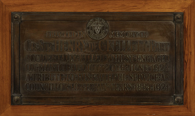 Kew Historical Society Inc
Plaque - Cr. Sir Henry de C. Kellett Bart, 1924
The plaque to Henry Kellett was originally mounted in the vestibule of the Kew Town Hall in Walpole StreetThe plaque was once part of the Municipal Collection of the former City of Kew and was presented to the Kew Historical Society before the move from the Walpole Street (Kew) Town Hall to new Civic offices in Charles Street in 1971.Bronze funeral plaque commemorating the life and death of Sir Henry de Castres Kellett, who was killed in a traffic accident in 1924. The plaque bears an extensive dedication and is mounted on a wooden mount that was previously attached to a wall in the Walpole Street [Kew] Town Hall ."City of Kew Victoria [logo] / Erected in Memory of / Cr. Sir Henry de C. Kellett Bart. / Accidentally Killed Whilst Engaged / On Municipal Duty 20th June 1924 / A Tribute to His Faithful Service as / Councillor for Forty Years 19884-1924"sir henry de castres kellett, mayors of kew (vic), councillors of kew (vic) -
 Glenelg Shire Council Cultural Collection
Photograph - Photograph - ANZ Bank, Portland, n.d
State Library of South Australia.Black and white photographic reproduction of earlier photograph. Depicting 2-storey bluestone building on a corner with door in left side, framed by double columns. Lamp on street corner and three figures (children ?) leaning against iron rail fence set in bluestone base.Front: A.N.Z. (Formerly Union) Bank. Cnr Percy & Julia Streets (typed label, top centre). Back: B21766/98 (pencil, upper left). State Library of South Australia Photographic Section. Order No. A16493 (stamp, centre).anz bank, commerce, banking, portland, bluestone building -
 Linton and District Historical Society Inc
Photograph, Murrell's Newsagency, Sussex Street, Linton, circa 1940
William Murrell ran a newspaper shop on the west side of Sussex Street until 1932, when he moved his business to a site formerly occupied by Dan Cornish (who ran it as a shoe shop). After William Murrell died the newsagency was run for many years by his daughter Carrie Murrell.Black and white photograph which shows buildings along the east side of Sussex Street, including Murrell's newsagency, the fire brigade building, and another shop or dwelling.murrell's newsagency, linton fire brigade building, buildings, shops, sussex street linton -
 City of Kingston
Pamphlet - Colour, Roy Dunn Pty. Ltd, Central Corner Estate Moorabbin and Highett, c. 1923
Sales plan for land in the suburbs of Highett and Moorabbin, bordered by Point Nepean Road and Wickham Road East incorporating William StreetThe developing urban area of Highett and Moorabbin within the City of Kingston. This land sale pamphlet illustrates the subdivision of land within the municipality and the changing demographic of the district as new houses are constructed close to infrastructure.Colour pamphlet advertising for private sale land in the Central Corner Estate in Moorabbin and Highett. Incorporates a map of the estate bordered by Point Nepean Road and Wickham Road East, with subdivisions also available on both sides of William Street. Handwritten in blue pencil on subdivision plan: a tick is drawn on subdivisions 2-18 Handwritten in blue pencil on subdivision 6: a box with an x inside Handwritten in blue pencil on subdivisions 10 and 12: S Handwritten in black ink on front page: [indecipherable] / McKittricks Handwritten in grey pencil on rear page: McKilhick / Nepean Rd Handwritten in grey pencil on rear page upside down: 160000 / 15 8300 [crossed out] land sales, estate, highett, moorabbin -
Port Melbourne Historical & Preservation Society
Photograph - 135 & 137 Evans Street (Raglan Street Housing Commission flats), Port Melbourne, Meredith Turnbull, Dec 1996
Meredith Turnbull photographed this series in 1996 to record the rapidly changing streetscape, which had already had a number of old houses replaced by concrete two-storey structures under the State government's urban consolidation policyFrom a series of 70 colour photos recording all buildings in Evans Street from Graham Street overpass to Ingles Street, as photographed from the railway reservation, by Meredith Turnbull in December 1996 - - number 135, 137- Raglan Street Housing Commission flatsHouse numbers noted on backbuilt environment - domestic, built environment - public housing, meredith turnbull -
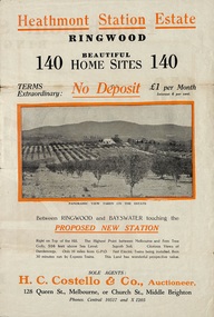 Ringwood and District Historical Society
Flyer, Land Sale Brochure, Heathmont Station Estate, Ringwood, Vic. - circa 1925
Extract of "Herald" 2/2/22: The intention of the Railway Commissioners is to electrify the line to the Gully as soon as convenient, and with greater frequency of service many persons settled, and settling, in the district will be benefited. There is a scheme which may be launched that will allow for an express service of fast trains to the Gully. The commissioners are alive to the necessity for assisting to settle the picturesque districts between Box Hill and Gembrook.Bi-fold advertisement for sale of retail and residential sites, including panoramic and other photographs, map, and summary of subdivision features and local facilities. Subdivision includes Canterbury Road, Station Street (later Wainui Avenue), Lisgoold Street, Viviani Crescent, and Balfour Avenue. Agent - H.C. Costello & Co., Auctioneer, 128 Queen Street, Melbourne, or Church Street, Middle Brighton. Phones: Central 10517 and X1205. -
 Warrnambool and District Historical Society Inc.
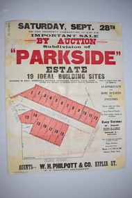
Work on paper - Original Document, H J Paynter, Advertisement "Parkside"Estate subdivision, Circa 1935
This sheet denotes an auction of land which is situated close to Albert Park on the northern part of Warrnambool. The area is complete now with homes which are a mixture of brick and concrete faced houses. The agent W H Philpott was operating in Warrnambool from the 1930's though to 1950'sThis item has local interest and significance as it records the sale of Warrnambool land.Large white paper sheet with black and red text. The auction details are at the top and down the righthand side with a map of the available blocks are coloured red and outlined in black.Parkside estate, W H Philpott & Co Kepler St , R V Philpott auctioneer,Solicitors J S Tait & son. Cramer Street, Nelson Street McConnell Street.warrnambool, mcconnell street warrnambool -
Clunes Museum
Financial record - ACCOUNT BOOK
ANCIENT BROWN COVERED ACCOUNT BOOK - BELONGED TO CLARA HOLMAN 1897HANDWRITTEN CLARA HOLMAN, FRASER STREET, CLUNES X 3 J. HOLMAN FRASER STREET, CLUNES. 1897.accounting record, financial record -
 Kew Historical Society Inc
Plan, Melbourne & Metropolitan Board of Works : Borough of Kew : Detail Plan No.1585, 1904
The Melbourne and Metropolitan Board of Works (MMBW) plans were produced from the 1890s to the 1950s. They were crucial to the design and development of Melbourne's sewerage and drainage system. The plans, at a scale of 40 feet to 1 inch (1:480), provide a detailed historical record of Melbourne streetscapes and environmental features. Each plan covers one or two street blocks (roughly six streets), showing details of buildings, including garden layouts and ownership boundaries, and features such as laneways, drains, bridges, parks, municipal boundaries and other prominent landmarks as they existed at the time each plan was produced. (Source: State Library of Victoria)This plan forms part of a large group of MMBW plans and maps that was donated to the Society by the Mr Poulter, City Engineer of the City of Kew in 1989. Within this collection, thirty-five hand-coloured plans, backed with linen, are of statewide significance as they include annotations that provide details of construction materials used in buildings in the first decade of the 20th century as well as additional information about land ownership and usage. The copies in the Public Record Office Victoria and the State Library of Victoria are monochrome versions which do not denote building materials so that the maps in this collection are invaluable and unique tools for researchers and heritage consultants. A number of the plans are not held in the collection of the State Library of Victoria so they have the additional attribute of rarity.Original survey plan, issued by the MMBW to a contractor with responsibility for constructing sewers in the area identified on the plan within the Borough of Kew. The plan was at some stage hand-coloured, possibly by the contractor, but more likely by officers working in the Engineering Department of the Borough and later Town, then City of Kew. The hand-coloured sections of buildings on the plan were used to denote masonry or brick constructions (pink), weatherboard constructions (yellow), and public buildings (grey). This plan, which covers parts of High Street, Pakington Street and Derby Street is dominated by two historic Kew mansions: ‘Konetta’ and ‘Ramornie’. Ramornie was constructed in 1890 for James Maitland Campbell, three times Mayor of Kew. Sold in 1940, it became a boarding house known as ‘The Towers’. Now a private residence again, it has only one of its three balconies remaining. The location of the missing two balconies can be seen on the plan. In 1903, the grounds of Ramornie included a large tennis court fronting Pakington Street. The rear of the property is shown as extending to Cobden Street. One of Kew’s oldest hotels, the Prospect Hill Hotel on the corner of High and Cobden Street was established in 1858. The outline of the hotel shown on the plan represents the second building on the site. During the 19th century it was often used for electoral meetings. The Prospect Hill Hotel was to be redeveloped again in 1928, by the local architect Robert McIntyre. Since the 1980s, the hotel has been a live music venue, the home of the Melbourne Jazz Club, a restaurant and a liquor outlet.melbourne and metropolitan board of works, detail plans, maps - borough of kew, mmbw 1585, cartography