Showing 2406 items
matching establishments
-
 Kiewa Valley Historical Society
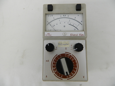
Meter Multi General Purpose, circa mid to late 1900's
This general purpose Multi-meter was manufactured after 1950 and used by the SEC Vic (Kiewa Hydro Electricity Scheme) from that date until late 1900's. It was used to measure very small voltages associated with the operation of the various Hydro Generators. The readings were able to be shown by the resistor in use in the current circuit. During this time period, high quality testing instruments were either sourced from Europe or England. This particular meter was manufactured in the Netherlands. This type of "old" analogue meter was replaced by digital meters whose electronic components are a fraction of the size of the older analogue ones.This analog General Purpose multi-meter is quite a large (for handheld mobile) apparatus which permits the easy monitoring of electrical variations within the large SEC Victoria Hydro Scheme's electrical generators. These generators are powered by the hydro force of "stored" water at a higher altitude. The establishment of both the NSW and Victorian Hydro schemes was achieved from the mid 1900's to the 1960's. At this point in time the need for additional power sources to quench both an industrial and domestic demand for electricity was purely an economic and not and environmental (carbon reduction) factor. This hydro scheme was instigated by "the Government of the day" as a bold move and was the major force of the World War II refugee and "technical" workforce inclusion of skilled and unskilled migration into the Australian environment. Although this mass "invasion" of workers with families was thought of in some circles as intrusive, the expansion of population post war years and its integration into the Australian rural sector, produced the multi- lingual multi-cultural diversity of later years.This General Purpose Multimeter is an analogue meter i.e. it has a needle arm that moves across a scale of divisions. This is a large(hand held) device due to the mechanical movement system within and the large size of its electronic components of its circuitry.There are two black bake-lite push buttons operating the wire inserts Positive/negative leads at the top. The meter (protected with a glass window) has clearly marked graduations (top - volts, bottom amperes). Below this are two bake-lite dials (left "potentiometer the right one measuring range selector). Below this is a "dial" switch to input the desired resistance measuring range "V" Front "H&B ELIMA" and to the right Elavi 15n. 0n the front side is a label "STATE ELECTRICITY COMMISSION OF VICTORIA TRANSMISSION DEPT E.C.No." On the bottom of the base is a stenciled layout of the battery "layout" including the fuse . The information notice is presented in five languages starting with German, English,French, Italian, Spanish and Dutchsec vic kiewa hydro scheme, alternate energy supplies, alpine population growth -
 Kiewa Valley Historical Society
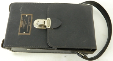
Case for G.P. Multimeter, Circa 1950
This leather case holder for a general purpose Multi-meter( KVHS 0307 (A)) was manufactured after 1950 and used by the SEC Vic (Kiewa Hydro Electricity Scheme) from that date until late 1900's. It was used to measure very small voltages associated with the operation of the various Hydro Generators. The readings were able to be shown by the resistor in use in the current circuit. During this time period, high quality testing instruments were either sourced from Europe or England. This particular carry case was manufactured in the Netherlands. This carry case for an analog General Purpose multi-meter which is quite a large (for a handheld mobile) apparatus.The bag however permits the easy monitoring of electrical variations within the large SEC Victoria Hydro Scheme's electrical generators. These generators are powered by the hydro force of "stored" water at a higher altitude. The establishment of both the NSW and Victorian Hydro schemes was achieved from the mid 1900's to the 1960's. At this point in time the need for additional power sources to quench both an industrial and domestic demand for electricity was purely an economic and not and environmental (carbon reduction) factor. This hydro scheme was instigated by "the Government of the day" as a bold move and was the major force of the World War II refugee and "technical" workforce inclusion of skilled and unskilled migration into the Australian environment. Although this mass "invasion" of workers with families was thought of in some circles as intrusive, the expansion of population post war years and its integration into the Australian rural sector, produced the multi- lingual multi-cultural diversity of later years.This leather case is to provide protection for this mobile G.P. Multimeter, therefore it is made from thick leather. It has a carrying strap from a thick "D" chromed link. This link is fastened to the main cover by a looped leather strip with a black coloured rivet. All the fasteners are either chrome or black coloured rivets. The front, which when opened back exposes fully the inside of the case. It is clip fastened to the lower section of the front piece which also can be pushed back allowing the meter to be removed from the frontal position. There is a strip retaining strap slightly higher from the mid point. This is fasted by a black press stud. There are two "L" shaped tin protrusions allowing the meter to slide only down the case until it rests on these shelves. This provides for an empty space for minimal storage,.On the front bottom and below the clasp is a tag "STATE ELECTRICITY COMMISSION OF VICTORIA TRANSMISSION DEPT."sec vic kiewa hydro scheme, alternate energy supplies, alpine population growth -
 Kiewa Valley Historical Society
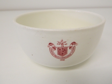
Bowl Ceramic, circa mid to late 1900's
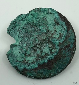
This bowl was used by the State Electricity Commission of Victoria in their mess rooms for their workers during the construction of the Kiewa Hydro Electric Scheme. The imprint of the year "1921" was to identify the year that the SECV was formed which relieved the private VHEC (Victorian Hydro-Electric Company). As the scheme was of such a huge scope, isolated and time consuming nature, the feeding of its workers was quite demanding of cutlery and crockery. The use of sturdy English cups and saucers was essential. The period of construction and the isolation of the Kiewa Valley area placed heavy demand for "solid" crockery that could wear abusive handling. This period in time was one when crockery, whether for domestic or commercial use, was imported from "mother" England. This scenario was more so for governmental bodies such as rail, jails and electricity providers than domestic users. The influx of cheaper Asian crockery had not yet begun.This type of crockery item was used by the thousands of SEC Victorian staff and construction workers involved in the building of the Kiewa Hydro Electricity Scheme, over the extensive period (1938 to 1961). This was a period when Government bodies and other semi- government organisations were still tied to the "establishments" of "mother" England. It was a period in Australia's development when the Asian influence was very weak and the established ties to England and Europe was still very strong. The majority of heavy equipment and machinery was either made in England or Europe. Local/European expertise in dam construction and water management in alpine terrain came from migrants and specialist recruited from England and Europe. The quality of workmanship from big steel manufacturing plants in England and Europe could not be matched from anywhere else in the developed world.This item is a white ceramic State Electricity Commission of Victoria bowl. It is made in England and is of strong and durable ceramic. The 5mm thickness of the ceramic suggests this bowl (cereal/soup) belongs to a commercial kitchen environment and not domestic. The indent bottom of the bowl is 5mm deep with a side curvature ratio of 2:5. The ceramic is glazed to a commercial standard (worker's mess). See also KVHS 0128 (B to D) for other ceramic crockery. The seal of the State Electricity Commission of Victoria is imprinted on the top outside rim within a curved scroll and a raised fist with electrical "charges" extending out.. Snuggled within the borders of the scroll is a banner with the five stars of the Southern Cross . On the underside "Vitrified sold by Cafe & Hotel Supplies Pty Ltd Dunn Bennett & Co. Ltd. Burslem Made in England"ceramic crockery, plate, secv, state electricity commission of victoria, crockery, mt beauty chalet, bogong mess hall -
 4th/19th Prince of Wales's Light Horse Regiment Unit History Room
Specifications, Specifications Army (Aust) 5368 and 368, (estimated); abt 1969-1980
Manufacturing drawings. Specifications for Australian Army metal badges and insignia in two lever arch foolscap files. The drawings are appendices to Specifications 5368 and 368 insignia, badges, specification 5368, manufacturing drawings, defence contracts -
 Kiewa Valley Historical Society
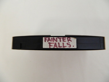
Video - Fainter Falls, Fainter Falls, 2003 - 2008
Visual workings and development of the Fainter Falls Trail completed in 2008. The trail was originally accessible via a fire fighting access trail. The fire in the summer of 2003 highlighted the beauty of the area and provided the residents of the Kiewa Valley with the opportunity to consider the redevelopment of the trail. Work to establish a 700 metre grade 2 walking trail with a 50 metre grade 3 extension trail to the Falls began in 2005. It also includes 3 observation decks, a bridge over a creek crossing, car parking and interpretive signage.This video recording is a visual recording of the process of the establishment of the Fainter Falls Walking Trail giving an insight into the process, the work, tools and materials used for such work from 2003 to 2008. It also shows the vegetation in the area and the amount of water flowing at the time.White cardboard cover with black plastic video labelled "Fainter Falls" on outer edge."Fainter Falls"fainter falls. bogong. walking trail. fire track. national parks of victoria -
4th/19th Prince of Wales's Light Horse Regiment Unit History Room
Booklet, Defence Printing Establishment, Training Command Officer's Aide-Memoire (TCOAM) 1976, 1976
A soft covered booklet to provide Training Command units with a common, comprehensive detail of doctrine for training purposesbooklet, training doctrine -
4th/19th Prince of Wales's Light Horse Regiment Unit History Room
Booklet, Defence Printing Establishment, Air Photo Reading (All Arms) 1973, 1973
A soft covered booklet providing the bases for training officers and NCOs in air photo readingair photo reading -
4th/19th Prince of Wales's Light Horse Regiment Unit History Room
Book, User Handbook (Provisional) Wireless Station C13/C13 in Truck 1 ton
Soft covered book detailing a general description, operation. servicing and installation of Wireless Station C13/C13 in Truck 1 Ton GS 4x4 Mk 1 or Mk 2 Austin K9SRDE Handbook No 999 (Prov)radio c13, handbook -
4th/19th Prince of Wales's Light Horse Regiment Unit History Room
Book, Defence Printing Establishment, Technical Manual User Handbook Radio Set PRC-F1 & F3 & GRC-F2, 1975
Handbook for equipment previously used by the RegimentHard covered book detailing general description, operating instructions and operator servicing of Radio sets PRC-F1 (2-12 MHz), PRC-F3 and GRC-F27610-66-086-8347handbooks, radio equipment, -
4th/19th Prince of Wales's Light Horse Regiment Unit History Room
Book, Ministry of Supply at Signals Research & Development Establishment, User Handbook for Wireless Sender C11, August 1957
Handbook for equipment previously used by the RegimentSoft covered book detailing a general description, operation and user servicing of the Wireless Set C11WO Code No 12052handbook, radio, wireless c11 -
4th/19th Prince of Wales's Light Horse Regiment Unit History Room
Book, Defence Printing Establishment, Vehicle Operating Instructions (Reprint 1973 Incorporating Amdt No1), 1973
Instructions for operation of unit vehiclesHard cover loose leaf book, about the administration, control and servicing of A, B and C vehicles and the responsibilities of formation commanders and commanding officers for vehicle operation and servicing7610-66-024-4122, Restriction notice, Badge of Commonwealth of Australiainstructions vehicle operation -
 Warrnambool and District Historical Society Inc.
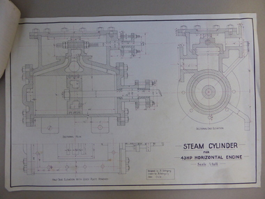
Document, Steam Cylinder Horizontal Engin, 1919
This drawing was produced by Ron Uebergang in 1919 at the Warrnambool Technical School. Members of the Uebergang families have been in the Warrnambool/Allansford area since the early 1850s. Ronald Uebergang (1903-1971) was born in Warrnambool, the son of Ernest Uebergang and Mary Watson. He lived at the family property, Hopkins Hill, and went to Allansford State School and Warrnambool Technical School. He was mechanically-minded, fond of music and dancing and a keen photographer. He married Myra Hall and they ran a dairy farm at Hopkins Hill and later went in for grazing beef cattle. Warrnambool Technical School was established in 1913, firstly at a Timor Street site and later at Caramut Road. Today it is called Brauer College. This drawing is of considerable interest as it was produced by Ron Uebergang. Members of the Uebergang families have been prominent in the Warrnambool/Allansford area since the early days of the district’s establishment. It is also important as a good example of the type of work produced by students from Warrnambool Technical School in its early years. This is a1919 drawing of a Steam Cylinder for a 45 HP Horizontal Engine. The drawing is half the full size of the cylinder. The drawing is on a white card with the sketches done in black and red ink. The card has a heavy black margin around the edges drawn in black ink. The drawing shows a Sectional Plan and a Half Side Elevation with the Cover Plate Removed. The card has the signature of Ron Uebergang. Attached by a metal clip to the card are four pages of measurements and plans of the steam cylinder. These are in black and red ink. Three of these pages have become partly detached. ‘Designed by R. Uebergang’ ‘Drawn by R. Uebergang’ ‘Date 1/12/19’ ronald uebergang, warrnambool technical school, history of allansford, history of warrnambool -
 Warrnambool and District Historical Society Inc.
Book, Divine Conduct or the Mystery of Providence, Early to mid 19th century
This is a book, ‘Divine Conduct or the Mystery of Providence’ originally written by the Rev. John Flavel in 1677. This is a later edition with no date listed but it is presumed it was re-published in the 19th century. The book was given to Janet McGhie in 1849, the first anniversary of the Warrnambool Sunday School, just 14 months after the first European settlers arrived in the new settlement of Warrnambool. The first Sunday School in Warrnambool was located in McDowell’s Store and run by Thomas Denney and Richard Osburne. The latter in 1851 commenced Warrnambool’s first newspaper, the Warrnambol Examiner and in 1887 published an important history of Warrnambool. Janet Garden McGhie was the daughter of Matthew and Isabella McGhie who were pioneer settlers in Warrnambool. Janet McGhie married Alfred Coulstock at the age of 17 and died in Warrnambool in 1918 at the age of 80. She was aged 11 when she received this book and one wonders what she made of the ponderous text. This book is very precious as one of the few mementos we have of the very early days of Warrnambool’s settlement. It gives us a date for the establishment of the first Sunday School and the name of one of the award winners. It is also an interesting example of the pious and ponderous writings that young children were expected to read in the mid 19th century. It is presumed that at that time there would not have been a great choice of reading material available in Warrnambool to give to childrenThis is a hard cover book of 252 pages. The dark green cover has gold lettering on the spine which is almost obliterated. The cover is partly detached from its binding and is much stained and blotched. There is an inscription on the inside front cover in black ink and a red stamp of the Warrnambool & District Historical Society on the first page. There are some indecipherable pencil markings on this first page and the last page.‘Janet McGhee (or McGhie), 1st Anniversary Warrnambool Sunday School, Decr 3rd 1849’janet mcghie, warrnambool sunday school -
 Warrnambool and District Historical Society Inc.
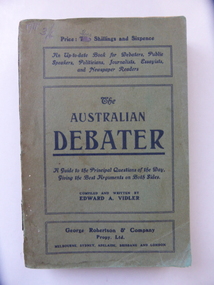
Book, The Australian Debate, Early 20th century
This book has been written by Edward Vidler (1863-1942), a publisher, editor, writer and journalist. He was born in England and was in Geelong in the 1880s where he produced a commemorative volume on that city. He was living in Warrnambool in the early years of the 20th century and was the Secretary of the Warrnambool and District Progress League and the Warrnambool Chamber of Commerce and Industry. He later lived in Melbourne where he edited magazines and published his own and other writings. He was especially interested in the promotion of the arts and was a keen naturalist. He was a foundation member of the group that established the Maranoa Native Gardens in Balwyn, Melbourne. The writer of this book, Edward Vidler, was important in the history of Warrnambool for two main reasons:- 1. In 1907 he initiated and organized the establishment of the Warrnambool Pioneer Honour Board featuring portraits of 204 pioneer men. This board still exists. 2. In 1907 he produced a publication called ‘Warrnambool Past and Present – Sixty Years of Progress’. It celebrated the 60th anniversary of the founding of Warrnambool and contained 88 pages, 120 illustrations and photographs and many advertisements. The publication is noted for its historical accuracy, the way it complements and adds to Richard Osburne’s 1887 history of Warrnambool and its presentation of historical material that may otherwise have been lost. Both of Vidler’s initiatives described above are of the utmost importance in Warrnambool’s history. This is a soft cover book of 270 pages. The cover is green with black printed material on the covers and the spine. The book has a Preface, 24 chapters of text and a Bibliography. There are advertisements for other books on the last page and the back cover. The cover is stained and faded and partly torn in places and some of the inside pages are stained. The Australian Debateredward vidler, history of warrnambool -
 Warrnambool and District Historical Society Inc.
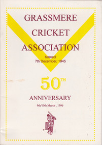
Booklet, Peter Doherty, Grassmere Cricket Association, 1995
Fifty year history of the Grassmere Cricket AssociationThis is a small paper back book with a cream-coloured cover with yellow and brown printing. The pages are unnumbered but there are 48 pages containing printed material, copies of photographs and other illustrated material. non-fictionFifty year history of the Grassmere Cricket Associationwarrnambool, grassmere cricket association, cricket, bushfield cricket club, wangoom cricket club, winslow cricket club, woolsthorpe cricket club, purnim cricket club, mailors flat cricket club, woodford cricket club, hawkesdale cricket club, orford cricket club, yambuk cricket club, killarney cricket club -
 Warrnambool and District Historical Society Inc.
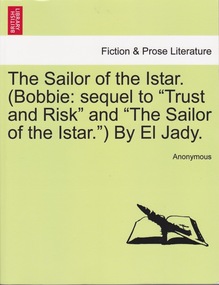
Book, Lillian Jane Duncan (nom de plum El Jady), The Sailor of the Istar, 1893
Novel written by El Ja Dy (nom de plume for Lillian Jane Duncan)Green paperback with white band with black text fictionNovel written by El Ja Dy (nom de plume for Lillian Jane Duncan) warrnambool, l duncan author, lillian duncan, royal chambers warrnambool, el jady -
 Warrnambool and District Historical Society Inc.
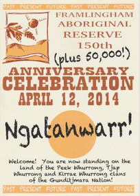
Booklet - 150 plus Framlingham Aboriginal Reserve, 2014
The Framlingham Aboriginal Trust is a shareholder- owned organization established under Victorian law in 1971. The Trust owns and manages part of what was the old Aboriginal Reserve established in 1861 under the auspices of the Church of England. In 1865 the Reserve was officially established as a Government-managed aboriginal station. By 1970 the original area of 3,500 acres was whittled down to 585 acres and handed over to the Framlingham Aboriginal Trust. Framlingham is today one of only two discrete aboriginal communities in Victoria where aborigines live on aboriginal land and is an important part of the district cultural life. The celebration of the 150th anniversary of Framlingham’s establishment in 2014 was therefore a significant event in the district’s history and the booklet is a permanent reminder of this.This is a small booklet of 8 pages containing information on the 150th celebrations of Framlingham Aboriginal Reserve in 2014. The cover has a cream background with illustrations and printed material in yellow, black and brown. The pages are stapled. The booklet includes photographs, maps, illustrations and printed material. Front cover: ‘Framlingham Aboriginal Reserve 150th Anniversary Celebration, April 12, 2014, Ngatanwarr’ etc Back cover: Acknowledgements of sponsors and written material framlingham aboriginal trust, western district aborigines, peek whurrong, kirrae whurrong, gunditjmara, tjap whurrong -
 Warrnambool and District Historical Society Inc.
Document - Ledger: Warrnambool Shire Letter book 1861-1865, Circa 1860
Contains correspondence pertaining to matters of infrastructure in the period of the 1860’s. The period contained within this ledger is very early in the establishment of the district. It shows the co-operation and initiative between councils, government departments and individuals in matters relating drainage, bridges , roads all vital to the development of the region.Fawn cloth on card cover with tan corner and spine binding. Contains alphabetical index at the front. Letters are written on very fine paper.: On the spine is a paper label, “January1861-April 1865.Label inside front cover “Sands &Kenny. Account Book Manufacturers, Stationers &Printers, Collins St Melbourne. The index contains the following names :W G Allan, Bostock, Biggs, Bench of Magistrates Caramut, Niel Black, Commissioner of the Crown Lands Warrnambool, Commissioner of Roads and Bridges, Cross, Carr, Duffy, Davies, Duffus, Fitzmaurice, Horace Flower warrnambool, warrnambool shire, tenders, district roads board, a davies, 1861-1865 -
 Orbost & District Historical Society
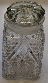
glass container, first half 20th century
Used as a pickle bottle by Mary Gilbert, local historian and Orbost high school teacher. . Mary Isabelle Gilbert was born in 1905 in Orbost, Australia. She was born to John Gilbert and Annie Cameron Gilbert, and had seven sisters and one brother. Four siblings died at a young age. .She was a teacher historian loved and respected by her family and the wider community.Mary Gilbert, B.E.M. was devoted to Orbost. She taught in Orbost for 40 years. She fostered the Orbost Historical Society and initiated the establishment of the Orbost Museum.Cut glass square shaped bottle with lid (202.2). Square designs with large diamond shape in centre.glass-container gilbert-mary -
 Orbost & District Historical Society
black and white photographs, late 19th century - early 20th century
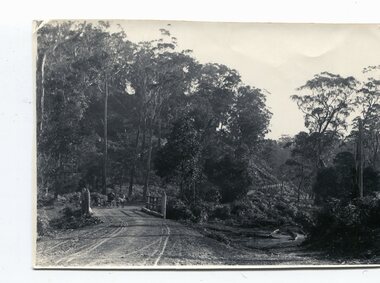
3254.1 shows aTculvert over the gully at the foot of Burn’s Hill cutting at Newmerella and has been taken looking up tpward Burn's Cutting at Newmerella .Photograph 3254.2 has been taken from below the cutting. More information in Newsletter, November 2010.These photographs are pictorial records of Burn's Cutting and the old coach road in a time before the establishment of the Orbost to Bairnsdale railway line.Two black / white photographs of a gravel road on the side of a cutting. Both have a coach on the road. burn-road-newmerella cutting-newmerella coach-road-newmerella -
 Flagstaff Hill Maritime Museum and Village
Artwork, other - Wall decoration, Vera Giles, late 19th to early 20th century
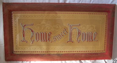
During the Victorian era, the period (1837-1901) in which Queen Victoria ruled England. The queen’s influence was felt throughout the world, including in the United States and Australia where Victorian values shaped society and style, especially in home décor. This period’s distinct style presents an eclectic mix of highly ornamented furniture, wallpaper, and knick-knacks. Particularly in terms of furniture, and the characteristic floral patterns and rich, contrasting colours, wall hanging that enjoyed the height of its popularity during the Victorian era were of the spiritual type with an either embroidered or punched paper religious motto or bible quote. Mottoes were commonly hung high up on the wall or in an area of prominence, to remind the viewer of their important message, such as "Home sweet Home “He Leadeth Me” and “Honesty, Industry, and Sobriety.” Short and pithy, they embodied the ideals of Victorian society. Technological advances contributed to the boom of religious mottoes whereas before the Industrial Revolution home décor of this sort was handmade and therefore minimal, now consumers could purchase and fill their homes with all sorts of mass-produced ephemera goods similar to the subject item. Many of these mass-produced period pieces still exist today, often in their original frames, ceramic, or paper formats. Flagstaff maritime museum has many examples of mottoes on display that serve to reflect the period in which values of home, faith, and Christianity were very prominent in everyday Victorian society. For more information on the Giles collection see Acquisition section this document: An item that reflects the social values and attitudes of the late Victorian era that was used to promote good Christian and moral values in many households. These items of decoration were very popular at this time and the subject item is significant as it gives a snapshot into the social norms of past generations. The Giles family collection is of additional social significance at a local level, because it not only illustrates the level of material support the Warrnambool community gave to Flagstaff Hill during it’s establishment. But the Giles collection also gives us an additional view into what domestic life was like in early colonial times prior to Federation.Wall decoration, framed handmade embroidered tapestry with the woven inscription, Frame has velvet cover. This item is part of the Giles CollectionHome Sweet Home, in gothic scriptflagstaff hill, warrnambool, shipwrecked coast, flagstaff hill maritime museum, flagstaff hill maritime village, great ocean road, soft furnishing, wall decoration, home sweet home, wall hanging, handmade wall hanging, giles collection, henry giles, tower hill, cooramook, warrnambool breakwater, mailor’s flat, wangoom, 19th century handcraft, mrs vera giles -
 Flagstaff Hill Maritime Museum and Village
Photograph, Joseph Jordan Photographic Studio, Miss Christina Giles, before May 1899
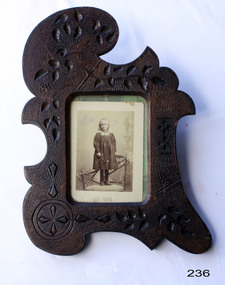
This photograph is of Christina Giles, who died in Wangoom, Warrnambool, in 1899 at 7 years, 5 months and 4 days old and is one of many 19th century items of furniture, linen and crockery donated to Flagstaff Hill Maritime Village by, Vera and Aurelin Giles. The items are associated with Warrnambool and the Giles Family history. Items donated by the family have come to be known as the “Giles Collection”. Many items in the Lighthouse Keeper’s Cottage were donated by Vera and Aurelin Giles and mostly came from the home of Vera’s parents-in-law, Henry Giles and his wife Mary Jane (nee Freckleton) who married in 1880 and whose photos are on display in the parlour. Henry was born at Tower Hill in 1858, and was a labourer on the construction of the Warrnambool Breakwater before leaving in 1895 for around seven years to build bridges in NSW. Mary Jane was born in 1860 at Cooramook and she attended Mailor’s Flat State School and where she eventually was to become a student teacher. After which she became a governess at “Injemiara” where her grandfather, Francis Freckleton, had once owned land. Henry and Mary’s family consisted of six, some of the children were born at Mailor’s Flat and later some children at Wangoom. They lived with their parents at Wangoom and Purnim west, and this is where Henry died in 1933 and Mary Jane in 1940. Jordan, Warrnambool refers to Joseph Jordan who operated a photographic studio in Warrnambool from the late 1880s. His work was prevelent in Victoria's Western District of Victoria.This photograph of Christina Giles is of social significance at a local level, because it not only illustrates the level of material support the Warrnambool community gave to Flagstaff Hill during it’s establishment. But the Giles collection also gives us today a snapshot into what domestic life was like in early colonial times prior to Federation and the high mortality rates amongst children during the early years of colonial settlement. The photograph is also significant for is association with renowned Western District photographer, Joseph Jordan.Photograph of Christina Giles standing on chair in a decorative carved wood frame with floral design in abstract shape. Photo by Jordan of Warrnambool. Christina Giles died in Warrnambool in 1899 at 7 years, 5 months, 4 days of age. It is part of the Giles Family Collection. "Jordan Warrnambool" ( Photographers) flagstaff hill, warrnambool, shipwrecked coast, flagstaff hill maritime museum, maritime museum, shipwreck coast, flagstaff hill maritime village, great ocean road, christina giles, giles collection, giles family, giles history, henry and mary giles, henry giles, tower hill, cooramook, warrnambool breakwater, mailor’s flat, wangoom, 19th century personal effects, joseph jordan, jordan photography -
 Flagstaff Hill Maritime Museum and Village
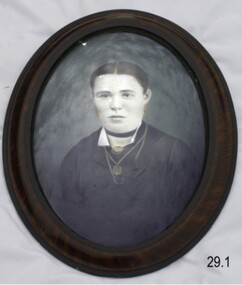
Photograph - Mrs Mary Jane Giles of Woodford, International Art Company, Circa 1880
The pair of photographs of Mr Henry and Mrs Mary Jane Giles was made by the International Art Company, the price was 30 shillings and the choice of frame was Rosewood. It is part of the Giles Collection, which also includes a photograph of the couple's daughter Christina Giles, who died in 1899 aged seven years. There are many 19th century items of furniture, linen and crockery donated to Flagstaff Hill Maritime Village by, Vera and Aurelin Giles. The items are associated with Warrnambool and the Giles Family history. Items donated by the family have come to be known as the “Giles Collection”. Many items in the Lighthouse Keeper’s Cottage were donated by Vera and Aurelin Giles and mostly came from the home of Vera’s parents-in-law, Henry Giles and his wife Mary Jane (nee Freckleton) who married in 1880 and whose photos are on display in the parlour. Henry was born at Tower Hill in 1858, and was a labourer on the construction of the Warrnambool Breakwater before leaving in 1895 for around seven years to build bridges in NSW. Mary Jane was born in 1860 at Cooramook and she attended Mailor’s Flat State School and where she eventually was to become a student teacher. After which she became a governess at “Injemiara” where her grandfather, Francis Freckleton, had once owned land. Henry and Mary’s family consisted of six, some of the children were born at Mailor’s Flat and later some children at Wangoom. They lived with their parents at Wangoom and Purnim west, and this is where Henry died in 1933 and Mary Jane in 1940.This photograph is locally significant due to its association with a local pioneering family. The Giles family collection is of social significance at a local level, because it not only illustrates the level of material support the Warrnambool community gave to Flagstaff Hill during it’s establishment. But the Giles collection also gives us today a snapshot into what domestic life was like in early colonial times prior to Federation. The photograph itself is of added significance as we can see the faces of the family whose lives the collection represents . Portrait photograph mounted in an oval rosewood frame, one of a pair. This photograph is Mary Jane Giles, dressed formally showing chest to head. Her hair is tied back hair and she has a neck band. The couple in the pair of photographs is Mr and Mrs Giles of Woodford, Victoria. The photographic studio was the International Art Company. It is part of the Giles Collection.Inscription on back of frame "International Art Company 30/-" "Rosewood"flagstaff hill, warrnambool, shipwrecked coast, flagstaff hill maritime museum, shipwreck coast, flagstaff hill maritime village, great ocean road, photograph late 1800s, oval wooden frame, portrait, mrs mary jane giles of woodford victoria, giles collection, henry giles, tower hill, cooramook, warrnambool breakwater, mailor’s flat, wangoom, 19th century personal effects, mary giles, christine giles -
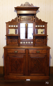 Flagstaff Hill Maritime Museum and Village
Furniture - Sideboard, Circa 1880
This sideboard was from the home of Henry and Mary Jane Giles, who lived in Mailor's Flat, Wangoom, and Purnim West, Victoria, and is part of the many 19th century items of furniture, linen, and crockery donated to Flagstaff Hill Maritime Village by, Vera and Aurelin Giles. The items are associated with Warrnambool and the Giles Family history. Items donated by the family have come to be known as the “Giles Collection”. Many items in the Lighthouse Keeper’s Cottage were donated by Vera and Aurelin Giles and mostly came from the home of Vera’s parents-in-law, Henry Giles, and his wife Mary Jane (nee Freckleton) who married in 1880 and whose photos are on display in the parlour. Henry was born at Tower Hill in 1858, and was a labourer on the construction of the Warrnambool Breakwater before leaving in 1895 for around seven years to build bridges in NSW. Mary Jane was born in 1860 at Cooramook and she attended Mailor’s Flat State School and where she eventually was to become a student-teacher. After which she became a governess at “Injemiara” where her grandfather, Francis Freckleton, had once owned land. Henry and Mary’s family consisted of six, some of the children were born at Mailor’s Flat, and later some children at Wangoom. They lived with their parents at Wangoom and Purnim west, and this is where Henry died in 1933 and Mary Jane in 1940.The Giles family collection is of social significance at a local level, because it not only illustrates the level of material support the Warrnambool community gave to Flagstaff Hill during it’s establishment. But the Giles collection also gives us today a snapshot into what domestic life was like in early colonial times prior to Federation.Kauri Pine Mirror Backed Sideboard, two drawers and two doors to the base, the doors being carved in the traditional manner with a leaf design, brass swing handles are fitted to each of the drawers. The back has two shelves each supported on two turned columns, three mirrors are fitted into carved panels matching design as doors.The pediment is also carved in the same manner finishing with scrolled edges. Circa 1880. This item is part of the Giles Collection.Marked "Villa Rica" "Ambassadors" "Claro" "50" In pencilflagstaff hill, warrnambool, shipwrecked coast, flagstaff hill maritime museum, shipwreck coast, flagstaff hill maritime village, sideboard, furniture, dresser, giles collection, henry giles, vera giles, tower hill, cooramook, mailor’s flat, wangoom, 19th century furniture, purnim west, 1880s furniture -
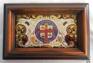 Flagstaff Hill Maritime Museum and Village
Plaque - Insignia, Bank of Australasia, 19th Century
This decorative plaque displays the insignia of the Bank of Australasia, which was incorporated by the Royal Charter of England in March 1834. The bank began in Australia on 14th December 1835, opening in Sydney. The Acting Superintendent of the bank at that time was David Charters McArthur. He was Superintendent from 1867-to 1876. The Melbourne branch opened on 28th August 1838 in a two-roomed brick cottage on the north side of Little Collins Street, where two huge mastiff dogs were used at night to guard the bank. The government also provided an armed military sentinel. Due to the bank's rapid growth, a new building for the Melbourne branch was opened in 1840 at 75 Collins Street West. By 1879 the bank had been upgraded to a magnificent two-storey building on the corners of Collins and Queens Streets, with the entry on Collins Street. In 1951 the Bank of Australasia amalgamated with the Union Bank to form the Australia and New Zealand Bank, now known as the ANZ. Then in 1970, the ANZ merged with both the ES&A and the London Bank of Australia to form the ANZ Banking Group Limited. The ANZ Banking Group Ltd kindly donated a variety of historic items from the Bank of Australasia. BANK of AUSTRALASIA, WARRNAMBOOL – In 1854 Warrnambool had two banks, the Union Bank and the Bank of Australasia. Later, completely different bank businesses opened; in 1867 the National Bank of Australasia, then in 1875 the Colonial Bank of Australasia. The original Warrnambool branch of the Bank of Australasia was established in July 1854, and operated from a leased cottage on Merri Street, close to Liebig Street. The bank later bought a stone building previously erected by drapers Cramond & Dickson on the corner of Timor and Gibson Streets. Samuel Hannaford was a teller and then Manager at the Warrnambool branch from 1855 to 1856 and the Warrnambool Council chose that bank for its dealings during 1856-57. In 1859 Roberts & Co. was awarded the contract to build the new Bank of Australasia branch for the sum of £3,000. The land was on a sand hill on the northeast corner of Timor and Kepler Streets and had been bought in 1855 from investor James Cust. The new building opened on May 21, 1860. The bank continued to operate there until 1951 when it merged with the Union Bank to form the ANZ Bank, which continued operating from its Liebig Street building. Warrnambool City Council purchased the former Bank of Australasia building in 1971 and renovated it, then on 3rd December 1973 it was officially opened as the Art Gallery by Cr. Harold Stephenson and Gallery Director John Welsh. The Gallery transferred to the purpose-built building in Liebig Street in 1986 and the old bank building is now the Gallery club. Staff at the Bank of Australasia in Warrnambool included the following men but others were also involved: Samuel Hannaford, Teller then Manager from 1855-1856; W H Palmer, Manager from January 1857 until November 1869 when the Teller Basil Spence was promoted to Manager; H B Chomley, Manager from April 1873 and still there in 1886; A Butt, Manager in 1895-1904; J R McCleary Accountant and Acting Manager for 12 months, until 1900; A Kirk, Manager 1904; J Moore, staff until his transfer to Bendigo in December 1908; J S Bath was Manager until 1915; C C Cox, Manager until April 1923; Richard C Stanley, Manager 1923 to April 1928. The plaque has historical significance as it belonged to the Bank of Australasia which was established in Australia in 1835 by Royal Charter. The plaque is significant for its association with the Bank of Australasia in Warrnambool, the first bank in Warrnambool, established in 1854. The bank continued to operate until its merger in 1951 when it became the ANZ Bank, which is still in operation today. The Bank was an integral part of the establishment and growth of commerce in Colonial Warrnambool and throughout Australia.Plaque with insignia on glass in a rectangular varnished wooden frame. Insignia of the Bank of Australasia has been painted onto the glass in a mirror-like fashion. Insignia depicts a heraldic shield with sheep hung up by their waists and ships in full sail. Inscription on insignia. Stamp and handwritten inscription on the rectangular label with a blue border on the reverse.Insignia: "BANK OF AUSTRALASIA INCORPORATED BY ROYAL CHARTER 1835" Label's red oval stamp with "AUSTRALIA AND NEW ZEALAND BANK UNITED ARCHIVES" Label's handwritten black letters "AM1" flagstaff hill, warrnambool, shipwrecked coast, flagstaff hill maritime museum, maritime museum, shipwreck coast, flagstaff hill maritime village, great ocean road, commerce, banking, plaque, insignia, bank of australasia, insignia on glass, union bank, australia & new zealand bank, anz bank, david charters mcarthur, d c mcarthur, sydney, new south wales, currency, banknote, legal tender -
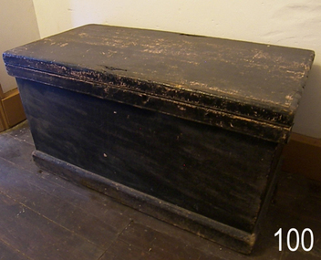 Flagstaff Hill Maritime Museum and Village
Furniture - Linen Chest, First half of the 19th Century
This chest came from County Cavan, North Ireland, with Jane Fleming, when she migrated to Australia arriving at Port Fairy in approximately 1863. Jane Flemming was about 6 or 7 years old at the time and later was to become the mother of Mary Jane Giles (nee Flemming). This chest is one of many 19th century items of furniture, linen and crockery donated to Flagstaff Hill Maritime Village by, Vera and Aurelin Giles. The items are associated with Warrnambool and the Giles Family history. Items donated by the family have come to be known as the “Giles Collection”. Many items in the Lighthouse Keeper’s Cottage were donated by Vera and Aurelin Giles and mostly came from the home of Vera’s parents-in-law, Henry Giles and his wife Mary Jane (nee Freckleton) who married in 1880 and whose photos are on display in the parlour. Henry was born at Tower Hill in 1858, and was a labourer on the construction of the Warrnambool Breakwater before leaving in 1895 for around seven years to build bridges in NSW. Mary Jane was born in 1860 at Cooramook and she attended Mailor’s Flat State School and where she eventually was to become a student teacher. After which she became a governess at “Injemiara” where her grandfather, Francis Freckleton, had once owned land. Henry and Mary’s family consisted of six, some of the children were born at Mailor’s Flat and later some children at Wangoom. They lived with their parents at Wangoom and Purnim west, and this is where Henry died in 1933 and Mary Jane in 1940.The chest is of historical significance as an example of an early piece of furniture brought to Australia by Jane Flemming when she migrated to Australia during the mid 19th century. The chest is associated with the Giles family as Jane later was to become the mother Of Mary Jane Giles (nee Flemming). The Giles family collection is of social and historical significance at a local level, because it not only illustrates the level of material support the Warrnambool community gave to Flagstaff Hill during it’s establishment. But the Giles collection also gives us today a snapshot into what domestic life was like in early colonial times prior to Federation. Linen chest wood construction with hinged lid and lock. Hinges are brass. Painted black. ( Giles Collection)Noneflagstaff hill, warrnambool, shipwrecked coast, flagstaff hill maritime museum, shipwreck coast, flagstaff hill maritime village, wooden chest, cabin trunk, giles collection, henry giles, tower hill, cooramook, mailor’s flat, wangoom, 19th century household goods, jane flemming, mary jane giles, linen chest -
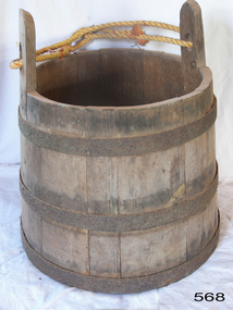 Flagstaff Hill Maritime Museum and Village
Domestic object - Coopered Bucket, 1960 to 1980
This bucket was made from vertical planks of wood with bands of metal around it for strength. Buckets such as this were made by coopers, who had expertise in making wooden barrels. Wood or animal skin was used to make buckets in colonial times when other materials were unavailable. Buckets had many uses in domestic and agricultural life including carrying, measuring and storing. Cooper tradesmen used carpentry and blacksmithing skills to make a wide range of wooden containers and other objects. They sometimes used water or steam to bend and mould the timber.The bucket is an example of a product made from wood and iron by an experienced Cooper. In early colonial timeswhen ready-made products were scarce so the trades of coopers, blacksmiths, metal smiths, carpenters, builders and others were necessary for domestic, commercial and industrial establishment.Wooden coopered bucket; three metal bands around vertical wooden planks that form the body of the bucket. Two lugs extend higher than the planks and have a rope joined between them.warrnambool, shipwreck coast, flagstaff hill, flagstaff hill maritime museum, flagstaff hill maritime village, bucket, wooden bucket, container, domestic bucket, cooper, cooper trade, coopered bucket -
 Flagstaff Hill Maritime Museum and Village
Clothing - Button, c. 1845
THE CATARAQUI The Cataraqui was built in 1840 in Quebec, Canada, and wrecked on 4th August, 1845 off the west coast of King Island, Australia. The lives of 400 people on the emigrant ship were lost. Many of them were on government assisted passages from Britain and Ireland. Only nine people, one passenger and eight crew, survived the shipwreck. A man who lived on the island, sheltered them and five weeks later the group was rescued by the ship Midge, which took them to Melbourne. It was the largest civilian maritime disaster.The button is significant as an example of a 19th century clothing accessory. The button is also significant for its association with the 1840 Canadian built ship, Cataraqui. The Cataraqui is significant in maritime history as Australia's largest civilian maritime disaster. The wreck also has a connection to the establishment of the Cape Otway lighthouse and to Warrnambool’s history as Superintendent Charles LaTrobe came to the Warrnambool district several times in an effort to find the best route to the Cape Otway area. While doing so he became familiar with the Warrnambool area and the need to establish a new settlement as Warrnambool.Metal button, vertical shank on back. Button experiencing corrosion and one edge has been eaten away. Inscription and two circular markings on shank side of button. Salvaged from the wreck of the Cataraqui.Unable to decipher.flagstaff hill maritime museum & village, shipwreck coast, great ocean road, button, king island, shipwreck, maritime disaster, cape otway, cataraqui -
 Federation University Historical Collection
Document - Document - Proposal, VIOSH: Ballarat College of Advanced Education; Support for the Establishment of a Control Solution Data Bank, 1982
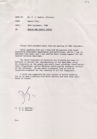
Victorian Institute of Occupational Safety and Health (VIOSH) Australia is the Asia-Pacific centre for teaching and research in occupational health and safety (OHS) and is known as one of Australia's leaders on the field. VIOSH has a global reputation for its innovative approach within the field of OHS management. VIOSH had its first intake of students in 1979. At that time the Institution was known as the Ballarat College of Advanced Education. In 1990 it became known as Ballarat University College, then in 1994 as University of Ballarat. It was 2014 that it became Federation University. VIOSH Australia students are safety managers, senior advisors and experienced OHS professionals. They come from all over Australia and industry. Students are taught active research and enquiry; rather than textbook learning and a one-size fits all approach. VIOSH accepts people into the Graduate Diploma of Occupational Hazard Management who have no undergraduate degree - on the basis of extensive work experience and knowledge Memo from Dennis Else to E J Barker, Director of BCAE outlining the support externally for a Health and Safety Centre in Ballarat. The Chief Inspector of Factories in Victoria has also discussed the implementation of a Data Bank to allow input of solutions to various problems discovered on inspections. A detailed document for the case for developing the centre at Ballarat prepared by Dr Dennis Else, Visiting Fellow. He suggests a meeting with Derek Woolley, Head of Engineering and other Heads of School be held.Seven A4 pages, typed - some with hand written notationsD S (Dennis Else)viosh, victorian institute of occupational safety and health, dennis else, e j barker, ballarat college of advanced education, health and safety centre ballarat, chief inspector of factories, data bank, solutions to problems, derek woolley -
 Federation University Historical Collection
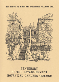
Booklet - Programme, Bill Ryan, Centenary of the Establishment Botanical Gardens 1879-1979, 1979
The Ballarat School of Mines was established in 1879, making it the first site of Technical Education in Australasia. In 1879 a Botanical Garden was established in the grounds of the Ballarat School of Mines, and was used for the teaching of Materia Medica, Botany, and related subjects. An A4 folded booklet produced for the centenary of the Ballarat School of Mines Botanical Gardens. ballarat school of mines botanical gardens, ballarat school of mines, botanical gardens, george porter day, john noble wilson, materia medica, james oddie, francis usher, emil gutheil, botany, jessie knox smith, norfolk pine, parks and gardens