Showing 5871 items
matching 1885-1972
-
 Melbourne Tram Museum
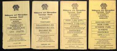
Ephemera - Timetables - MMTB Buses - set of 13, Melbourne & Metropolitan Tramways Board (MMTB), 1971 to 1973
Timetables - provide information on ticketing, fares, timing points, with a description of the route and a map. Not all services had been allocated a route number at the time. 1 - Garden City - Port Melbourne - City - routes 201, 202 - August 1972 2 - Williamstown Road - Footscray - Ballarat Rd - Route 223, Feb. 1972 3 - Deer Park, Sunshine Park, Sunshine, Footscray - City - routes 217, 219, 220, 229, 231 and 218 - Feb. 1972 4 - Deer Park West, Sunshine Park, Sunshine, Footscray - City - July 1973 5 - Fishermen's Bend - City - routes 233, 235 and 237 - March 1972 6 - Clifton Hill - Esternwick - Point Ormond - routes 246, 247 and 248 - August 1972 7 - Latrobe Uni - Northland - West Heidelberg - City - routes 256, 251, 253, 254, 252 and 255 August 1972 8 - East Kew, Box Hill, Doncaster, Shoppingtown - routes 284, 285 and 270 - July 1972 9 - Box Hill, Mitcham, East Doncaster, Ringwood - routes 287, 286, 288, 282, 283, and 272 - July 1972 10 - Box Hill - North Blackburn, route 290, printed on white paper - Sep. 1971 11 - Box Hill - Doncaster, Shoppingtown, Heidelberg, Templestowe, Serpells Rd and Lower Templestowe - routes 293, 296, 297, 271 - July 1972 12 Deer Park, Sunshine Park, Sunshine, Footscray - City - routes 217, 219, 220, 229, 231 and 218 - Saturdays and Sundays, printed on green paper - Feb. 1972 13 - Fishermans Bend - City - routes 233, 235 and 237 - June 1973 Yields information about MMTB Bus services during the 1970s. Set of twelve MMTB Bus timetables - multifolded printed on yellow paper, unless noted otherwise. timetable, mmtb, buses, port melbourne, garden city, williamstown rd, footscray, ballarat rd, sunshine, deer park, fisherman's bend, clifton hill, esternwick, point ormond, la trobe university, northland, west heidelberg, east kew, box hill, doncaster, shoppingtown, mitcham, ringwood, blackburn, templestowe, lower templestowe, fishermans bend -
 Mt Dandenong & District Historical Society Inc.
Photograph, Clarke Family 1911
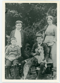
John Lundy-Clarke grew up in the Kalorama/Mt Dandenong area and later in life (1972-74) began to write a comprehensive history of the district working from an original settlement map in an effort to cover all areas. The Lundy-Clarke family were related to the Price family through the marriage of two Ross sisters - Annie Ross to Edward Joseph Price and Helen Ross to Robert Lundy-Clarke. Edward Joseph Price took up Lot 1 in the Village Settlement and Robert Lundy-Clarke was persuaded to take up Lot 2. He felt it would be unproductive. He signed it over to Edward Joseph Price and took his family to New Zealand. After his death in 1911 the family returned to the district. The Lundy-Clarke family were related to the Dunbar family as Caroline Dunbar was a sister to Annie and Helen Ross. Agnes Annie Clarke aged 18 daughter of Robert Lundy-Clarke and Helen nee Ross. Born 1893 died 1974. James Ross Clarke aged 12 son of Robert Lundy-Clarke and Helen nee Ross. Born 1898 died 1972. John Lundy-Clarke aged 10 son of Robert Lundy-Clarke and Helen nee Ross. Born 1901 died 1993. John Stewart Dunbar aged 13 son of Andrew Dunbar and Caroline nee Ross. Born 1898. This photograph was taken in 1911 in the grounds of Dunbar's Hazeldene Dairy in Falls Road. Black and white photograph showing four young people outdoors in a group. A girl and boy standing with two boys seated on chairs, one holding a dog. Reverse of photograph has handwritten description by John Lundy-Clarke.1911 Right to left - Agnes Annie Clarke aged 18 daughter of R. Lundy-Clarke and Helen nee Ross. Born 1893 died 1974. James Ross Clarke aged 12 brother of Agnes. Born 1898 died 1972. John Stewart Dunbar son of Andrew Dunbar and Caroline nee Ross. Born 1898. John Lundy-Clarke. Brother of Agnes with "Possum" (Apart from Agnes, not sure of the accuracy of the other name placements)lundy-clarke, john lundy-clarke, robert lundy clarke, agnes clarke, james clarke, john dunbar, andrew dunbar, caroline dunbar, caroline ross, helen lundy-clarke, helen ross, annie ross, annie price, dairy, hazeldene, hazeldene dairy, dunbar's dairy, falls road -
 Clunes Museum
Album - SCRAPBOOK, F C. WEICKHARDT, UNKNOWN
Depicts history of Clunes 1839-1972Black cardboard covered album containing photographs and text, loosely bound. Complied by F.C. WeickhardtClunes, A Pictorial History by F.C. Weickhardtf.c. weickhardt, pictorial history of clunes -
Unions Ballarat
Out of the wilderness : the return of Labor, Lloyd, CJ et al, 1974
The return of Labor to government in 1972 to 1974.Relevant to Australian political history and history of the ALP.Paper; book. Blue and white cover with black and white portrait photographs.Front page: title and authors' name.btlc, ballarat trades hall, ballarat trades and labour council, whitlam, eg, whitlam, gough, australian labor party, alp, elections, government, whitlam government - dismissal, parliament, mcmahon, william, prime minister -
 Bendigo Historical Society Inc.
Document - BASIL MILLER COLLECTION: TRAMS - 'RUNNING JOURNAL', December 1972
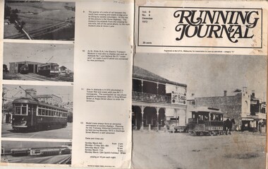
Journal of the Tramway Museum Society of Victoria. Ltd. Volume 9, No. 6. December 1972, 35 cents, thirteen pages. Cover photo (right) shows Sydney Road Coburg looking south from Bell Street with horse tram bound for the Brunswick cable tram terminus at Moreland Road. The horse tram was established by the Northern Tramway Company in 1889. Purchased by the Coburg Council in 1911 they operated until 1916 when replaced by the electric trams of the Melbourne Brunswick and Coburg Tramway Trust. History of document: Part of 'Basil Miller Tramways Collection'.document -
 Bendigo Historical Society Inc.
Photograph - NEWSPAPER CUTTING: JOHN HANLON KNIPE CASTLE, 1972
Photographs (2) and newspaper cutting Newspaper cutting 2268a ( photocopy ) photocopied and attached to board. Article was researched by Edith Lunn. Article from Bendigo Advertiser April 15th. , 1972. On rear of board, two black and white photos ( 20 x 14 ) of Knipe's castle. 2268b: close up photo taken from street of Knipe's Castle, showing turrets, corner view. 2268c: photo taken from Bendigo CBD looking up toward Forest St. and Valentine Sts area. Knipe's Castle is visible on skyline.buildings, house, knipe's castle, bendigo, john hanlon knipe, castle, edith lunn -
 Ballarat Tramway Museum
Photograph - Digital image, John Ward, 2/01/1972 12:00:00 AM
Digital image of the Bendigo tram 29 turning from Pall Mall into Mitchell St with the destination of Railway Station. In the background is the Fountain Plaza, advertising Melba Frocks and Gidgette Boutique, the City Family Hotel, Park Lane chicken shop. In the foreground is the Inspector returning the point bar to its holder on a pole. Photo by John Ward 2-1-1972. Slide title "04771 020172 7210-F SECV Birney tram 29 Pall Mall to Mitchell St at High St & View St Charing Cross Bendigo Vic"trams, tramways, bendigo, pall mall, mitchell st, charing cross, tram 29 -
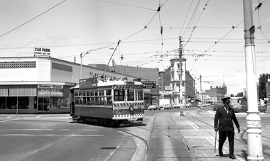
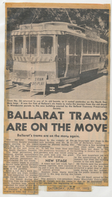 Ballarat Tramway Museum
Newspaper, The Courier Ballarat, "Ballarat Trams are on the Move", 17/06/1972 12:00:00 AM
Newspaper clipping from The Courier, Ballarat, dated Saturday, 17 June 1972, titled "Ballarat Trams are on the Move". Reports on the move of tram No. 26 from the SEC Depot to the BTPS depot the previous day. Quotes Society Vice-president, Mr. M. Calnin. Took all day to complete the move on one of the trams. Three other trams had been moved to the loop during the afternoon. Has a photo of No. 26 at the Gardens Loop. One of a large group of newspaper cuttings from John Bainbridge, 7/4/02.depot, buildings, btps, moving trams, gardens loop -
Kew Historical Society Inc
Archive (Sub-series) - Subject File, Kew Historical Society, Hamer Court (Kew), 1972
Various partiesReference, Research, InformationSecondary Values (KHS Imposed Order)A large subject file containing material relating to Hamer Court Hostel for the Aged in Childers Street / High Street, Kew. The materials date from the early 1970s before Hamer Court was opened. The file contains correspondence to and from the Society and original [very frail] plans for the construction of the hostel (1972) and later plans for extensions (undated). Other original documents in the file include a programme for the official opening (of the extensions?) in 1983, agendas and minutes of meetings and promotional materials. Many of the items filed also relate to the Kew Elderly Citizens Association.kew historical society - archives, hamer court - high street - childers street - kew (vic), aged care - kew (vic)kew historical society - archives, hamer court - high street - childers street - kew (vic), aged care - kew (vic) -
 Eltham District Historical Society Inc
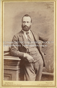
Photograph, Burman's Photographic Rooms, Possibly William James Sommerville, c.1885
William James Sommerville (b.1856) married Jane Shillinglaw at Hawthorn, Victoria, June 2, 1887. He was ten years Jane's junior. It is possible that this may be a carte-de-visite of William presented by him to Jane during their courtship as it is dated at least two years prior to their marriage. According to Sands & McDougall Melbourne Directory, Burman's were operating from 209 Bourke St. East and St George's Hall (73 Bourke St. East) from 1879-1885 CARTE-DE-VISITE (cdv) 1857-1890 Cartes-de-visite (cdv's) are the most common form of photograph from the nineteenth century, generally measuring two and a half inches by four and an eighth inches (6.3 x 10.5 cm) when mounted, sepia toned, mounted on a card which was generally printed with the photographer's name and address on the back or beneath the portrait. - Frost, Lenore; Dating Family Photos 1850-1920; Valiant Press Pty. Ltd., Berwick, Victoria 19911879-1885, 1885, burman's photographer 209 bourke st east and st georges hall melbourne, marg ball collection, shillinglaw family photo album 1, unknown, william james sommerville -
 Federation University Historical Collection
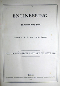
Book, Engineering: an illustrated weekly journal, 1884 (exact)
William Henry Maw was a British civil engineer and astronomer. He was born in 1838 and died in 1924 at eighty-five years. Maw worked as an assistant at the workshops of the Eastern Counties Railway before he became a draughtsman in the design office. He designed the first outside cylinder locomotive for use in India. In 1865 he founded the journal Engineering and continued to be an editor for the rest of his life. Maw became a consulting engineer. He was president of the Civil and Mechanical Engineers' Society, the Institution of Mechanical Engineers and the Institution of Civil Engineers. This book contains a wide range of articles and reviews related to industrial developments such as rail mill engines at the Dowlais iron works (constructed by Messrs. Kitson and Co., engineers, Leeds), cable tramway, Clay-street, San Francisco, U.S.A., road and railway bridge over the river Dnieper, at Jekaterinoslow, Russia (constructed from the designs of Professor N. Belelubsky, St. Petersburg, by the Brjonsk iron works) etc. A book with blue large hard cover. Title and publication date are written on spine in gold. Illustrations (fig., plates, plans, diagrams) in B/W. Includes collection of the engineering weekly journal vol. xxxix-from January to June 1885. This book contains a wide range of articles and reviews related to industrial developments. Page no.712.machinery, tools, engines, engineering, railroad, w h maw, rail, mill engines, cable tramway, clay street, dowlais iron works, twin screw engines, royal italian torpedo ram vessel, messrs r and, w hawthorn engineers, electro plated carriage, the tehuantepec ship railway, otis elevator -
 Bendigo Historical Society Inc.
Newspaper - JENNY FOLEY COLLECTION: BENDIGO
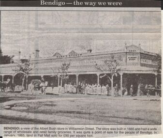
Bendigo Advertiser "The way we were" from 1999. Bendigo: a view of the Albert Bush store in Williamson Street. The store was built in 1885 and had a wide range of wholesale and retail family groceries. It was quite a point of sale for the people of Bendigo. In January, 1865 land in Pall Mall sold for 90 pounds per square foot.newspaper, bendigo advertiser, the way we were -
Bendigo Historical Society Inc.
Document - RESIDENCE AREAS REGISTER: SANDHURST VOLUME 6
Register: hard covered register, maroon material with dark buff spine and corners. Contains A-Z index in front section linked with registration details of residence areas in the Sandhurst district, Sandhurst division. Blue lined pages number 1 - 150 detailing land registrations. Dates from 1 December 1885 to August 1886.place, bendigo, residence areas, bendigo, sandhurst, land registrations, residence areas, land sales -
 Bendigo Historical Society Inc.
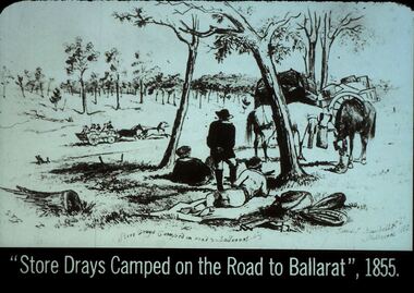
Slide - DIGGERS & MINING. STORES AT THE DIGGINGS, c1855111
Diggers & Mining. Stores at the diggings. ''Store Drays Camped on the Road to Ballarat'', 1855. Slide: Store dray resting on side of road with un covered wagon racing past. STG. Store Drays Camped on roadside to Ballaarat. James - Blum----Dell. Melbourne 1885. Markings: 41 994.LIF. 5. Used as a teaching aid.hanimounteducation, tertiary, goldfields -
 Greensborough Historical Society
Photograph, Unidentified male, 1885c
Studio portrait of unidentified male, taken circa 1885. From the Partington collection.Sepia studio portrait of unidentified male partington family, portrait photographs -
 Port Melbourne Historical & Preservation Society
Photograph - Market shop demolition
Market buildings established 1885. Demolition retained streetscape but allowed new businesses .Colour photo showing Market shop demolition in Bay St 1989. Old frontage retained. Nott St homes and Council flats visible in backgroundbuilt environment - demolition, built environment - commercial, built environment - civic -
Clunes Museum
Document - BOOK EXTRACT, IF I'D ONLY LISTENED TO GRANDPA
MARTIN POWER WAS BORN IN CLUNES IN 1885 AND WAS A MINER IN CLUNES ALL HIS LIFEPHOTOCOPIED CHAPTER. 11 UNNUMBERED PAGES GIVING AN ACCOUNT OF AN INTERVIEW WITH THE LATE MARTIN POWER OF CLUNESlocal history, document, mining -
 Mont De Lancey
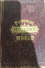
Book, National Publishing Co, Pictorial history of the world
Presented to Emily Venus by her dear Father on her 11th birthday. 1885.Leather bound book titled "Pictorial history of the world".books -
 Glen Eira Historical Society
Album - Album page, Normanby Road, Circa 1972
This photograph is part of the Caulfield Historical Album 1972. This album was created in approximately 1972 as part of a project by the Caulfield Historical Society to assist in identifying buildings worthy of preservation. The album is related to a Survey the Caulfield Historical Society developed in collaboration with the National Trust of Australia (Victoria) and Caulfield City Council to identify historic buildings within the City of Caulfield that warranted the protection of a National Trust Classification. Principal photographer thought to be Trevor Hart, member of Caulfield Historical Society. Most photographs were taken between 1966-1972 with a small number of photographs being older and from unknown sources. All photographs are black and white except where stated, with 386 photographs over 198 pages. From: Glen Eira Heritage Management Plan (1996) - Vol 2 by Andrew Ward and Associates The widening of Dandenong Road during the late 1980's has resulted in the destruction of the houses in the path of the roadworks and the construction of a high fence serving as a visual barrier between that thoroughfare and the remaining houses. Where comparatively large villas once stood on spacious allotments, only "Wisteria" survives at No. 135 Normanby Road. Adopting forms and timber enrichment characteristic of the American Queen Anne style, it has this in common with the largely reconstructed timber villa at no. 11 Normanby Avenue and to a lesser extent, 746 Inkerman Road. Normanby Road retains its comparatively opulent Edwardian character in a mature landscaped setting with spacious gardens and mature planes parallel with the railway reserve which, on account of the low lying ground in its vicinity has a high embankment commencing on the alignment of Malvern Grove and continuing to Caulfield Station. The earliest villas are Edwardian. Page 148 of Photograph Album with one landscape photograph of a house on Normanby Road (not Street).Handwritten: Normanby St [top right] / 148 [bottom right]trevor hart, verandah, porch, bull nosed verandah, tower house, tower, stone fence, normanby road, wisteria, american queen anne style, queen anne style, 1890's, mayfield grove, normanby street, timber houses, caulfield north, house names, edwardian, edwardian style, gardens -
 Glen Eira Historical Society
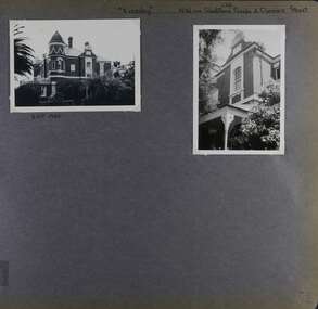
Album - Album page, Eversley, Gladstone Parade & Clarence Street, Circa 1972
This photograph is part of the Caulfield Historical Album 1972. This album was created in approximately 1972 as part of a project by the Caulfield Historical Society to assist in identifying buildings worthy of preservation. The album is related to a Survey the Caulfield Historical Society developed in collaboration with the National Trust of Australia (Victoria) and Caulfield City Council to identify historic buildings within the City of Caulfield that warranted the protection of a National Trust Classification. Principal photographer thought to be Trevor Hart, member of Caulfield Historical Society. Most photographs were taken between 1966-1972 with a small number of photographs being older and from unknown sources. All photographs are black and white except where stated, with 386 photographs over 198 pages. Property now known as Eversley, formerly Nulmore then Brampton. From Caulfield Heritage Management Plan 1996 by Andrew Ward In 1888, C. Hume owned lots 61, 62 and 63 in the Kooyong Park Estate, on the northwest corner of Gladstone Parade and Clarence Street. In 1889 Thomas B. Jackson, architect, of Shoobra Road, purchased the land and in the same year built a ten roomed brick house on lot 63 and part lot 62. Jackson leased the property to William Dalrymple in 1890. By 1894, the property was owned by P. Langwill and leased to James Ainslie, an accountant. By 1899, Frederick Henriques had moved into the house, which was known as ''Nulmore". In 1910, the house was vacant. In 1920, it was leased to Augustine Barbeta who continued to live there in 1930. By 1934, the house was renamed ''Brampton". ''Nulmore" is locally important as an unusually imposing Elizabethan influenced villa in Caulfield, comparing with nos. 34 and 25 Gladstone Parade. Its link with local architect Thomas B Jackson is of interest. Page 52 of Photograph Album with two exterior photographs (one landscape and one portrait) of Eversley , a double storey mansion.Hand written: (36 )[top right] / "Eversley" N.W. cnr Gladstone Parade & Clarence Street [top right] / 8 Oct 1966 [under top left photo] / 52 [bottom right] trevor hart, 1880's, 1890's, gladstone parade, eversley, victorian, clarence street, architectural features, nulmore, brampton, kooyong park estate, architect, shoobra road, hume, elsternwick, double storey mansions, thomas b jackson, william dalrymple, p langwill, james ainslie, frederick henriques, augustine barbeta, elizabethan style, house names -
 Glen Eira Historical Society
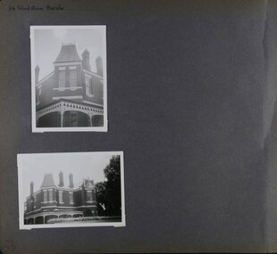
Album - Album page, Gladstone Parade, 34, Circa 1972
This photograph is part of the Caulfield Historical Album 1972. This album was created in approximately 1972 as part of a project by the Caulfield Historical Society to assist in identifying buildings worthy of preservation. The album is related to a Survey the Caulfield Historical Society developed in collaboration with the National Trust of Australia (Victoria) and Caulfield City Council to identify historic buildings within the City of Caulfield that warranted the protection of a National Trust Classification. Principal photographer thought to be Trevor Hart, member of Caulfield Historical Society. Most photographs were taken between 1966-1972 with a small number of photographs being older and from unknown sources. All photographs are black and white except where stated, with 386 photographs over 198 pages. From Caulfield Heritage Management Plan 1996 by Andrew Ward In 1889, Thomas B Jackson, an architect in Shoobra Road, owned lots 61-63 at the north west intersection with Clarence Street. He built the two red brick houses, each of 10 rooms, known as "Kenly" and "Nulmore" (later "Brampton") in that year. By 1894, P. Langwill had purchased the property, leasing it to Fred Henriques, an accountant. Alfred Pearson a government chemist, was occupying tenant by 1899. The property was known as ''Kenly''. In 1910, the house was vacant, however, in 1920, James Edmends was living there and continued to do so in 1930. By 1941, Edmends had moved to No. 32, and Alfred Williamson was in residence. "Kenly'' is important as an unusually imposing Elizabethan influenced villa in Caulfield, comparing with nos. 25 and 36 Gladstone Parade. Its importance is enhanced by its substantially intact state whilst its link with local architect Thomas B Jackson is of interest.Page 53 of Photograph Album with two exterior photographs (one portrait and one landscape) of a double storey brick mansion.Hand written: 34 Gladstone Parade [top left] / 53 [bottom left] trevor hart, 1880's, 1890's, gladstone parade, eversley, victorian, double storey, clarence street, architectural features, nulmore, brampton, kooyong park estate, architect, shoobra road, elsternwick, kenly, elizabethan influence, thomas b jackson, p langwill, fred henriques, alfred pearson, james edmends, alfred wiliamson, house names -
 Glen Eira Historical Society
Album - Album page, Glenferrie Street, 4, Circa 1972
This photograph is part of the Caulfield Historical Album 1972. This album was created in approximately 1972 as part of a project by the Caulfield Historical Society to assist in identifying buildings worthy of preservation. The album is related to a Survey the Caulfield Historical Society developed in collaboration with the National Trust of Australia (Victoria) and Caulfield City Council to identify historic buildings within the City of Caulfield that warranted the protection of a National Trust Classification. Principal photographer thought to be Trevor Hart, member of Caulfield Historical Society. Most photographs were taken between 1966-1972 with a small number of photographs being older and from unknown sources. All photographs are black and white except where stated, with 386 photographs over 198 pages. From Glen Eira Heritage Management Plan 1996 by Andrew Ward: In 1905, most of portion 27 was vacant land, however Glenferrie Street had been formed and the land subsequently subdivided. In 1906, Robert Joseph Haddon, architect and painter, designed and built for his private residence, a brick house on the west side. Haddon named the house "Anselm". Also built on the property were a garage and fibro cement studio. "Anselm" is architecturally important at the State level as a substantially intact, highly personalised and boldly expressed house expressive the Arts and Crafts movement and incorporating Art Nouveaux enrichment in a variety of forms, the use of ornamental terra cotta tiles to the comer tower being of special note. Its importance at the State level is strengthened by its place as the home of the noted architect and Melbourne's most influential exponent (Freeland, J.M., Architecture in Australia, p. 213) of the Art Nouveaux movement.https://vhd.heritagecouncil.vic.gov.au/places/4442 Victorian Heritage Register: What is significant? Anselm was designed by noted English born architect Robert Joseph Haddon(1866-1929) as his own house and constructed in 1906. A single storey Arts and Crafts influenced red brick house with attic, Anselm has a pyramidal slate roof with prominent chimney stacks. There is a octagonal corner tower with saucer shaped domed roof surmounted by a weather vane, and the tower has decorative terracotta panels immediately below the eaves line. The front door opens immediately into a large living or common room, screened from view by a timber and bottle glass screen. The large room was designed to function as a drawing and dining room. The house is rich with hand crafted details including door and window furniture, wrought iron gutter brackets, fireplaces (one with built in wood box), and fire tools. The interior decoration includes hand painted frieze of Port Phillip in the study, and a hand painted frieze of turbulent sea with sailing boats in the tiled bathroom. There is a small hand painted tile at the base of the tower which states ?This building was erected AD1906 from designs by Robt J Haddon FRIBA,Lond FRIVA Melb Architect?. He also designed an attic addition which was constructed in 1927. Anselm is substantially intact although the double casement window immediately to the south of the front door was originally circular....Page 60 of Photograph Album with three exterior photographs (one portrait and two landscape) of Anselm.Hand written: 4 Glenferrie Street [top right] / ANSELM 4 Glenferrie St [under top photo] / 60 [bottom right] trevor hart, anselm, art nouveaux, arts and crafts, tower, bay window, glenferrie street, robert joseph haddon, 1900's, terra cotta tiles, double storey, caulfield north, corner tower, gates, cast iron work -
 Glen Eira Historical Society
Album - Album page, Glenferrie Street, 4, Circa 1972
This photograph is part of the Caulfield Historical Album 1972. This album was created in approximately 1972 as part of a project by the Caulfield Historical Society to assist in identifying buildings worthy of preservation. The album is related to a Survey the Caulfield Historical Society developed in collaboration with the National Trust of Australia (Victoria) and Caulfield City Council to identify historic buildings within the City of Caulfield that warranted the protection of a National Trust Classification. Principal photographer thought to be Trevor Hart, member of Caulfield Historical Society. Most photographs were taken between 1966-1972 with a small number of photographs being older and from unknown sources. All photographs are black and white except where stated, with 386 photographs over 198 pages. From Glen Eira Heritage Management Plan 1996 by Andrew Ward: In 1905, most of portion 27 was vacant land, however Glenferrie Street had been formed and the land subsequently subdivided. In 1906, Robert Joseph Haddon, architect and painter, designed and built for his private residence, a brick house on the west side. Haddon named the house "Anselm". Also built on the property were a garage and fibro cement studio. "Anselm" is architecturally important at the State level as a substantially intact, highly personalised and boldly expressed house expressive the Arts and Crafts movement and incorporating Art Nouveaux enrichment in a variety of forms, the use of ornamental terra cotta tiles to the comer tower being of special note. Its importance at the State level is strengthened by its place as the home of the noted architect and Melboume's most influential exponent (Freeland, J.M., Architecture in Australia, p. 213) of the Art Nouveaux movement. Victorian Heritage Register https://vhd.heritagecouncil.vic.gov.au/places/4442 What is significant? Anselm was designed by noted English born architect Robert Joseph Haddon(1866-1929) as his own house and constructed in 1906. A single storey Arts and Crafts influenced red brick house with attic, Anselm has a pyramidal slate roof with prominent chimney stacks. There is a octagonal corner tower with saucer shaped domed roof surmounted by a weather vane, and the tower has decorative terracotta panels immediately below the eaves line. The front door opens immediately into a large living or common room, screened from view by a timber and bottle glass screen. The large room was designed to function as a drawing and dining room. The house is rich with hand crafted details including door and window furniture, wrought iron gutter brackets, fireplaces (one with built in wood box), and fire tools. The interior decoration includes hand painted frieze of Port Phillip in the study, and a hand painted frieze of turbulent sea with sailing boats in the tiled bathroom. There is a small hand painted tile at the base of the tower which states ?This building was erected AD1906 from designs by Robt J Haddon FRIBA,Lond FRIVA Melb Architect?. He also designed an attic addition which was constructed in 1927. Anselm is substantially intact although the double casement window immediately to the south of the front door was originally circular....Page 61 of Photograph Album with one exterior photograph (portrait) of Anselm.Hand written: 61 [bottom left] trevor hart, anselm, art nouveaux, arts and crafts, tower, bay window, glenferrie street, robert joseph haddon, 1900's, terra cotta tiles, double storey, caulfield north, corner tower, brick house, attics -
 Flagstaff Hill Maritime Museum and Village
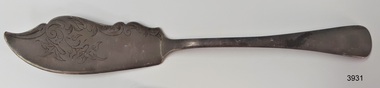
Domestic object - Butter Knife, Barker Brothers, Ca. 1885-1895
This butter or cheese knife is a decorative example of electroplated cutlery that had become an affordable alternative to more expensive silver cutlery in the late 1800s to early 1900s. The knife has stamp marks in the back of its handle that are a combination of letters and symbols used by British silversmiths to identify their workmanship. The design and type of this knife was not normally used by everyday people but rather those of a higher social class with time and money to have a particular decorative knife to serve butter or cheese. The marks on the handle tell that it was made of nickel silver, and electroplated with superior quality Stirling silver. The Barker Brothers of Birmingham made the knife between 1885 and 1907, but most likely before 1895. It was made for the British, or British colonial, people, connected with a government department such as the navy or defence. This story may be slightly inaccurate, as some silversmiths added extra ‘pseudo marks’ to their wares to disguise the quality. THE MARKS and their meaning – - ‘A1’ The silver used in electroplating this knife was the highest level, ‘superior quality’, measured in grams of silver per table spoon or table fork, with ‘A1’ being 2 2/3 grams, and ‘D’ being 0 1/2 grams of silver. - ‘BB’ The Baker Brothers used these initials from 1885 to 1907. - ‘[crown symbol]’ – This symbol is used for Sterling silver but this knife is a metal alloy. The crown is also the town mark of Sheffield (appointed by the Sheffield Assay Office) but this knife was made in Birmingham, which has the town mark of an anchor. The Barker Brothers may have added the crown mark to this electroplated silverware as a ‘pseudo hallmark’, leading the buyer to think that it was actual Sterling silver. The use of pseudo hallmarks by electroplaters of the Victorian era was common practice but it was illegal. In 1895 the unlawful practice was seen as imitating the Sheffield Silver Mark and the law was firmly applied to eradicate the deception, so items with this mark probably date before 1895. - [EPNS] Electro Plated Nickel Silver, called nickel silver or German silver, is a metal alloy that usually combines copper, nickel and zinc (60 percent copper, 20 percent nickel, 20 percent zinc). It has a silver-white appearance and is sometimes referred to as ‘white ware’. It does not contain any silver but is often used as a base for electroplating, when the item is covered with a thin layer of silver to give it the polished appearance of pure silver. It became popular in the late 19th and early 20th century as an affordable substitute for sterling silver. - Broad Arrow - an official stamp that indicates it was once the property of Britain government, either in Britain or one of its colonies, and used in the defence force. In Great Britain, from an 1875 government act, it was, and still, is a crime to forge or wrongfully use, the broad arrow symbol. The BARKER BROTHERS of Birmingham - Barker Brothers were one of the earlies firms of Birmingham silversmiths, established in 1801 by Mary Barker. They became Barker & Creed, then William and Matthias Barker, then from 1885 they were the Barker Brothers. They were operating in Paradise Street in 1871 until in 1903 they moved to Unity Works, Constitution Hill, in Birmingham. The firm also had a showroom at 292 High Holborn, London, from the early 1900s to the 1980s. In 1907 the firm became Barker Brothers Silversmiths Ltd, then in the 1960s they merged with Ellis & Co, becoming Barker Ellis Silver Co. Ltd. In 1979 they were registered in USA as Ellis & Co., Barker Ellis, and Ellis Barker. The business went into administration in 1992, after almost 200 years of production. The firm advertised as specialists in electroplating, and used the trademarks BRITANOID, UNITY PLATE and THE HYGENIA.This knife is historically significant, dated from 1885 to 1907 but most likely pre-1895, and made by the longstanding Birmingham silversmiths, the Barker Brothers, established in 1801. The knife is an example of decorative flatware used by people of ’class’. It also has the broad arrow stamp, connecting it to the British government, in particular the ordinance department. The stamp also connects it to other items in our collection with that stamp. It may have been connected to pre-Federation government organisations and officials such as the army Garrison, government naval vessel, police, lighthouse keepers, harbour masters. The knife is the only example of its kind in our collection, being a decorative silver butter or cheese knife, made by the Barker Brothers of Birmingham. Butter knife, or cheese knife, electroplated nickel silver (EPNS). Upper blade edge has decorative shape and engraved motifs, lower blade edge is bevelled to a cutting edge, and narrow plain handle flares out to a wide, rounded end. Maker’s marks are stamped on the reverse. Made by Barker Brothers of Birmingham in the late-19th century. Stamps: “ -
 Bendigo Military Museum
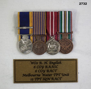
Award - MEDAL SET, Post WW2
Re. W.O. 2 R.M. ENGLISH\ 6 Coy R.A.A.S.C. 6 Coy R.A.C.T. Melb Water TPT Unit 15 TPT SQD R.A..C.T.Medal set, miniature, court mounted, wt of (4) Re R. ENGLISH. 1. Reserve Force Medal with one clasp 2. National Medal 3. Defence Medal 4.Anniversary of National Service Medal 1951 - 1972medals, military, history, passchendaele barracks trust -
Glenelg Shire Council Cultural Collection
Document - Export List, 1939-1973
Vanda Savill, Bower Bird Museum, Heywood 'Dear Friends' servesport of portland -
Glenelg Shire Council Cultural Collection
Pamphlet - Pamphlet - What's on in Portland Tourist Guide, Mar-72
Two copies of 'What's on in Portland', tourist guide, including map of portland with historic buildings marked. Also advertising 'Back to Portland March 3 - 13 1972' a. pink paper, black print. b. yellow paper, black print. -
 Kiewa Valley Historical Society
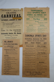
Papers - Tawonga Sports Day & Mt Beauty Carnival
Tawonga and Mt Beauty are in the Kiewa Valley and are attractive tourist destinations. The local clubs such as 'Apex' advertised and conducted programs to involve the locals and tourists and to raise moneyIn the 1960s and 1970s the Kiewa Valley held Carnivals during the Xmas school holidays. The posters list the events and entertainment for the community and visitors. Noticeably different to events held in the 2020s.1.Two Yellowed papers (posters) each titled Tawonga Sports Day - 1972 and 1977 2. Mount Beauty Gigantic Carnival 1960 and another yellowed paper (poster) advertising Mt Beauty over the Xmas Holidays (no date)tawonga sports day program, mt beauty carnival, holiday programs -
 Bendigo Historical Society Inc.
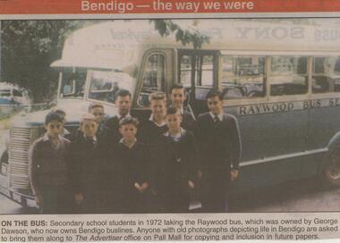
Newspaper - JENNY FOLEY COLLECTION: ON THE BUS
Bendigo Advertiser ''The way we were'' from Friday, December 19, 2003. On the bus: secondary school students in 1972 taking the Raywood bus, which was owned by George Dawson, who now owns Bendigo Buslines. The clip is in a folder.newspaper, bendigo advertiser, the way we were -
 National Vietnam Veterans Museum (NVVM)
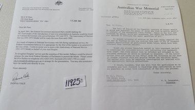
Medal, Roll of Honour - Anniversary of national Service Medal
Roll of Honour Memorial information accuracy request Official (copy) letter from Minister For Veterans Affairs notifying issue in 2002 of a Medal for National Servicemen who served between 1951 - 1972 to the family of Pte Douglas Brian PlainAustralian War Memorial - W.R. Lawrence (Director). Minister For Veterans Affairs - Danna Valemedals, pte plain, veterans affairs, australian war memorial