Showing 2824 items matching "c.c.45"
-
 Federation University Historical Collection
Photograph, Ballarat School of Mines Associates Board 1951-1957, c1984
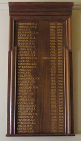
In the early 1880s the Ballarat School of Mines Council introduced a three year course of training under the professors to qualify students in the following professions: 1. Mining Engineering 2. Metallurgy 3. Geology 4. Electricity [45] Each of these courses had an additional, but optional, fourth year of study. The prescribed subjects of study for an Associateship was set out in the Calendar of the Ballarat School of Mines in each year. Any student who passed the prescribed examinations in any of the above courses was issued with a Certificate of Competency, and conferred with the distinction of Associate. By the 1890s the professorial staff had drawn up a curriculum leading to an Associateship of the Ballarat School of Mines. The first two years work was to be common to all courses, but in the third and subsequent years the student wold be devoted to a specialised branch of study. The Associateship was to be conferred in one of another of the following Courses: Agriculture, Civil Engineering, Electrical Engineering, [Geology], Metallurgy and Mining Engineering. All were three year courses except for Agriculture which was two years. Each course was conducted in accordance with a prescribed curriculum and syllabus. During the 1910s there was an expectation that candidates for the Associate course should have attained the age of sixteen, and have received preparatory training equivalent to University Matriculation at least in the subjects of Elementary Mathematics, English Grammar and Composition, or have passed through Junior Technical School. In 1960 an new procedure for admission to graduate status as Associates was introduced to the Ballarat School of Mines where Associateship would be conferred at a public ceremony. After 01 July 1976 graduates of Ballarat College of Advanced Education and Ballarat College of Advanced Education were admitted in major studies relating to mining for Australian accreditation and overseas purposes. Ballarat School of Mines Associates could ascribe ASMB after their name.Black and white photograph of Associatedsof the Ballarat School of Mines from 1951-1957.Associates of the Ballarat School of Mines :Lists names 1989-1964ballarat school of mines, smb campus, electrical engineering 1958, brian w. schreenan civil engineering 1958, clifford j. restarick metallurgy 1958, john t h. clelland metallurgy 1958, donald c. stevens mining engineering 1958, john g. wolfe civil engineering 1959, james e. mcneil electrical engineering 1959, patrick h. nally civil engineering 1959, graham j. willey metallurgy 1959, stanley p. kisler civil engineering 1959, donald j. overall electrical engineering 1959, brian j. mclennan civil engineering 1959, philip j. davis art 1959, bruce v. mcdougall mining engineering 1959, lancelot j. matthews mechanical engineering 1959, alan w. wilson mechanical engineering 1959, alan w. wilson electrical engineering 1959, george a r. lewis art 1959, noel e. meagher electrical engineering 1960, john l. collier mining engineering 1960, john l. collier civil engineering 1960, frank andrewartha mechanical engineering 1960, norman leckie art 1960, lansell j. groat civil engineering 1960, boon thiam lu mining engineering 1960, oswyn n. hails civil engineering 1960, john a. watts applied chemistry 1960, thomas b. gallagher civil engineering 1960, brian a. bellingham civil engineering 1961, alan c leviston applied chemistry 1961, walter j wynd civil engineering 1961, francis d benjamin civil engineering 1961, leonard e fox mechanical engineering 1961, yan kai chung applied chemistry 1961, george d mcgrath mechanical engineering 1961, john r sawyer mechanical engineering 1961, ronald horgan applied chemistry 1961, douglas j vendy civil engineering 1961, john a barnes electrical engineering 1961, brian w smith metallurgy 1961, william r carlyon metallurgy 1961, chris p livitsanos metallurgy 1961, lawrence g trevan civil engineering 1961, richard g dunlop mechanical engineering 1961, ronald m ingleton mechanical engineering 1961, peter m robinson mechanical engineering 1961, david j jelbart mechanical engineering 1961, john g hollway mechanical engineering 1961, george m hetherington civil engineering 1961, david w brown mechanical engineering 1961, john r gowan civil engineering 1961, geoffrey a christian civil engineering 1961, arthur c burrow mechanical engineering 1961, john n mcarthur applied chemistry 1961, graeme r bromley mechanical engineering 1961, william davison civil engineering 1961, ben a johnson electrical engineering 1961, ben a johnson civil engineering 1961, allan j tinney civil engineering 1961, thomas h j coad applied chemistry 1961, brian h duthie civil engineering 1961, basil c bautovich mechanical engineering 1961, reece pullen electrical engineering 1961, john d carmichael electrical engineering 1961, william j spencer civil engineering 1961, neil a brogden civil engineering 1961, michael villani civil engineering 1961, ralph j hepburn mechanical engineering 1961, peter w linaker mechanical engineering 1961, peter j matthews mechanical engineering 1961, edgar mca bartrop mining engineering 1961, donald j stewart, brian schreenan -
 Wodonga & District Historical Society Inc
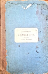
Document - House Creek School 2266 Inspector's Register Book 1881 - 1905
This folder contains the official Inspector's reports for House Creek School Number 2266. Inspections were carried out every six months for all Victorian Government Schools. On 8th October 1879 Mathew Parnaby and others applied for the establishment of a school, between Huon and House Creeks, about four miles southwest of Wodonga. The District Inspector approved and Albert Schlink offered two acres of freehold land as a site, four chains from the southeast corner of Allotment Eight, Section 10, of the Parish of Wodonga in the County of Bogong. A portable classroom, 22ft x14ft, with quarters was erected at a total cost of £192, and SS2266 opened on 1st of June 1880 with Edwin Davis as Head Teacher. In 1883 the average attendance ranged between 12 and 20. Both school and quarters fell into a very bad state of repair. Temporarily closed in 1894, the school reopened as a result of a petition by Ferdinand Godde and others. By 1902 the school had a nett enrolment of 37, the grounds had been fenced, and a shelter shed erected by local effort. By 1907 the nett enrolment had risen to 45 with an average attendance of 37. Ferdinand V. Godde served as Correspondent of the Committee in 1911. House Creek was unstaffed in February 1917 and closed on 8th of November 1917. It reopened on 4th August 1921, but with a nett enrolment of 6, closed on the 24th July 1926. The building was sold for removal. Many of the reports in this Register were written and signed by Henry Finch Rix. He was a pioneer of the Victorian School Inspection System and from 1884 to 1887 worked as a Chief Inspector in the Beechworth Education District. He had previously played with the Carlton Football Club for one season. Henry Rix was a highly regarded educator and a staunch advocate of the establishment of school libraries to teach children of "the rich stores of profitable pleasure to be found in books."This item is significant because it documents progress and recommendations for students at an early government primary school in the Wodonga district.A large bound folder of printed forms. The majority have been completed in handwritten reports including names, notes and statistics. On cover: INSPECTOR'S REGISTER BOOK STATE SCHOOLShenry finch rix, house creek school, victorian school inspectors, school 2266 -
 Bendigo Historical Society Inc.
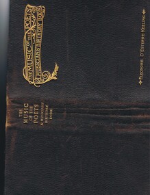
Document - 'MUSICIANS' BIRTHDAY BOOK' OF GEORGE LIDDELL, 1897-1985+
'Musicians' Birthday Book' of George Liddell (music school, Long Gully?) with associated documents. A. 'The Music of the Poets - A Musicians' Birthday Book' 356 pages with music extracts and text on LH side of page; space for birthday information on RH side of each opening page. Printed by Walter Scott Ltd. London and compiled (author?) by Eleonore D'Estrerre-Keeling; 2nd Edition. Inscription on (first) page - 'To Mr. George Liddell With Jack H. Bryant's best wishes for your birthday 1905'. Also on this page (handwritten) and Title Page: Mr H Lofts 16 Tait St Footscray W11. Also (attached to back of front cover) an envelope inscribed 'For Gentlemen Only - Ladies are particularly requested not to look' (card inside!!). Attached to frontispiece (glued) is Hotel Shamrock letter-headed sheet with signatures of Ada Crossley Muecke and Francis F. Muecke. On last page is Photograph of 'Madame Ada Crossley' with signature over of Ada Crossley Muecke'. Within the book are approximately 110 names/signatures set according to date of birth date throughout year. b. Envelope and letter to Mrs Galloway, Moe from John Barry, Manager, Shamrock Hotel, Bendigo, July 1985 re directing of the book to Bendigo (45 View St); c. Note; family history and information re Liddell family (researched by??); d. Note: handwritten in ink - 'for Mulke read McCachie?' and 'Liddell - Music School in Long Gully'person, individual, musician -
 University of Melbourne, Burnley Campus Archives
Photograph - Black and white and colour prints, Information Branch Victorian Department of Agriculture, Staff, 1981-1984
Staff: (3) Lucy Connop (4) Wendy Jones (8) John Billing (15) Margaret Fogarty (16 Megan Donald (17) John Philp (18) Jenny Leereveld (19) Sue Berkeley (20) Mark Hagell (28) Philip Moyle (29) Danny Cotter (30) Gabrielle Vivian-Smith (31) Sally Williams (32) Stuart Portbury (33) Phil Tulk (34) Jeremy Wallace (35) Veneta Grivas (36) Patrick Howden (37) Marion Hill (38) Jayne Lindholm (39) Marian Verhooght (40) Cathy Morley (42) Russell Benallack (43) Paul Rebeschini (44) Jim Pleasance (45) Jim Wood (46) Peter Rumble (47) Jolyon Burnett (48) Lynn M. Burnett (49) Paul A. Elliot (50) Ivo Dean (51) Maria Malzone (52) Hans Frederic (53) Anthony W. Meagher (54 John W. Patrick (56) John L. Patience (61) Geoff Olive (62) Robert M. Hardie (63) Daryl Jowett (64) Dirk van Velzen ((66) Pamela Tumath (69) Darryl Cubbs (70) Jim Pleasance (81) Fred Helregal 01.0801984 (82) Staff group (83) V.C.A.H. Burnley Open day Staff at a stand (84) Graduation group (85) Graduation speaker (86) Graduation-tree planting (89-92) VCAH stamp 2/84 (95) VCAH stamp 2/84 (96) Peter Oppenheimer and student 1981 Dept of Agriculture stamp.staff, lucy connop, wendy jones, john billing, margaret fogarty, megan donald, john philp, jenny leereveld, sue berkeley, mark hagell, philip moyle, danny cotter, gabrielle vivian-smith, sally williams, stuart portbury, phil tulk, jeremy wallace, veneta grivas, patrick howden, marion hill, jayne lindholm, marian verhooght, cathy morley, russell benallack, paul rebeschini, jim pleasance, jim wood, peter rumble, jolyon burnett, lynn m. burnett, paul a. elliot, ivo dean, maria malzone, hans frederic, anthony w. meagher, john w. patrick, john l. patience, geoff olive, robert m. hardie, daryl jowett, dirk van velzen, pamela tumath, darryl cubbs, fred helregal, open day, graduation, tree planting, vcah, peter oppenheimer -
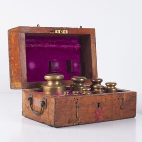 City of Greater Bendigo - Civic Collection
Instrument - Weights and Measures, Troy Weight Set, c 1865
Troy weight is a system of units of mass from an unknown origin. While the name Troi is believed to have come from Troyes in the north east of France the system used primarily in the precious metals industry and adopted in Australia originated in 15th century England. Troy weight units are the 'grain' and 'pennyweight' (24 grains), the troy ounce (20 pennyweights), and the troy pound (12 troy ounces). One troy ounce equals 31.1034768 grams. The troy ounce and grain were also part of the apothecaries' system and was long used in medicine, but has now been largely replaced by the metric system (milligrams). When the Weights and Measures Act was passed in Victoria in 1862 local inspectors were established throughout the colony to ensure accuracy particularly in the weighing of gold. By the 1870's each local council had a set of standards that were used to test the scales, weights and measures of local merchants and businesses. This set would have been de commissioned some time after 1947 and was offered back to the Borough of Eaglehawk in 1989. Hinged, lockable wooden box with brass handle, hinges, latches and lock. Remnant wax on front face of box above and below lock. Interior of box is lined with purple velvet which is worn in several places. Box houses nine troy weights ranging in size from 100oz Troy to 2oz Troy. 1oz Troy is missing. Accompanying set is a two page letter from Weights and Measures Branch of Consumer Affairs offering set back to the Borough of Eaglehawk in 1989. Troy Weights: Part a) 100oz Weight, 68 mm Diameter at base x 113 mm H b) 50 oz Weight, 53 mm D x 90 mm H c) 30 oz Weight, 45 mm D x 77 mm H d) 20 oz Weight, 39 mm D x 65 mm H e) 16 oz Weight, 37 mm D x 60 mm H f) 8 oz Weight, 30 mm D x 47 mm H g) 4 oz Weight, 24mm D x 36 mm H h) 2 oz Weight, 19mm D x 28 mm H i) 1oz missing Hinged Wooden Box: Part j)171 mm H x 300mm W x 196 mm D Typed two page letter: Part k) 295 mm H x 210 mm W x 1 mm Top Troy: Each Troy weight stamped with small symbol made up of the number 5, an image of a crown and the word STANDARD. Side Troy : Each Troy weight stamped with small symbol made up of the number 5, an image of a crown and the word STANDARD above a series of date stamps recording every time the weight was tested. Date stamps: 30.4.1866; 16.9.81, 30 12.86; 1.2.92; 10.5.97; 15.1.04; 10.2.09; 17.12.14; 20.4.20; 29.9.25; 23.1.31; 18.6.36; 14.7.41: 11.7.47 Exterior Top of Box: Remnant of paper pasted to wood. Faint printed text 'ON HIS MAJESTY'S SERVICE'.borough of eaglehawk, making a nation exhibition, city of greater bendigo commerce -
 Bendigo Historical Society Inc.
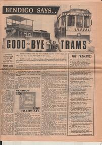
Document - BASIL MILLER COLLECTION: BENDIGO SAYS GOOD-BYE TO THE TRAMS, c1972
13 April 1972. Bendigo Says Good-bye to the Trams. A1 sheet - double sided. Tramway history 1890 - 1972, 2 copies. At the stroke of 5 pm from Eaglehawk Town Hall clock 82 years of history will end as the last tram makes its sentimental journey to the city, while at the Bendigo Cemetery - the Quarry Hill line terminus - another tram will be leaving for its last resting place. Other articles include: Four Eras, of trams. The Trammies, covering Ballarat, Geelong in the form of a poem. 1927 and all that, by Basil Miller, remembering his 45 years of service with the trams. How it all started, The twin communities of Sandhurst and Eaglehawk were relatively early in considering the possibility of operating street tramways within their boundaries. Cabs, Battery Cars, Construction, Strikes, Bendigo 1890 to 1972 - Tramways. Man and his Mates, continued from previous page, Explosion, Touchy Task, A Quickey, Horrors. Electric in 1903, There was excitement galore in the City during April, 1903 - and the Advertiser recorded the progress of the new-fangled electric machine. One man's Memories, Tough times, humour, tragedy and comradeship - they all came flooding back as former Bendigo tramway-man Tom Griffiths recently turned the clock back. Keb Sir Keb Sir? 'Keg sir? Tram off the line,' was the call of the cabbies when a train pulled in at the Bendigo railway station. Altered Shopping Trend, With advent of the electric tram in Bendigo came change in shopping habits.bendigo trams -
 Bendigo Historical Society Inc.
Map - Laminated map of Lake Eppalock at full capacity
John Perry Collection. Laminated copy of map of Lake Eppalock at full capacity. Had highlighter markings of old roads which appear to be still in use. The dam was built by the State Rivers and Water Supply Commission of Victoria. The dam wall height is 45 metres (148 ft) and the main embankment is 1,041 metres (3,415 ft) long. At 100% capacity the dam wall was designed to hold back 304,651 megalitres (6.7014×10¹⁰ imp gal; 8.0480×10¹⁰ US gal) of water. The surface area of Lake Eppalock is 3,011 hectares (7,440 acres) and the catchment area is 2,124 square kilometres (820 sq mi). The controlled spillway is capable of discharging 8,040 cubic metres per second (284,000 cu ft/s). Lake Eppalock supplies both stock and domestic water to the Campaspe irrigation district. It also serves as a water supply to Bendigo and Heathcote and, in more recent times, Ballarat. The lake is a major attraction for those engaging in watersports, with a number of tourist parks and accommodation facilities available. Permissible activities on the lake include high-speed boating, water skiing, sailing, canoeing, fishing and swimming. The lake's water levels were low for approximately eight years between 2002 and 2010 during a prolonged drought, which restricted the amount of recreational activity until rainfall in the latter half of 2010 returned the lake to 100 percent capacity. Built between 1961 and 1964, Lake Eppalock remains the only water storage on the Campaspe River system.map, water, dam, reservoir, eppalock -
 Bendigo Historical Society Inc.
Map - Laminated worksheet - identification of inundated artifacts at Lake Eppalock
John Perry Collection. Laminated copy of worksheet identifying inundated artifacts at Lake Eppalock when at 10% capacity. The dam was built by the State Rivers and Water Supply Commission of Victoria. The dam wall height is 45 metres (148 ft) and the main embankment is 1,041 metres (3,415 ft) long. At 100% capacity the dam wall was designed to hold back 304,651 megalitres (6.7014×10¹⁰ imp gal; 8.0480×10¹⁰ US gal) of water. The surface area of Lake Eppalock is 3,011 hectares (7,440 acres) and the catchment area is 2,124 square kilometres (820 sq mi). The controlled spillway is capable of discharging 8,040 cubic metres per second (284,000 cu ft/s). Lake Eppalock supplies both stock and domestic water to the Campaspe irrigation district. It also serves as a water supply to Bendigo and Heathcote and, in more recent times, Ballarat. The lake is a major attraction for those engaging in watersports, with a number of tourist parks and accommodation facilities available. Permissible activities on the lake include high-speed boating, water skiing, sailing, canoeing, fishing and swimming. The lake's water levels were low for approximately eight years between 2002 and 2010 during a prolonged drought, which restricted the amount of recreational activity until rainfall in the latter half of 2010 returned the lake to 100 percent capacity. Built between 1961 and 1964, Lake Eppalock remains the only water storage on the Campaspe River system.map, artifacts, eppalock, reservoir -
 Bendigo Historical Society Inc.
Map - Black and white map pertaining to Lake Eppalock
John Perry Collection. Laminated copy of map pertaining to Lake Eppalock. Gives details of dwellings, bridges and ford crossings. The dam was built by the State Rivers and Water Supply Commission of Victoria. The dam wall height is 45 metres (148 ft) and the main embankment is 1,041 metres (3,415 ft) long. At 100% capacity the dam wall was designed to hold back 304,651 megalitres (6.7014×10¹⁰ imp gal; 8.0480×10¹⁰ US gal) of water. The surface area of Lake Eppalock is 3,011 hectares (7,440 acres) and the catchment area is 2,124 square kilometres (820 sq mi). The controlled spillway is capable of discharging 8,040 cubic metres per second (284,000 cu ft/s). Lake Eppalock supplies both stock and domestic water to the Campaspe irrigation district. It also serves as a water supply to Bendigo and Heathcote and, in more recent times, Ballarat. The lake is a major attraction for those engaging in watersports, with a number of tourist parks and accommodation facilities available. Permissible activities on the lake include high-speed boating, water skiing, sailing, canoeing, fishing and swimming. The lake's water levels were low for approximately eight years between 2002 and 2010 during a prolonged drought, which restricted the amount of recreational activity until rainfall in the latter half of 2010 returned the lake to 100 percent capacity. Built between 1961 and 1964, Lake Eppalock remains the only water storage on the Campaspe River system.eppalock, map, water, dam, reservoir -
 Bendigo Historical Society Inc.
Map - Map of overlay of lake Eppalock at full capacity. Map 'C'
John Perry collection. Map 'C'. Laminated map of overlay of Lake Eppalock at full capacity. Circa 1951. The dam was built by the State Rivers and Water Supply Commission of Victoria. The dam wall height is 45 metres (148 ft) and the main embankment is 1,041 metres (3,415 ft) long. At 100% capacity the dam wall was designed to hold back 304,651 megalitres (6.7014×10¹⁰ imp gal; 8.0480×10¹⁰ US gal) of water. The surface area of Lake Eppalock is 3,011 hectares (7,440 acres) and the catchment area is 2,124 square kilometres (820 sq mi). The controlled spillway is capable of discharging 8,040 cubic metres per second (284,000 cu ft/s). Lake Eppalock supplies both stock and domestic water to the Campaspe irrigation district. It also serves as a water supply to Bendigo and Heathcote and, in more recent times, Ballarat. The lake is a major attraction for those engaging in watersports, with a number of tourist parks and accommodation facilities available. Permissible activities on the lake include high-speed boating, water skiing, sailing, canoeing, fishing and swimming. The lake's water levels were low for approximately eight years between 2002 and 2010 during a prolonged drought, which restricted the amount of recreational activity until rainfall in the latter half of 2010 returned the lake to 100 percent capacity. Built between 1961 and 1964, Lake Eppalock remains the only water storage on the Campaspe River system.map, water, eppalock, dam, reservoir -
 Bendigo Historical Society Inc.
Map - Laminated map of Lake Eppalock empty. Map 'D'
John Perry Collection. Laminated map of Lake Eppalock empty. Map 'D'. Circa 1951. The dam was built by the State Rivers and Water Supply Commission of Victoria. The dam wall height is 45 metres (148 ft) and the main embankment is 1,041 metres (3,415 ft) long. At 100% capacity the dam wall was designed to hold back 304,651 megalitres (6.7014×10¹⁰ imp gal; 8.0480×10¹⁰ US gal) of water. The surface area of Lake Eppalock is 3,011 hectares (7,440 acres) and the catchment area is 2,124 square kilometres (820 sq mi). The controlled spillway is capable of discharging 8,040 cubic metres per second (284,000 cu ft/s). Lake Eppalock supplies both stock and domestic water to the Campaspe irrigation district. It also serves as a water supply to Bendigo and Heathcote and, in more recent times, Ballarat. The lake is a major attraction for those engaging in watersports, with a number of tourist parks and accommodation facilities available. Permissible activities on the lake include high-speed boating, water skiing, sailing, canoeing, fishing and swimming. The lake's water levels were low for approximately eight years between 2002 and 2010 during a prolonged drought, which restricted the amount of recreational activity until rainfall in the latter half of 2010 returned the lake to 100 percent capacity. Built between 1961 and 1964, Lake Eppalock remains the only water storage on the Campaspe River system.map, water, dam, reservoir, eppalock -
 Bendigo Historical Society Inc.
Document - Legend to maps A, B and C for Lake Eppalock
John Perry Collection. Laminated 'legend' for Maps A, B and C for Lake Eppalock also in this collection. Black and White definitions and descriptions of objects and markers found on maps. Circa 1951. The dam was built by the State Rivers and Water Supply Commission of Victoria. The dam wall height is 45 metres (148 ft) and the main embankment is 1,041 metres (3,415 ft) long. At 100% capacity the dam wall was designed to hold back 304,651 megalitres (6.7014×10¹⁰ imp gal; 8.0480×10¹⁰ US gal) of water. The surface area of Lake Eppalock is 3,011 hectares (7,440 acres) and the catchment area is 2,124 square kilometres (820 sq mi). The controlled spillway is capable of discharging 8,040 cubic metres per second (284,000 cu ft/s). Lake Eppalock supplies both stock and domestic water to the Campaspe irrigation district. It also serves as a water supply to Bendigo and Heathcote and, in more recent times, Ballarat. The lake is a major attraction for those engaging in watersports, with a number of tourist parks and accommodation facilities available. Permissible activities on the lake include high-speed boating, water skiing, sailing, canoeing, fishing and swimming. The lake's water levels were low for approximately eight years between 2002 and 2010 during a prolonged drought, which restricted the amount of recreational activity until rainfall in the latter half of 2010 returned the lake to 100 percent capacity. Built between 1961 and 1964, Lake Eppalock remains the only water storage on the Campaspe River system.map, water, dam, reservoir, eppalock -
 Bendigo Historical Society Inc.
Document - Collection of photographs from newspaper on a single page
John Perry Collection. Laminated copy of page from 'Weekly Times' newspaper, February, 1962. Nine images relating to establishing and building Eppalock Reservoir, 15 miles from Bendigo. The dam was built by the State Rivers and Water Supply Commission of Victoria. The dam wall height is 45 metres (148 ft) and the main embankment is 1,041 metres (3,415 ft) long. At 100% capacity the dam wall was designed to hold back 304,651 megalitres (6.7014×10¹⁰ imp gal; 8.0480×10¹⁰ US gal) of water. The surface area of Lake Eppalock is 3,011 hectares (7,440 acres) and the catchment area is 2,124 square kilometres (820 sq mi). The controlled spillway is capable of discharging 8,040 cubic metres per second (284,000 cu ft/s). Lake Eppalock supplies both stock and domestic water to the Campaspe irrigation district. It also serves as a water supply to Bendigo and Heathcote and, in more recent times, Ballarat. The lake is a major attraction for those engaging in watersports, with a number of tourist parks and accommodation facilities available. Permissible activities on the lake include high-speed boating, water skiing, sailing, canoeing, fishing and swimming. The lake's water levels were low for approximately eight years between 2002 and 2010 during a prolonged drought, which restricted the amount of recreational activity until rainfall in the latter half of 2010 returned the lake to 100 percent capacity. Built between 1961 and 1964, Lake Eppalock remains the only water storage on the Campaspe River system. dam, engineering, water, eppalock -
 Bendigo Historical Society Inc.
Map - Black and White map. Outline of Lake Eppalock. Map 'B'
John Perry Collection. Laminated copy black and white map. Map 'B'. Outline of Lake Eppalcok, overlayed on map. Circa 1951. The dam was built by the State Rivers and Water Supply Commission of Victoria. The dam wall height is 45 metres (148 ft) and the main embankment is 1,041 metres (3,415 ft) long. At 100% capacity the dam wall was designed to hold back 304,651 megalitres (6.7014×10¹⁰ imp gal; 8.0480×10¹⁰ US gal) of water. The surface area of Lake Eppalock is 3,011 hectares (7,440 acres) and the catchment area is 2,124 square kilometres (820 sq mi). The controlled spillway is capable of discharging 8,040 cubic metres per second (284,000 cu ft/s). Lake Eppalock supplies both stock and domestic water to the Campaspe irrigation district. It also serves as a water supply to Bendigo and Heathcote and, in more recent times, Ballarat. The lake is a major attraction for those engaging in watersports, with a number of tourist parks and accommodation facilities available. Permissible activities on the lake include high-speed boating, water skiing, sailing, canoeing, fishing and swimming. The lake's water levels were low for approximately eight years between 2002 and 2010 during a prolonged drought, which restricted the amount of recreational activity until rainfall in the latter half of 2010 returned the lake to 100 percent capacity. Built between 1961 and 1964, Lake Eppalock remains the only water storage on the Campaspe River system.map, water, dam, reservoir, eppalock -
 Bendigo Historical Society Inc.
Map - Black and white map pertaining to Lake Eppalock
John Perry Collection. Laminated copy of map relating to Lake Eppalock. Lists dwellings, ford crossings and bridges. The dam was built by the State Rivers and Water Supply Commission of Victoria. The dam wall height is 45 metres (148 ft) and the main embankment is 1,041 metres (3,415 ft) long. At 100% capacity the dam wall was designed to hold back 304,651 megalitres (6.7014×10¹⁰ imp gal; 8.0480×10¹⁰ US gal) of water. The surface area of Lake Eppalock is 3,011 hectares (7,440 acres) and the catchment area is 2,124 square kilometres (820 sq mi). The controlled spillway is capable of discharging 8,040 cubic metres per second (284,000 cu ft/s). Lake Eppalock supplies both stock and domestic water to the Campaspe irrigation district. It also serves as a water supply to Bendigo and Heathcote and, in more recent times, Ballarat. The lake is a major attraction for those engaging in watersports, with a number of tourist parks and accommodation facilities available. Permissible activities on the lake include high-speed boating, water skiing, sailing, canoeing, fishing and swimming. The lake's water levels were low for approximately eight years between 2002 and 2010 during a prolonged drought, which restricted the amount of recreational activity until rainfall in the latter half of 2010 returned the lake to 100 percent capacity. Built between 1961 and 1964, Lake Eppalock remains the only water storage on the Campaspe River system.map, water, dam, reservoir, eppalock -
 Bendigo Historical Society Inc.
Map - General view of area of proposed construction of Lake Eppalock. Map 'A'
John Perry Collection. Laminated map of proposed construction of Lake Eppalock. Map 'A'. Black and white map in laminate. Circa 1951. The dam was built by the State Rivers and Water Supply Commission of Victoria. The dam wall height is 45 metres (148 ft) and the main embankment is 1,041 metres (3,415 ft) long. At 100% capacity the dam wall was designed to hold back 304,651 megalitres (6.7014×10¹⁰ imp gal; 8.0480×10¹⁰ US gal) of water. The surface area of Lake Eppalock is 3,011 hectares (7,440 acres) and the catchment area is 2,124 square kilometres (820 sq mi). The controlled spillway is capable of discharging 8,040 cubic metres per second (284,000 cu ft/s). Lake Eppalock supplies both stock and domestic water to the Campaspe irrigation district. It also serves as a water supply to Bendigo and Heathcote and, in more recent times, Ballarat. The lake is a major attraction for those engaging in watersports, with a number of tourist parks and accommodation facilities available. Permissible activities on the lake include high-speed boating, water skiing, sailing, canoeing, fishing and swimming. The lake's water levels were low for approximately eight years between 2002 and 2010 during a prolonged drought, which restricted the amount of recreational activity until rainfall in the latter half of 2010 returned the lake to 100 percent capacity. Built between 1961 and 1964, Lake Eppalock remains the only water storage on the Campaspe River system.map, dam, water, weir, eppalock -
 Kiewa Valley Historical Society
Photographs and copies of photographs of the pack horses and early horsemen who transported supplies to outposts in the Bogong High Plains, via cattle tracks before access roads were made
In the mid to late 1930’s survey outposts were established to plot the early stages of the Kiewa Hydro Electric System for the SECV in the Bogong High Plains. Before any roads were built, the old cattleman’s tracks were used with packhorses to deliver supplies, wages and mail and collect timesheets and correspondence from the workmen and dam builders living in canvas tents and at the outlying survey posts. The trip up the mountain was long and hard and dangerous for both horse and man Most of the men of the survey teams were not bush-men and were often ill equipped for the harsh weather and living conditions of bush camping, often arriving in their city clothes ready for work. The tent city at Bogong was destroyed by bush fires in 1939 after which an access road was built from Mt Beauty to transport building materials for more permanent dwellings for workmen. Pack horses continued to be used for transporting goods etc. to workers further up the mountain.Without the work of horsemen and their pack horses providing supplies and communications for outlying outposts, surveying and early planning for the Kiewa Valley Hydro Electric scheme could not have gone ahead and the dams and power stations which support the system could not have been constructed. The Hydro-electric scheme, and the workers who planned and built it play a major part in the early history of the Kiewa Valley and many original families still remain living, or have ties with the local area.: Set of 21 black and white photographs and copies of photographs depicting the pack horses and the men who handled them, transporting supplies and correspondence to the outlying camps and survey posts in the Bogong High Plains, via the rough cattlemen’s tracks. Photographs also show the early tent camps of the workers. Some photos mounted on A4 white paper. Some photos enlarged to A3 poster size for display1. Handwritten on back – Max Lawrence 2. -8 No inscriptions 9. Handwritten on back- Packing in supplies for early workers of the Kiewa Hydro scheme. There were no roads in the early days of the scheme 10. Printed on bottom of photo- Roper’s cattle on road below Howman’s Gap 11. Handwritten on back – Roper’s et al about to leave for the high plains 12. Printed under photo- Syd Ryder at the Pretty Valley Cut-Out (JBR) 13-16. No markings 17. Printed under photo- Gwen Talbot visits the Camp area. 1937 18. Handwritten on back- 14/1 Barbara Talbot 19. No markings 20-21. No markings 22. Printed under photo- STATE ELECTRICITY COMMISSION OF VICTORIA. Date: 15-3-45 Time: 8.0pm No: K 1838 Kiewa Hydro-Electric Works, Investigations 1944-1945 – Survey Camp at Young’s Hut pack horses; bogong high plains; survey posts; supplies delivery -
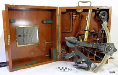 Flagstaff Hill Maritime Museum and Village
Instrument - Navigational Sextant, 1882-1890
A sextant is an astronomical instrument used to determine latitude and longitude at sea by measuring angular distances, especially the altitudes of the sun, moon, and stars. It is a doubly reflecting navigation instrument and used mainly by sailors to measure the angular distance between two visible objects. The name comes from the Latin sextans, or “sixth part of a unit,” because the sextant’s arc can be 60° or 120° of a circle depending on the model used. The primary use was to measure the angle between an astronomical object and the horizon for the purposes of celestial navigation. The estimation of this angle is known as sighting or shooting the object, or taking a sight. This angle and the time when it was measured is used in order to determine Greenwich Mean Time and hence longitude. Sighting the height of a landmark on land can also give a measure of distance from that object. History: The development of the sextant was as an improvement over the octant, an instrument designed to measure one's latitude. The octant was first implemented around 1731-present but can only measure angles up to 45°. As larger angles were needed to allow the measurement of lunar objects - moon, stars and the sun - at higher angles, the octant was superseded by the sextant. The sextant is a similar instrument but better made and allows larger angles from 60° to 120°. This improvement allows distances to be accurately calculated thereby giving longitude when used with a chronometer. The sextant was derived from the octant in 1757, eventually making all previous instruments used for navigational positioning obsolete. The sextant had been attributed to by John Hadley (1682–1744) and Thomas Godfrey (1704–1749), but reference to the sextant was also found later in the unpublished writings of Isaac Newton (1643–1727). Earlier links can be found to Bartholomew Gosnold (1571–1607) indicating that the use of a sextant for nautical navigation predates Hadley's implementation. In 1922, the sextant was modified for aeronautical navigation by Portuguese navigator and naval officer Gago Coutinho. It should be noted that the octant and quadrant are in the same family as they were, and all are, regarded as sextants. The sextant is representative of it's type and although not fully complete it demonstrates how 18th,19th and 20th century mariners determined their latitude and longitudinal to determine their position on a chart, allowing them to navigate there way across the world's oceans. It also demonstrates the skill and workmanship of the early instrument makers that operated scientific instrument businesses from London and other areas of England to provide most of the navigational instrumentation used by commercial and military navies of the time.Sextant with square, fitted box of polished wood, "Hezzanith" brand. Box contains many parts for the sextants use. On certificate "Heath & Co, London. Sextant Number Y 822". Catch on lid "DEFIANT LEVER" and "PATENT NUMBER 187.10". Maker's certificate is attached to the inside of the box.flagstaff hill, warrnambool, shipwrecked-coast, flagstaff-hill, flagstaff-hill-maritime-museum, maritime-museum, shipwreck-coast, flagstaff-hill-maritime-village, sextant box, sextant, hezzanith, heath & co, navigational instrument, george wilson heath, astronomical instrument, instrument manufacturers, scientific instrument, navigation, celestial navigation, octant, quadrant, lunar navigation -
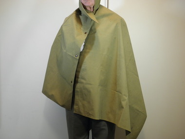 City of Moorabbin Historical Society (Operating the Box Cottage Museum)
Uniform - Armed Services, Cape/groundsheet, 20th century
Rain cape, also used as a groundsheet, issued Australian servicemen. Purchased for the donor from an "Army Surplus" store and re-purposed for camps as a Scout in the late 1960s. The MK VII Groundsheet (Rain Cape / Poncho) was introduced in October 1917 during WW1. They were made from dyed cotton, proofed with a rubber compound, "well vulcanized" on one side. Weight 3lb. 8oz;. 78 inches long by 36 inches wide and made by the Victoria Rubber Co. Edinburgh. They were used again during WWII 1939-45 Today the Army uses the hootchie - a sheet of 70D nylon or PU-coated cotton with various press snaps and webbing tape loops attached around the outside which allow it to be used in a variety of configuration. During WWII Australian forces fighting the Japanese in the Islands had an urgent requirement for a decent individual shelter. The rubberized canvas groundsheets and rain capes continued to be used, but these were less than effective in the tropics. Towards the end of the war in the Pacific Australia began issuing its troops a lighter weight version of the groundsheet manufactured from polyurethane-coated cotton – During the Malayan Emergency of the 1950s, Australian troops were issued with hooded ponchos. Unlike the WWII US pattern ponchos which always had a hole in the dead centre of the poncho sheet, the Australian-issue hooded ponchos made an effective shelter – especially when two where clipped together. The problem of course is that the rubberized canvas ponchos were far too heavy for jungle use. 1960s Australian units in Borneo were issued with the first pattern lightweight hootchies. 1 Kg. 1970 the Vietnam War, a second pattern lightweight hootchie was issued made from nylon, but retaining the hardware and loops. This lightweight hootchie weighed a mere 680 grams, still heavy, but suitable for tropical use. Currently the hootchie is made from AUSCAM nylon material . Historic significance; representative of the type believed to have been issued to Australian servicemen in World War II, possibly in World War I.Waterproofed Canvas rain cape, also used as a groundsheet in the Australian Army, press studs to close as a cape, collar to cover neck.NILuniforms, australian army, world war ii, army surplus, scouts australia, bentleigh, moorabbin, world war 1, hooded ponchos, borneo, auscam nylon material, hootchies, malayan emergency, vietnam war, groundsheets -
 Australian Queer Archives
Audio, 2SER 107.3 FM (Radio Station : Sydney, NSW) : Gaywaves : 4/8/1983 : Enola Gay special on disarmament, 1983
Produced for Enola Gay's participation in Hiroshima Day, Sat 6 August 1983, assembling at Belmore Park at 10 am under the Enola Gay banners. 0:00: Introduction and song; 3:50: Japanese instrumental music; 9:08: Commentary resumes - history of the bombing of Hiroshima, 6 Aug 1945, and Nagasaki 3 days later; 15:30: Music Tomorrow never comes until it's too late; 19:45: Commentary including accounts from survivors; 26:58: Music, Take the toys from the boys; 29:25: Commentary regarding arms race, including voice of Fabian LoSchiavo regarding dissident religious views in the USA; 33:05: Music, California dreaming; 36:10: Commentary re the practicalities of bomb shelters; 38:00: Music, Cancer, cancer; 41:40: Commentary re peace marches in Europe, health effects of radiation, civil defense in nuclear war, music; 47:35: Music, Universal soldier (cut off towards end), anti-war parody of Yankee Doodle Uncle Sam with Australian refs (Omega, Pine Gap etc); 59:10: Commentary regarding nuclear bomb testing at Marilinga (SA) and Monte Bello islands; 1:01:15: Music, 'But I aint a marchin' any more'; 1:04:05: Commentary re costs of arms race - refs to gay and feminist anti-war groups overseas; 1:05:58: Music, Down by the riverside/Aint gonna study war no more, promo for Enola Gay and prep for Hiroshima Day, instrumental music, music US forces (Midnight Oil), Soft touch (Poison Girls); 1:26:56: Music, Thank Christ for the bomb, eerie instrumental music, Maralinga (Midnight Oil), Not another bomb song, ending at 1:39:00.Maxwell UD XL I - C90 cassette tapeInscribed in biro on label: "ENOLA GAY Disarmament Special - Gaywaves 2SER 4/8/83."anti-nuclear activism, gay and lesbian activism, hiroshima day -
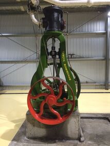 Puffing Billy Railway
Steam Engine - Tangye single cylinder vertical, Circa 1920
Used by the Malvern city council until 1969 to drive a rock crushing plant. While large horizontal steam engines predominated in major factories, small vertical steam engines like this were the workhorses of industries that had modest power requirements. This reliable little engine, made by leading UK manufacturer Tangye Bros of Birmingham Steam engines had the advantage that any fuel could be used to fire their boilers, but they were less convenient and efficient than internal combustion engines, required operators with higher skill levels, and had lower power to weight ratios. Tangye Limited was founded in 1857 in Birmingham by businessman Richard Tangye (1833-1906) and his mechanic brothers James and Joseph; brothers Edward and George joined them later. Richard was born near Redruth in Cornwall and educated at the Friends School at Sidcot, Somerset, where he became a pupil-teacher. From there he moved to Birmingham to work as a clerk for an engineering firm. In 1856 he started a hardware factor and commission agent business in Birmingham whose customers were mainly Cornish mine-owners in the Redruth district. From 1858 Tangyes concentrated on the manufacture of machinery and secured the sole right to manufacture Weston's differential pulley block (object 2003/45/1). They established their Cornwall Works in the Birmingham suburb of Smethwick in 1864 and soon developed a huge range of products. It was stated that 'there are perhaps no other works in the kingdom so largely employed upon so great a variety of specialities as the Cornwall Works of Messrs Tangye Bros.' The Tangyes attracted creative people to work for them. They wrote: 'We are in a position to offer unusual facilities to Inventors for carrying out their patents.' Info about Tangye Bros of Birmingham from Powerhouse Museum https://ma.as/207954 Donated by Malvern City Council in 1969 Of Interest : The Vertical and Horizontal Tangye engines on display are of the design that won a Gold Medallion at the Paris Industrial Exhibition of 1878.Historic - Industrial Steam Engine Equipmentsingle cylinder vertical Steam Engine made of Cast Iron, (Painted)Tangye Birmingham Builder's number 2462tangye, vertical steam engine, steam engine, puffing billy, stone crushing, george and george, malvern -
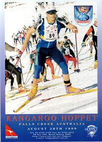 Falls Creek Historical Society
Poster - Kangaroo Hoppet 1999
The Kangaroo Hoppet is Australia’s premier long distance cross country ski race, and a member of the Worldloppet series of international cross country ski events. The first race at Falls Creek was held in 1979 under the name of “Australian Birkebeiner”. It was a 21km race with about 80 participants organised by the Birkebeiner Nordic Ski Club of Mount Beauty. The course started and finished at Falls Creek Alpine Resort and took participants out into the Bogong High Plains. After running the event for 10 years, it was decided they should become part of the Worldloppet series of marathon ski races. Representatives from the Birkebeiner Nordic Ski Club and the Australian Ski Federation attended the Worldloppet Annual Meeting in Finland in June 1990 to put the case for the acceptance of an Australian event into the Worldloppet series. Before being admitted, they had to demonstrate that the Birkebeiner Club could run a world class event, so three months later in August 1990 a 42km event named the Australian International Ski Marathon was held at Falls Creek together with a 21km Birkebeiner race and a 7km event called the Birkebeiner Lite. The event was approved by delegates from USA, Norway and Austria, in 1991 Australia became the 12th member of Worldloppet, with the condition that there had to be a name change. After some late night discussion allegedly involving red wine from North East Victoria the main event became the 42km Kangaroo Hoppet, with the minor events being the 21km Australian Birkebeiner, and 7km Joey Hoppet. In the winter of 1991, the first Kangaroo Hoppet was held. It was a great success and has been a regular fixture on the international ski calendar ever since. It features the main 42km event as well as a 21km event and a 7km event. The Hoppet brings the Australian snowfields to an international audience. In 1999 the Men's Winner was Vitaly Tchernov from Russia in a time of 1:45:26. The winner of the Women's event was Jannike Oeyen of Norway in a time of 1:54:05.This poster is significant because it documents an event which brings international attention to Falls Creek and the surrounding region.A coloured poster featuring an image of a group of Hoppet skiers from 1998 ascending a slope.The logo of Worldloppet is featured in the top left corner. The logos of QANTAS and the KANGAROO HOPPET are in the bottom corners,Across bottom: KANGAROO HOPPET FALLS CREEK AUSTRALIA AUGUST 28th 1999 Tel: (03) 5754 3103 Fax: (03) 5754 4475 P.O. Box 400 Mount Beauty 3699 http://www.netc.net.au/-hoppet/ e-mail: [email protected] hoppet, worldloppet events, falls creek, mt. beauty -
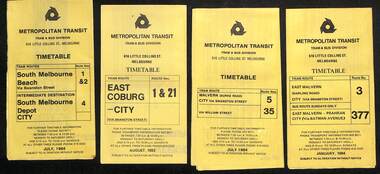 Melbourne Tram Museum
Ephemera - Timetables - Metropolitan Transit - set of 22, Metropolitan Transit Authority (MTA), 1983 and 1984
Timetables - provides information on fare sections and a route map. 1 - Routes 1, 2 & 4 - South Melbourne - City - July 1984 2 - Route 1 & 21 - East Coburg - City August 1983 3 - Route 5 and 35 - Malvern Burke Road - July 1984 4 - Route 3 and 377 - East Malvern (Darling Road) and bus route on Sundays only - Jan. 1984 5 - Route 6, 36 and 7 - Glen Iris - July 1984 6 - Route 8 and 38 - Toorak - June 1984 7 - Route 9 and 14 - Northcote - June 1984 8 - Route 10 & 11, 13 - West Preston - May 1984 9 - Route 15 & 22 - Moreland - July 1983 10 - Route 15 & 16, 53 & 55 - St Kilda Beach - July 1983 11 - Route 19, 20 and 18 (MMTB) - North Coburg - Oct. 1982 12 - Route 42, 23, 44, 45 and 47 - Mont Albert - July 1984 13 - Route 48, 24, 40, 41 and 29 - North Balwyn - Nov. 1983 14 - Route 57, 357, 54, 60, 58 and 50 - West Maribyrnong - bus on Sundays - July 1984 15 - Route 64, 65, 62 and 61 - East Brighton - Jan. 1984 16 - Route 67, 37, and 66 - Carnegie - Jan. 1984 17 - route 70, 71 and 76 - Wattle Park - June 1984 18 - route 75, 74, 76 and 28 - East Burwood - JIan. 1984 19 - route 77, 78 and 79 - Prahran - North Richmond - July 1984 20 - route 82 and 223 - Footscray - Moonee Ponds and bus on Sundays and Saturdays - June 1984 21 - route 88, 14, 89 and 90 - East Preston - July 1983 22 - route 96, 95 and 97 - East Brunswick - July8 1984Yields information about Metropolitan Transit services during the mid 1980s.Set of 22 Metropolitan Transit tram timetables - multifold printed on yellow paper.timetable, metropolitan transit, the met, route 1, route 2, route 4, route 21, route 5, route 35, route 3, route 377, route 6, route 36, route 7, route 8, route 38, route 9, route 14, route 10, route 11, route 13, route 15, route 22, route 16, route 53, route 55, route 19, route 18, route 20, route 42, route 23, route 44, route 45, route 47, route 48, route 24, route 40, route 41, route 29, route 57, route 357, route 54, route 60, route 58, route 50, route 64, route 65, route 62, route 61, route 67, route 37, route 66, route 70, route 71, route 76, route 75, route 74, route 28, route 77, route 78, route 79, route 82, route 223, route 99, route 89, route 90, route 96, route 95, route 97 -
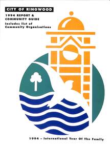 Ringwood and District Historical Society
Book, City of Ringwood, City of Ringwood 1994 Report & Community Guide, 1994
The City of Ringwood and the City of Croydon merged in December 1994 and became the City of Maroondah.Community information book issued by City of Ringwood for 1994 - covering the facilities and activities of the Ringwood Council and other local organisations and associations. Includes Ringwood Public Golf Course discount vouchers and two Ringwood Aquatic Centre bonus entry vouchers.CONTENTS: (page no.) Contents A Message from the Mayor - Cr. Margaret Cheevers 3 Your Council 4 Local State and Federal MPs 5 Council Meetings and Elections 6 History of Ringwood 7 City Manager's Report 8 Organisational structure 9 Human Services 10-19 Environmental Health 20-21 Ringwood Library 22 Parks and Gardens 23 Ringwood's Parks and Reserves 24 Building 25 Engineering Planning Services 26-28 Waste Management 29 Town Planning 30 Traffic and Local Laws 31-33 Roads, Drainage and Major Works 38-39 Halls and Facilities 40-41 Aquatic Centre 42 Convention Centre/Karralika Theatre 43 Golf Course 44 Free Swim & Golf Discount Vouchers 45 Community Organisations 46-64 Finance 65-66 Administration 67 Community Liaison 68 Information Systems 69 Personnel 70-71 Risk Management 71 Rates and Valuations 72 rinx -
 Moorabbin Air Museum
Document (item) - CAC Collection - Various Publications refer Description for further details
Engineering Development Reorganisation Memo From R.C.Beckett December 18 1981. Hawker De Havilland Vic.Ltd Engineering Supplement April 1987. Hawker De Havilland Information Bulletin - Launch Into Space Age 2nd September 1987. A.H.S.A Newsletter Volume 21 Number 1 March 2005 CAC Director's Report For Year Ended 30th September 1966. The Development Of Civil Performance Standards. Hawker De Havilland Vic.Ltd Engineering Supplement December 1988. Hawker De Havilland Vic.Ltd Engineering Supplement April 1987. Hawker De Havilland Vic.Ltd Engineering Supplement January 1988. The Australian Barra Sonobuoy Hawker De Havilland Vic.Ltd Engineering Supplement November 1987. Hawker De Havilland Vic.Ltd Engineering Supplement July 1987. S.N.E.C.M.A Document YML 6.029 13 December 1963 ( In French). Aeronautical Research In Australia 1939-45 by D.Crotty. TAS Journal Spring 1989 The Aviation Society Insight Newsletter of the AARG November 1989. -
 Melbourne Tram Museum
Photograph - set of 9 Black & White Photograph/s, Melbourne & Metropolitan Tramways Board (MMTB), 1966
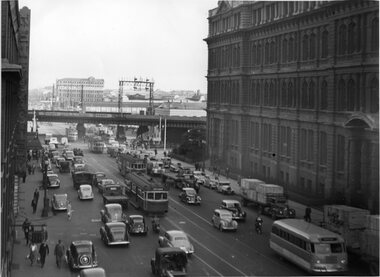
Series of 9 black and white photographs of the traffic congestion in the CBD during 1951. .1 - view looking south along Spencer St from Collins St showing the VR Head office, and the railway viaduct with a Berger Paint advertisement, Has one wide body tram with dash canopy lighting and three W2's. Also one small bus. Has "G3" in pencil on rear. .2 - similar view but with a different vehicle mix - W2 317 (Richmond Route 28), an SW6 route 27 and another W2 (route 41). Includes one large truck carrying Land Rover boxes. Typed on rear "Enlargement of No. 72 - Sheet No. 26 (Report P25/1/8) and in ink initials and "For Testing Engs 1/11/51". .3 - View looking north along Swanston St Princes Bridge with a route 6 tram and Princes Bridge Station and St Pauls Cathedral. On rear in pencil "11/2" .4 - Spencer St - trams crossing Spencer St bridge - W5 781 (Route 10) and a W2 649, route 9, South Melbourne Beach. .5 - Queensbridge under bridge - showing many cars jammed and the railway viaduct. .6 - ?? - Collins St - National Mutual and Shaw Savill Line offices - has a Safety Zone stand. .7 - Collins St looking east from Market St - with many trams in the view and many cars. .8 - Collins at Market St with a SW6 with dash canopy lighting - route 45, followed by a route 9A .9 - same location - total chaos. See also Reg 4520 for another 7 photos of the same series.trams, tramways, traffic control, congestion, spencer st, route 27, route 28, route 41, route 6, princes bridge, swanston st, w2 class, sw6 class, route 10, route 9, spencer st bridge, market st, collins st, route 45, route 9a, tram 317, tram 781, tram 649 -
 Melbourne Tram Museum
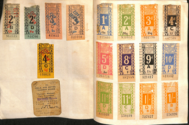
Ephemera - Exercise Book, The Reading Universal, "Tickets", 1950's to 1980's
Exercise or Mapping book - The Reding Universal Mapping book, blue front cover plain paper, holding tickets collected by Keith Stodden. Titled "Tickets". Tickets have been positioned using stamp hinges. Pages 1 to 13 - MMTB imperial, dual and decimal currency tram and bus tickers, including a Munitions workers fare concession certificate, Scholars Concession ticket, swimming, Adelaide. 14 - 15 - SEC and Brisbane tickets 16 - 17 - MTT Adelaide 18 - 24 - MMTB mixed and some railway card 25 - 26 - Sydney 26 - 28 - Hobart 29 - 30 - Mixed - MOTAT, Ferrymead, Brisbane, Hornibrook Highway Toll, 31 - 32- Melbourne Rail, mixed admission, VR Excess Fare 33 - 34 - SEC 35 - 36 - Dunedin 37 - 38 - Christchurch 39 - 41 - Wellington 42 - Auckland 43 - NZR rail 44 - MMTB 45 - 46 - MTT Adelaide, Tallahassee, St Claude 47 - 48 - Ballarat, Bendigo and TMSV 49 - MMTB 50 - TMSV, SPER 51 - Brisbane 52 - Parramatta Park (COTMA), Eurail pass 53 - Hong Kong, Melbourne rail, platform tickets, pram tickets, Begonia Festival car park, 54 - 55- Mixed - NZR, Wellington, 56 - Auckland 57 - 58 - AETM, Adelaide, 59 - 60 Adelaide, MMTB, Exhibition buildings car park, 61 - Radio receiving licence, mixed bus tricks, Ansett, TAA, 62 - cover - mixed - Ansett, TAA, Ballarat ESCo, Melbourne transport Pageant and MTA/The Mettrams, tramways, tickets, the met, mmtb, adelaide, sec, tmsv, sydney, buses -
 Melbourne Tram Museum
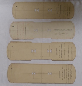
Drawing, Melbourne & Metropolitan Tramways Board (MMTB), "Car Templates", c1920 onwards
Set of 14 tram car templates contained within Reg Item 356, cut from card board to indicate the over all dimensions of the various type of tramcars. Would have been used in the drawing office for checking clearances on buildings, trackwork, junctions. Cut with holes in the centre to enable this to be done. Scale 1/2" = 1 foot. .1 - Marked "A" - for a combination car - 30' 11.25" long, 7'6" wheelbase .2 - "B" - for a combination car - 32' long, 6'6" wheel base to drawing R489 and summer or straight sill car to drawing R820. .3 - "C" - Straight Sill combination car - 33' long, 7'6" wheelbase. .4 - "D" - Combination car, length 31'11", 7'6" wheelbase .5 - "E" - Combination car, length 35', 7' wheelbase .6 - "F" - DC Bogie car, to Drawing 112, length - 44' 3.5", truck centres 22 '4" .7 - "G" - ditto length 44' 5.5", truck centres 23' 7.5" .8 - "H" - ditto length 44' 5.5", truck centres 24' 7.5" .9 - "J" - four motor bogie, to drawing 854, length 45' 6", truck centres 24'6" .10 - "K" - Combination car, length 35', 12' Radiax truck. .11 - Bogie tramcar, W class length 48', truck centres 26' 6" .12 - ditto, W2 534, length 48', truck centres 26' 0" .13 - W4 class tram, .14 - W5 730, length 46' 6', truck centres 28'trams, tramways, mmtb, plans, drawings, templates -
City of Moorabbin Historical Society (Operating the Box Cottage Museum)
Newsletter - CMHS April 2014 pdf, April 2014
The City of Moorabbin Historical Society was formed c 1960 by a group of Moorabbin area residents who were concerned that the history of the area should be preserved. A good response to a call for items related to the historical area of Moorabbin Shire brought donations of a wide variety of artefacts that are now preserved by the current members of CMHS at Box Cottage Museum. Helen Stanley, Secretary of CMHS, began producing a Newsletter for members in April 2007 to provide current information and well researched items of historical interest. Jim Dale continued to produce the Newsletter in 2013 after Helen resigned. 3 x A4 paper pages printed on one side with colour photographs, Jim Dale, President, welcomes members to the April 27th Meeting at Box Cottage. There were many visitors on the February Open Day including Jeff Marriot. In March some guests from a Wedding at the Rotunda in Joyce Park visited. Chris and Judy Hawker, relatives of early aviator Harry Hawker were presented to Her Excellency, the Governor General of Australia, Quentin Bryce during the Centenary of Military Aviation Air Show, held at Point Cook on March1st & 2nd. Jim representing CMHS attended this memorable occasion. Jim also attended Moorabbin Primary School March 3rd where he told the pupils about Harry Hawker. March 22nd Jim, Valma and Anne attended the Moorabbin Primary School Fete handing out leaflets and talking about Box Cottage Museum. City of Glen Eira is conducting a project for WW1 Centenary involving significant Street names in the area eg Monash, Chauvel, Birdwood etc. Jim has compiled a story about Thomas Calcutt 1809 - 45, a shepherd who emigrated from Oxford, England to Brighton Victoria 1842. He was part of the Henry Dendy 's assignment of settlers. Thomas obtained employment with Public Works and lived in Brighton with his family. Sadly he died during the 6km walk home from his work in St Kilda to Brighton 1845. After a 2 day search his body was found. He was the first immigrant to die in this area and subject to an Inquest.City of Moorabbin Historical Society Newsletter APRIL 2014city of moorabbin historical society, stanley helen, dale jim, melbourne, moorabbin, brighton, cheltenham, ormond, bentleigh, market gardeners, pioneers, early settlers, east bentleigh, city of kingston, marriott jeff, hawker harry, aviators, moorabbin primary school, peulich paul, point cook airforce base, bryce dame quentin, hawker judy, hawker christopher, city of glen eira, world war 1 1914-18, monash sir john, calcutt thomas, calcutt eleanor, calcutt george, calcutt rosanna, calcutt henry, dendy henry, henry dendy's special survey 1841, wilmot w b md jp, st andrew's church of england brighton victoria -
 Bendigo Historical Society Inc.
Document - Black and white laminated photo of flow of water from Lake Eppalock. 1964
John Perry Collection. Laminated copy of photo of crowd watching flow of water from the opened valve at the wall of Lake Eppalock during its commissioning. March, 1964. Lake Eppalock was created by flooding to town of Wild Duck. The dam was built by the State Rivers and Water Supply Commission of Victoria. The dam wall height is 45 metres (148 ft) and the main embankment is 1,041 metres (3,415 ft) long. At 100% capacity the dam wall was designed to hold back 304,651 megalitres (6.7014×10¹⁰ imp gal; 8.0480×10¹⁰ US gal) of water. The surface area of Lake Eppalock is 3,011 hectares (7,440 acres) and the catchment area is 2,124 square kilometres (820 sq mi). The controlled spillway is capable of discharging 8,040 cubic metres per second (284,000 cu ft/s). Lake Eppalock supplies both stock and domestic water to the Campaspe irrigation district. It also serves as a water supply to Bendigo and Heathcote and, in more recent times, Ballarat. The lake is a major attraction for those engaging in watersports, with a number of tourist parks and accommodation facilities available. Permissible activities on the lake include high-speed boating, water skiing, sailing, canoeing, fishing and swimming. The lake's water levels were low for approximately eight years between 2002 and 2010 during a prolonged drought, which restricted the amount of recreational activity until rainfall in the latter half of 2010 returned the lake to 100 percent capacity. Built between 1961 and 1964, Lake Eppalock remains the only water storage on the Campaspe River system.water, dam, reservoir, eppalock, wild duck