Showing 3762 items
matching surveyed
-
 City of Moorabbin Historical Society (Operating the Box Cottage Museum)
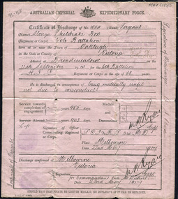
Document, Certificate of Discharge 1st AIF Alonzo Sheldrake Box 22/5/1917 2pp, 1917
Alonzo Sheldrake Box 1851- 1958 was the nephew of William and Elizabeth Box who migrated from Sussex England 1850 and established a market garden in the area of Henry Dendy's 'Special Survey 1841 Brighton, in the Parish of Moorabbin County of Bourke. Alonzo was a pavier, who laid blue stone for drains, and enlisted in 1914 to serve in Gallipoli, and France . He returned to Bentleigh 1917 and married Mary Louisa Closter 1918 . Alonzo Box was a member of the pioneering Box family who emigrated from Sussex England 1850 and established market gardens in the the Parish of Moorabbin, County of Bourke. Alonzo Box enlisted in the 1st AIF in 1914 and served in Gallipoli and France. Document, Certificate of Discharge No. 1054 Australian Imperial Expeditionary Force 1917, Alonzo Sheldrake Box Sergeant as Printed by Government Printer box george b 1808, box william, box elizabeth avis, box alonzo sheldrake, closter mary louisa, wedding dress box cottage museum, paviers, road building, world war 1 1914-1918, gallipoli, somme battles, smith j l; smith mary ann, stanley helen, smith vic, chaff cutter, horse drawn carts, early settlers, bentleigh, mckinnon, parish of moorabbin, city of moorabbin, county of bourke, moorabbin roads board, shire of moorabbin, henry dendy's special survey 1841, were j.b.; bent thomas, o'shannassy john, king richard, charman stephen, highett william, ormond francis, maynard dennis, market gardeners, vineyards, orchards -
 Warrnambool and District Historical Society Inc.
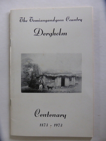
Booklet, The Temiangandeen Country Dergholm, 1973
This booklet gives information on the settlement of Dergholm at the time of the centenary of its founding, 1973. The origin of the name Dergholm is unclear but it may have Irish connections. Europeans came to the area in the 1840s and 50s but it was not until the 1870s that the town was surveyed. Dergholm is in the far west of Victoria 334 kilometres from Melbourne and nearby is Dergholm State Park established in 1982. The booklet was produced for the Centenary Back to Dergholm Committee and the local centenary celebrations. This book is of some interest as it provides information on Dergholm, a settlement in the far west of Western Victoria. This is a soft cover booklet of 52 pages by Alistair Roper. It has a cream-coloured cover with a black and white photograph of early Dergholm on the front cover (Edward Quinn’s house). The booklet has printed material - a President’s Message, an Author’s Note, Acknowledgements, Contents, information on the Dergholm area, including a list of local birds, and References. There are several black and white photographs of the area and its people. The book is stapled. Front Cover: ‘The Temiangandgeen Country, Dergholm Centenary, 1873-1973’dergholm victoria, alistair roper, history of western district of victoria -
 Robin Boyd Foundation
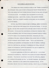
Document - Manuscript, Robin Boyd, The Crisis in Architecture
Boyd quickly surveys the first generation of modern architecture. The talk then concentrates on where modern architecture turned next: the "search for new richness on the surface and a search for new excitement in form". He focuses on the second generation of modern architects: Edward Stone (surface search) and Eero Saarinen (excitiement search). Several of their influential buildings are critiqued by Boyd. This document was the basis for a lecture titled "The Contemporary Situation in Architecture" (item D521, with edits).Typewritten, quarto, 16 pagesinternational style, mies van der rohe, frank lloyd wright, edward stone, eero saarinen, le courbuier, felix candela, matthew novicki, eduardo catalano, hugh stubbins, raymond and rado, jorn utzon, toro-ferrer -
 Surrey Hills Historical Society Collection
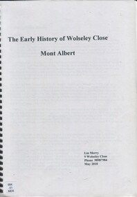
Book, The early history of Wolseley Close, Mont Albert, 2010
Includes copy of will of William Clark. Resident of the property at 9 Wolseley Close in 1910. Includes copy of the Alan Holts home occupier / tenant records - names from 1920 - 1980. Includes photo of Wolseley Close house, taken 1888/1889 plus colour photo of Wolseley Close house taken by Lin Merry, 2010. Land Title information, surveys, subdivision Includes list of occupants of the house, p.17Includes some plans of houses built in Wolseley Close, Mont Albert, Victoria. Outlines details of property at 9 Wolseley Close19p : col illcragg family, windsor crescent, surrey hills, (mr) william ainger, (mr) isaiah ainger, whitehorse road, noorn hill, house names, koonda, d j maloney, (mrs) louisa clara maggs, taramera, union road, st.abbs, york street, (mr) william henry cleverdon, wolseley street, windsor park estate, tarawera, merry family, clinton family, adams family, tel-el-kebir, farrell family, (mr) william clark, trafalgar street, (mr) (sir) matthew davies, (mr) c h james, (mr) james munro, (mrs) elizabeth clark, langdale, (mr) stanley dewar, (mr) john jose, (mrs) emily hampton, potton, (mr) alexander potton, (mr) john atkinson morris, freehold investment & banking co., mont albert, windsor park surrey hills, dalton family, (mr) henry wood, wolsley close -
 Whittlesea Historical Society Inc.
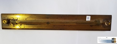
Lockwood's Brass Parallel Ruler, 19th Century
William Henry Lockwood's surveying and drafting instruments. William Lockwood was born in 1832 in Glossop, Derbyshire and came to Victoria in 1853 on the 'Marco Polo'. He settled in Whittlesea with his wife Naomi in 1856. He was contracted to the Whittlesea Road Board and was the Engineer to the Shire for a period of 40 years. Some instruments have markings 'JL' on them which is presumed to be Joseph Lockwood, William Henry Lockwood's father. There are 10 items in this collection.19th century surveying and drafting instruments used by William Henry Lockwood, Engineer to the Shire of Whittlesea, Victoria, Australia.Rectangular brass rolling parallel ruler with a length of 18 inches, the beveled edges are numbered by ones from 1 to 18, the rule is marked Kilpatrick & Co., LondonKilpatrick & Co., Londonwilliam henry lockwood, rule, brass rule, surveying instrument, drafting instrument, whittlesea road board -
 Parks Victoria - Mount Buffalo Chalet
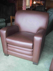
Armchairs
"Today the Chalet lounges and hallways are stocked with a number of disparate furnishings of unknown provenance - table and chair settings... many ranging in styles from Edwardian and Art Deco periods. While they may appear to be original to the rooms, the items are not evident in any of the historic photographs surveyed in the course of this report, so their historical association with the Chalet does not appear to be strong and enduring. Some... appear to be domestic furnishings rather than those of a 'resort house'.Six lounge / club chairs, covered in brown vinyl. They are solid and bulky and have square, short block-like feet of dark wood. -
 Bialik College
Document (series) - Box of strategic planning booklets and documents
strategy, elc, religion, 2000s, 1990s, 1980s, 2010s, promotionstrategy, elc, religion, 2000s, 1990s, 1980s, 2010s, promotion -
 City of Moorabbin Historical Society (Operating the Box Cottage Museum)
Photographs,x3 Colour Early Weatherboard Cottage Cheltenham c1880, 1981
Henry Dendy , a farmer from Sussex England, purchased 5,120 acres of land in the area of a 'Special Survey 1841' that extended from Brighton bayside North Road, East Boundary Rd to South Road. This area became known as Dendy's Brighton and as part of the sale 139 emigrant workers arrived in 1842 however Dendy was unable to find work and lodgings for these people. J.B.Were, financier took over the management of the 'Special Survey 1841' area and began to sell and lease allotments. 1850 the Squatter King brothers sold land south of Dendy's 'Special Survey 1841' to Josiah Holloway who sectioned it into 2 acre lots @ £10 each for market gardens - 'Two Acre Village' and Charles Whorral opened a small hotel - 'The Cheltenham Inn' on the main Road - Arthur's Seat Rd, later Point Nepean Rd, now Nepean Highway. Notable settlers who moved into the area were Keys, Charman, Bruton, Le Page, Fairlam, Meeres and 1862 saw the separation from Brighton and the formation of the Mooorabbin Roads Board District. .By 1879 1000settlers were living in 'Cheltenham' serviced by a Post Office with Bank, Mechanics Institute, State School No 84,Keys Hotel, Meeres Store, Sir Thomas Bent ensured the new Railway Line from Caulfield to Mordialloc went through his constituency of Cheltenham 1881 and this changed the development to the bayside area of Cheltenham away from the 'Two Acre Village ' side causing some dissention, However Cheltenham as whole prospered and this house in Pine St is typical of the cottages built c 1890- 1900 in the area. This weatherboard house c 1890-1900 in Pine St Cheltenham is typical of those built for early settler families. Photo taken 1981 by CMHS member 3 x Colour photographs of an early c 1900 weatherboard house in Pine St Cheltenham taken by CMHS member 1981Kodak Aug. 81 / Handwritten Pine St Cheltenhamkeys robert, holloway josiah, king brothers, smith j l; smith mary ann, stanley helen, chaff cutter, horse drawn carts, toll gates brighton, motor cars 1900, steam engines, early settlers, bentleigh, parish of moorabbin, city of moorabbin, county of bourke, moorabbin roads board, shire of moorabbin, henry dendy's special survey 1841, were j.b.; bent thomas, o'shannassy john, king richard, charman stephen, highett william, ormond francis, maynard dennis, market gardeners, vineyards, orchards -
 Warrnambool and District Historical Society Inc.
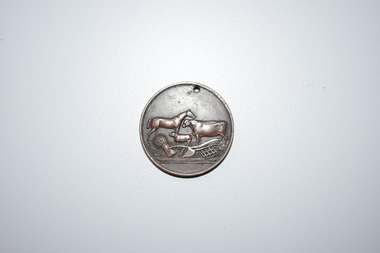
Medal, Stokes and Martin, Rutledge Brothers, 1877
This medal was made by Stokes and Martin. Thomas Stokes established a medal-making business in Melbourne in 1856 and from 1867 to 1893 he had a partner, George Frederick Martin. In 1962 the Stokes business became a public company and operates today in Melbourne. The medal was awarded at the Annual Show of the Villiers and Heytesbury Agricultural Association in 1877. One of the earliest agricultural associations in Victoria, the V.& H.A.A., the forerunner of the Warrnambool Agricultural Society, was established in 1854 and the first Warrnambool Show was held in 1855 at the first Royal Archer Hotel in Koroit Street. The Warrnambool Agricultural Show is still held annually. The medal, first prize for the best horse hay rake, was awarded in 1877 to the brothers, Thomas and William Rutledge, sons of Eliza and William Rutledge. The latter was a pioneer settler who came to the Warrnambool/Port Fairy district as the purchaser of the Special Survey, Farnham Park in 1841. His land stretched from Tower Hill to Dennington. William Rutledge Senior was a pioneer breeder of a Lincoln sheep stud, the owner of a mercantile business in Port Fairy, a member of the Legislative Council of Victoria and the pioneer developer of farming land around Tower Hill. His son Thomas (1846-1918) was a Warrnambool Shire Councillor who farmed in the Farnham Survey, living at Werronggurt . He went to the Geelong area at the end of the 19th century. His brother William (1849-1935) also farmed in the Farnham Survey, living at Farnham Park, He later lived at Airlie in Henna Street, Warrnambool and Sherwood on the Hopkins River and had land in the Otway Ranges. He later went to New Zealand.This medal is of considerable significance because of its age and its association with Thomas and William Rutledge and with the Villiers and Heytesbury Agricultural Association.This is a bronze medal with an image of agricultural implements, agricultural produce and farm animals on one side and etched printing on the other side. There is also printing around the edge of the medal. The medal has a small hole at the top for attaching the medal to a cord. Villiers & Heytesbury Agricultural Association 1st Prize awarded to Rutledge Bro. for Horse Hay Rake Annual Show Warrnambool 10 Oct. 1877 Stokes & Martin Melbourne thomas and william rutledge, farnham special survey, villiers and heytesbury agricultural association, warrnambool agricultural society, history of warrnambool -
 Bendigo Military Museum
Booklet - A survey of the North Australian Coast on AK121 Aroetta, NT Force, NT Coastal Recce Unit RAE, 6 Aust Army Topo Survey Corps, AKA121 Aroetta, 28 Mar 1945
The work of the Australian Survey Corps is to make maps for the Army. At the outbreak of war very little of the mainland had been mapped, especially the northern parts. The best maps in existence of the N.T. coast in Dec "41 were those made by Matt Flinders in 1801 -1802. The Army soon got out new maps of all important areas including much of the inland. Later it was decided to bring the complete coastline up to date. Several parties put in between them six months on the coast during the dry season of "45 but a couple more months would be needed to complete the program when the "wet" interrupted the work. A small section from Buckingham Bay - Groote Eylandt was still untouched and this diary covers that section of the N.T. Coast. A survey party of four men was chosen who were to be transported from place to place by the AK121 Aroetta - a ketch of 25 tons belonging to an army unit called N.T. Coastal Recce whose work it was to patrol the coast and as well do air - sea rescue. The survey party: Lieut Jack Worsley (the Loot) Sgt jack Love, Spr Jack Cook, Spr Pat Hede. Crew of Aroetta: Liet Ralph Warne (Skipper), Sgt Buckley (Buck) (First Mate and Ordly Rm), Sgt Jim Terjesen (Jumbo) Bosun, WO2 Tom Davis (Engineer), Cpl Kevin Monk (Artificer), L/Cpl Jack Cox (Deck Hand), Spr Jack Andrews (Signals), Spr Laurie Rament (Ass. Engineer), Spr McKenzie (Mac) (Cook). The complete history is not available after July 31 1945. The remainder of the notes are very badly water-damaged and in some places unreadable.A4 Booklet, plain paper with text and diagrams and half tone photograph of Lt Jack Worsley with plastic binderSigned by George Barton Maj. for LtCol GS. NT Forceroyal australian survey corps, rasvy, fortuna, army survey regiment, army svy regt, asr -
 Federation University Historical Collection
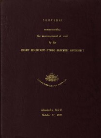
book, Truth & Sportsman Ltd, Souvenir commemorating the commencement of work by the Snowy mountains hydro-electric authority, 17/10/1949
It is assumed that a member of the Ballarat School of Mines attended the commencement of work at the Snowy Mountains hydro-electric centre.Burgundy cover with gold printing. Black print, photos and diagrams on white paper (31 pages). Bound by 3 staples. The contents include the story of the Snowy. Images include W.J. McKell, J.B. (Ben) Chifley, J. McGirr, Nelson Lemmon, Hume Weir, Jindabyne valley (now flooded), Jindabyne township (now flooded), illustration of water Power, survey team at Adaminaby, Snowy Mountains Relief Plan, Horseman crossing the Eucumbene River, Mildura, Burrinjuck Dam under construction, transmission lines, W. Hudson.snowy mountains hydro-electricty scheme, snowy mountains hydro-electric authority -
 Kew Historical Society Inc
Book, Plan of General Development, Melbourne : Report of the Metropolitan Town Planning Commission, 1929
The 1929 report of the Metropolitan Town Planning Commission covering Melbourne and its suburbs. Includes photographs and 15 folding maps (some in rear pocket) This was a planning scheme to prevent 'misuse' of land and protect property values. It highlighted traffic congestion, the distribution of recreational open space and haphazard intermingling of land uses. The plan identified a number of problems, such as the congestion at St Kilda Junction, that were not addressed until decades later. The plan also recognised the value of Melbourne's waterways as an open space network.xii, 308 p., [25] leaves of plates (24 folded) : ill., maps (some col.), ports., plans ; 34 cm. CONTENTS Part 1 Surveys and studies Part II Communications Part III The execution of improvement schemes - a programme of urgent works Part IV Zoning Part V Public Recreation Part VI Public Utilities Part VII Housing and Land Subdivision Part VIII Civic Art and Amenities Part IX Miscellaneous Part X Legislation Part XI Conclusionnon-fictionThe 1929 report of the Metropolitan Town Planning Commission covering Melbourne and its suburbs. Includes photographs and 15 folding maps (some in rear pocket) This was a planning scheme to prevent 'misuse' of land and protect property values. It highlighted traffic congestion, the distribution of recreational open space and haphazard intermingling of land uses. The plan identified a number of problems, such as the congestion at St Kilda Junction, that were not addressed until decades later. The plan also recognised the value of Melbourne's waterways as an open space network.city planning -- victoria. -- maps, city planning -- victoria -- melbourne, city planning -- victoria, civic improvement -- victoria -- melbourne, melbourne -- (vic.), cartography -
 Bayside Gallery - Bayside City Council Art & Heritage Collection
Map, Department of Crown Lands and Survey, Melbourne and Suburbs, City of Sandringham, 1917-1926
map, plan, foreshores, sndringham, hampton, beaumaris, cheltenham, department of lands and survey, cartographic material, borough of sandringham, moorabbin, black rock, street map, city of sandringham -
 University of Melbourne, Burnley Campus Archives
Plan, Rainforest Garden Development VCAH Burnley, 1990-1992
Some of these plans were held in P. Tulk's office, used by Honours Student, Linda Hipwell in 1999. (1a) Rough sketch on tracing paper. (1) Rainforest Project drawn by G. Olive, rough sketch pen and pencil on paper. (2) 1 tracing paper and 2 paper copies, Rainforest Garden Development Plant Schedule Key by type of plant. (3) Blueprint of Rainforest Garden Development, plant names beside plants, note to P. Tulk from J. Kellow. (4) Native Garden Burnley VCAH Hort Eng. II. Surveying by Gail, John, Rebecca, Sean, Tim (Students). g. olive, phil tulk, linda hipwell, vcah, students, rainforest, gardens -
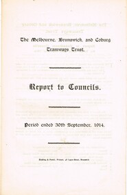 Melbourne Tram Museum
Document - Report, The Melbourne, Brunswick and Coburg Tramways Trust (MBCTT), "The Melbourne, Brunswick and Coburg Tramways Trust - Report to Constituent Councils, Nov. 1914
Report - printed onto a folded double folio sheet, titled "The Melbourne, Brunswick and Coburg Tramways Trust - Report to Constituent Councils for Period ended 30th September 1914". Outlines the setting up of the trust, the committee, survey, specifications being prepared, depot locations and alterations to services. Notes the estimated cost of construction and finance through debentures. Dated 13/11/1914. Rear page has the financial statement, including the operation of the horse tramway for six months. Audited by Strangward and Schackell. Four copies held.trams, tramways, mbctt, reports, construction, finances, horse trams -
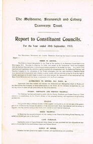 Melbourne Tram Museum
Document - Report, The Melbourne, Brunswick and Coburg Tramways Trust (MBCTT), "The Melbourne, Brunswick and Coburg Tramways Trust - Report to Constituent Councils, Oct. 1915
Report - printed onto a folded double folio sheet, titled "The Melbourne, Brunswick and Coburg Tramways Trust - Report to Constituent Councils for Period ended 30th September 1915". Outlines the committee, survey, contracts for materials, tramcars, electrical equipment, depot equipment and construction and general progress. Notes the estimated cost of construction and finance through debentures. Dated 29/10/1915. Rear page has the financial statement, including the operation of the horse tramway for six months. Audited by Strangward and Schackell. Eight copies held.trams, tramways, mbctt, reports, construction, finances, horse trams -
 Bendigo Historical Society Inc.
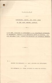
Document - MCCOLL, RANKIN AND STANISTREET COLLECTION: REPORT ON CASTLEMAINE, MALDON & OTHER AREAS
Copy of a typewritten report on Castlemaine, Maldon, and other areas of the main Bendigo District by H.W. Gepp Consultant on Development to the Commonwealth Government. W. Baragwanath Director of the Geological Survey of Victoria and F.L. Stillwell D.Sc. Council for Scientific and Industrial Research. Mentions Castlemaine, Fryertown, Maldon, South German Mine, Mt. Tarrengower Tunnel, Raywood, Sebastian, Wedderburn, Inglewood, Whipstick, Lightning Hill, Black Forest Mine, Old Tom Mine. Trentham. Dated 17th September 1931. Consists of 19 Foolscap PagesH.W. Gepp, W. Baragwanath, F.L. Stillwell.gold, mining, report, gold mining, bendigo, castlemaine, maldon -
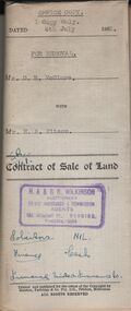 Bendigo Historical Society Inc.
Document - H.A. & S.R. WILKINSON COLLECTION: CONDITION OF SALE
Contract of sale of land dated 4th July, 1952 between Mr. D. R. McClure (seller) and Mr.. H. A. Pitson for land described in right to occupy residence area No. 9508, together with all buildings and erection thereon, also all sundries inside and outside the building. Price 60 pounds. Also attached various receipt from Department of lands and survey, copy of the right to occupy land issued in 1942, letter from the City of Bendigo dated in 1951 drawing attention to unpaid rates on the property.organization, business, h.a. & s.r wilkinson real estate -
 Bendigo Historical Society Inc.
Map - GREAT EXTENDED HUSTLER'S MINE - PLAN OF THE GREAT EXTENDED HUSTLER'S MINE
Plan of the Great Extended Hustler's Mine on the Hustler's Line of Reefs, Bendigo. Bulletin No 33, Plate No X. Lease No 7382. Plan has map of streets. Mine was located in the block bounded by Langston and Anderson Streets and was between the Hustler's Anticline at Surface and the Lightning Hill Anticline at Surface. Latham & Watson's Shaft is also mentioned. Levels are numbered and a table shows the Levels and their Depths. Geological Survey of Victoria. Signed by H A Whitelaw, Underground Suyrvey Office, Bendigo, September 1913. This item has not been scanned or photographed.mining, parish map, great extended hustler's mine, hustler's line of reefs, mining lease no 7382, geological survey of victoria, underground survey office bendigo, h a whitelaw, latham & watson's shaft -
 Mt Dandenong & District Historical Society Inc.
Photograph, Jasper Road Near Erith Lane 1920, 1920
View of Jasper Road, near Erith Lane taken in 1920. The road is tree lined with two significant gum trees in the foreground. This photograph has a detailed inscription on the back handwritten by John Lundy-Clarke in 1974.Jasper Road near Erith Lane 1920. This road has only a narrow right of way. It was put in as a road to serve “Cherry Farm”, connecting it to the Coach Road at the Elbow in 1904. It joins a wide surveyed road running from Inverness Road to the Coach Road at the Elbow and could possibly have been surveyed by Thomas Hand at the same time as Inverness Road. The name Jasper now applies to full length between Erith Lane and Coach Road. McGivern Bros widened it in 1937 and J L Clarke removed and stored much of the rock quarried in the widening. This was later sold to Dick Moorby who sold it to the builders of St Michaels Church in Falls Road. Comment by John Lundy-Clarke 10.5.1974 jasper road, erith lane, john lundy-clarke -
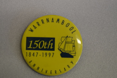 Warrnambool and District Historical Society Inc.
Badge, Warrnambool 150th 1847-1997
This badge was produced in 1997 as a souvenir of the 150th anniversary of the founding of Warrnambool. Warrnambool was a planned town, established in 1847 as a port to service the squatters who had taken up large tracts of land in the Warrnambool area in the 1840s.The town was surveyed by the Government surveyor William Pickering at the request of Superintendent La Trobe and the first town lots of the new town were sold in Melbourne in 1847, with some settlers arriving at the new settlement soon after.This badge is one of the many souvenirs of the 1997 celebrations in Warrnambool Circular concave metal badge with blue drawing of a sailing ship and text. There is a clip pin on the reverse.WARRNAMBOOL ANNIVERSARY 150th 1847 -1997 -
 Wodonga & District Historical Society Inc
Map - Boorgunyah - "The Town that never was"
At the height of the river trade, there was a town surveyed and laid out, and streets were named. This town was to house the workers at the river port of Red Bank when the paddle steamers plied the Murray River as far as Albury, carrying produce such as wool and wheat to the various towns along the river in the 1800s. As the river trade died away, this town never went ahead – one might say, “The town that never was.” A lone gum tree stands on the site today.This item is significant because it documents plans which were made for the early development of Wodonga.A black an white map depicting the proposed location of the township. The map is based on a sketch and is not to scale,early wodonga, boorgunyah - "the town that never was", wodonga heritage -
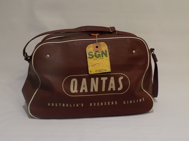 Geoffrey Kaye Museum of Anaesthetic History
Qantas bag
Dr James (Jim) Villiers went to Vietnam as an anaesthetist with the Australian Surgical Team (civilian) during 1963. He used this bag for carry-on luggage. Despite assurances about the quality of resources available on arrival, he carried an essential part of the breathing circuit for an EMO vaporiser in his carry-on. The actual vaporiser was packed in his check-in luggage. In 1963 the Vietnamese government sought training in Australia in anaesthetics for several medical technicians. Australia was not able to meet the request as anaesthesia training in Australia is restricted to qualified doctors. Instead, the Dean of the Faculty of Anaesthetists at RACS suggested sending a team of anaesthetists to Vietnam to conduct training for technicians there. However, they requested a preliminary survey be undertaken in order to determine the abilities of the prospective trainees and establish contacts with medical authorities in Vietnam. James (Jim) Villiers was one of the people who undertook the survey and made a report. Training of Vietnamese medical technicians was undertaken using the Epstein MacIntosh Oxford Anaesthetic Apparatus (EMO). This equipment was robust, portable and relatively cheap, there are few moving parts for servicing, it requires only ether and air for operation.Brick-red vinyl bag with white Qantas branding including the flying kangaroo printed on both sides. The bag has a zipper opening and contains an anaesthetic apparatus mounted on a piece of wooden particle board. There are two black hoses, a white hose, a black plastic connector, a metal t-bar connect, a green resuscitation bag and black face mask.james villiers, malignant hyperthermia, vietnam, qantas, australian surgical team, long xuyen, bien hoa, anaesthesia training -
 Bendigo Historical Society Inc.
Document - HARRIS COLLECTION: HAMS SQUATTING MAP OF VICTORIA, PORT PHILLIP DISTRICT, NSW
Folding map enclosed in burgundy cover. Map backed by cloth and bound. Rare, early map of Victoria and neighbouring Port Phillip District of New South Wales. Written on bottom RH corner of map: Ham's Squatting Map of Victoria ( Port Phillip District, New South Wales ) carefully corrected to this date from the Colonial Government Surveys, Crown Lands, Commissioners & Explorers Maps, Private Surveys & c. Respectfully inscribed (with permission ) to His Excellency Sir Chas A. Fitz-Roy Knt, Governor of New South Wales &c &c by his Obedient Servant, The Compiler, 1851. Compiled, engraved and published by Thomas Ham, Melbourne. Proposed and original boundary ( in legend) have been coloured in in blue and pink ink ( later addition ?) Number on map show 'reference to proprietor's Printed on back of map ' J.G. AD 1852, with two cross hatched decorations and two hearts entwined. On other back panel in pencil enclosed in a drawn frame ' G.S.H., 1889, Axedale' (George Harris, Axedale, belongs in Harris Collection) Stamped in purple ink 'Royal Historical Society of Victoria, Bendigo Branch. Written 1959, 53.map, victoria, squatting map -
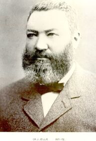 Port Fairy Historical Society Museum and Archives
Photograph, Cr J Jellie Shire of Belfast President 1871-72
Councillor James Jellie came to Melbourne from Ireland in 1841 and moved to Belfast in 1843. he then relocated to Warrnambool in 1849 where he worked as a farmer. He later entered into business as an auctioneer, loan and estate agent and valuation and several large properties passed through his hands. He was one of the partners in the auctioneering firm that sold Atkinson’s Crown Special Survey. His municipal activities extended to the Shire of Warrnambool as well as the Borough of Belfast.Black and white portrait government, belfast, president, portrait, shire, municipal, local-government, auctioneer, james jellie -
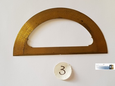 Whittlesea Historical Society Inc.
Instrument - Lockwood's Brass Protractor 180 degrees, 19th Century
Brass protractor used by William Henry Lockwood. William Lockwood was born in 1832 in Glossop, Derbyshire and came to Victoria in 1853 on the 'Marco Polo'. He settled in Whittlesea with his wife Naomi in 1856. He was contracted to the Whittlesea Road Board and was the Engineer to the Shire for a period of 40 years. Some instruments have markings 'JL' on them which is presumed to be Joseph Lockwood, William Henry Lockwood's father. There are 10 items in the Lockwood Surveying and Drafting Instruments Collection.19th century surveying and drafting instruments used by William Henry Lockwood, Engineer to the Shire of Whittlesea, Victoria, Australia.Lockwood's brass semi circular protractor divided into 180 degrees and marked from end to end by 10 degree increments from 10 to 170brass protractor, william henry lockwood, surveying instrument, drafting instrument, whittlesea roads board, engineering, 1856 -
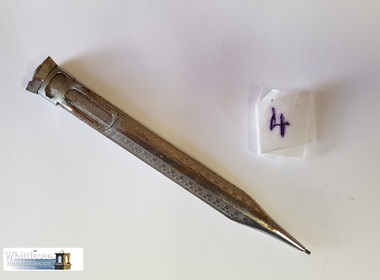 Whittlesea Historical Society Inc.
Instrument - pencil, Lockwood's retractable pencil, 19th Century
Retractable pencil used by William Henry Lockwood. William Lockwood was born in 1832 in Glossop, Derbyshire and came to Victoria in 1853 on the 'Marco Polo'. He settled in Whittlesea with his wife Naomi in 1856. He was contracted to the Whittlesea Road Board and was the Engineer to the Shire for a period of 40 years. Some instruments have markings 'JL' on them which is presumed to be Joseph Lockwood, William Henry Lockwood's father. There are 10 items in the Lockwood Surveying and Drafting Instruments Collection.19th century surveying and drafting instruments used by William Henry Lockwood, Engineer of Whittlesea, Victoria, Australia.Lockwood's silver coloured chrome plated steel retractable pencil with extendable core leadpencil, lead pencil, william henry lockwood, drafting instrument, surveying instrument, whittlesea road board, whittlesea engineer, 1856 -
Greensborough Historical Society
Newsletter, Greenhills and North Greensborough Progress Association, Community News: official journal of the Greenhills and Nth. Greensborough Progress Association and the Apollo Parkways Progress Association.13th December, 1976. Edition No. 11/76, 13/12/1976
This edition includes a report on the The Apollo Parkways Progress Association's November 1976 meeting, Goodbye to old Greensborough?, Lament for the loss of my loved one - Greensborough, Is bigger best?, Church of Christ, This and That, A breeding success story, Cameo of Eric and Prisca Rosario, Land of the brave & the free, Grief, Nursing Mothers Association, Parent Australia, From the Council Chamber, School news, Scout news, Plenty Valley Squash Club, Bird survey of Yandell Reserve. Newsletter, 24 p., illus., map.greenhills and north greensborough progress association, greenhills, apollo parkways progress association, apollo parkways -
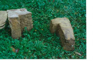 Buninyong & District Historical Society
Photograph - Original Photograph, C J Brooks, Sandstone blocks awaiting incorporation into reconstruction of wall, 405 Learmonth St. Buninyong, July 1995
Stone of which wall is constructed is believed to have been used in the construction of Jamieson's Buninyong Inn, built for Margaret Jamieson starting about 1853. She owned the earlier Buninyong Inn which impinged on they surveyed Learmonth St. and was demolished. Margaret died in 1854 before the building was completed by her son, who built the third Buninyong Inn on the corner of Learmonth and Warrenheip. The two story hotel was tenented for a while, then bought by Dr. Sparling who demolished it.Colour photo, Sandstone blocks awaiting incorporation into reconstruction of wall, 405 Learmonth St. Buninyongbuninyong, jamieson, sparling, buninyong inn, wall, sandstone -
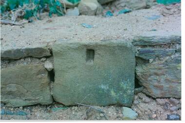 Buninyong & District Historical Society
Photograph - Original Photograph, C J Brooks, Individual Sandstone block showing hole to support wooden strut, in reconstruction of wall, at 405 Learmonth St. Buninyong, July 1995
Stone of which wall is constructed is believed to have been used in the construction of Jamieson's Buninyong Inn, built for Margaret Jamieson starting about 1853. She owned the earlier Buninyong Inn which impinged on they surveyed Learmonth St. and was demolished. Margaret died in 1854 before the building was completed by her son, who built the third Buninyong Inn on the corner of Learmonth and Warrenheip. The two story hotel was tenented for a while, then bought by Dr. Sparling who demolished it.Colour photo, bottom section of wall, showing individual Sandstone block with hole to support wooden strut, in reconstruction of wall, at 405 Learmonth St. Buninyongbuninyong, jamieson, sparling, buninyong inn, wall, sandstone