Showing 518 items
matching burke road
-
 Melbourne Tram Museum
Document - Personal Papers, Jack McLean, Keith Kings, "Tramway / Railway level crossings", 1954
... Glenferrie Road Hawthorn Glenferrie Road Malvern Burke Road... Showgrounds Glenferrie Road Hawthorn Glenferrie Road Malvern Burke ...Set pf personal papers concerning tramway / railway level crossings in Melbourne. Consist of .1 - letter to Ross dated 19/3/1984, carbon copy from Jack McLean, printed on computer paper perforated computer paper torn into strips - has hand written notes. Three separate sheets. Covers Market St Melbourne (Queensbridge) South Melbourne (City Road) St George Road - North Fitzroy Queens Parade Clifton Hill Epsom Road Showgrounds Glenferrie Road Hawthorn Glenferrie Road Malvern Burke Road Camberwell, Glenferrie Rd Kooyong, Burke Road Gardiner Glenhuntly Road Glenhuntly Glenhuntly Road Elsternwick, Whitehorse Road (Deepdene), Riversdale Road, Riversdale Lygon St North Carlton Nicholson St Footscray Nicholson St North Fitzroy, .2 - six pages - retype of above document on A4 computer printing paper - covers the same material. .3 - Hand drawing of the Melbourne rail system with crossing dates including bridges noted on it for cable and electric tramways. Has initials KK 12/54 in bottom right hand corner. drawn on lined double width foolscap paper.trams, tramways, level crossings, railway squares, tramway square, cable trams -
 Surrey Hills Historical Society Collection
Book, A History of Camberwell, 1964
... Junction and Burke Road, pre 1950's era. Electric transport 1916... photographs of Camberwell Junction and Burke Road, pre 1950's era ...Includes description including photographs of Camberwell Junction and Burke Road, pre 1950's era. Electric transport 1916-1925, tools and waterways. Published [Brisbane] : Jacaranda Press in association with the Camberwell City Council, 1964 From estate of Ken Hall; Cheryl Poustie was Ken's daughter. Records in detail history and development of the Melbourne suburb of Camberwell. A city covering thirteen square miles. Begins with first European settlement in 1835 by John Gardiner - ending at 1960.Records in detail history and development of the Melbourne suburb of Camberwell. A city covering thirteen square miles. Begins with first European settlement in 1835 by John Gardiner - ending at 1960.Title Page: Kenneth T.Hall / 89-4418camberwell - history, (mr) john gardiner, outer circle railway, camberwell (vic) - history, broughton hall -
 Melbourne Tram Museum
Document - Research Notes, H. S. McComb, development and timing of the "PMTT" - part 4, 1950's
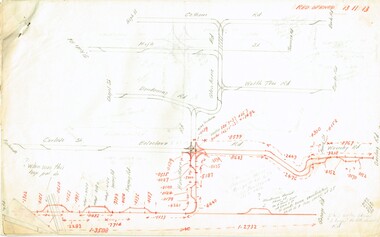
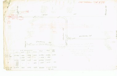
... , primarily of Burke Road, sketches of track layout, opening dates..., primarily of Burke Road, sketches of track layout, opening dates ...Set of papers, handwritten concerning the development and timing of the "PMTT", Prahran and Malvern - about 40 sheets. Prepared by H. S. McComb - gives layout of the PMTT system, primarily of Burke Road, sketches of track layout, opening dates, sketches of various junctions, bridges, track miles, junctions, reconciliation of track lengths from various sources includes Glenferrie and Cotham Road, Balaclava Road, Hawthorn Road, Glenhuntly Road, Waverley Road and St Kilda Esplanade, Candy Corner. Items 2041 to 2052 within box 72.3 in a brown folder marked "PMTT" in red pencil.trams, tramways, pmtt, malvern, routes, track, surveys, glenferrie rd, cotham rd, balaclava rd, hawthorn rd, waverley rd, st kilda, candy corner -
 Melbourne Tram Museum
Document - Research Notes, H. S. McComb, development and timing of the "PMTT" - part 5, 1950's
... , primarily of Burke Road, sketches of track layout, opening dates... - gives layout of the PMTT system, primarily of Burke Road ...Set of papers, handwritten concerning the development and timing of the "PMTT", Prahran and Malvern - about 20 sheets. Prepared by H. S. McComb - gives layout of the PMTT system, primarily of Burke Road, sketches of track layout, opening dates, sketches of various junctions, bridges, track miles, junctions, reconciliation of track lengths from various sources includes High St Malvern, extension to Punt Road, Dandenong Road, Wattle Tree Road, including its duplication Items 2041 to 2052 within box 72.3 in a brown folder marked "PMTT" in red pencil.trams, tramways, pmtt, malvern, routes, track, surveys, wattle tree rd, punt rd, dandenong rd, high st, duplications -
 Melbourne Tram Museum
Document - Research Notes, H. S. McComb, "Extracts from the Minutes of the Prahran and Malvern Tramways Trust which was constituted under Act of Parliament No. 21030 in 1907", 1940's
... purchase, regrading of High St, extension to Burke Road, relocation... purchase, regrading of High St, extension to Burke Road, relocation ...Original and carbon copy of "Extracts from the Minutes of the Prahran and Malvern Tramways Trust which was constituted under Act of Parliament No. 21030 in 1907", 10 foolscap sheets. Includes depot purchase, regrading of High St, extension to Burke Road, relocation of water mains, surveys, starting of construction, tenders for track and buildings, opening, extension, F. A. McCarty & Co., Dandenong Road lines, railway bridges, extension of High St to St Kilda Road, MMBW, finances. Items 2041 to 2052 within box 72.3 in a brown folder marked "PMTT" in red pencil.trams, tramways, pmtt, malvern, routes, track, surveys, malvern rd, tenders, construction, opening, dandenong rd, mmbw, finances -
 Melbourne Tram Museum
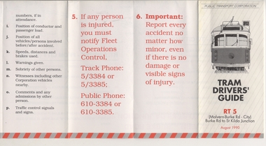
Pamphlet, Public Transport Corporation (PTC), "Tram Drivers' Guide RT 5", Aug. 1990
... for the Route 5 Malvern Bourke Road from Burke Road to St Kilda Road... Malvern Bourke Road from Burke Road to St Kilda Road, showing ...Pamphlet for tramcars, sheet of paper folded into pocket size, 12 folds, printed on gloss paper with black and red colours titled "Tram Drivers' Guide RT 5", providing g a map for the Route 5 Malvern Bourke Road from Burke Road to St Kilda Road, showing notes for both directions, compulsory stops, facilities and features. On the reverse side, has notes regarding classes of tram, information about accidents and telephone numbers. Dated August 1990. 2nd copy added 11-12-17 from Donation of Ron Scholten.trams, tramways, ptc, malvern burke rd, accidents, tram drivers, map -
 Glen Eira Historical Society
Letter - Caulfield Fire Station, No 26, Tree Reserve, Dandenong Road
... Road and Burke Road, dated 23/08/1894 prepared by E Yeatman... Tooronga Road and Burke Road, dated 23/08/1894 prepared by E ...A two page photocopy of a handwritten list of property owners and property widths in Dandenong Road between Tooronga Road and Burke Road, dated 23/08/1894 prepared by E Yeatman for F G Wood. The file also includes a one page photocopy of a handwritten letter dated 04/09/1894 from F G Wood to the Fire Brigade Board, Melbourne consenting to the erection of a fire station on Tree Reserve. The file also includes a two page photocopy of handwritten, undated, unattributed illegible notes.wood fred geo, fire brigade board melbourne, dandenong road, derby road, heywood john g, federal building society, tree reserve, caulfield east, catani charles, delves mrs h, giles john, newing w j, cadden robert, forster e, masters j, jenkins j, fire stations, yeatman e -
 Kew Historical Society Inc
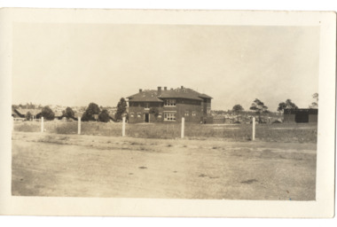
Postcard - Kew East State School No.3161, 35 Kitchener Street, c.1927
... to the extension of the High Street tram to Harp Road then Burke Road... tram to Harp Road then Burke Road then improved tram ...What is now Kew East Primary School was opened on its current site in Kitchener Street in 1923. The Kew East and Mont Albert Heritage Gap Study (August 2020) established that: 'Kew East Primary School No. 3136 is historically significant for the evidence it provides of an early phase in the development of Kew East which gathered momentum from the 1920s, as housing developed rapidly and the population increased in response to the extension of the High Street tram to Harp Road then Burke Road then improved tram connections between the area and the city.'A rare and early photograph of the school taken four years after its construction. Small, sepia coloured photographic positive of East Kew State School. The two storey red brick building was opened in 1923. This view, three years after its construction shows preliminary fencing and undeveloped playing grounds.schools -- kew east (vic.), government schools -- kew -- kew east, strathalbyn street -
 Melbourne Legacy
Photograph, Holmbush, 194X
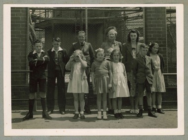
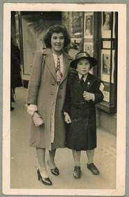
... . Including trips to the zoo and picnics. Holmbush at 1267 Burke road... to the zoo and picnics. Holmbush at 1267 Burke road, was one ...Photo of two residents of Holmbush, who appear to be greeting or farewelling a guest in a fur coat. The names are not known but was with other photos of the girls and the guest at Holmbush, see items 02338 and 02339. From a photo album which contains photos of Holmbush and some of the excursions and events that happened there, appears to have been put together in the 1940s. Including trips to the zoo and picnics. Holmbush at 1267 Burke road, was one of the properties that Legacy used for Junior Legatees. It was purchased 1942. In 1957 Holmbush was renamed Blamey House until it was sold in 1977.A compilation of photos of some junior legatees in the Legacy residences.Black and white photo of two girls from Holmbush with a guest pasted to the pages of an album.residences, holmbush -
 Melbourne Legacy
Photograph, Holmbush excursion to the zoo, 194X
... to the zoo and picnics. Holmbush at 1267 Burke road, was one.... Holmbush at 1267 Burke road, was one of the properties that Legacy ...Photo of an excursion to the Melbourne Zoo possibly in the 1940s. The matron is believed to be Dorothy Farmer, names of the children are not known but most appear in other photos from the photo album. From a photo album which contains photos of Holmbush and some of the excursions and events that happened there, appears to have been put together in the 1940s. Including trips to the zoo and picnics. Holmbush at 1267 Burke road, was one of the properties that Legacy used for Junior Legatees. It was purchased 1942. In 1957 Holmbush was renamed Blamey House until it was sold in 1977.A compilation of photos of the matron and junior legatees in the Legacy residences.Black and white photo of Matron and children at the Melbourne Zoo pasted to the page of an album.residences, holmbush, matron -
 Melbourne Legacy
Photograph, Holmbush girls, 194X
... . Holmbush at 1267 Burke road, was one of the properties that Legacy.... Holmbush at 1267 Burke road, was one of the properties that Legacy ...Photo of two girls that lived at Holmbush. They appear to be in front of some shops. The youngest is wearing a school uniform and hat. These girls appear in other photos in the album. From a photo album which contains photos of Holmbush and some of the excursions and events that happened there, appears to have been put together in the 1940s. Including trips to the zoo and picnics. Holmbush at 1267 Burke road, was one of the properties that Legacy used for Junior Legatees. It was purchased 1942. In 1957 Holmbush was renamed Blamey House until it was sold in 1977.A compilation of photos of junior legatees from the Legacy residences.Black and white photo of two girls from Holmbush pasted to the page of an album.residences, holmbush, junior legatees -
 Melbourne Legacy
Photograph, Holmbush excursion to the beach, 194X
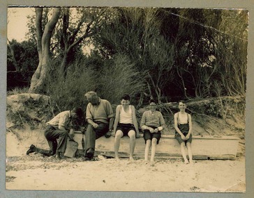
... . Including trips to the zoo and picnics. Holmbush at 1267 Burke road... and picnics. Holmbush at 1267 Burke road, was one of the properties ...Photo of an excursion of Holmbush children to the beach possibly in the 1940s. It is probably a Legatee that is with the boys. The names are not known but most of the boys appear in other photos from the photo album. From a photo album which contains photos of Holmbush and some of the excursions and events that happened there, appears to have been put together in the 1940s. Including trips to the zoo and picnics. Holmbush at 1267 Burke road, was one of the properties that Legacy used for Junior Legatees. It was purchased 1942. In 1957 Holmbush was renamed Blamey House until it was sold in 1977.A compilation of photos of the junior legatees in the Legacy residences.Black and white photo of four boys and a legatee at the beach pasted to the page of an album.residences, holmbush, beach -
 Melbourne Tram Museum
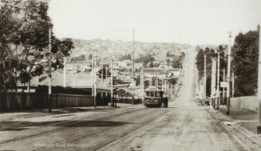
Photograph - Black and white - Whitehorse Road, Balwyn c1920's
... , at the intersection with Burke Road. Photo has a caption "Whitehorse Road..., at the intersection with Burke Road. Photo has a caption "Whitehorse Road ...Shows B class tram number 90, east bound in Whitehorse Road, at the intersection with Burke Road. Photo has a caption "Whitehorse Road Balwyn c1920s". Tram has the PMTT style destination board. There are a number of people standing on the right hand side of the tram. Note the shelter on the left hand side. This shelter remains in same position (2022). Tram No. 90, was built by James Moore during 1917-1918 and was sold to the Electric Supply Co of Victoria in 1931 and became Bendigo No 7.Yields information about the location, the landscape and the trams in use at the time.Black and white photograph of an outbound tram in Whitehorse Road c1920s, looking east.tramways, balwyn, whitehorse road, tram 90, shelters, pmtt, james moore, b class -
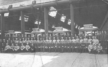 Melbourne Tram Museum
Photograph - Malvern Depot - traffic employees, c1919
... , Esplanade, Mont Albert and Burke Road. The three cars on the right..., Esplanade, Mont Albert and Burke Road. The three cars on the right ...Photograph of some 94 traffic staff in front of the Malvern Depot, possibly near the time of the MMTB absorption of the PMTT. The employees are wearing two different styles of uniforms (63 dark and 31 light) all with caps. Shows the roller doors at the top of the depot and the overhead trolley mechanism that allowed the doors to close and bypass the trolley wire. There are four trams behind the men - each showing a different destination - Windsor, Esplanade, Mont Albert and Burke Road. The three cars on the right appear to be C class cars. Yields information about PMTT depot employees c1919Black and white print mounted onto a light brown card Under the print is a letter machine blue / white Dymo label under - "KEW DEPOT"tramways, personnel, uniforms, destination boxes, pmtt, mmtb, trams, c class, malvern depot -
 Kew Historical Society Inc
Plan - Subdivision Plan, Goldthorns Hill Estate, 1925
... of the Burke Road tram to High Street. Discerning buyers were advised... extension of the Burke Road tram to High Street. Discerning buyers ...Pru Sanderson, in her groundbreaking ‘City of Kew Urban Conservation Study : Volume 2 - Development History’ (1988), summarised the periods of urban development and subdivisions of land in Kew. The periods that she identified included 1845-1880, 1880-1893, 1893-1921, 1921-1933, 1933-1943, and Post-War Development. These periods were selected as they represented periods of rapid growth or decline in urban development. An obvious starting point for Sanderson’s groupings involved population growth and the associated economic cycles. These cycles also highlighted urban expansion onto land that was predominantly rural, although in other cases it represented the decline and breakup of large estates. A number of the plans in the Kew Historical Society’s collection can also be found in other collections, such as those of the State Library of Victoria and the Boroondara Library Service. A number are however unique to the collection.The Kew Historical Society collection includes almost 100 subdivision plans pertaining to suburbs of the City of Melbourne. Most of these are of Kew, Kew East or Studley Park, although a smaller number are plans of Camberwell, Deepdene, Balwyn and Hawthorn. It is believed that the majority of the plans were gifted to the Society by persons connected with the real estate firm - J. R. Mathers and McMillan, 136 Cotham Road, Kew. The Plans in the collection are rarely in pristine form, being working plans on which the agent would write notes and record lots sold and the prices of these. The subdivision plans are historically significant examples of the growth of urban Melbourne from the beginning of the 20th Century up until the 1980s. A number of the plans are double-sided and often include a photograph on the reverse. The Goldthorns Hill Estate subdivision was first put up for auction in 1925. The subdivision took its name from the mansion ‘Goldthorns’, shown on the plan between Normanby Road and Lady Loch’s Drive. Contemporary advertisements describe forty-three home sites being fro sale, yet only forty-one appear on this plan. Buyers were lured by the prospect of the proposed extension of the Burke Road tram to High Street. Discerning buyers were advised that only one house could be built per allotment, and that houses needed to be constructed of brick, stone or concrete and have a slate or tiled roof.goldthorns avenue -- kew east (vic.), lady loch drive -- kew east (vic.), argyle road -- kew east (vic.), lady brassey drive -- kew east (vic.), campbell street -- kew east (vic.), goldthorns -- kew (vic.), subdivisions -- kew east (viv.), goldthorns hill estate -
 Melbourne Tram Museum
Document - Research Notes, H. S. McComb, development and timing of the "PMTT" - part 2, 1950's
... , primarily of Burke Road, sketches of track layout, opening dates..., primarily of Burke Road, sketches of track layout, opening dates ...Set of papers, handwritten concerning the development and timing of the "PMTT", Prahran and Malvern - about 40 sheets. Prepared by H. S. McComb - gives layout of the PMTT system, primarily of Burke Road, sketches of track layout, opening dates, sketches of various junctions, bridges, track miles, junctions, reconciliation of track lengths from various sources includes Whitehorse Road, Victoria St cable tram terminus, Kew Depot, Candy Corner, St Kilda terminus, Malvern Depot, High St, Items 2041 to 2052 within box 72.3 in a brown folder marked "PMTT" in red pencil.trams, tramways, pmtt, malvern, routes, track, kew depot, burke rd, surveys, victoria st, whitehorse rd, malvern depot, st kilda, candy corner -
 Melbourne Legacy
Document, Blamey House
... that the location on Burke Road is a very good one and the buildings were... and the buildings in detail noting that the location on Burke Road is a very ...Documentation dated January 1974 obtained by Legatee Trebilcock as a member of the Steering Committee (Residences) which had been formed to advise on the future of the Melbourne Legacy residences. See also Cat.No. 01676. The document describes the location and the buildings in detail noting that the location on Burke Road is a very good one and the buildings were quite sound. See also Cat. No. 01677. Main building had been built about 50 years before and the annex 40 years before document. There was an asphalt tennis court used for basketball and a small library. Part of the history of Melbourne Legacy's involvement with residential care for children.Photocopies x 3 pages, with black type. residences, review, committee, blamey house -
 Melbourne Legacy
Photograph, Holmbush, 194X
... and picnics. Holmbush at 1267 Burke road, was one of the properties.... Holmbush at 1267 Burke road, was one of the properties that Legacy ...Photo of the matron and 5 members of Holmbush in the driveway of the home. The matron is likely to be Dorothy Farmer, who was matron of Holmbush for many years.The other names are not known. There are two other photos of the occasion, see 02339 and 02340. From a photo album which contains photos of Holmbush and some of the excursions and events that happened there, appears to have been put together in the 1940s. Including trips to the zoo and picnics. Holmbush at 1267 Burke road, was one of the properties that Legacy used for Junior Legatees. It was purchased 1942. In 1957 Holmbush was renamed Blamey House until it was sold in 1977.A compilation of photos of some junior legatees in the Legacy residences.Black and white photo of matron and 5 young adults in the driveway at Holmbush pasted to the pages of an album.residences, holmbush, matron -
 Melbourne Legacy
Photograph, Holmbush excursion to the zoo, 194X
... . Holmbush at 1267 Burke road, was one of the properties that Legacy... Burke road, was one of the properties that Legacy used ...Photo of an excursion to the Melbourne Zoo possibly in the 1940s. The matron and children are riding elephants. The matron is believed to be Dorothy Farmer, names of the children are not known but most appear in other photos from the photo album. From a photo album which contains photos of Holmbush and some of the excursions and events that happened there, appears to have been put together in the 1940s. Including trips to the zoo and picnics. Holmbush at 1267 Burke road, was one of the properties that Legacy used for Junior Legatees. It was purchased 1942. In 1957 Holmbush was renamed Blamey House until it was sold in 1977.A compilation of photos of the matron and junior legatees in the Legacy residences.Black and white photo of Matron and children on elephants at the Melbourne Zoo pasted to the page of an album.residences, holmbush, matron -
 Melbourne Legacy
Photograph, Holmbush excursion, 194X
... . HHolmbush at 1267 Burke road, was one of the properties that Legacy.... HHolmbush at 1267 Burke road, was one of the properties that Legacy ...Photo of an excursion to what appears to be Port Philip bay possibly in the 1940s. The children range in age. The matron is believed to be Dorothy Farmer, names of the children are not known but most appear in other photos from the photo album. From a photo album which contains photos of Holmbush and some of the excursions and events that happened there, appears to have been put together in the 1940s. Including trips to the zoo and picnics. HHolmbush at 1267 Burke road, was one of the properties that Legacy used for Junior Legatees. It was purchased 1942. In 1957 Holmbush was renamed Blamey House until it was sold in 1977.A compilation of photos of the matron and junior legatees in the Legacy residences.Black and white photo of Matron and 4 residents of Holmbush by water pasted to the page of an album.residences, holmbush, matron -
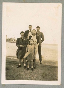
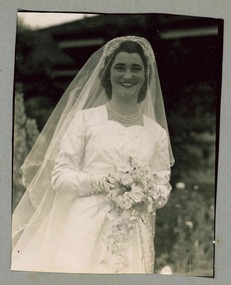 Melbourne Legacy
Photograph, Holmbush residents, 194X
... at St Patrick's Cathedral. Holmbush at 1267 Burke road, was one.... Holmbush at 1267 Burke road, was one of the properties that Legacy ...Photo of a girl that lived at Holmbush dressed for her wedding. The bridesmaid may also be a resident of Holmbush. The man in one photo is likely to be another resident. If this bride was the same as in the newspaper article that was in the album, it gives the name of the bride as Lexie Curtin and the bridesmaid as Nora Southern. The groom was Dr John Ferguson who was also a member of Legacy for some years. The wedding was held at St Patrick's Cathedral. Holmbush at 1267 Burke road, was one of the properties that Legacy used for Junior Legatees. It was purchased 1942. In 1957 Holmbush was renamed Blamey House until it was sold in 1977.A compilation of photos of some junior legatees in the Legacy residences.Black and white photo x 4 of bride and bridesmaid at Holmbush and a newspaper clipping pasted to the pages of an album.residences, holmbush, junior legatees -
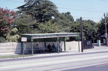 Melbourne Tram Museum
Slide - Set of 17 - Tramway Shelters, Robert Green, c1990
... and Burke Road, Deepdene 4 - Tramway Shelter (PMTT) - Cnr. Cotham... - ditto 3 - Tramway Shelter (PMTT) - Cnr. Cotham Road and Burke ...Set of 17 colour slides of tramway shelters, poles, and substations by Robert Green c1990. Shelters by the PMTT, HTT and MMTB 1 Tramway Shelter (PMTT) - Cnr Balaclava and Orrong Road, Caulfield 2 - ditto 3 - Tramway Shelter (PMTT) - Cnr. Cotham Road and Burke Road, Deepdene 4 - Tramway Shelter (PMTT) - Cnr. Cotham Road and Burke Road, Deepdene with telephone box alongside. 5 - Cnr. Malvern Rd and Orrong Road, Toorak 6 - Cnr. Malvern Rd and Orrong Road, Toorak 7 - Cnr. Dandenong Road and Hawthorn Road, Caufield 8 - ditto 9 - PMTT Substation - Rusden Street, Elsternwick 10 - PMTT poles cnr. Dandenong Road and Wattletree Road 11 - Tram shelter (HTT) Riversdale Road and Highfield Road - Camberwell - Highfield Park 12 - Tram shelter (HTT) Riversdale Road and Wattlevalley Road, Camberwell 13 - ditto 14 - Tram shelter (HTT) Camberwell Road, cnr Bowen St. Camberwell. 15 - Tram Shelter (HTT) Camberwell Depot, Riversdale Road, Hawthorn 16 - Merri Creek Bridge, St. Georges Road, North Fitzroy 17 - Merri Creek Bridge, St. Georges Road, North Fitzroy - foundation stone Yields information about Melbourne's tramway stop shelters and other infrastructure.Set of 17 Kodak colour slides in plastic mounts.tramways, shelters, caufield, deepdene, toorak, orrong road, cotham road, balaclava road, pmtt, htt, mmtb, riversdale road, camberwell depot, merri creek bridge, foundation stone, dandenong road, poles, rusden st, substations, hawthorn road, st.georges road -
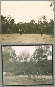 Melbourne Legacy
Photograph, Holmbush picnic, 194X
... . Holmbush at 1267 Burke road, was one of the properties that Legacy.... Holmbush at 1267 Burke road, was one of the properties that Legacy ...Photos of what appears to be a excursion in the bush with Holmbush children and legatees, possibly in the 1940s. The names of the children and legatees are not known. They appear to be playing basketball on a rudimentary court. Also some of the cars that transported them. Picnic tables can be seen with the cars. From a photo album which contains photos of Holmbush and some of the excursions and events that happened there, appears to have been put together in the 1940s. Including trips to the zoo and picnics. Holmbush at 1267 Burke road, was one of the properties that Legacy used for Junior Legatees. It was purchased 1942. In 1957 Holmbush was renamed Blamey House until it was sold in 1977.A compilation of photos of the matron and junior legatees from the Legacy residences on an outing with legatees.Black and white photo x 2 of children and Legatees on a an excursion and playing basketball pasted to the page of an album.residences, holmbush, picnic, junior legatee outing -
 Kew Historical Society Inc
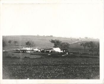
Photograph, Kilby Farm, Kew East
... bullock track [later Kilby Road] to the Yarra, and east to Burke... track [later Kilby Road] to the Yarra, and east to Burke Road ...Kilby Lodge (c.1845-c.1922). William Oswin purchased Crown Land Lots 52 & 53 in 1845. These lots ran north from an old bullock track [later Kilby Road] to the Yarra, and east to Burke Road. Oswin purchased a neighbouring Lot in 1851, separated by the bullock track from the rest of the farm. Oswin built ‘Kilby Lodge’ and, with his brother, farmed dairy cattle on the site. Oswin’s descendants owned the farm into the 1890s. New subdivisions of Kilby and neighbouring farms in the 1920s changed the rural nature of north Kew. Housing and large recreation reserves replaced dairy farms and market gardens. This work forms part of the collection assembled by the historian Dorothy Rogers, that was donated to the Kew Historical Society by her son John Rogers in 2015. The manuscripts, photographs, maps, and documents were sourced by her from both family and local collections or produced as references for her print publications. Many were directly used by Rogers in writing ‘Lovely Old Homes of Kew’ (1961) and 'A History of Kew' (1973), or the numerous articles on local history that she produced for suburban newspapers. Most of the photographs in the collection include detailed annotations in her hand. The Rogers Collection provides a comprehensive insight into the working habits of a historian in the 1960s and 1970s. Together it forms the largest privately-donated collection within the archives of the Kew Historical Society.A panoramic photograph of Kilby (or Oswin's) Farm in East Kew."Kilby Farm when Oswins owned it. Commenced 1845."kilby farm, kilby lodge, william oswin, dorothy rogers, kew east -
 Kew Historical Society Inc
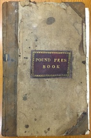
Administrative record (item), Borough of Kew, Pound Fees Book, 1874-1896
... of land bounded by the Kilby Road, Burke Road and High Street... by the Kilby Road, Burke Road and High Street. While the Governor ...While the first successful land sales in Boroondara occurred in Hawthorn in 1843, and Kew in 1845, these areas were to be without local pounds until April 1858, when the Governor of Victoria, in accordance with Act 18 Victoria No 30, was pleased to direct the establishment of a Pound at Glass’s Creek on that part of land bounded by the Kilby Road, Burke Road and High Street. While the Governor was required to proclaim the establishment of a pound, the appointment of a poundkeeper was the responsibility of the Justices of the Peace in the local Court of Petty Sessions. The Pound took its name from the most distinctive natural feature of the area, Glass’s Creek, named after the early pastoralist Thomas Glass.The register is of historic significance as an indicator of suburban life in the second half of the 19th Century. It shows how farming and city life on the urban fringe were intimately connected. It is also significant to the early history of Hawthorn and Kew, who both claimed the Pound following their separation from the Boroondara Roads Board in 1861."Kew Pound Book"glass creek pound (kew), animal pound, dog pound, kew pound, j. smith, john oakes, samuel b. cash, edward s. delaney, emma oswin, samuel cash -
 Kew Historical Society Inc
Plan - Subdivision Plan, H C Crouch, Old Golf Links Estate, 1930s
... bridge’ over the Yarra at Burke Road is also marked on the inset... as ‘Recreation Ground’. The ‘new bridge’ over the Yarra at Burke Road ...The land in North Kew between the Outer Circle Railway and the River Yarra was released in sections. This release included 80 lots. Most of this area was released during the Depression years in the early 1930s.Subdivision plans are historically important documents used as evidence of the growth of suburbs in Australia. They frequently provide information about when the land was sold on which a built structure was subsequently constructed as well as evidence relating to surveyors and real estate and financial agents. The numerous subdivision plans in the Kew Historical Society's collection represent working documents, ranging from the initial sketches made in planning a subdivision to printed plans on which auctioneers or agents listed the prices for which individual lots were sold. In a number of cases, the reverse of a subdivision plan in the collection includes a photograph of a house that was also for sale by the agent. These photographs provide significant heritage information relating house design and decoration, fencing and household gardens.One part of a massive subdivision of the Old Golf Links Estate in North Kew of 80 allotments bordering Sutherland Avenue, Ramsay Avenue, Belford Road, Beresford Street and Coleman Avenue. Inset on the plan at the top left, the route of the Outer Circle Railway is clearly marked. The Kew Golf Links is identified in its current location. The land on which Greenacres Golf Club was to be constructed is at this time marked as ‘Recreation Ground’. The ‘new bridge’ over the Yarra at Burke Road is also marked on the inset map. The Plan identifies the surveyor (sic) H.C. Crouch BCE MVIS, 443 Little Collins St., Melbourne. The date of the subdivision auction sale in identified as Saturday September 25th at three o'clock.Annotations: "E" top left. "Golf Links" top right. Lots 73-76 ticked and listed as "6" poundssubdivisions -- kew (vic.), old golf links estate -
 Kew Historical Society Inc
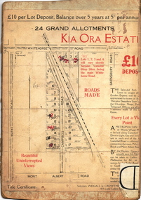
Plan - Subdivision Plan, Kia Ora Estate, 1930s
... , Barnsbury Road, Campbell Road, Mont Albert Road and Burke Road..., Mont Albert Road and Burke Road. The lots were advertised ...Twenty-five grand allotments were offered for sale in the subdivision known as the Kia Ora Estate in Balwyn in the early 1930s. The streets identified in the subdivision include Whitehorse Road, Barnsbury Road, Campbell Road, Mont Albert Road and Burke Road. The lots were advertised for £10 deposit, with the balance to be paid over 5 years at 5 per cent per annum. The lots bordering Whitehorse Road were nominated as potential valuable shop sites, while the Mont Albert Road lots were advertised as having ‘wonderful views’. The Outer Circle Railway Line is shown traversing the subdivision. The route of the Railway in this area is now a walking/bike track bordered by strips of parkland.subdivision plans - balwyn, kia ora estate -
 Melbourne Tram Museum
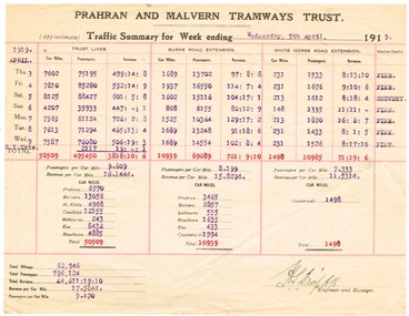
Document - Report, Prahran & Malvern Tramway Trust (PMTT), "Prahran and Malvern Tramways Trust - Traffic Summary for week ending 9th April 1919", Apr. 1919
... , Burke Road extension and the White Horse Extension along... of the reporting week. Gives details for the Trust lines, Burke Road ...Quarto sheet - printed and typed form - report - "Prahran and Malvern Tramways Trust - Traffic Summary for week ending 9th April 1919". Gives the car miles, passengers and revenue for each day of the reporting week. Gives details for the Trust lines, Burke Road extension and the White Horse Extension along with a summary of revenue, revenue per car mile and passengers per car mile. Also notes the weather conditions. Item .2 to .5 added 9-8-2018 from donation of Bob Wilson. .2 - Week ending 12/3/1919 .3 - ditto 19/3/1919 .4 - ditto 26/3/1919 .5 - ditto 2/4/1919trams, tramways, pmtt, tramcars, reports, passengers -
 Kew Historical Society Inc
Photograph - Kew Main Drain, 1984
... just west of Burke Road at Kew High School before discharging... of Burke Road at Kew High School before discharging into the Yarra ...'Kew, Kew East, Balwyn & Balwyn North are located approximately 7km north east of Melbourne. Four main stormwater drains service the area flowing from south to north. Three of the drains: Deepdene Drain; Balwyn Drain & Glass Creek converge in Kew East just west of Burke Road at Kew High School before discharging into the Yarra River. The fourth drain, Kew Main Drain connects directly with the Yarra River to the West of Glass Creek.' The Kew Main Drain is a barrel drain that was created in the 1930s, and follows the route of the former Connor's Creek from the vicinity of Genazzano FCJ College to the Yarra River in East KewImportant and verifiable evidence of the construction methods used by the Melbourne & Metropolitan Board of Works in building the Kew Main Drain, before its reconstruction in c.1985.Original print colour positive photograph of the Kew Main Drain, provided on 14/12.84 to the Chief Engineer of the City of Kew, Ian Poulter, by the Supervising Engineer (Works), Southern and Eastern Drainage, Melbourne & Metropolitan Board of Works. The record includes an image of the reverse as well as the donation document from the MMBW."A84/1855-9 / 750mm council drain looking D/S [down stream] and across Parkhill Road. To be replaced with 1200 mm R.C.P. [reinforced concrete pipe] as part of MMBW Kew Main Drain reconstruction works"kew main drain, stormwater drains -- kew (vic.), connor's creek -- kew (vic.) -
 Kew Historical Society Inc
Photograph - Kew Main Drain, 1984
... just west of Burke Road at Kew High School before discharging... of Burke Road at Kew High School before discharging into the Yarra ...'Kew, Kew East, Balwyn & Balwyn North are located approximately 7km north east of Melbourne. Four main stormwater drains service the area flowing from south to north. Three of the drains: Deepdene Drain; Balwyn Drain & Glass Creek converge in Kew East just west of Burke Road at Kew High School before discharging into the Yarra River. The fourth drain, Kew Main Drain connects directly with the Yarra River to the West of Glass Creek.' The Kew Main Drain is a barrel drain that was created in the 1930s, and follows the route of the former Connor's Creek from the vicinity of Genazzano FCJ College to the Yarra River in East KewImportant and verifiable evidence of the construction methods used by the Melbourne & Metropolitan Board of Works in building the Kew Main Drain, before its reconstruction in c.1985.Original print colour positive photograph of the Kew Main Drain, provided on 14/12.84 to the Chief Engineer of the City of Kew, Ian Poulter, by the Supervising Engineer (Works), Southern and Eastern Drainage, Melbourne & Metropolitan Board of Works. The record includes an image of the reverse as well as the donation document from the MMBW."A84/1855-10 / 750mm council drain looking U/S [up stream] from Parkhill Road, Kew."kew main drain, stormwater drains -- kew (vic.), connor's creek -- kew (vic.)