Showing 288 items
matching location plan
-
 Wodonga & District Historical Society Inc
Album - Hume Reservoir Australia Album - Plans and Progress Photos - River Murray Water Scheme, Department of Public Works, N.S.W, 1927
This set of photos is from a leather bound album bearing the inscription "HUME RESERVOIR AUSTRALIA" plus 'The Rt. Hon. L. C. M. S. Amery, P. C., M .P.' all inscribed in gold. It was presented to The Rt. Hon. L. C. M. S. Amery, P. C., M. P, Secretary of State for Dominion Affairs on the occasion of his visit to the Hume Reservoir on 2nd November 1927. This album is of local and national significance as it documents the planning and development of the Hume Reservoir up to 1927. It was the largest water reservoir in the British Empire. The album records the pioneering engineering work that went into its construction.1. Locality Plan and Plan of Dam. The dam is about ten miles by road upstream from Albury and about three-quarters of a mile below the confluence of the Mitta Mitta River and the Murray River. Its main features consist of a concrete portion across the bed of the river with earth embankment at both ends. The foundations throughout are on hard granite, found at an average depth of about 40 feet below the surface, the centre line being located to take advantage of the most favourable rock levels.Heading on page "WORKS UNDER RIVER MURRAY WATERS AGREEMENT/HUME RESERVOIR" Beneath top diagram "FIG. 1. ELEVATION" Beneath second diagram "FIG. 2. PLAN" On map "LOCALITY PLAN"hume reservoir australia, river murray waters scheme, hume weir diagrams, hume weir location -
 Wodonga & District Historical Society Inc
Map - Boorgunyah - "The Town that never was"
At the height of the river trade, there was a town surveyed and laid out, and streets were named. This town was to house the workers at the river port of Red Bank when the paddle steamers plied the Murray River as far as Albury, carrying produce such as wool and wheat to the various towns along the river in the 1800s. As the river trade died away, this town never went ahead – one might say, “The town that never was.” A lone gum tree stands on the site today.This item is significant because it documents plans which were made for the early development of Wodonga.A black an white map depicting the proposed location of the township. The map is based on a sketch and is not to scale,early wodonga, boorgunyah - "the town that never was", wodonga heritage -
 City of Kingston
Map - Parish of Moorabbin
Warning: This object includes historical language referring to First Nations Peoples which is no longer appropriate but has been recorded for historical purposes. Produced in 1853, this map shows the land holdings of European families. While the majority of holdings are small there are also large land holdings as can be seen with Henry Dendy's Special Survey. Of particular note is the "Reserve for Aborigines" which was established in approximately 1841 and consisted of over 830 acres. This area is the current location of Mordialloc township and Attenborough Park, in Mordialloc, is the last remnant of the reserve. An Alfred Sikes, possibly the surveyor/cartographer who drew this parish plan, purchased land in Berwick in 1854.A handrawn map on fabric, with blue markings representing the coastline to Port Phillip Bay, red markings representing a proposed train line to Mordialloc, major roads and street, as well as a "Reserve for Aborigines", which constituted approximately 830 acres. In the bottom right hand corner, the map has been signed and dated.Handwritten in ink: Alfred Sikes / 38 Collins St East / June. 1853moorabbin, mordialloc, dendy, port phillip bay, aboriginal reserve, attenborough park -
 Melbourne Legacy
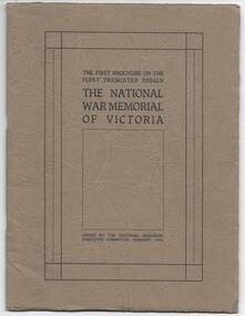
Booklet, The First Brochure on the First Premiated Design. The National War Memorial of Victoria, 1928
A booklet produced by Hudson and Wardrop, Architects, who had won the contest for the design of the Shrine. This booklet shows their models of the Shrine in photos and diagrams of the site. It goes into detail of the plans for Rock of Remembrance, the eye of light, the porticos, the tympanums, the inner Shine, and materials it will use, etc. It says: 'The theme is Remembrance, and the doing is indicative of Remembrance. It is Australian in feeling, in that is stands for the highest of Australian ideals - ideals we fought for - Patriotism, Sacrifice, Justice and Freedom.' Messrs Hudson and Wardrop were also returned servicemen. This booklet could have been used to inform the public of the plans whilst fundraising for the building project. In 1928 the Governor asked for the public to contribute approx £100,000 towards the project, while the State Government had already guaranteed £80,000. (Actual budget ended up being £250,000). Item was in an envelope with other photos and programmes from different items relating to the Shrine of Remembrance - including discussions on its location and design. Labelled 'Shrine of Remembrance S1 - S14' it was part of an old archive numbering system, that showed there has been efforts in the past to collect, order and save items of Legacy's history. (01181 - 01190, 01206 - 01211, 01649, 01650).A record of the planning for the Shrine of Remembrance with details from the architects who had won the design contest. There was an effort to record historical events for the "Archive Committee" which collected this and other documents relating to the Shrine together in a file (see items 01181 - 01190, 01206 - 01211, 01649, 01650).Booklet x 20 pages, describing plans for the Shrine, buff paper in a dark grey brown cover with black and white photos and black print.memorial, shrine of remembrance -
 Melbourne Legacy
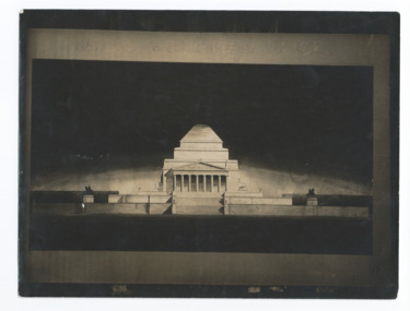
Photograph, National War Memorial of Victoria, 1928
A photo of a model produced by Hudson and Wardrop, Architects, who had won the contest for the design of the Shrine. This photo shows their model of the Shrine as seen from the North. It is with their Brochure on the First Premiated Design (see 01208) which goes into detail of the plans for Rock of Remembrance, the eye of light, the porticos, the tympanums, the inner Shine, and materials it will use, etc. It says: 'The theme is Remembrance, and the doing is indicative of Remembrance. It is Australian in feeling, in that is stands fo rate highest of Australian ideals - ideals we fought for - Patriotism, Sacrifice, Justice and Freedom.' Messrs Hudson and Wardrop were also returned servicemen. This photo could have been used to inform the public of the plans whilst fundraising for the building project. In 1928 the Governor asked for the public to contribute approx £100,000 towards the project, while the State Government had already guaranteed £80,000. Item was in an envelope with other photos and programmes from different items relating to the Shrine of Remembrance - including discussions on its location and design. Labelled 'Shrine of Remembrance S1 - S14' it was part of an old archive numbering system, that showed there has been efforts in the past to collect, order and save items of Legacy's history. (01181 - 01190, 01206 - 01211).A record of the planning for the Shrine of Remembrance with details from the architects who had won the design contest. There was an effort to record historical events for the "Archive Committee" which collected this and other documents relating to the Shrine together in a file (see items 01181 - 01190, 01206 - 01211).Black and white photo of the architects model of the Shrine of Remembrance.memorial, shrine of remembrance -
 Melbourne Legacy
Document, Stanhope
Documentation dated January 1974 obtained by Legatee Trebilcock as a member of the Steering Committee (Residences) which had been formed to advise on the future of the Melbourne Legacy residences. See also Cat.No. 01676. The document describes the location and the buildings in detail and advises that Stanhope appears to be satisfactory for its purpose and easily converted to a co-ed facility. The photocopied plan is also dated January 1974, but the definition is poor. Items were compiled in a folder with documents pertaining to the residences. Stanhope was at 1245 Burke Rd Kew and was owned by the Red Cross.Part of the history of Melbourne Legacy's involvement with residential care for children.Photocopies x 5 pages, black on white. Photocopied architectural plan, black on white paper.residences, review, committee, stanhope -
 Melbourne Legacy
Document - Document, report, Staff Organisation Legacy House Present and Future. 20/7/1990, 1990
Legacy staff numbers when this document was written in 1990 were 28 full time staff and 5 part time. In 1982 there were 31 full time and 1 part time. The report discusses increasing the hours of a clerk/typist, not re-appointing a person to replace The Senior Pensions Advocate and a new appointment with computer skills. Wages increased by 53.3%. The wage increase was in line with award rates. Salaries rose by 51.8% from June1983 to April 1990. The report also discusses staff leave, work environment, staff morale and adequacy of office equipment. The future (3-5 years) was discussed in regard to pensions, welfare, housing accommodation for widows and handicapped dependants and fund raising. Location to be checked TBA There were a number of suggestions as to how to maintain current activities and not employ extra staff. The question was asked " Should we now in 1990 be encouraging our Executive Officer to make greater input on our decision making and be given greater resposibility"?Melbourne Legacy has been continually discussing and updating its programe and procedures to maintain its relevance.White foolscap paper with black type, 5 pages about staff organisation.staff, planning -
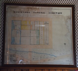 Buninyong Visitor Information Centre
Plan - Cemetery Plan, Buninyong General Cemetery
Plan of the complete layout of the Buninyong General Cemetery drawn by Robert [surname unclear] on 6 April 1871.Framed and glazed original large hand drawn plan of the Buninyong General Cemetery, showing the locations of denominational sections and plots. Buninyong General Cemeterycemeteries, historic sites, buninyong -
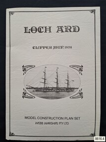 Flagstaff Hill Maritime Museum and Village
Document - Ship Model Plans, Webb Warships Pty Ltd, Loch Ard Clipper Ship, 1874; Model Construction Plan Set, 1978
The plans are presented in a keepsake folder. They show marks of sections copied and assembled together. Overall, the plans are similar to those drawn by Mr P Webb to the order of the Loch Ard Shipwreck Centenary through Mr P Williams, the organizer of the Centenary competition. “The details were based on all available information which resulted in considerable historical research…and received favourable comment from model makers because of their attention to detail…In excess of 650 sets of plans were sold before entries closed…Many plans were probably purchased by collectors and interested persons for historical reference. An illustrated historical story sheet…was prepared and enclosed with the plans…” (‘Loch Ard Shipwreck Centenary 1878-1978 Report’, November 1978). An example of the attention to historical detail on the plans is the inclusion of the following useful information about the original vessel … Tonnage….1,693 G.R.T., 1,624 N.R.T. Dimensions, Builders….Charles Connell & Co., Ltd., Scotstoun, 1873. Owners….General Shipping Co., Glasgow, (Aitken Lilburn & Co., Ltd.), and the ship’s fate. The plans, in conjunction with the scale Ship Model of the LOCH ARD also on display, are of interpretive significance to Flagstaff Hill Maritime Village. The plans provide historical and technological context to artefacts from the shipwreck, increasing understanding and appreciation of those objects. Flagstaff Hill’s collection of artefacts from LOCH ARD is significant for being one of the largest collections of artefacts from this shipwreck in Victoria. It is significant for its association with the shipwreck, which is on the Victorian Heritage Register (VHR S417). The collection is significant because of the relationship between the objects, as together they have a high potential to interpret the story of the LOCH ARD. The LOCH ARD collection is archaeologically significant as the remains of a large international passenger and cargo ship. The LOCH ARD collection is historically significant for representing aspects of Victoria’s shipping history and its potential to interpret sub-theme 1.5 of Victoria’s Framework of Historical Themes (living with natural processes). The collection is also historically significant for its association with the LOCH ARD, which was one of the worst and best known shipwrecks in Victoria’s history.Model ship plans for building the LOCH ARD. The three sets of plans are presented in a textured cream card folder with the supplier’s details and an oval cameo drawing of the LOCH ARD. The plans are detailed and drawn to scale. They and printed on good quality paper with details, scale and legends. Sheet 1: Sails and Rigging Sheet 2: Lines, Decks and Details Sheet 3: Masts and Spars Details include deck fittings, the wheel, lights and the shipping company’s house flag. The ship model plans are copyrighted in 1977 and 1978 to Webb Warships Pty Ltd. The folder has details of four locations; Australia, USA, UK and New Zealand. Sheet has a handwritten inscription.On Folder: "LOCH ARD CLIPPER SHIP, 1874, MODEL CONSTRUCTION PLAN SET, WEBB WARRIORS PTY LTD." "CONTENTS COPYRIGHT (C) 1978, WEBB WARSHIPS PTY LTD" "WEBB WARSHIPS PTY LTD, PO BOX 50, WILLIAMSTOWN, VICTORIA 3016, AUSTRALIA" Handwritten inscription on sheet 3: "834" "THE FLOATING DRYDOCK, PO BOX 16066, PHILADELPHIA, PENNA. 14114, USA" "SAMBROOK MARINE (PLANS), 84 BROAD ST. TEDDINGTON, MIDDLESEX, UK" "BYMODELS, PO BOX 3037, FORBURY, DUNEDIN, NEW ZEALAND" flagstaff hill, warrnambool, shipwrecked coast, flagstaff hill maritime museum, maritime museum, shipwreck coast, flagstaff hill maritime village, great ocean road, loch line, loch ard, captain gibbs, eva carmichael, tom pearce, glenample station, mutton bird island, loch ard gorge, ship model plans, loch ard model plans, sailing ship, loch ard centenary, webb warriors pty ltd, 1977, 1978, centenary competition -
 Port Melbourne Historical & Preservation Society
Plan - Handcoloured location of Libbis family members' homes on copy of a section of 1894 MMBW map, 1894
... of various Libbis family members Plan Handcoloured location of Libbis ...Obtained from MMBW by Peter LIBBIS when researching Libbis family historyPhotocopy of a section of 1894 MMBW plan 118 which have been handcoloured to indicate locations such as homes of various Libbis family membershandcoloured to indicate locations such as homes of various Libbis family membersbuilt environment, families, peter libbis -
Port Melbourne Historical & Preservation Society
Plan - Handcoloured location of Libbis family members' homes on copy of a section of 1894 MMBW map, 1894
... of various Libbis family members Plan Handcoloured location of Libbis ...Obtained from MMBW by Peter LIBBIS when researching Libbis family historyPhotocopy of a section of 1894 MMBW plan 118 which has been handcoloured to indicate locations such as homes of various Libbis family membershandcoloured to indicate locations such as homes of various Libbis family membersbuilt environment, families, peter libbis -
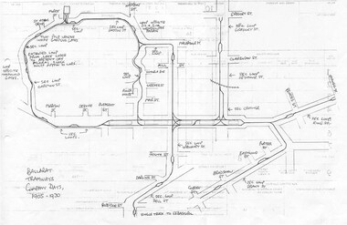 Ballarat Tramway Museum
Document - Photocopy, Dave Macartney, Drawing of ESCo Ballarat Tramways, c1990
... to Sebastopol. Plan shows the location of the loops, loop type, street... system, excluding the single track to Sebastopol. Plan shows ...Photocopy of a drawing prepared by Dave Macartney in the mid 1980's of the track layout of the Electric Supply Co. of Victoria's Ballarat Tramway system, excluding the single track to Sebastopol. Plan shows the location of the loops, loop type, street names, position of replacement loops installed by the SEC during the reconstruction, depot layout, powerhouse siding and railway in Lydiard St. North. Prepared from inspecting the Plans of Ballarat services drawings in the Ballarat Water Board's Offices. Drawn on the back of old import forms of a light weight paper and has shown through the printing underneath. Titled "Ballarat Tramways Company Days 1905 - 1930" Number of small differences to the map drawn for Keith Kings, "The Ballarat Tramways" book, page 22.trams, tramways, ballarat, esco, track layout, map -
Bendigo Historical Society Inc.
Document - VICTORIA HILL - PLAN OF THE VICTORIA REEF GOLD MINES COMPANY
Plan of the Victoria Reef Gold Mines Company, Bendigo showing the Eastern Victoria Reef, Victoria Reef and the Western Victoria Reef. Streets, gullies and leases drawn in. Some amounts of money and names have been written on the page. Signed by H. B. Nicholas. Locations of Ballerstedt's, Luffsman's, Wittscheibe's, Midway Co and Rae's engines are shown. Ironbark, Derwent, Providence and Long Gullies are shown. Also Mount Korong Road. Leases mentioned are: Jackson, Burrows, Wybarndt, Ballerstedt, Luffsman, Roberts, Ashley, Grant, Troy, Tezeau, Woodward, Croath, Taylor, Cranshaw, Gou?d & Co, Midway, Wittscheibe, Specimen Hill Co,Endeavour, Albert Co, Ballerstedt & Son, Hy? Co, and Wheadon.document, gold, victoria hill, victoria hill, plan of the victoria reef gold mines company, h b nicholas, spiers, jackson, burrows, wybarndt, ballerstedt, luffsman, roberts, ashley, grant, troy, tezeau, woodward, croath, taylor, cranshaw, gou?d & co, midway, wittscheibe, specimen hill co, endeavour, albert co, ballerstedt & son, hy? co, and wheadon -
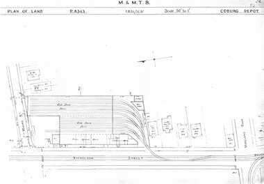 Melbourne Tram Museum
Drawing, Melbourne & Metropolitan Tramways Board (MMTB), "Coburg Depot", c1937
Set of two photocopied plans or drawings on A3 sheet of Coburg Depot - c1937 .1 - P8343 - Plan showing depot block and building plan with adjacent private houses and properties .2 - P8344 - Detail plan of depot - with notes about possible plans and changes - 4/1967. shows substation location.trams, tramways, drawings, depots, property, coburg depot, substation -
 Melbourne Tram Museum
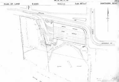
Drawing, Melbourne & Metropolitan Tramways Board (MMTB), "Hawthorn Depot", c1937
Set of three photocopied plans or drawings on A3 sheet of "Hawthorn Depot" - c 1938 .1 - P8392 - Plan of land showing Depot, surrounding land and streets - 2 copies held .2 - P8393 - Plan showing detail layout of depot, buildings and fences - 2 copies held .3 - P8394 - Plan showing detail of offices and basement Drawings 2 and 3 show substation location.trams, tramways, drawings, depots, property, hawthorn depot, substation -
 Melbourne Tram Museum
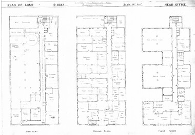
Drawing, Melbourne & Metropolitan Tramways Board (MMTB), "Head Office", c1938
Set of three photocopied plans or drawings on A3 sheet of "Head Office" - c1937 .1 - P8643 - Plan showing Basement, Ground Floor and First Floor - shows MCC substation location in basement. .2 - P8644 - Plan showing Second, Third and fourth floors .3 - P8394 - Plan showing firth floor and roof, with lift rooms.trams, tramways, drawings, depots, property, head office, mmtb, substation -
 Melbourne Tram Museum
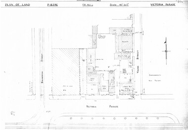
Drawing, Melbourne & Metropolitan Tramways Board (MMTB), "Victoria Parade", "Rae St Fitzroy", c1938
Set of three photocopied plans or drawings on A3 sheet of the "Victoria Parade" and "Rae St Fitzroy", c/1938. .1 - sheet 1 - P8396 - showing layout of buildings, adjacent properties at the intersection of Victoria Parade and Young Street - includes the offices, sub-station and shedding and location of No. 95 Victoria Parade - sheet 2 - P8397 - shows details of No. 95 Victoria Parade and the Two story Traffic offices at the corner of Young and Victoria Parade. .2 - P8405 - Plan of property - block and buildings of No. 449 Rae St Fitzroy. A web search shows that an advertisement was placed for the Carowindra Private Hospital at this location - advertised in the Fitzroy City Press - 14/2/1920 - Trove - access 12-9-2016. This became part of the Central Bus Garage property - see Reg Item 1745.trams, tramways, drawings, depots, property, victoria parade, young st, substation, hospital -
 Melbourne Tram Museum
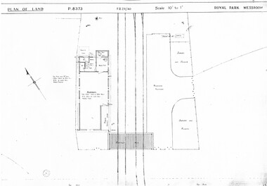
Drawing, Melbourne & Metropolitan Tramways Board (MMTB), "Royal Park Messroom", "Swanston St shunt", "Signal Box, St Kilda Junction", c1938
Set of three photocopied plans or drawings on A3 sheet of the "Royal Park Messroom" .1 - P8373 - Royal Park Messroom - corner Flemington Road and Abbotsford St - Route 55, shows passenger platform and fencing. .2 - P8447 - Swanston St shunt - signal box - shows detail of the building at the junction of Swanston St and Victoria Streets. .3 - P8484 - "Signal Box, St Kilda Junction" - show location of the signal box, adjacent streets and details of the building itself.trams, tramways, drawings, depots, property, route 55, royal park, signal box, victoria st, swanston st, st kilda junction, wellington st -
 Melbourne Tram Museum
Drawing, Melbourne & Metropolitan Tramways Board (MMTB), "Substations", c1938
Set of 7 photocopied plans or drawings on A3 sheet of various MMTB properties for the following locations. .1 - P8194 - Embankment North Coburg - 18-5-1938 .2 - P8055 - Park Northcote - 28-10-1937 - showing a park at the corner of St Georges Road and Merri Parade Northcote .3 - P8403 - Property at 27 Scotchmer St, North Fitzroy - c1938 .4 - P8177 - Fitzroy Stables, Victoria St and Fitzroy St - 19-11-1938 .5 - P8092 - Cottage in Royal Park - 29-6-1939 .6 - P?? - Land at the corner of Gertrude and Smith St Fitzroy - undated .7 - P8302 - Plan of buildings at the corner of Gertrude and Smith St Fitzroy, c1938.trams, tramways, drawings, depots, property, north coburg, fitzroy, stables, royal park, gertrude st, smith st -
 Melbourne Tram Museum
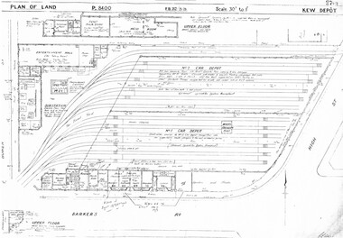
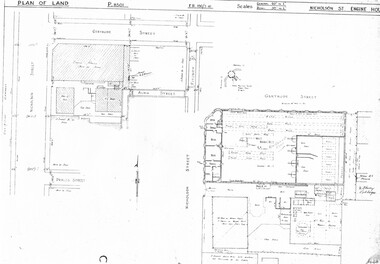
Drawing, Melbourne & Metropolitan Tramways Board (MMTB), "Kew Depot", c1938
Photocopied plans or drawings on A3 sheet of "Kew Depot 22/9/1938 P8400 - Plan of land and buildings - with some 1967 notes shows substation location.trams, tramways, drawings, depots, property, kew, substation -
 Melbourne Tram Museum
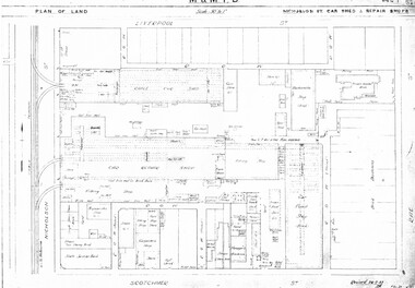
Drawing, Melbourne & Metropolitan Tramways Board (MMTB), "Central Bus Garage", "Nicholson St car shed and repair shops", c1938
Set of four photocopied plans or drawings on A3 sheets of the "Central Bus Garage" and the "Nicholson St car shed and repair shops" .1 - Plan showing block and details of the cable car facilities, repair shops and car paint shop - drawing dated 28-7-1933. .2 - Plan of the block showing the various properties and buildings - shows bus garage location. .3 - South part of drawing No. 1019 - showing the various properties, title details, purchased costs and dates - includes the hospital at Rae St - see Reg Item 1738.2 for details. Dated 8/1940. .4 - North part of the above drawing.trams, tramways, drawings, depots, property, cable trams, nicholson st, central bus garage, buses -
 Melbourne Tram Museum
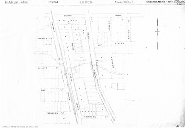
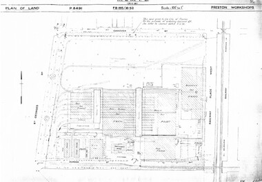
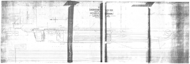
Drawing, Melbourne & Metropolitan Tramways Board (MMTB), "Preston Workshops", c1938
... -1939 .3 - P8493 - Plan of Offices and location of sub-station... and Hall - 3-2-1939 .3 - P8493 - Plan of Offices and location ...Set of nine photocopied plans or drawings on A3 sheets of the "Preston Workshops" - c1939 .1 - P8491 - Plan of land showing layout and associated drawings including Reservoir railway line - 19-4-1939. .2 - P8492 - Plan of Timber stacks and Hall - 3-2-1939 .3 - P8493 - Plan of Offices and location of sub-station - 13-12-1938 .4 - P8494 - Plan of Store including Oil store - c1939. .5 - P8495 - Plan of Paint Shop and relationship to timber stack - 1-3-1939 .6 - P8496 - Plan of Car building and Repairs shop - 6-12-1938 .7 - P8497 - Plan of machine shop - 10-12-1938 .8 - P8500 - Plan of Blacksmiths shop - 1-12-1938 .9 - P8590 - Plan of Substation - 1-12-1938trams, tramways, drawings, depots, property, preston workshops, workshops, substation -
 Melbourne Tram Museum
Drawing, Melbourne & Metropolitan Tramways Board (MMTB), "Nicholson St Engine House", c1938
... , Fitzroy. P8501 - plan showing the location, adjacent properties... Houses Nicholson St Gertrude St Photocopied plans or drawings ...Photocopied plans or drawings on A3 sheets of the "Nicholson St Engine House" at corner of Gertrude and Nicholson St, Fitzroy. P8501 - plan showing the location, adjacent properties and details of the Engine House - dated 3-2-1938.trams, tramways, drawings, depots, property, cable trams, engine houses, nicholson st, gertrude st -
 Melbourne Tram Museum
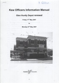
Manual, Yarra Trams, "Glen Huntly Depot Renewal", "Kew Depot - Pit Deepening Roads 1 to 4", "Camberwell Depot Yard Tracks Renewal", 2007 to 2011
Set of three Reports or Operations Plan or Manual for work at Kew and Glen Huntly Depots. .1 - 12 A4 pages - stapled - "Kew Officers Information Manual - Glen Huntly Depot renewal" - Friday 11 May 2007 to Monday 21st May 2007". Has a photo of the depot on the front sheet. Covers service changes, arrangements for changes to services running from Kew Depot, car parking, tram requirements. Has a table of contents. .2 - 7 A4 pages - stapled - "Operations Plan - "Kew Depot - Pit Deepening Roads 1 to 4" = Monday 23 June 2008 to Friday 18 July 2008" - has a table of contents, covers maintenance, tram requirements, out stabling, security, sanding and hours of operation. .3 - 19 A4 pages - stapled - "Camberwell Depot Yard Tracks Renewal" - Saturday 3 December 2011 to Monday 12 December 2011 - has a table of contents, service changes, car parking, stabling, maintenance, operations, sanding, cleaning, rosters and test trams and notice to employees. .4 - 3 A4 foolscap sheets - Co-ordinating plan for Kew Depot / Barkers Road entrance and High Street and Cotham Road - dated 25/11/2005 - list works, location, overhead, cabling, track and other works and isolation requirements. On the rear has a list of the trams for the depot, Collins St, Simpson St and Camberwell. .5 - Notes on the Kew Depot relay by Hugh Waldron received in an email dated 9/3/2018 - from Kew Depot History..1 - Has "H. Waldron" in top left hand corner in blue ink. .2 - ditto "Hugh" in red ink.trams, tramways, yarra trams, kew depot, glenhuntly tram depot, trackwork, depot fan, tram services -
 Melbourne Tram Museum
Drawing, VR Sandringham Tram Depot, 1921
Set of 8 drawings, prints from original VR drawings of the Victorian Railways Sandringham Railway station, tram depot, bus depot and alterations between 1921 and 1958.\ .1 - VR Sandringham to Black Rock, Electric Street Railway – Car shed at Sandringham – Locality Plan – shows car depot layout, substation, track location for both the railway and tramway, including the platform, goods shed and coal stage. Not dated. Consists of two sheets of paper joined in the middle – 420H x 1210W. Minor creases at end of rolled sheet. .2 - Drawing 1907.21 - Sandringham car shed proposed extension – with note “Not carried out” – dated 2-8-21 Second copy has stamp – Drawer 2, Folio 1, plan 2 in bottom left hand corner. 480H x 630W .3 - Sandringham Station – station layout showing proposed extension to passenger platforms for both 7 and 10 car trains, buildings shops as the southern end of the yard, rail and tramway tracks, streets, dated 12.2.1923. Drawing 582.22. 420H x 590W. .4 - Locker Room for Bus Drivers – plan 264-46, dated 2-5-1946, 295H x 420W. .5 - Shower for Bus Drivers, Plan No. 815-50, dated 15/12/1950, 295H x 420W. Has a note on the drawing – “not carried out”. .6 - Tramcar shed – Site Plan – Entrance Gates – shows conversion arrangements of the depot from trams to buses, including entrance way gates. Plan 456-56. 295H x 420W. .7 - Conversion of sub-station into New Amenities Block - plan number 51-57, dated 22.2.1957 - Detail architectural drawings for the above work. 295H x 420W .8 - Conversion of sub-station into New Amenities Block - plan number 51-57, dated 22.2.1957 - Detail architectural drawings for the above work. 295H x 420W. .9 - Proposed Improvements to Bus Depot - Plan No. 455-52 - not dated. 420H x 595Wtrams, tramways, vr, sandringham, tramways, buses, railways, black rock -
 Melbourne Tram Museum
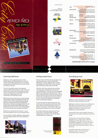
Pamphlet, Dept of Planning and Development, "Catch the City Circle", 1994
Pamphlet - DL 6 fold from A3 sheet, full colour titled "Catch the City Circle", detailing the City Circle tram, 1994 - has the original route by Spencer St - map shows various points and details the various locations.. Has contact details but no web site. Has the Victoria government, Better Cities and Public Transport Corporation Logos. See Reg Item 866, 2703 and 1337 for other versions. Second copy added 24-04-2019 from Bob Prentice Collection.trams, tramways, city circle, yarra trams, ptc -
 Melbourne Tram Museum
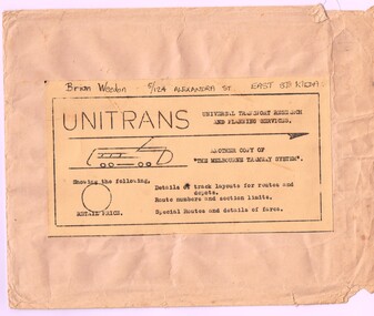
Map, Russell J. Nowell, "The Melbourne Tramway System", mid 1960's
Printed map (dye line process) on a large sheet of paper contained within an envelope. .1 - Brown paper envelope with a printed sheet glued to the envelope - giving title "The Melbourne Tramway System", publisher ("Unitrans - Universal Transport Research and Planning Services" - with a space for the retail price. .2 - Map printed on paper and folded into 16 parts - details the track layouts for routes and depot, route numbers, sections, Latrobe and William St services and details of fares. Has a sketch of tram 980 in the top right hand corner along with details of the tram system. Also includes depot locations, reserved tracks and derails at level crossings, though railway level crossings are not shown. Produced by Russell J. Nowell - gives address and phone number along with the "UniTrans" logo. Advised by other members, he was a Tasmanian. Not dated, but appears to be mid 1960's. Plan scanned 1-3-2016 as a tiff file.Envelope has the name and address of the donor "Brian Weedon 5/124 Alexandra St East St Kilda"trams, tramways, map, mmtb, depots, tram routes, trackwork -
 Melbourne Tram Museum
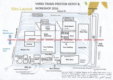
Document - Plan, Yarra Trams, "Yarra Trams Preston Depot & Workshop - Site Layout", 2016
A4 colour printed copy of "Yarra Trams Preston Depot & Workshop - Site Layout", produced prior to the formal opening of the depot on 17/4/2016. Shows the various buildings, tracks, locations. Provided by John Prideaux form the site induction document - notes that some of the eastern and western fans track layout various.See image for notes.trams, tramways, yarra trams, plans, preston workshops, preston depot