Showing 2635 items
matching map of victoria
-
 Bendigo Historical Society Inc.
Map - CAMPBELL COLLECTION: BENDIGO AND DISTRICT MAPS, 1982
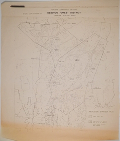
... Map. Forest Commission Victoria, Bendigo Forest District...MAP Bendigo forest district Map. Forest Commission Victoria ...Map. Forest Commission Victoria, Bendigo Forest District, Greater Bendigo Area. Shire of Marong, Sailors Gully, Epsom, Borough of Eaglehawk, Jackass Flat, White Hills, California Gully, Shire of Huntly, Maiden Gully, Long Gully, North Bendigo, Bendigo East, City of Bendigo, West Bendigo, Kennington, Shire of Strathfieldsaye, Flora Hill, Quarry Hill, Golden Square, Kangaroo Flat, Spring Gully. Prevention Strategy Plan. Base prepared 1982.map, bendigo, forest district -
 Port Melbourne Historical & Preservation Society
Map - VACCUUM Road Guide to Victoria
... map. VACCUUM Road Guide to Victoria.... VACCUUM Road Guide to Victoria Map VACCUUM Road Guide to Victoria ...The Mathews family have been in continuous ownership of 395 Howe Parade (was 8 Howe Parade until 1964 when addresses re-assigned), Port Melbourne from 1938 to the present (Sept 2019)Six folders of assorted documents relating to the life of Alan Mathews and his family. Employment documents. Folder 4 has Motor car purchases, Registration, Licences & RACV Road map. VACCUUM Road Guide to Victoriatransport - motor vehicles, alan mathews, commonwealth aircraft corporation, cac -
 Bendigo Historical Society Inc.
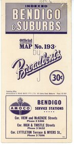
Map - Three Road Maps of Bendigo, 1962
... with difficulty'. It was to become Victoria's standard map, and the basis.... Next year he issued a road map of Victoria, 'prepared … after ...George Robert Broadbent (1863-1947), cyclist and map publisher, was born on 3 November 1863 at Ashby near Geelong, Victoria, son of George Adam Broadbent, Lancashire-born draper, and his wife Elizabeth, née Ruffhead. When the family moved to North Melbourne Broadbent attended the Errol Street school, followed his father's trade, and became an early cycling and cycle-racing enthusiast. At various times Broadbent held most Victorian and Australian road records, and two of his performances on solid tyres—203 miles (327 km) in 24 hours on a penny farthing, and 100 miles (161 km) in 6 hours 20 minutes on a 'safety' bicycle—were never bettered. He established records for all distances between 130 and 220 miles (209 and 354 km), and for all times between 8 and 12 hours, at the Exhibition Grounds track in May 1894, and road records for 50 and 100 miles (80 and 161 km) in October 1896. The Australian Cyclist acknowledged him 'the finest road rider that Australia has ever produced'. A foundation councillor of the League of Victorian Wheelmen in October 1893, Broadbent contested the first Warrnambool-Melbourne race in 1895, and was active in the Good Roads Movement. Next year he issued a road map of Victoria, 'prepared … after some sixteen years riding and touring in all parts of the Colony', which indicated general topography, distances, and roads classified as 'good', 'fair' or 'ridden with difficulty'. It was to become Victoria's standard map, and the basis of a continuous publishing programme by Broadbent's Official Road Guides Co.Three Road Maps of Bendigo, Bendigo and Suburbs, Bendigo and Eaglehawk. Two fold out maps printed in colour and produced by Broadbent's Road Maps Pty. Ltd. 475 Collins Street Melbourne. One map printed by Bolton's Bendigo.history, bolton's, bendio broadbent maps -
 Bendigo Historical Society Inc.
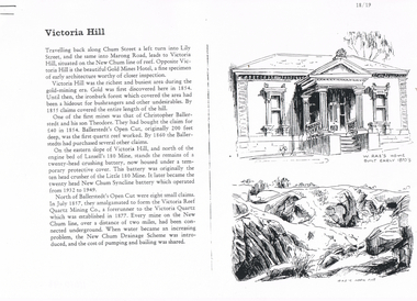
Document - LONG GULLY HISTORY GROUP COLLECTION: VICTORIA HILL
... a map of the Victoria Hill Area showing streets and the New Chum... page has a map of the Victoria Hill Area showing streets ...Three pages numbered 18/19, 20/21 and 22/23 titled Victoria Hill. First page has some information on Victoria Hill, a sketch of W Rae's Home and Rae's Open cut. The second page has a map of the Victoria Hill Area showing streets and the New Chum Anticline, a sketch of Ballerstedt's Open Cut and a Key to Victoria Hill Area Map. The third page mentions the Victoria Quartz mine, Tributors and quartz roasting. It also has sketch of a 20 Head Crushing Battery, Victoria Hill.bendigo, history, long gully history group, the long gully history group - victoria hill, gold mines hotel, christopher ballerstedt, theodore ballerstedt, ballerstedt's open cut, lansell's 180 mine, little 180 mine, new chum syncline battery, victoria reef quartz mining co, victoria quartz, new chum drainage scheme, a roberts and sons, tributors, william rae's bon accord mine and open cut, william rae, adventure and advance open cuts, central nell gwynne, heinz butcher shop -
Bendigo Historical Society Inc.
Map - CAMPBELL COLLECTION: BENDIGO AND DISTRICT MAPS, 1982
... Map. Forest Commission Victoria, Bendigo Forest District... Bendigo forest district Map. Forest Commission Victoria, Bendigo ...Map. Forest Commission Victoria, Bendigo Forest District, Sub-Plan 1 District Fire Prevention Plan, Greater Bendigo Area. Prevention Strategy Plan. Shire of Marong, Shire of Huntly, Borough of Eaglehawk, Shire of Strathfieldsaye, Sailors Gully, Epsom, Jackass Flat, White Hills, California Gully, Maiden Gully, Long Gully, North Bendigo, City of Bendigo, Bendigo East, Kennington, West Bendigo, Golden Square, Quarry Hill, Flora Hill, Spring Gully, Kangaroo Flat.Base prepared 1982. (number 397 in map cupboard 1)map, bendigo, forest district -
 Bacchus Marsh & District Historical Society
Map, Village allotments, Parish of Myrniong, County of Bourke
... A single page paper map. A cadastral parish map of Myrniong.... A cadastral parish map of Myrniong in Victoria, showing numbered land ...Myrniong is a village 9 kilometers west of Bacchus Marsh. Prior to 1863 the area was known as Blow's Flat. This map which was produced in 1903 and according to the catalogue record of this map held at the State Library of Victoria was based on an earlier map created in 1861. The early layout of streets for the village of Myrniong can be seen on this map. The streets shown are, Main Street, Hardy Street, Blow Street, Myrniong Street, Shuter Street, and Blackwood Street. An area marked as a reserve for a school can be seen between Hardy Street and Main Street.A single page paper map. A cadastral parish map of Myrniong in Victoria, showing numbered land allotments. Photo-lithographed at the Department of Lands & Survey, Melbourne, in 1903. Based on an original map created in 1861. The map is pasted into a bound volume containing 76 maps or plans in total. High resolution digital image stored on BMDHS computer network. Surveyed by John Hardy, Surveyor ; photo-lithographed at the Department of Lands & Survey, Melbourne by T.F. McGauran, 24.12.03myrniong parish plan, myrniong parish maps -
 Bendigo Historical Society Inc.
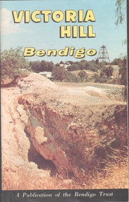
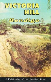
Book - VICTORIA HILL - VICTORIA HILL BENDIGO
... Booklet titled: 'Victoria Hill Bendigo A Publication.... There are also two maps, History of Victoria Hill and geographical notes ...Booklet titled: 'Victoria Hill Bendigo A Publication of the Bendigo Trust'. Booklet has photos of the Central Nell Gwynne Mine, Victoria Hill in the 1860's, with Rae's Battery in the foreground, geographical features, Rae's Open Cut, Victoria Hill from the New Chum Hill in the 1870's, compressor beds, The Victoria Quartz Mine, burnt ground from quartz roasting, the remains of a twenty head crushing battery, a view from Ballerstedt's Open Cut showing the historic Gold Mines Hotel built in 1857 and the engine beds of Lansell's '180' mine. There are also two maps, History of Victoria Hill and geographical notes on the area.book, bendigo, victoria hill -
 Flagstaff Hill Maritime Museum and Village
Document - Map, Department of Lands & Survey, Victoria / Port Campbell, 1942
... This Emergency Edition of the map of Port Campbell...Military map of Port Campbell, Victoria, Australia; part.... Victoria / Port Campbell Document Map Department of Lands & Survey ...This Emergency Edition of the map of Port Campbell, Victoria, is part of the W.R. Angus Collection. It was printed in 1942 during World War II. It is one of two maps donated to Flagstaff Hill Maritime Village by the family of Doctor William Roy Angus, who served as Surgeon Captain in the Australian Defence Department. The map was compiled for the Dept. of Army by the Dept. of Lands and Survey in Melbourne, prepared by the Australian Section of the Imperial General Staff, which was a British Government body created in 1907 to co-ordinate the defence of Britain and its Empire. It was printed by A.H.Q. Cartographic Company, Survey Corps, which was formed in 1941. The Corp changed its name to L.H.Q. Cartographic Company of Bendigo. In 1947 the name reverted back to the A.H.Q. Cartographic Company until 1955 when it became the A.H.Q. Survey Regiment. The W.R. Angus Collection includes historical medical equipment, surgical instruments and material once belonging to Dr Edward Ryan and Dr Thomas Francis Ryan, (both of Nhill, Victoria) as well as Dr Angus’ own belongings. The Collection’s history spans the medical practices of the two Doctors Ryan, from 1885-1926 plus that of Dr Angus who began practice in 1924. Dr Angus served with the Australian Department of Defence as a Surgeon Captain during the Second World Was from 1942 to 1945. He served in Ballarat, Victoria, and in Bonegilla, N.S.W. until he suffering from a heart attack just before the war ended. ABOUT THE “W.R.ANGUS COLLECTION” - Doctor William Roy Angus M.B., B.S., Adel., 1923, F.R.C.S. Edin.,1928, was generally known as Dr Roy Angus. His working life included a position as a doctor with the Flying Doctor Service in Australia’s rural and remote areas. After many varied experiences Dr Angus and his family moved to Warrnambool in 1939 where he purchased “Birchwood,” the 1852 home and medical practice of Dr John Hunter Henderson. He was appointed on a part-time basis as Port Medical Officer in Warrnambool and held this position until the 1940’s when the government no longer required the service of a Port Medical Officer. Dr Angus was a surgeon at the Warrnambool Base Hospital 1939-1942. After further studies he commenced practice as an ophthalmologist in Warrnambool, pioneering in artificial eye improvements. He was Honorary Consultant Ophthalmologist to Warrnambool Base Hospital for 31 years and made monthly visits to Portland to perform eye surgery. Dr Angus and his wife Gladys were very involved in Warrnambool’s community with a strong interest in civic affairs. They were both involved in the creation of Flagstaff Hill Maritime Village, including the layout of the gardens. After his death on 28th March 1970 his family requested his practitioner’s plate, medical instruments and some personal belongings be displayed in the Port Medical Office surgery at Flagstaff Hill Maritime Village, and be called the “W. R. Angus Collection”. This Emergency Edition of the Map of Port Campbell is significant as an example of the documents prepared for the defence of Australia in World War 2. The Map is also significant for its connection between the Australian Army and the involvement of Dr WR Angus as a Surgeon in the Medical Services during World War II. The W.R. Angus Collection is significant for still being located at the site it is connected with, Doctor Angus being the last Port Medical Officer in Warrnambool. The collection of medical instruments and other equipment is culturally significant, being an historical example of medicine, administration, household equipment and clothing from late 19th to mid-20th century. Dr Angus assisted Dr Tom Ryan, a pioneer in the use of X-rays and in ocular surgery. The collection includes Dr Angus’s Army objects and is significant as an example of items issued to Doctors and Surgeons in the Medical Services of the Australian Army in World War IIMilitary map of Port Campbell, Victoria, Australia; part of the W.R. Angus Collection. Rectangular coloured map on cream paper for the Australian Army. Details include sea, waterways and land, contour lines, grid lines, names of districts, towns and roads, bridges, swamps, rail lines, cuttings, tracks, buildings (including blacksmiths), pumps, lighthouses, telegraph, telephones and electric transmission lines, and fire stations. The map has margin notes that include distances in miles to nearby towns. The map was compiled for the Dept. of Army by the Dept. of Lands and Survey in Melbourne, prepared by the Australian Section, Imperial General Staff and printed by A.H.Q. Cartographic Company, Melbourne in 1942. Crown Copyright Reserved. Inscriptions in red print state that it is and Emergency Edition and an Official document. An oval purple stamp includes the price.Printed in black; 'Victoria / Port Campbell", "No. 932 / Zone 6" Printed in red; “EMERGENCY EDITION”, “THIS MAP IS AN OFFICIAL DOCUMENT. IF FOUND, IT MUST BE HANDED / IN TO THE NEAREST MILITARY HEADQUARTERS OR POLICE STATION” Stamped: within concentric ovals (“- - - FOR SALE / PRICE 2/- / - - - - - OF THE ARMY”)flagstaff hill, warrnambool, flagstaff hill maritime museum, maritime museum, shipwreck coast, flagstaff hill maritime village, great ocean road, dr w r angus, dr ryan, warrnambool base hospital, nhill base hospital, flying doctor, surgeon captain, map port campbell 1942, roy angus, port medical officer, military map, emergency map, australian department of defence, royal australian army, military service australian army, department of army, department of lands and survey, world war 2, a.h.q. cartographic company melbourne, australian section, imperial general staff, port campbell 1942 -
 Glenelg Shire Council Cultural Collection
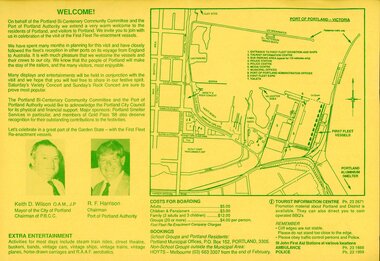
Programme - Programme - First Fleet Re-enactment Portland, Designed by Blue Wren Enterprises, P.O. Box 351, Portland, 3305, PORTLAND FIRST FLEET RE-ENACTMENT VISIT, March 1988
... . On the back cover is a square bordered map of Port of Portland... bordered map of Port of Portland Victoria, a welcome blurb, extra ...Double sided Brochure and programme of events for first fleet re-enactment at Portland, March 24 -28 1988. Yellow paper, green print. Illustration of 'Bounty' on front cover. On the back cover is a square bordered map of Port of Portland Victoria, a welcome blurb, extra entertainment, costs for boarding, and bookings information. Features headshots of Keith D. Wilson and R.F Harrison. first fleet, bounty, 1988, keith d wilson, r f harrison, port of portland -
 NMIT (Northern Melbourne Institute of TAFE)
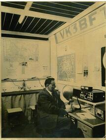
Photographs: CTC 1971 Amateur Radio Club VK3Bk and teacher John Wilson, Photographs: CTC 1971 Amateur Radio Club VK3Bk and teacher John Wilson
... , operating a radio. On the wall there is a VK3BF banner and maps... and maps of Australia and of Victoria. The photo is undated ...Black and white photographs. One of John Wilson, a teacher, operating a radio. On the wall there is a VK3BF banner and maps of Australia and of Victoria. The photo is undated but is referred to in Scott's history of Collingwood Technical School 'Coltech' and probably dates in the 1970s. The second photo is of members of the 1971 Amateur Radio Club of Collingwood Technical College Also Amateur Radio Club Membership Certificates for 1971 and 1981There is also a paragraph taken from Scott's history which records the development of the Club.collingwood technical school, radio station, vk3bf, nmit -
 Bendigo Historical Society Inc.
Document - JOAN O'SHEA COLLECTION: VICTORIA HILL GOLDMINING AREA BOOKLET, March 1972
... and Black and White Booklet 16 Pages. Includes Maps of the Victoria... Pages. Includes Maps of the Victoria Hill Area, photographs ...Joan O'Shea Collection. Victoria Hill Bendigo Gold Mining on the Richest Quartz Reef in Bendigo, from 1854 to 1916. Colour and Black and White Booklet 16 Pages. Includes Maps of the Victoria Hill Area, photographs of the remains of a twenty head crushing battery, burnt ground from quartz roasting, The Victoria Quartz Mine Photograph from Australian Mining Standard June 1899, The compressor beds and concrete foundations for the poppet legs all that remain today of the Victoria Quartz Mine deepest mine on Bendigo Goldfield 4613 feet or 1406.04 metres. Also included photograph of the view of Victoria Hill from The New Chum Hill in the 1870s. The Location of the 3 mines Ballerstedt's open cut, North Old Chum and Lansell's 180 are marked. A depiction of Rae's Open Cut gives an understanding of the primitive nature of early workings on the Goldfields. The Booklet also provides a brief history of Victoria Hill itself.Bendigo Trust Publication March 1972. Printed in Bendigo Cambridge Press.bendigo, mining, victoria hill -
 Bendigo Historical Society Inc.
Map - UNITED HUSTLER'S & REDAN MINE - TRANSVERSE SECTION UNITED HUSTLER'S & REDAN MINE
... 745.62 ft above sea level. Map has Geological Survey of Victoria... 745.62 ft above sea level. Map has Geological Survey of Victoria ...Transverse Section of the United Hustler's & Redan Mine on the Hustler's Line of Reefs Bulletin No 33, Plate No XXIX. Map has drawing of poppet legs on the surface, depth of levels, type of stone encountered and some geological features. Sill of shaft 745.62 ft above sea level. Map has Geological Survey of Victoria emblem and signed by H S Whitelaw, Underground Survey Office Bendigo, 'September 1913. mining, parish map, united hustler's & redan mine, hustler's line of reef, geological survey of victoria, h s whitelaw -
 Bendigo Historical Society Inc.
Map - K. K. MINE - TRANSVERSE SECTION K. K. MINE
... of Reefs, Bulletin No 33, Plate No XXXII. Map shows the different.... Mine Hustler's Line of Reefs Geological Survey of Victoria H S ...Transverse Section of the K. K. Mine on the Hustler's Line of Reefs, Bulletin No 33, Plate No XXXII. Map shows the different levels and their depth. Also, the different types of stone encountered and geological features such as spurs and faults. Has drawing of the poppet legs at the top of the shaft and sill of shaft 773.56 ft above sea level. Map has Geological Survey of Victoria crest and signed by H S Whitelaw, Underground Survey Office Bendigo, September 1913. miners, fortuna hustler's mine, transverse section of k. k. mine, hustler's line of reefs, geological survey of victoria, h s whitelaw -
Bendigo Historical Society Inc.
Map - BENDIGO, 1916
... , Laanecoorie. Price 3/-. Smaller map of State of Victoria. Lithographed..., Laanecoorie. Price 3/-. Smaller map of State of Victoria. Lithographed ...Map. Bendigo, Gunbower, Gladstone, Talbot, Dalhousie, Rodney, Jarklan, Calivil, Hayanmi, Mitiamo, Wanurp, Pannoobamawm, Bamawm, Millewa, Ballendella, Janiember West, Janiember East, Pompapiel, Talambe, Dingee, Milloo, Pannoomilloo, Rochester West, Yarrayne, Salisbury, Yallook, Tandarra, Kamarooka, Warragamba, Diggorra, Minto, Bridgewater, Yarraberb, Neilborough, Whirrakee, Egerton, Elmore, Nolan, Goornong, Bagshot, Huntly, Derby, Leichardt, Nerring, Tarnagulla, Woodstock, Marong, Sandhurst, Wellsford, Bendigo, Axedale, Strathfieldsaye, Eppalock, Kimbolton, Lyell, Sedgwick, Mandurang, Lockwood, Ravenswood, Shelbourne, Laanecoorie. Price 3/-. Smaller map of State of Victoria. Lithographed at the Department of Lands and Survey, Melbourne. 1916. Scale : Two miles to one inch. Map was in book form. (number 62 in map cupboard 1)map, bendigo, bendigo -
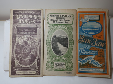 Kiewa Valley Historical Society
Maps - Tourist
... in red and blue. 3. Tourist Map of North Eastern Victoria.... Tourist Map of North Eastern Victoria including Bogong High Plains ...These maps were all dated 1933 which was before the construction of the Kiewa Hydro Electric Scheme and when Tawonga was spelt Towonga. North East Victoria in 1933 was before the construction of the Kiewa Hydro Electric Scheme so the townships of Mt Beauty and Bogong are not shown. The description of the Snow Lines was important as skiers, bushwalkers and campers relied on them. The details on the map include "ADB. Numbered from A.1-377 round plates. CD Numbered from C 1-235 square plates. Poles about 3 chains apart 27 to the mile." 3 Tourist location maps (folded) and printed on parchment. 1. Tourist map of the Dandenong Ranges. Brown cover. dated 6-4-33. Govt. printer showing roads, tracks in red and heights of the land. 2. Tourist Map of Warburton, Mt Baw Baw, and Walhalla. Blue and Orange cover. dated 23-5-33 Govt. printer. 3 different maps of each area showin roads, tracks and timber tramways.Also in red and blue. 3. Tourist Map of North Eastern Victoria including Bogong High Plains Mt Buffalo Etc. Green cover. dated June 1933 Govt. printer. Main map and insert titled Bogong High Plains. Showing roads , tracks and tram ways. On insert showing snow poles. Also Red and Blue and mountains.By Authority of H.J. Green - 6 pence. Dept of Lands and Survey, Melbourne1933 maps, tourism maps, bogong high plains map 1933, snow poles -
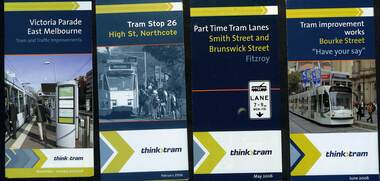 Melbourne Tram Museum
Pamphlet - Set of 8 Think Tram projects, VicRoads, 2005 to 2009
... include a small map of the works. 1 - Victoria Parade East... include a small map of the works. 1 - Victoria Parade East ...Set of 8 pamphlets detailing the proposed works and dates undertaken by VicRoads, Yarra Trams and the State Government. All include a small map of the works. 1 - Victoria Parade East Melbourne - 5 fold - 2005/2006 2 - Tram stope 26, High St Northcote - 3 fold - Feb. 2006 3 - Part time tram lanes Smith St and Brunswick St Fitzroy - 3 fold - May 2006 4 - Bourke St - have your say - 4 fold - June 2006 5 - Toorak Road tram terminus - 3 fold - Nov. 2006 6 - Bourke St tram stop construction - 4 fold - Sept 2007 7 - Elizabeth St at Queen Victoria Market platform stop - 2 fold - Nov. 2007 8 - Nicholson St - have your say - 4 fold - June 2009Demonstrates an information documents produced by Vicroads as part of the Think Tram projects.Set of 8 pamphlets - folded to DL printed on gloss paper.trams, tramways, vicroads, think tram, projects, roadworks, tram stops, toorak road, bourke st, high st, elizabeth st, nicholson st, victoria parade -
 Warrnambool and District Historical Society Inc.
Booklets Fletcher Jones, 001143.1 Project Book 001143.2 Booklet:Plusites 001143.3 Flyer, Mid 20th century
... throughout the book. A coloured map of Australia is in the middle... throughout the book. A coloured map of Australia is in the middle ...Fletcher Jones Clothing Factory was a key industry in Warrnambool from 1948 to its closure in 2005. The business was founded by David Fletcher Jones (1897-1977), a clothing manufacturer and retailer who worked as a hawker in the Western District following service with the A.I.F. in World War One. In 1924 Fletcher Jones opened three shops in Liebig Street selling men’s wear, hosiery and linen and operating a small tailoring business. He moved his shop to another location in Liebig Street and began to concentrate on men’s trousers production. In 1946 he opened a shop in Collins Street in Melbourne and eventually had stores and factories all over Australia. In Warrnambool he opened his factory at Pleasant Hill in Flaxman Street in 1948 and became a major Warrnambool employer, with over 1000 employees at one time. He transformed his business into a co-operative, with the name, ‘Fletcher Jones and Staff’ registered in 1947. The business diversified into other ranges of clothing for men and women but failed to compete with cheaper overseas clothing imports and the factory and shops were closed in the early 21st century. 001143.1 Project Book. This project book tells the story of the establishment and development of the Fletcher Jones company across the various stores which were established in Melbourne, Adelaide, Sydney, Geelong and Hobart. It explores the philosophy behind the business and milestones achieved and the factory gardens. The book itself provides an example of schoolwork completed in the mid 20th century. 001143.2 Booklet: Plusites: This is a staff booklet which has items of interest relating to staff such as births deaths and marriages. It tells of renovations and happenings in regard to the various shops around the country as well as trading figures. It tells of the royal visit of 1954 and other social events and items of interest around the various shops. 001143.3 Flyer :The text on this flyer also tells the story of the development of the Fletcher Jones brand to the point where there in the year2000 retail expansion was still happening but the Warrnambool workforce had shrunk from over 1000 at the peak to approximately 200. The company had commenced importing a range of clothing by this time These three items present different views of a company which was an important part of industry in Warrnambool for over 60 years in the latter part of the 20th century. The founder was one of Warrnambool’s most well respected people and many district people had connections to the firm. 001143.1 Project Book. Brown mottled card cover with cream insert for personal details. Back cover plain cream. It contains a student’s project work on the Fletcher Jones company. Some is handwritten and also contains a number of black and white photographs throughout the book. A coloured map of Australia is in the middle pages. 001143.2 Booklet: Plusites. White light card cover with dark blue text and diagram. Bottom left of page has a map of the coastline of Victoria. 20 pages. 001143.3 Flyer. Advertising Flyer re factory direct sales at Warrnambool. Black text with maroon border and Fletcher jones logo at the bottom and 4 photographs at the top. 001143.1 Project Book. T Cronin 4B WHS 001143.2 Booklet: Plusites. Vol 1 No 1 June 1954. 001143.3 Flyer fletcher jones, warrnambool history, fletcher jones and staff pty ltd -
 Bendigo Historical Society Inc.
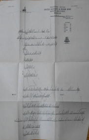
Document - MCCOLL, RANKIN AND STANISTREET COLLECTION: SUNDRY REPORTS, 1930's
... . Map with lines of reef showing the position of the New Moon.... Map with lines of reef showing the position of the New Moon ...Manilla Folder containing reports from various mines in Bendigo and surrounding areas. 1. 4 page typewritten report on the Balaclava Hill Mine at Rushworth and some newspaper clippings about the mine with a plan of the underground workings; 2. Page from the Árgus' dated 2nd August 1900 featuring an article on the survey of the Garden line of Reefs; 3. 5 page report with maps on the Tooleen Gold Field; 4. Single page report about an unnamed mining area claimed to be on the southern end of the Deborah line of reef. (this could be the 'Three Jays' mine in Sedgwick. P. Wilkin); 5. Hand written report on the Coronation Mine, 2 miles east of Walhalla.; 6. Hand written report dated 1935, of the Queen Mary mine, St. Arnaud.; 7. 1932 report on the North Neangar lease.; 8 4 page report on the Kings Prize Gold Mining Syndicate.; 9. Description of the plant of the Marong Alluvial Company? Also a guide for marking out leases.; 10. Crushing details (1 page) from the 'Enterprise' Mine South of and adjacent to Perseverence.; 11. 1 page crushing details from Rowe Brothers, Mosquito Mine, Fryerstown.; 12 hand written report mentions Arthur Hatfield, Scarsdale.; 13. Map with lines of reef showing the position of the New Moon Consolidated and the New Moon United shafts.; 14, Large scale map from Harrison/Victoria street to Havilah Road showing the positions of the Carlisle, North Garden and Unity Shafts.gold mining, miners' safety cage, sundry reports, mining. bendigo, rushworth, balaclava hill, garden line of reef, toolleen, coronation mine, walhalla, queen mary mine, st. arnaud. north neangar, kings prize gold mining syndicate, marong, enterprise mine, perseverence, rowe brothers, mosquito mine, fryerstown, arthur hatfield, scarsdale, new moon consolidate, new moon united, carlisle, north garden, unity. -
 Bendigo Military Museum
Photograph - Detachment - Army Survey Regiment, Bonegilla, Victoria, c1973
... the Detachment - Army Survey Regiment taken in front of its main map... Survey Regiment taken in front of the main map production... the Detachment - Army Survey Regiment taken in front of its main map ...This is a set of six photographs of personnel from the Detachment - Army Survey Regiment taken in front of its main map production building at Bonegilla, Victoria in c1973. This cartographic map production sub-unit of the Army Survey Regiment operated in buildings owned by the School of Military Survey from 17th of June 1970 to the 30th of September 1985. A total of 800 topographic maps ranging in scale from 1:25,000 to 1: 250,000 scale were completed. A major focus of production in the 1970s was the cartographic completion of the Papua-New Guinea 1:100,000 map series and the Flexiflow quality control system was developed as a tool to coordinate production. The Flexiflow system comprised a series of job plans and charts linked to a task allocation to resource magnetic planning board. Using critical path analysis and task prioritisation, complex job planning was efficiently scheduled, and re-prioritisations readily made. Reproduction requirements were effectively coordinated by way of weekly courier to the Army Survey Regiment at Bendigo. Supervisors and technicians fully embraced the system as they could understand their role, others around them and the positive production achievements. WO1 Bill Boyd (who does not appear in this photograph) was the technical warrant officer for 11 years at the Detachment was awarded the OAM, the Order of Australia Medal for leading the development and the implementation of the Flexiflow system. By mid-1982, production of maps at these scales was undertaken digitally on Bendigo’s AUTOMAP 2 system and the Detachment reverted to production of small-scale large format RAAF aeronautical charts. Detachment personnel managed to produce 18 charts in the following two years, which was an impressive achievement for the staff, given major differences in format, specification and scales. Development of digital production of aeronautical charts in 1984-85 led to gradual reduction in production output and contracting out production was instigated to meet the shortfall and as a consequence the Detachment closed in September 1985. See pages 177 to 180 of Valerie Lovejoy’s book 'Mapmakers of Fortuna – A history of the Army Survey Regiment’ ISBN: 0-646-42120-4. for more information on the history of the Detachment at Bonegilla.This is a set of six photographs of the Detachment - Army Survey Regiment taken in front of the main map production building at Bonegilla, Victoria in c1973. The photographs were printed on photographic paper and are part of the Army Survey Regiment’s Collection. The photographic print and proofs were scanned at 600 dpi. .1) to .3) - Photo, black & white c1973. Back Row L to R: Peter Simpson, Chris Edwards, unidentified (x2), Colin Harden, Rowan Gillies, Bob Rowley OAM, Steve Hansen, Stu Thaxter. Centre Row L to R: Kevin Boehm, Dennis McCarthy, Peter Cross, unidentified, Brian Ryan, unidentified, Ian Marner, unidentified, Phil Smalley. Front Row L to R: Geoff Haynes, Bruce Wetzig, Dave Thompson, unidentified, OC Bob Roche, Ike Lever, John McCulloch, Dick Barwald, unidentified. .4) - Photo, black & white c1973. Back Row L to R: Peter Simpson, Chris Edwards, unidentified (x2), Colin Harden, Rowan Gillies, Bob Rowley OAM, Steve Hansen, Stu Thaxter. Centre Row L to R: Kevin Boehm, Dennis McCarthy, Peter Cross, unidentified, Brian Ryan, unidentified, Ian Marner, Phil Smalley, unidentified, Dick Barwald. Front Row L to R: Geoff Haynes, Bruce Wetzig, Dave Thompson, unidentified, OC Bob Roche, Ike Lever, John McCulloch, unidentified (x2). .5) - Photo, black & white c1973. Back Row L to R: Geoff Haynes, unidentified, John McCulloch, Bruce Wetzig. Front Row L to R: Dave Thompson, Ike Lever, unidentified. .6) - Photo, black & white c1973. L to R: OC Bob Roche, unidentified.There are no personnel annotated.royal australian survey corps, rasvy, army survey regiment, detachment - army survey regiment, army svy regt, asr -
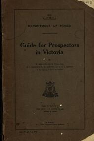 Federation University Historical Collection
Book, Guide for Prospectors in Victoria, 1931, 1931
... Grey soft covered book of 90 pages. Includes fold out map... Grey soft covered book of 90 pages. Includes fold out map ...The handbook was intended for those with little experience who wanted to prospect of fossick.Grey soft covered book of 90 pages. Includes fold out map of a portion of Victoria showing auriferous areas and mineral localities. Also show Counties of Victoria and localities of minerals such as tin, antimony, copper, silver lead, Malybdenite, tungsten ores, manganese, platinum, osmiridium and iron. Chapter heading s include: working alluvial deposits, equipment, geology of Victoria, gold deposits, quartz reefs, indicators, economic minerals, assistance to prospectors, Miners' Right, mining bye-law, mining leases, forest regulations and glossary. Descriptions are given of a god dish, puddling tub, cradle, puddling machine, ground sluicing, boring, windlass, whim, hand dollying, sweeping, California pump, and wing dam.mining, baragwanath, gold, prospector, geology, quartz reefs, alluvial deposits, indicators, victorian goldfields, miners rights, mining leases, forest regulations, sluicing, sluice box, puddling machine, miner's cradle, whim, whip, california pump, gold nuggets, saddle reef, ballarat indicators, state batteries -
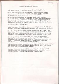 Bendigo Historical Society Inc.
Document - NEW CHUM LINE OF REEF MUNGO GROUP EAGLEHAWK
... . Victoria Street and Upper Road marked on the map. 'Between... in the earlier days. Small map on second page shows the location ...Two page document detailing the Mungo Group of Mines along the New Chum line of reef, Eaglehawk. The mines described are: Ellenborough, 2100 feet deep St Mungo, 2,600 feet deep The Lady Barkly, 1,350 feet deep, close to Upper Road with a 40 head battery on the other side. South St Mungo, known as the Governor Barkly in the earlier days. Small map on second page shows the location of the Sadowa shaft, St. Mungo shaft and the Lady Barkly shaft. Victoria Street and Upper Road marked on the map. 'Between Caldwells Road and Victoria Street and Upper Road intersection, nine mines and three crushing batteries worked at one period. All on the New Chum line of reef.' Not signed but most probably written by Albert Richardson.bendigo, mining, mungo group of mines, eaglehawk -
Surrey Hills Historical Society Collection
Work on paper - Vertical file, Armitstead family
... Victoria map of Surrey Hills including Union Road from Bedford... the following documents: 1. Land Victoria map of Surrey Hills including ...The Armitstead family's first woodyard in Surrey Hills was located in Croydon Road but later they moved to 153-157 Union Road, Surrey Hills. The business delivered timber and briquettes for heating to homes in the local area but also blocks of ice in the days before refrigerators were a usual household appliance. The timber was unloaded from railway trucks at a siding at Surrey Hills station; some came from the Armitstead's property of 130 acres of timbered land near Killara. They also sold mallee roots and briquettes.A vertical file containing the following documents: 1. Land Victoria map of Surrey Hills including Union Road from Bedford Street to Montrose Street, showing location of woodyard (undated) (1 A3 page). 2. Possibly ‘Sun’ article ‘When Surrey Hills ran short of wood’, Michael Sefton (undated) (1 page). 3. Plaque for the red mechanism of the weighbridge at Centre, by convenor, Surrey Hills Heritage Group, 12.11.2002 (1 page). 4. Pooley and Sons weighbridge, notes by Dennis Armstrong, in email to Sue Barnett, 4.4.2013 (2 pages). 5. Laminated diagram and notes by Ken Hall re weighbridge from Armitstead’s woodyard, and photocopy, undated (3 pages). 6. ‘Armitstead’s woodyard’ 153-7 Union Road (now Neighbourhood Centre), typed Progress Leader article, 13.1.1982 (2 pages). pooley and sons weighbridge, armitstead family, woodyard, armitstead's woodyard, union road -
 Warrnambool and District Historical Society Inc.
Booklet - Warrnambool Visitor's Handbooks 1979-2024, Collett, Bain and Gaspar, Printers, 1979-2014
... is a small map of Australia locating Victoria and the part... guides warrnambool maps [.1a] Warrnambool The Heart of Victoria's ...This is a collection of eight Warrnambool Visitor handbooks produced between 1979 and 2014 by the City of Warrnambool Tourist Information Centre. They contain maps of Warrnambool, lists of services, accommodation and tourist attractions as well as many advertisements for local businesses.These handbooks give a useful snapshot of businesses and tourist attractions in Warrnambool for each of the years covered. (1979, 1980, 1986, 1990, 1993, 1994, 1995, 2014)[.1a] A 48 page booklet with white pages and blue printing. The front cover has a coloured photograph of Flagstaff Hill with boats on a man made lake in the foreground looking across Lake Pertobe toward South Warrnambool. [.1b] A coloured bifold brochure. The front cover has a fisherman on a cray-boat holding a crayfish in the lower section. The top quarter has a blue back ground with white printing. The rear cover is red and has small photos of the Hopkins River and the Framlingham Forest. [.2] A 48 page booklet with white pages and black printing. The front cover is white with black writing on the left hand side and a colour photograph of the Loch Ard peacock. The Warrnambool Premier Town stylised logo of seven Norfollk pines above blue waves is in the top right hand corner. There is a blank ink Warrnambool Library stamp underneath the logo. The rear cover has photographs of The Twelve Apostles and the Hopkins Falls and the Premier Town Logo [.3] A 40 page booklet with mainly black printing on white paper. There are three fold out maps of Warrnambool and the surrounding district. The glossy cover has a black background with a colour photograph of the Twelve Apostles taken at sunset. The rear cover has three small of Proudfoot's boathouse on the Hopkins River, Flagstaff Hill, and the main beach area. The front cover has black writing inside to peach coloured rectangles. The inside rear cover has a fold out coloured tour map of Western Victoria. [.4] A 40 page booklet printed on glossy white paper with coloured photographs and black and red printing. The front cover has a photograph of The Twelve Apostles surrounded by a white border. There is red writing in the upper border. There is a sandy coloured writing superimposed across the bottom of the photograph and a Victoria's Shipwreck Coast logo in the bottom right hand corner. [.5] A 44 page booklet printed on white paper with black printing. The cream coloured cover has a pale red rectangle with blue writing on the right hand facing edge and includes two stylised Norfolk pines and with waves underneath. There is is an intersecting blue rectangle with cream printing. [.6] A 48 page booklet printed on white paper with black printing. The cover is brown with a cream vertical strip containing black writing on the right hand side. There is a stylised map from Geelong to Mount Gambier showing the Great Ocean Road across the cover. [.7] A 48 page booklet printed on white paper with black print. The glossy colour cover has a photograph of a Southern Right whale fluke. There is white printing on a the blue background of the sky and sea. The bottom left hand side of the front cover has a Tourism Victoria logo made of jigsaw puzzle pieces. The back cover has a stylised coloured map of The Great Ocean Road located in a white rectangle at the top of the page. Within the rectangle is a small map of Australia locating Victoria and the part of Victoria covered by the map. [.8] A 64 page A5 coloured booklet printed on white pages with black print. The white front cover has black and grey print with a colour photograph of two people holding coffee cups watching four race horses being exercised on the beach and in the water of Lady Bay in the early morning. The bottom right hand corner has a Tourism Victoria logo. The rear cover has a mainly blue back ground with a pink orange and green colour splats contains words advertising the 2015 Fun 4 Kids Festival [.1a] Warrnambool The Heart of Victoria's Great Southwest Visitor's Handbook [.1b] Warrnambool City for all seasons; The Heart of Victoria's Great Southwest [.2] Warrnambool visitor's handbook Warrnambool Premier Town 1979-1982 [.3] Warrnambool Handbook Victoria [.4] Warrnambool The Shipwreck Coast [.5] Welcome to Warrnambool Warrnambool Visitors Handbook 1993-1994 [.6] Welcome to Warrnambool Visitors Handbook 1994-95 Rear cover: Warrnambool Centre of Victoria's Shipwreck Coast on Australia's Great Ocean Road [.7] Warrnambool Shipwreck Coast - Great Ocean Road; You'll love every piece of Victoria; Visitors Handbook [.8] Warrnambool Great Ocean Road Official Visitor Guide; It's a wonderful Warrnambool; You'll love every piece of Victoria visitvictoria.com. Rear Cover Live entertainment.Workshops.Creativity.Action 28 June - 5 July 2015 Australia's Best Children's Festival F4K The ultimate winter school holiday adventure Fun 4 kids festival Warrnambool For more information visit Fun4kids.com.au Warrnambool great Ocean Road Victoriawarrnambool, visitor handbooks, tourist information guides, warrnambool maps -
 Bendigo Military Museum
Photograph - Johnson Ground Elevation Meter (JGEM) Survey Vehicle - Army Survey Regiment, Fortuna, Bendigo, c1960s
... :250,000 scale map blocks over northern Victoria and central NSW...:250,000 scale map blocks over northern Victoria and central NSW ...This is a set of 16 photograph of the Royal Australian Survey Corps’ Johnson Ground Elevation Meter (JGEM) Survey Vehicle taken at the Army Survey Regiment, Fortuna, Bendigo. The JGEM vehicle was extensively used by RA Svy within Australia from the late 1960s. A limited number of Ground Elevation Meter (GEM) station wagon type vehicles were manufactured by General Motors Corporation (GMC) in the USA for the United States Geological Survey, Canada’s mapping agencies, RA Svy and National Mapping (Natmap). The GEM was a four-wheel drive, four-wheel steer vehicle. Four-wheel steering was necessary to avoid systematic errors caused by non-tracking of front and rear wheels on conventionally steered vehicles. The manufacturer substituted the rear axle with a front axle and connected them to form the four-wheel steering mechanism. The two Australian GEM vehicles, referred to as Johnson GEMs (JGEMs) were converted into right-hand drive. After delivery in 1964, acceptance Natmap and RA Svy testing and operator training was undertaken at the Army's School of Military Survey located at Balcombe, Victoria. A small fifth wheel was mounted on a cantilever arm suspension midway between the front and rear wheels on the right side of the vehicle. It was lowered to and raised from its operating position by use of a constant pressure air cylinder. A telescopic bar, suspended between the front and rear axles, provided the reference datum for the angle measurement. The wheel provided the velocity or distance signal through a pulse generator system. A sensitive pendulum mounted on this bar provided the angle measurement for each minute distance traversed. The JGEM contained electromechanical instruments used to determine relative elevations, by trigonometric principles, along a traversed path. These relative elevations were obtained through apparatus which measures the instantaneous angle of inclination of the road and the instantaneous velocity of the meter along such a path. Road routes over which the JGEM operated were planned so that each started and ended as near as practicable to an existing point of known elevation (formally referred to as a level traverse bench mark). The difference in height from the bench mark and the road surface alongside the JGEM’s fifth wheel was measured with a level and staff. Along each route, mapping control photo reference points where new elevation values were required were identified on aerial photographs. Under favourable conditions it was possible to survey as much as 160km in an ordinary working day. The first of RA Svy’s JGEM operations was undertaken in 1:250,000 scale map areas of Queensland. CPL John Hook was the JGEM’s main operator in the early 1970s undertaking operations covering 1:250,000 scale map blocks over northern Victoria and central NSW, each requiring 36 points (9 runs of photography and 4 points across. SPR Lyn Thompson and SPR Bob McDonagh teamed with CPL Hook on some of these JGEM operations. When RA Svy was integrated into the Royal Australian Engineers in 1996, the JGEM vehicle with the Survey Corps collection was donated to its museum. It is believed to be the last of the original manufactured fleet in existence. The JGEM has undergone extensive refurbishment to achieve roadworthiness and is currently housed at The Australian Army Museum of Military Engineering, Hoslworthy Barracks, NSW. It can be viewed by making an appointment with the museum’s curator.This is a set of 16 photograph of the Royal Australian Survey Corps’ Johnson Ground Elevation Meter (JGEM) Survey Vehicle taken at the Army Survey Regiment, Fortuna, Bendigo. The photographs were on 35mm slide film and were scanned at 96 dpi. They are part of the Army Survey Regiment’s Collection. .1) - Photo, colour, c1960s, Johnson Ground Elevation Meter (JGEM) Survey Vehicle .2) - Photo, colour, c1960s, JGEM instrumentation, on-board computer. .3) - Photo, colour, c1960s, JGEM instrumentation. .4) - Photo, colour, c1960s, JGEM instrumentation, on-board computer. .5) - Photo, colour, c1960s, JGEM tyre pressure controller .6) - Photo, colour, c1960s, JGEM rear doors, SGT Geoff Briggs. .7) - Photo, colour, c1960s, JGEM 5th wheel distance/angle measurement device in lowered position, SGT Geoff Briggs. .8) - Photo, colour, c1960s, JGEM 5th wheel distance/angle measurement device in lowered position. .9) & .10) - Photo, colour, c1960s, JGEM tyre pressure system, SGT Geoff Briggs. .11) - Photo, colour, c1960s, JGEM tyre pressure system. SGT Geoff Briggs. .12) - Photo, colour, c1960s, JGEM levelling scope, levelling staff, unidentified technicians. .13) & .14) - Photo, colour, c1960s, JGEM levelling scope, unidentified technician. .15) & .16) - Photo, colour, c1960s, probably survey operation adjusted height plotted on block base sheet. .1P to .16P - Some of the equipment is annotated on the frame of the 35mm slides.royal australian survey corps, rasvy, army survey regiment, army svy regt, fortuna, asr, surveying -
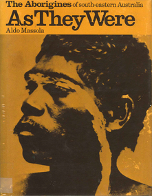 Victorian Aboriginal Corporation for Languages
Book, Aldo Massola, The Aborigines of south-eastern Australia : as they were, 1971
... , gives map showing locations of tribes, New South Wales, Victoria... Lake Victoria maps, b&w illustrations, b&w photographs Contents ...Contents: p.1-3; Origins, arrival in Australia; p.4-9; How they lived - camp sites, dating (including carbon dating); p.10-27; Physical appearance, skin colour, hair, clothing, body ornaments, cicatrization; exchange system, distribution of food, marriage &? sexual relations; the tribe - structure, relationship to land, territory, gives map showing locations of tribes, New South Wales, Victoria &? eastern South Australia, leadership, government, division of labour, status of women, estimated population at white settlement, density of population (Victoria); p.28-31; Language - names &? naming, reproduces Wembawemba vocabulary, notes use of secret languages, gives 12 rules for pronounciation; p.32-53; Religion, spirit beliefs, totemism, moieties, phratries, marriage rules; mythology, gives eaglehawk &? crow myth from Lake Victoria &? other myths illustrating origins of fire &? natural rock formations, mythical beasts (Bunyip, Mindie), stellar beliefs; magic, medicine men, powers, native remedies for sickness, describes ceremony held in Melbourne, 1847 to avert evil, sorcery, pointing bone, love magic, rain makers; messengers, appearance, etiquette, message sticks; p.54-71; Rock art, motifs, colours, decorative art, engraving of utensils, rock engravings, manufacture &? use of pigments, engraving techniques; trade system, objects bartered, meeting places for trade (Victoria), map shows possible routes (south east Australia); corroborees, purpose, body ornaments &? decorations, musical instruments; p.72-93; Ceremonial life, marriage, punishment for infidelity, birth, childhood, games &? amusements, initiation, etiquette of visiting tribes, details of ceremony, womens role, earth figures &? ground designs, bull roarers, female puberty ceremonies; p.94-133; Shelters, fire making, cooking, construction of canoes, wooden implements, use of reeds, animal skins &? sinews, shells; stone tools, cylindro conical stones, scrapers, knives &? microliths; hunting weapons, spear, other methods pits, nets; fishing methods &? spears, traps; food sharing, womens responsibilities for collecting, digging stick, cooking methods, insect foods, plant foods, water resources; manufacture &? use of spears, spear throwers, shields, clubs, boomerangs; inter- &? intratribal fighting; p.134-147; Death, disposal of body - eating of the dead, burial, cremation, platform exposure, dendroglyphs (N.S.W.), Aboriginal burial grounds (Darling &? Murray Rivers), mourning, widowhood, kopi caps (N.S.W.), causes of death, inquest ceremonies, revenge expedition, after death beliefs; p.148-157; The end of the tribes white settlement &? its impact on Aboriginal life, friction between natives &? settlers, establishment of Protectorates; copiously illustrated throughout.maps, b&w illustrations, b&w photographswemba wemba, murray river, darling river, lake victoria -
Federation University Historical Collection
Document, Zelda Martin, Central Victorian Goldmining towns - Boom Towns or Ghost Towns?, c1996
... - Historic Dunolly - Victoria's Best Kept Secret *Map of Gold... - Historic Dunolly - Victoria's Best Kept Secret *Map of Gold ...Zelda Martin was a PhD candidate at the University of Melbourne.[.1] 4th item in light blue display book titled Research Approach/Overview of Chapters/Confirmation of Canditure/Chapters1,2,3&4 of proposed thesis. *Twenty-seven page article on Victorian goldfields towns titled: Central Victorian Goldmining Towns - Boom Towns or Ghost Towns. The article was written during the author's PhD study. It outlines the context methodology, and resources and the chapters of the proposed thesis: (1) Central Victorian Goldmining Towns - The Context (2) Contemporary Views of the Factors Necessary for Town Growth (3) Outward Manifestations of Town Growth (4) The Trappings of Government (5-9) The Main Towns and Their Hinterland. [.2] 5th item in Light Blue display book as above item. *Chapter 1 of proposed thesis titled 'Pick, Shovel and Tin Dish Mining.' Covers in Section A: Central Victoria - Pre 1851: Aborigines in Central Victoria, Squatters, and Government. Section B: The years 1851-1854: The Early Gold Rushes, Government Reaction, Township Surveys, Legislation, Town Development, Local Government and Early Settlement. [.3] 6th item in Light Blue display book as above item. *2A of proposed thesis titled 'Contemporary Views of the Factors Necessary for Town Growth'. Similar information to Chapter 1 plus extra re towns and maps. Sections: Introduction, Context of Place - Geographical Towns Listed, The Context of Time - Pre1851 Aborigines, Governance of Port Phillip, The Squatters, The Villages of Central Victorian Highlands, Conclusion, Condensed Version of Chapter2B. [.4] 7th item in Light Blue display book as above item. *Chapter2B of proposed thesis. Sections: Area of Research, Schools, Banks, Newspapers, Progress Association, Town Development - Sandhurst (Bendigo), Ballarat, Castlemaine,, Maryborough, Ararat and Stawell. [.5] 8th item in Light Blue display book as above item. *Chapter 3 of proposed thesis titled 'Outward Manifestations of Town Growth'. Sections: Introduction, Contemporary Writing, Educationalists, The Bankers, The Townsfolk, Current Theory, General Theories of Urban Development, and Conclusion. [.6] 9th item in Light Blue display book as above item. *Chapter 4 of proposed thesis titled 'Trappings of Government' Sections: Introduction, Early Government Attitudes to Mining and Town Development, Law and Order, Township Surveys, Legislation, Local Government, Transport and Communication, The People and Lobbyists. [.7] 10th item in Light Blue display book as above item. *'The Rise and Fall of Central Victorian Goldmining Towns'. Includes a map showing main Goldfields, a table showing towns and villages at two points in time - 1857 and 1871; a Bibliography of Primary and Secondary Sources. [.8] Resource No1. Black display book titled Local Towns 1 : Alma: *Brief history *Directory *Maps Amphitheatre / Mountain Hut: *Brief History Post Office Directory Ararat: *Brief History *Post Office Directory 1869 - Alphabetical Listing by Occupation *Ararat - Prominent Citizens of 1858 *Langi-Morgala Museum Avoca: *Brief History *Excerpts from 'Avoca The Early Years', Margery and Betty Beavis; pg1 - Beginnings; pg11 - The Midas Touch; pg25 - Local Gold Escorts; pg27 - A Town is Born; pg51- The Administration of Justice; pg53 - The Ways of the Law; pg61 - News of the Day; pg65 - A Time to Play; pg72 - Land Ownership *Post Office Directory (Bailliere's) 1869 *Tourism Map and Information of area *Historic Avoca - A 5.5km Tour *Avoca & the Pyrenees Region - information pamphlet Ballarat: *Early History of Ballarat - Ballarat Historical Society, Publication No.1: origin of the name; Ballaarat - the Beginning; Fabulous Yields from the Ballaarat Goldfield; *Streetscape Lydiard Street. *Hand drawn map showing Leigh River, Old Portland Bay Road, plaque on road to Colac; etc. *Newspaper article re 'The Theatre Royal' ( which stood in the vicinity of the current Owen Williams store) - 'The News'15/04/1998 *Article - 'Ballarat's Mechanics' Institute Lives On' Ballarat Courier, 14/09/1985 *Article - Standing the Test of Time' The News 17/11/1993 re The Mechanics Institute & picture of the Reading Room *'Ballarat a Study of a City, Phyllis Reichl, pub. Nelson, 1968; no.3 place, time and people field studies series *Investigator Vol.33 No.2, 1998 Geelong Historical Society. Article on pg75 describes Ballarat in 1861 *Folded poster - 'Ballarat 100' a history of telegraph communication, pub. Telecom. Beaufort (Fiery Creek): *Brief history *Post Office Directory [.9] Resource No.2 Black Folder Titled Towns cont.No2 Bendigo (Sandhurst): *'Family & Local History at the Bendigo Library - 1851-2001 150 years of gold'. *Bendigo Government Camp in 1853 illustration; key to sketch and names of Government officers stationed there *Excerpts from 'Bendigo and Vicinity' Adolph Haman *The Bendigo Goldfield Registry - pgs 1-7 Introduction *Excerpt: 'Breaking the Grip' *Excerpt: The Most Go-Ahead Place *Excerpts from 'History of Bendigo' - anti license agitation; laying out of town; proposed railway; gold calls and dividends; the Sandhurst Municipality; journalism *Bibliography Blackwood: *Excerpts from 'Aspects of Early Blackwood - The Goldfield, the Landmarks, the Pioneers' Alan J Buckingham and Margaret F Hitchcock, JG Publishing,1980 Buninyong: *A Brief History *Investigator Vol1 No.2 Feb 1966 Geelong Historical Society. Pg3 - Article re gold escort route - Mt Alexander to Adelaide - (see a simple monument on the Western Highway a few miles out of Horsham. Pg 15 - Ballarat Excursion - re the finding of gold. *Three articles published by Buninyong and District Historical Society Inc: (Magpie Exploration; Finding Gold In The Green Hills; Magpie Exploration; Burnt Bridge to Cargarie to Mt Mercer) *Copies of newspaper articles/items *Buninyong Street Directory Carisbrook: *In the Beginning There Was Carisbrook *The History of the Carisbrook Racecourse Carngham / Snake Valley: *Brief History *Directory Castlemaine: *Directory 1865-1866 - Alphabetical and Street *Poster - Castlemaine A Contemporary Guide "The Great Centre" 1866 - A Contemporary Guide to the Fascinating Past *Pamphlet - Castlemaine District Community Hospital *Map - Castlemaine, Maldon & Surrounding Districts *Map and Information - The Dry Diggings Track - a 55kl walk among historic goldfields relics ( Castlemaine Fryerstown Vaughan Mt Franklin Hepburn Daylesford) *Postcard - Former Court House *Directory 1867 - Alphabetical, Trade [.10] Resource No.3 Grey folder Titled Towns 3 Creswick to Maryborough Creswick: *Brief History *Booklet - "Creswick Cemetery Walk" *Booklet - The Buried Rivers of Gold Heritage Trail Creswick *Creswick Historical Museum Information Sheet *Chronological History of Creswick *Alphabetical Directory of the Borough of Creswick *Creswick's Creek Directory 1856 *Historic Creswick Walking Tour *A Brief Account of the Schools of Creswick - Past and Present *100 Years of Railway Travel in Creswick *The Berry Deep Leads *The Spence Home at Jackass Gully in the Creswick State Forest ( William Guthrie Spence - Pioneer) *The New Australian Mine and the 1882 Disaster *Creswick District News, Issue 7, July August 1999 *The Creswick Miners Walk - Information and Map *Maps Chewton: *Brief History *Directory Clunes: *Brief History *Clunes Street Directory Daylesford: *Brief History *Notable Bushfires in Daylesford District Over More Than a Century - "Black Thursday" 1851; 1862; 1899; the Disastrous Hepburn Fire of 1906; 1939; 1944; 1969. *Post Office Directory -Daylesford and Hepburn Dunolly / Inkerman: *Brief History *Directory *Pamphlet - Goldfields Historical Museum *Pamphlet - Historic Dunolly - Victoria's Best Kept Secret *Map of Gold Workings at Dunolly Area - showing where the main gold rushes occurred *Brief History - Inglewood *Directory - Inglewood - Name Occupation, Dwelling Kingower: *Brief History *Directory - Name / Ocupation / Dwelling Linton / Happy Valley / Piggoreet: *Brief History *Directory - Lintons McIvor: *"A History of the Shire and the Township of Heathcote" by J.O. Randell Majorca: *Brief History *Official Post Office Directory 1869 - Name / Occupation/ Address Maldon (Tarrangower): *Brief History Part 1 *Brief History Part 2 *Post Office Directory *List - Alphabetical Order by Names plus Business and Trade (Tarrangower Times Oct/1858) *List - Alphabetical Order by Trade plus Name and Business *Directory - Name / Occupation / Dwelling Maryborough: *Worsley Cottage - built by Arthur Worsley, a contractor in stonework in 1894 [.11] Resource No. 4 Blue Display Book titled Towns 4 Moliagul to Stawell Moliagul: *Brief History *Moligul Legislative Assembly (Voting?) List - Names and Occupations *Moliagul Victorian Post Office Directory 1868 - Name / Ocupation / Address / Comments *"The Welcome Stranger" gold nugget *The Sunday School *The Welcome Stranger Discovery Walk - information and map Moonambel (Mountain Creek) Redbank *Brief History *List of names extracted from advertisments of the Pioneer and Mountain Creek Advertiser 16/02/1861. *Bailliere's Directory 1869 - Alphabetical List of Name / Occupation / Place St Arnaud: *Brief History Sebastapol: *Brief History *Directory 1869 - Alphabetical by Name; plus occupation and address. Browns and Scarsdale: *Brief History *Browns Street Directory - Name and Occupation Smythesdale: *Brief Description *Smythesdale Street Directory -Name and Occupation Stawell (Pleasant Creek) *Brief History *Victorian Official Post Office Directory - Name /Occupation / Dwelling *Chronology - 1841-1920 *Production of gold statistics - 1879 - 1900 *Big Hill *Extracts from "The Golden Years of Stawell". Chapt 1 - Stawell's Coming Out. Capt. 2 - The Gold Rush. Caapt.3 - Cradle of Democracy. Chapt.4 - The Reefs Becomes Stawell. Chapt. 5 - Rushing In. Chapt.6 - The Pioneers. Chapt 7 - The Decade of Optimism. [.12] Resource No. 5: Blue Display Book titled 'Towns Steiglitz to the The Golden Triangle. Steiglitz: Brief History Victorian Post Office Directory 1869 *Map of Steiglitz *List of maps relevant to Steiglitz history *Information 6 tables of data from "Reports of Mining Surveyors Talbot (Back Creek) Brief History Taradale: Post office Directory 1869 - Name/Occupation/Street. Also list in alphabetical order by Occupation Taradale *Chronological Reference to Taradale Mines *Water - The Coliban System of Waterworks *Joseph Brady *The Syphon Tarnagulla (Sandy Creek) *Brief History *Tarnagulla Businessmen Cameos to give depth to advertisments in 'The Tarnagulla Courier' various issues 1864-1871 *Directory - Name/Occupation /Address *List - Name/Business/Trade Wedderburn (Koorong) *Brief History *List - Name/Occupation The Golden Triangle: *The Early Rushes - Wedderburn / Moliagul / Sandy Creek - Tarnagulla / Jones Creek - Waanyarra / Kingower / Dunolly - Goldsborough / Inglweood *Census of 1857 - Population / Occupations *1858-1871 - A Time of Consolidation- Wedderburn / Moliagul / Sandy Creek- Tarnagulla / Arnold *Census 1871 - Population *Information gleaned from the census data - Demographics / Population / Occupations / marital / Birthplace / Religion / Literacy/ Occupation and Housing Cameos *Graphs - Birthplace of settlers /Male-Female Ratio / Married males / Children under 15 as Percentage of Population / Religion *Census 1857 - Statistical data *Maps *Bibliography [.13] Resource No. 6 - Black Display Book Information and Research in Central Victoria including: *Banking - Research from ANZ Bank Archives *Institutions - also includes articles listed from the Ballarat Times Newspaper *Australian mining History Association - A.M.H.A. Bibliography *Australia's Mining History * Bibliography - Land Surveys Victoria - *1853 Administration (Statistics and Other) includes: schools / ministers of religion / police / military / local administration / licences for sale of spirits / distances between various Victorian gold fields. * Victoria Government Gazette (Copy) - N0. 116, 12/12/1854 includes: Gold Felds Commission of Enquiry & No. 85, 15/09/1854 - Addresses presented to the Lieutenant Governor (Sir Charles Hotham) during his tour through the Gold Fields of Victoria,1854. Addresses on behalf of : the people of Bendigo; Members of the Church of England, Bendigo; Members of the Wesleyan Church on the Bendigo Gold Fields; Bendigo Gold District General Hospital; the Bendigo Prospecting Association; Committee of the Bendigo Local Exhibition; Bendigo District Medical Association; Coloured Americans Resident at Bendigo; German Inhabitants of Bendigo; Landowners, Inhabitants, and Miners of Castlemaine; Inhabitants of Forest Creek; Inhabitants of Heathcote and Gold Miners of McIvor; Residents and landholders of the District of Bacchus Marsh; Inhabitants of Kilmore and Vicinity. *Gold Fields Correspondence 1853: letter from Lieutenant Colonel Valiant, (Officer commanding the Troops in Victoria) to the Lieutenant Governor re threatened disturbance at Sandhurst (Bendigo) regarding the Gold License Fee. * Extracts from a book "Victoria" re Gold Fields Commission of Enquiry involving mainly Ballarat and Castlemaine and a chapter titled 'A Tour to the Victorian Gold-Fields' *Lists of central Victorian newspapers - listed by date published 1851to 1874; by first date available to State Library. *A list of cities and towns showing County, population in 1861 &1871, and municipal status. [.14] Resource no.7. Black display book. *Reference: Papers presented to Parliament Victoria - 1859-1860 4 volumes - relevant sections copied. Contains information on Branches of Government. General / Finance / Gold / Gazette / Commission and Warrant / Statistic. *Gold Fields Act. In accordance with the Act the gold fields are divided into six districts - Ballaarat, Castlemaine , Sandhurst, Avoca, Ararat, and Beechworth.. Official staff in each gold district consists of a Resident Warden, Wardens, Wardens' Clerks, Bailiffs, Chinese Protectors, Chinese Interpreters, and Mining Surveyors. *Gold Receiver *Gaols *Police magistrates and Clerks of Petty Sessions, etc. *Field Branch *Immigration and Emigration Overland - Chinese - 1859 *Population on the Goldfields *The Geological Survey - The Government Geologist is assisited by staff from four branches - the office Branch; the Publishing Branch; the Field Branch and the Museum Branch. *Commission to Enquire Into Sludge dated 10/02/1859 (Some sections copied) - Report to the Honorable Chief Commissioner of Public Works, Melbourne re the mode of carrying the sludge from the puddling mills in Sandhurst without interfering with the drainage of the town and the roads in the neighbourhood. [.15] Resource No.8: Camel display book titled Resource No. 8. Aborigines *Lists of book titles - +"Readings in Victorian prehistory" +"The Aborigines of Port Phillip" +Aboriginal languages and clans" +"A History of the Port Phillip District" +"Langi Ghiran 1: Aboriginal Rock...." +"Koorie History: sources for aboriginal studies in the State Library of Victoria", ed. Tom Griffiths, Melb. Friends of the State Library, 1989 +"The Public Lands of Australia Felix"; settlement and land appraisal in Victoria1834-91 with special reference to the Western Plains", J.M.Powell, Melb. Oxford University Press 1970 +*Bibliography of the Victorian Aborigines' from the earliest manuscripts to 31st December 1970, Massoa, Aldo, Melb. Hawthorn Press, 1971 +"Aborigines in Colonial Victoria, 1836-1886", M.F. Christie, Sydney University Press, 1979 +"Urban and Industrial Australia: readings in Human Geography" ed J.M. Powell, Melb. Sorrett Pub. 1974 *Extracts: -Processes of Pioneer Settlement - The Squatting Occupation of Victoria, 1834-60. J.M. Powell -Areal Variations in the Class Structure of the Central-Place Hierarchy. P. Scott - Volume1 and Volume 2: Notes Relating to the Habits of the Natives of Other Parts of Australia and Tasmania. Compiled from various sources for the Government of Victoria by R Brough Smyth. John Curry, O'Neil, Melb. 1st pub. Melb. 1876. p31-45 - Numbers and Distribution of the Aborigines in Victoria -Victorian Aborigines 1835-1901 - A Resource Guide to the Holdings of the Public Record Office, Victoria; published by the Government Information Centre 1984. *History of the Aboriginal Artefacts Displayed in the Daylesford Museum. F. G. Powell (4 page pamphlet) *Letter to Zelda Martin from Peter Lovett, Cultural Officer, Ballarat & District Aboriginal Co- Operative, 05/02/1997 *Map: Ian Clarke Victorian Tribunal Boundary Map - Clans of Central Victoria. *Victorian Rock Art and Mythology - Article about Mount Langhi Ghiran and myths of the Tjapwarong people. *Two Aboriginal myths relating to the Grampians - 'The Monster Emu' / 'The Aquisition of Fire', by the Aborigines in the Grampians Areas *Article titled (chapter 8) Ballarat - information re camping sites in the region. Lake Wendouree / Lake Burrumbeet (includes a myth) / Mt Bunninyong / Lal Lal / Pitfield / Mount Elephant / Mount Egerton / Meredith / Lake Goldsmith / Lake Learmonth / Ercildoune *Notes on the Aborigines of the Wider Ballarat Region plus European names=Aboriginal names. John Morris 26/07/1995 *Role of Aborigines in Town Development in Central Victoria. Mentions Native Police Force est. in Port Phillip 1842 and Central Board for Aborigines est. 1860 *The Grave of King Billy. (Frank Wilson) Pamphlet. *Camping Places in Central and Northern Victoria. Article re Lake Burrumbeet site. *Programme for the Unveiling of Memorial Cairn for Edward Stone Parker 1802-1865. Note portrait not accurate. Accurate portrait is available in the book "A Successful Failure A Trilogy The Aborigines and Early Settlers", Edgar Morrison, Graffiti Publications, 2002. * Large envelope addressed to Mr G Netherway containing newspaper cuttings regarding the life of Edward Stone Parker, the unveiling of the Memorial Cairn as mentioned above, articles titled 'Episodes from Our Early Days' (Edgar Morrison, Yandoit)- The Black's School, A School At Last and The Final years. Also a typed page titled 'Historical Background to E.S.Parker's Career. Includes an interesting tale titled 'When the cat lay doggo' re laying power leads for the unveiling ceremony at the memorial site. [.16] green display folder titled 'Research Aids' *List of references to Commissioners' & W'ardens' Reports (formerly held at La Trobe Library Archives, now at Public Records Office [PRO]). Indicates town referred to / date of report / name of camp if different to town. * Archive information re Anglican Records *Movement around the Goldfields - Miners and Storekeepers - usefulness of newspapers in providing information - areas covered - Castlemaine, Maldon, Ararat, Stawell, Tarnagulla, Dunolly. *Port Phillip /Victoria Directories 1839/1867 - Chronological list of Directories included in this series. *"Notes on the History of Local Government in Victoria" A.W. Greig Melb. University Press 1925 - Photo-copied extract p5-p40. (Source - Deakin University Library) - Introduction by W.Harrison Moore. Section 1 - Development in New South Wales Before Separation. Section 2 - Development in Victoria After Its Separation from New South Wales. Hand written notations: 'roads, markets, and local government 1855 on' ;'opportunity of squatters in parliament' and 'opportunities of matters in parliament p33' * Notes on the Establishment of Surveyor General's Department 1851and Commissioner of Crown Lands and Survey. * Newspaper articles from The Argus, 1849, re the discovery of gold in the Pyrenees region. * Excerpt - a report on schools - A.B.Orlebar, Inspector; re the need for permanent school buildings rather than tents. *Excerpt from - 'Approaches to Urban History', Sean Glynn: The Case for Caution * Except from - 'The Urban Sprinkle', Weston Bate: Country Towns and Australian Regional History *Reference- 'The History of Land Tenure in the Colony of Victoria', John Quick. References the Haines Land Bill, land tenure and Land Leagues. [.17] Light blue envelope folder titled 'Birtchnell's Ballarat, etc. Directory 1862 *Contains various directories for Smythesdale, Buninyong, Clunes, Brown's and Creswick. [.18] Red envelope folder no.2 titled Victorian Gazetteer *Selected pages from 1869 Victorian Gazetteer on A4 paper (with a handwritten note questioning if some pages are from 1868 Victorian Gazetteer as appears to be different sizes - A3 pages.) Information includes locations and descriptions of towns, hotels, banks, communications and populations. (Does not include names, residences and occupations) [.19] Red Envelope folder titled Bailliere's Official Post Office Directory 1868 (or1869 or a mixture of both?) *Preface *Contains a selection of pages of towns highlighted in yellow in the the index *Work on this directory was commenced in 1867. *Information includes: Municipalities - mayors and councilors; lists of towns naming male inhabitants and their occupations. [.20]Yellow manila folder titled Post Grad Seminar Presentation 1996 *Gives some background to Zelda Martin's proposed thesis and why she chose the topic Gold Mining Towns Boom or Bust [.21] A3 display book - No. 1A * A list of 'Relevant Newspapers collected: The Tarrangower Times and Maldon Advertiser (first published 1858) Includes dates 1858-1867. The Mount Alexander Mail. Includes dates 1854-1866 The Tarnagulla Courier. Includes dates from1864-1871 Dunolly and Burnt Creek Express. Includes dates from 1862-1871 * Selection of newspaper pages from The Mount Alexander Mail 1854 to 1856, mostly showing advertisements for businesses and services provided to that community. [.22] A3 display book - No. 1B * Selection of newspaper pages from The Mount Alexander Mail 1857 to 1866, mostly showing advertisements for businesses and services provided to that community. [.23] A3 display book -No. 2 * Selection of newspaper pages from The Tarnagulla Courier 1864 to 1871, mostly showing advertisements for businesses and services provided to that community. [.24] A3 display book - No. 3 *Selection of newspaper pages from The Tarrangower Times (and Maldon and Newstead) Advertiser 1858 to1867, mostly showing advertisements for businesses and services provided to that community. [.25] A3 display book - No.4 * Selection of newspaper pages from The Dunolly and Burnt Creek Express; and The Dunolly and Betbetshire Express 1862 to 1871, mostly showing advertisements for businesses and services provided for that community. [.26] A3 display book - No.5 Includes: * Bryce Ross's Diggings Directory. Includes instructions for using this directory. This directory was used by "all persons having connexion or desiring to communicate with 'working parties, private friends, or Stores at the Diggings." As a directory for each area wwas completed it was published in each month's issue of Bonwick's "Digger's Magazine." Years c1852/1853. This Directory commences first at the head of Forest Creek. Includes a directory for Bendigo and Ballarat. Of interest at the end of the Bendigo and Ballarat directory is a list of the number of storekeepers, butchers, doctors, smiths, eating houses, lemonade sellers and chapels. * The Castlemaine Directory and Book of General Information Comprehending Glass's Model Calendar for the Two Years 1862 and1863. "zelda martin, victorian goldfield towns, bendigo, castlemaine, ballarat, maldon, stawell, ararat, maryborough, creswick, avoca, heathcote, banks, bank of australasia, union bank of australia, government camp, sandhurst, water supply, tarnagulla, talbot, back creek, mountain creek, police court, carisbrook, dunolly, thompson's foundry, charles clacy, anthony trollope, robert cecil, mount alexander, urbanisation, national schools, education, govenrment, industry, railway, transport, settlement, land settlement in central victoria, steiglitz, joseph brady, the new australian mine, berry deep leads, william guthrie spence, creswick state forest, arthur worsley, worsley cottage, the welcome stranger, moliagul, moonambel, redbank, st arnaud, sebastapol, brown's, scarsdale, clunes, chewton, daylesford, bushfires, inkerman, inglewood, kingower, lintons, happy valley, piggoreet, mcivor, majorca, tarrangower, taradale, the coliban system, the syphon, sandy creek, wedderburn, koorong, arnold, jones creek, waanyarra, the golden triangle, census 1857, blackwood, buninyong, durham lead, magpie, carngham, snake valley, alma, amherst, daisy hill, amphitheatre, mountain hut, beaufort, fiery creek, counties, population, gold fields commission of enquiry1854, william westgarth, gold license fee, lieutenant colonel valiant, administration of the victorian gold fields, commission to enquire into sludge 1859, e.s. parker, edward stone parker, edgar morrison, mount franklin protectorate, dja dja wurrung, memorial cairn, franklinford, mt franklin memorial cairn, jajowurrong, dja dja wurung, tjaowarong, wothowurong, assistant protectors, daylesford museum, buluk, rock art - grampians, aboriginal mythology - grampians, aborigines, first nations people, mount franklin, aboriginal artifacts, lake burrumbeet, native police force, central board of aborigines, yandoit, commissioners' reports, wardens' reports, port phillip/victoria directories 1839-1867, local government - victoria 1853/1854, surveyor general's department - 1850's, victorian schools 1850's, a.b.orlebar, haines land bill, william charles haines, wilson gray, land tenure, land leagues, victorian gazetteer, the tarrangower times and maldon advertiser - 1858-1867, the mount alexander mail 1854-1866, the tarnagulla courier 1864, dunolly and burnt creek express 1862-1871, bryce rose's diggings directory, the castlemaine directory 1862-1863 -
 The Beechworth Burke Museum
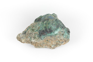
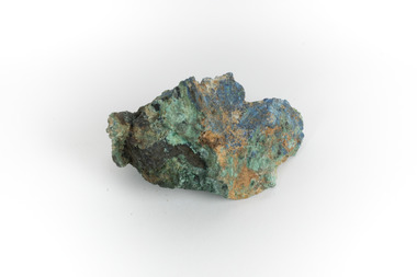
Geological specimen - Malachite, Unknown
... Rush) to study and map the geology of Victoria. Collecting ...Malachite is typically found as crystalline aggregates or crusts, often banded in appearance, like agates. It is also often found as botryoidal clusters of radiating crystals, and as mammillary aggregates as well. Single crystals and clusters of distinguishable crystals are uncommon, but when found they are typically acicular to prismatic. It is also frequently found as a pseudomorph after Azurite crystals, which are generally more tabular in shape. This particular specimen was recovered from the Burra Burra Copper Mine in Burra, South Australia. Otherwise known as the 'Monster Mine', the Burra Burra Copper Mine was first established in 1848 upon the discovery of copper deposits in 1845. Within a few short years, people from around the world migrated to Burra to lay their claim in the copper economy. By April 1848 the mine was employing over 567 people and supporting a population of 1,500 in the local township. Up until 1860, the mine was the largest metals mine in Australia, producing approximately 50,000 tonnes of copper between 1845 to its closure in 1877. The Burra Burra Mine was also famous for a number of other specimens, including; crystalline azurite, cuprite, and botryoidal and malachite. Malachite is considered a rare gemstone in that the original deposits for the stones have been depleted leaving behind very few sources. In addition, the use of Malachite as gemstones and sculptural materials remains just as popular today as they were throughout history. It is quite common to cut the stone into beads for jewellery. The fact that Malachite has such a rich colour and one that does not fade with time or when exposed to light makes it particularly rare. This specimen is part of a larger collection of geological and mineral specimens collected from around Australia (and some parts of the world) and donated to the Burke Museum between 1868-1880. A large percentage of these specimens were collected in Victoria as part of the Geological Survey of Victoria that begun in 1852 (in response to the Gold Rush) to study and map the geology of Victoria. Collecting geological specimens was an important part of mapping and understanding the scientific makeup of the earth. Many of these specimens were sent to research and collecting organisations across Australia, including the Burke Museum, to educate and encourage further study. A solid hand-sized copper carbonate hydroxide mineral with shades of blue and light green throughout. burke museum, beechworth, indigo shire, beechworth museum, geological, geological specimen, mineralogy, burra, burra burra mine, south australia, malachite, malachite specimen -
 The Beechworth Burke Museum
Geological specimen - Malachite, Unknown
... Rush) to study and map the geology of Victoria. Collecting ...Malachite is a green copper carbonate hydroxide mineral and was one of the first ores used to make copper metal. Malachite has been utilised as a gemstone and sculptural material in the past as its distinctive green color does not fade when exposed to light or after long periods of time. Malachite is formed at shallow depths in the ground, in the oxidizing zone above copper deposits. The material has also been used as a pigment for painting throughout history. This particular specimen was recovered from the Burra Burra Copper Mine in Burra, South Australia. Otherwise known as the 'Monster Mine', the Burra Burra Copper Mine was first established in 1848 upon the discovery of copper deposits in 1845. Within a few short years, people from around the world migrated to Burra to lay their claim in the copper economy. By April 1848 the mine was employing over 567 people and supporting a population of 1,500 in the local township. Up until 1860, the mine was the largest metals mine in Australia, producing approximately 50,000 tonnes of copper between 1845 to its closure in 1877. The Burra Burra Mine was also famous for a number of other specimens, including; crystalline azurite, cuprite, and botryoidal and malachite.Malachite is considered a rare gemstone in that the original deposits for the stones have been depleted leaving behind very few sources. In addition, the use of Malachite as gemstones and sculptural materials remains just as popular today as they were throughout history. It is quite common to cut the stone into beads for jewellery. The fact that Malachite has such a rich colour and one that does not fade with time or when exposed to light makes it particularly rare. This specimen is part of a larger collection of geological and mineral specimens collected from around Australia (and some parts of the world) and donated to the Burke Museum between 1868-1880. A large percentage of these specimens were collected in Victoria as part of the Geological Survey of Victoria that begun in 1852 (in response to the Gold Rush) to study and map the geology of Victoria. Collecting geological specimens was an important part of mapping and understanding the scientific makeup of the earth. Many of these specimens were sent to research and collecting organisations across Australia, including the Burke Museum, to educate and encourage further study. A solid hand-sized copper carbonate hydroxide mineral with shades of yellow, blue, and light green throughout.geological, geological specimen, burke museum, indigo shire, malachite, malachite specimen, burra burra mine, burra, south australia, australian mines, mines, monster mine -
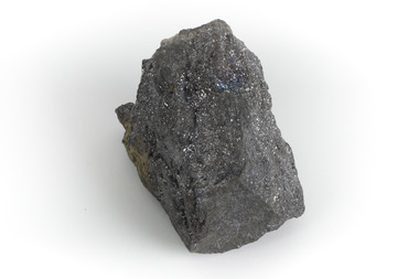 The Beechworth Burke Museum
Geological specimen - Galena Chalcopyrite, Unknown
... collected in Victoria as part of the Geological Survey of Victoria ...Galena Chalcopyrite is the earth's primary ore of lead and is mined from a large number of deposits in many countries. It is also an important source of silver. Galena Chalcopyrite is one of the most abundant and widely distributed sulfide minerals across the world. The mineral is found in igneous and metamorphic rocks in medium- to low-temperature hydrothermal veins. This specific specimen was recovered from the mines in Broken Hill, New South Wales. The mines in Broken Hill were first established after Charles Rasp discovered a large amount of silver-lead-zinc ore-body in the area in 1883. BHP (Broken Hill Proprietary) mining company was then established in 1885 and quickly became the lead in Australia's mining industry after they began excavating and exporting the country's largest amount of lead, silver, and zinc. This feat generated over $100 billion in wealth for the company.Galena Chalcopyrite is signifiant as it represents the catalyst for the rise of Australia's most influential mining companies - BHP. The mineral was one of the first to be mined in the country and after being made into lead, was used for a variety of things such as paint, batteries, ammunition, and plumbing materials before it was known to be harmful to humans. This specimen is part of a larger collection of geological and mineral specimens collected from around Australia (and some parts of the world) and donated to the Burke Museum between 1868-1880. A large percentage of these specimens were collected in Victoria as part of the Geological Survey of Victoria that begun in 1852 (in response to the Gold Rush) to study and map the geology of Victoria. Collecting geological specimens was an important part of mapping and understanding the scientific makeup of the earth. Many of these specimens were sent to research and collecting organisations across Australia, including the Burke Museum, to educate and encourage further study. A grey, solid hand-sized lead sulfide mineral with a silver metallic luster.burke museum, beechworth, geological, geological specimen, galena, galena chalcopyrite, chalcopyrite, broken hill, bhp, bhp mining, broken hill mine, mine, australia mine, lead, lead mine -
 The Beechworth Burke Museum
Geological specimen - Feldspathic Sandstone
... (in response to the Gold Rush) to study and map the geology of Victoria ...Feldspathic arenites are sandstones that contain less than 90% quartz, and more feldspar than unstable lithic fragments, and minor accessory minerals.Feldspathic sandstones are commonly immature or sub-mature.These sandstones occur in association with cratonic or stable shelf settings. Feldspathic sandstones are derived from granitic-type, primary crystalline, rocks. If the sandstone is dominantly plagioclase, then it is igneous in origin Sandstone features prominently in public buildings throughout Victoria. Most of the sandstone used as dimension stone in the State came from three sources: the Heatherlie quarry in the Grampians (Silurian), the Bacchus Marsh area (Permian), and the Barrabool Hills near Geelong (Cretaceous).Sandstone features prominently in public buildings throughout Victoria, making this specimen special as it shows the materials used by Victorian building companies. Sandstone can also be crushed, crushed stone is used in the construction of roadways and road structures such as bridges, and in buildings, both commercial and residential. This specimen is part of a larger collection of geological and mineral specimens collected from around Australia (and some parts of the world) and donated to the Burke Museum between 1868-1880. A large percentage of these specimens were collected in Victoria as part of the Geological Survey of Victoria that begun in 1852 (in response to the Gold Rush) to study and map the geology of Victoria. Collecting geological specimens was an important part of mapping and understanding the scientific makeup of the earth. Many of these specimens were sent to research and collecting organisations across Australia, including the Burke Museum, to educate and encourage further study. A feldspar-rich sandstone, a sandstone intermediate in composition between an arkosic sandstone and a quartz sandstone, containing 10% to 25% feldspar and less than 20% matrix material of clay, sericite, and chlorite. Feldspathic arenite containing less than 90 percent of the composition of quartz. Feldspar is the main composition. Feldspathic arenite may contain fragments of unstable rock, and a little amount of other minerals such as mica and heavy minerals. Some feldspathic arenite have pink or red color because of the presence of potassium feldspar or iron oxide. There are also colored light gray to white. These sandstones are usually medium to coarse grained and can contain a high percentage of granules with angular until subangular roundness. The content of the matrix can appear as the rest up to more than 15 percent, and sorting of grains can present as moderate to poorly sorted. Feldspathic sandstones are generally immature in textural maturity. Feldspathic arenite can not be judged from the structure of the sediment. Bedding can emerge from the laminate parallel to the crossbed. Fossils may appear in the layer deposited on the sea. Feldspathic arenites usually appear on the craton or the continental shelf, which can be associated with conglomerate, quartz lithic arenite, carbonate rock, or evaporites. This sandstone may also appear on the succession of sedimentary basins deposited on an unstable or deep sea, and moving arc setting. According to Pettijohn (1963) Arkose make up about 15 percent of all sandstones. Some Arkose formed in situ when the granite and related rocks disintegrate and generate granular sediments. Most of the material feldspathic sandstones derived from primary crystalline granitic rocks, such as granite or metasomatic rocks containing abundant potassium feldspar. Mineral contained in sandstones is mostly a form of plagioclase feldspar derived from quartz diorite or volcanic rock. Feldspar contained on this sandstone comes from arid to cool climates when the chemical weathering process is reduced.sandstone, natural stone, feldspathic sandstone, burke museum, geology, geological, geological specimen