Showing 532 items matching "scenic"
-
 The Beechworth Burke Museum
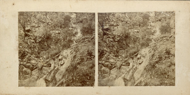
Photograph - Stereoscopic Photograph, c1900
This photograph depicts Indigo Falls, situated 20 km northeast of Beechworth, and highlights the picturesque scenery and surrounding vegetation. Known for its scenic beauty, Indigo Falls has drawn visitors from Albury and Wodonga and was a popular spot for the Beechworth Tourist Club in the early 1900s.This photograph is historically significant for showcasing the natural beauty of Indigo Falls and surrounding vegetation.Two sepia-toned square photographs featuring a rocky waterfall and vegetation, mounted.Reverse: 97.2197/ Indigo Falls/ Beechworth/ 84-116-1./ A03084/ Indigo Falls are near the start of the Indigo Valley - a short distance from the Indigo Valley Rd. turnoff is Ewarts Rd., on the right of the Beechworth Wodonga Rd., waterfall, indigo falls, ovens district, natural history, stereoscopic, district views -
 Bendigo Historical Society Inc.
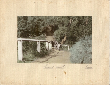
Photograph - LOVER'S WALK, COWES
coloured photo: family group ? 3 adult females in cloche hats and overcoats, two small females on scenic walk. Path through bush and trees with white post and rail fence. On front board, handwritten ' Lovers Walk, Cowes' Won by Mr. L. Batchelder ( Bendigo Photographer's family ? ) ' Gents Rope Quoits/Bay View Cowes, Feb. 1933 'A.J. Murray, Ciommercial Photographer, Photo Shop, Cosesplace -
 Bendigo Historical Society Inc.
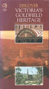
Book - Discover Victoria's Goldfield Heritage
128-page illustrated soft cover book entitled 'Discover Victoria's Goldfield Heritage. Includes Ballarat, Bendigo, Castlemaine and Stawell Written by Douglas Stone and Greg Dunnett First published 1993 by See Australia Guides Pty Ltd Printed and bound by Toppan, Hong Kong Includes route maps, city and town maps, town walks, scenic drives and bike rides.Handwritten in pen PETER RYALL on title page.goldfields, bendigo, ballarat, castlemaine, see australia guides -
 Kew Historical Society Inc
Photograph - Yarra River, Studley Park, 1924
Henry Beater Christian (1886-1962) , was a descendant of one of the earliest settler families in Kew. Employed at the Kew Asylum as a 'public servant', he was a skilled amateur photographer, photographing numerous scenes in Kew and on his travels around Victoria. The majority of his photographs date from 1916 to 1929. His finest photographs are housed in two photograph albums. Digital copy of a photograph from page 7 of the 47-page photograph album containing 261 gelatinous silver images, loaned by Diane Washfold with permission given to digitise and hold a copy in our collection. This photograph shows a covered tourist ferry moored on the river bank at Studley Park. Tourist cruises traversed the Yarra between Princess Bridge and Heidelberg, stopping at scenic points along the journey. "Studley Park / Kew"henry beater christian (1886-1962), landscape photography, kew (vic.) — yarra river, christian-washfold collection, photograph albums, kew, ferries, tourism, studley park -
 Ballarat Heritage Services
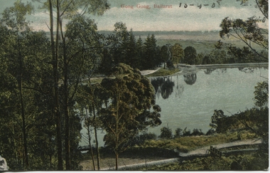
Photograph - Postcard, Gong Gong, Ballarat, 1908
Gong Gong was a locality in Ballarat East, near Fellmongers. A reservoir was built there. Situated only 10 minutes drive from the Ballarat CBD. In 2019 Gong Gong Reservoir Park is set in natural bush surrounds. There are scenics views, picnic and BBQ facilities with toilet facilities available on weekends. It is located along the Yarrowee River.photograph of Gong Gong reservoir 1908Gong Gong Ballarat - 13-4-1908 verso - note to Miss M I Wise, Gutheridge Parade, Salew. hewitt's yarrowee soap works, fellmongery, tannery, gong gong, mair street, daylesford road, o'deas, kinnane's, quin's, nestors -
 Bendigo Military Museum
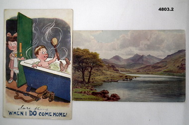
Postcard - A HUMOROUS CARD AND A SCENIC CARD, James Henderson & Sons Ltd London et al, c1910-1918
See Cat 4799 for data4803.1 - Humorous card - shows a soldier boy in a hot bath tub with a modest young girl passing some more soap on a plate. printed in colour. The title at the bottom is - "When I do come home!" "Sure thing" is hand written above the printed line. 4803.2 - Scenic Card - A coloured print showing a lane, cattle drinking and mountains in the background. Printed on the bottom is "Snowdon from Capel Curig."4803.1 - Rear has a message Mary Ling dated 25 Nov. He talks about Salisbury, Christmas leave. 4803.2 - Rear has a brief message to "Dear Susie.... (About Mail) Jo" Dated 21 Jan 1918ww!, sisters, wales, salisbury -
 Warrnambool and District Historical Society Inc.
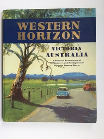
Book, Western Horizon, C 1960
This book presents a pictorial history of the western District of Victoria. It explores various aspects of the Western District such as water supply,architecture,ports,produce,and agriculture. It also presents the various scenic spots around the district. The publishers of this book , the Australian publicity Council is dedicated to publicising the state of Victoria and its natural resources in an effort to attract overseas investment and industry.This book provides a snapshot of the Western District in the 1960 's both with the information and the photographs contained within, including some which were taken by Ralph Illidge who was one on Warrnambool's best known photographers. Coloured hard board cover with country scene with road with two vehicles on a road which continues to the back cover.. A large gum tree sits beside the road. The title is gold on a navy blue banner. Thereis a small blurb on the back cover. 112 pages.Australian Publicity Council. Henry Bolte Premier of Victoria.history of warrnambool, western horizon, western victoria, ralph illidge, warrnambool 1960's -
 Victorian Interpretive Projects Inc.
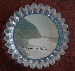
Image of souvenir ware, Apollo Bay
Apollo Bay is located between Wye River and Cape Otway on Victoria's scenic coastal route, the Great Ocean Road. In the 1840s the Henty brothers established a whaling station at Point Bunbury on the western end of the bay. The bay was named by Captain Loutit in 1845 when he sheltered his vessel, the Apollo during a storm. (http://en.wikipedia.org/wiki/Apollo_Bay)A coloured picture of a coastline attached to a glass butter plate. The coastline is Cape Patton, Apollo Bay, Victoria"Apollo Bay"apollo bay, beach, coast, souvenir -
 Clunes Museum
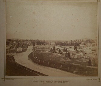
Photograph, LOOK OUT
.1 SEPIA PHOTOGRAPH MOUNTED ON BOARD, TAKEN FROM THE ROCKS (THE LOOK OUT) ON SCENIC ROAD LOOKING SOUTH. BUTTER FACTORY BRIDGE, GOVERNMENT BRIDGE OVER CRESWICK CREEK, BUTTER FACTORY BUILDING, LIGAR STREET TO THE LEFT, FRASER STREET TO THE RIGHT OF PHOTOGRAPH WITH CLUB HOTEL ETC. IN BACKGROUND - SMALL TREES IN WOODEN GUARDS ALONG CREEK. .2 SEPIA PHOTOGRAPH AS ABOVE WITH NOTES WRITTEN ON BORDER POINTING OUT PLACES OF INTERESTphotography, township and bridges, look out scenic road -
 Wodonga & District Historical Society Inc
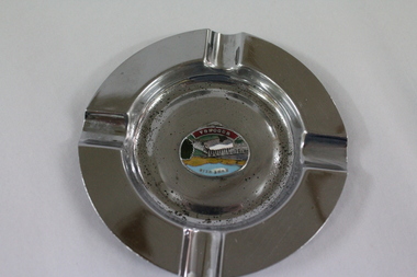
Memorabilia - Souvenir Ashtray Hume Weir Wodonga
Metal, china and glass ashtrays and other small pieces carrying scenic views of holiday destinations were a popular kind of souvenir during much of the 20th century. The pictures on the souvenirs ranged across natural beauty spots (beaches, waterfalls, rivers), civic buildings and monuments (town halls, war memorials), and indicators of local progress (commercial centres and occasionally even industrial sites).This ashtray is representative of a range of souvenirs used in the 20th century to depict Wodonga, Victoria and also on a State and National level throughout Australia.A metal circular ashtray including a coloured enamel image of the Hume Weir in the cenre."Above the central image "HUME WEIR" Beneath the central image "WODONGA"souvenir, hume weir, wodonga, ashtray -
 Wodonga & District Historical Society Inc
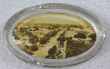
Memorabilia - Souvenir Glass Ashtray Wodonga, Victoria
A wide range of small china or glass pieces carrying scenic views of holiday destinations or key locations were a popular kind of souvenir during much of the 20th century. Several different items have been produced to commemorate Wodonga and its landmarks over time. These items document key changes in Wodonga and its heritage. This ashtray showcases a photo of High Street, Wodonga, VictoriaThis item has local historic and social significance as it depicts which features of the city the community valued in the past. It has artistic significance as an example of the kinds of souvenirs used widely across Australia to represent communities and the landscape.An oval shaped glass ashtray, incorporating a sepia print image of High Street, Wodonga, Victoriawodonga victoria, souvenir, high street wodonga, ash trays -
 Uniting Church Archives - Synod of Victoria
Photograph, Sister Gwen Lechte, Undated
SISTER Gwen, of the Methodist Home Missions Department, visited Tallygaroopna West last Wednesday, and gave a most interesting illustrated talk. As well as showing some of the scenic beauties of Gippsland, the talk and lantern slides dealt with slum conditions in South Melbourne, and showed the Methodist home at Cheltenham. Sister Gwen is a sister of Rev. E. Lechte, a former minister in the Shepparton circuit. (Shepparton Advertiser, 1 June 1943).B & W head & shoulders studio portrait of Sister Gwen Lechte, mounted on buff card.lechte, gwen, sister, methodist home missionary -
 Glenelg Shire Council Cultural Collection
Pamphlet - Pamphlets - Portland and surrounds, Victoria, n.d
Collection of pamphlets, information and maps for seven tourist tours of Portland and district. a. green Tour No. 1 Town of Portland b. pale yellow Tour No.2 Portland Harbour c. blue Tour No. 3 Scenic Drive d. gold Tour No. 4 Cobboboonee Forest e. yellow Tour No.5 Nelson, Glenelg River and caves f. pink Tour No. 6 Bridgewater Bay, Lakes, Blowholes g. orange Tour No. 7 Yambuk Lakes, Mt. ClayFront: 'VIVIAN' -handwritten, blue biro, top right -
Winchelsea and District Historical Society
Collection photos, J W (Jack) McClelland, Circ.1915
A series of photos taken in the Otways circ. 1915 showing aspects of the logging operations The actual logging operations are show including logging , transport and mill operations. Also shown are views of the forest at that time including scenic attractions. The life style of the workers is covered showing both the working and living environments. The photos were taken by J W (Jack) McCleland on glass and copies were made available to the Winchelsea Historical Society by a descendant. The collection shows the working and living environment of workers in the timber industry in the early 1900'sSeries of 70 photos from glass plates showing logging by Hendy & Sons near Mt Sabine and views of the Otways. Taken around 1915Nilotways, timber, henry, sabine mcclelland, rail, photo, -
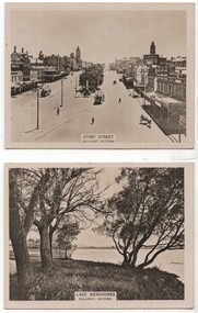 Ballarat Tramway Museum
Memorabilia - Cigarette card - Ballarat, WD HO Wills, 1920s
Cigarette cards were used as a stiffening when cigarettes were sold as separate or loose items. See reference. Sturt St - Victorian Railways photo - mid 1920s with two ESCo trams in the view. Both trams have been fitted with windscreens. The rear of the card gives details of Ballarat and is No. 43 in a series of 100 card of the Australian Scenic Series. Lake Wendouree - looking east with Mt Warrenheip in the view. No. 26 of the series, also a VR photo.Demonstrates the type of card that were made by cigarette companies as collector items and to assist their sales.Set of two WD HO Wills Cigarette photo cards using a light card.ballarat, lake wendouree, sturt street, victorian railways, cigarette cards, wd ho wills -
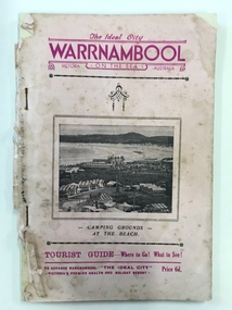 Warrnambool and District Historical Society Inc.
Booklet - The Ideal City Warrnambool On the Sea, Modern Print, 1940
This booklet has been issued in 1940 by the Warrnambool Progress and Tourist Association established in 1927. Warrnambool was the winner of the Sun News Pictorial Quest in 1928, the ‘Ideal City’ and used this title to promote the city. There had been several Tourist Associations in Warrnambool prior to 1927 and all of them promoted Warrnambool as a health resort and an ideal holiday destination with the Sea Baths in Gilles Street and the beach close by. This guide has been produced during World War Two with rationing of petrol and other goods and most people in Victoria would not have been contemplating long and expensive holidays so Warrnambool with its rail service and beach facilities would have been seen as a possible holiday destination. This Warrnambool Tourist Guide is of considerable interest both for its content regarding Warrnambool’s attractions in World War Two and for its 1940s advertisements and photographs. This is a booklet of 33 pages stapled together. It is a Warrnambool Tourist Guide from the 1940s. The pages are mostly white but there are a couple of blue and buff-coloured pages. The cover is pink with mauve and black printed material and a photograph on the front cover of the Warrnambool camping ground on the foreshore. The back cover has become detached. The booklet contains information on the tourist attractions of Warrnambool and district, black and white photographs of buildings, events and scenic spots and advertisements for local businesses. Many of the advertisements also contain photographs of business premises. Front Cover: ‘The Ideal City, Warrnambool On The Sea, , Victoria, Australia, Camping Grounds at the Beach, Tourist Guide – Where to Go! What to See! To Advance Warrnambool, The Ideal City, Victoria’s Premier Health and Holiday Resort, Price 6d.’ tourism in warrnambool, warrnambool, sun news pictorial quest, warrnambool tourist guide, the ideal city -
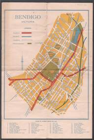 Bendigo Historical Society Inc.
Map - BILL ASHMAN COLLECTION: MAP OF BENDIGO
Map of Bendigo. Contains street of Bendigo with Places of Interest marked, Map of the Bendigo Area with Places of Interest marked, and on the centre page is Bendigo the Golden Gateway to the North. There is a map with circles around Bendigo and their distance from centre Bendigo. Circles go to a distance of 20 miles. Information includes General Information, Scenic Attractions, Industrial Activities, Industries already Established, Sporting Facilities - Bendigo and District, and Cultural Organizations. JCI shield on the left under the map. Also some brief information about Bendigo.sciences, instruments - general, scalebuoy, bill ashman collection - correspondence, map of bendigo, cambridge press, a r mcconnachie, bendigo junior chamber of commerce, bendigo city council -
 Kiewa Valley Historical Society
Photograph of Kiewa Valley Panorama, Kiewa Valley from No. 5 Road, Before 1945
In 1943 a camp for workmen was erected and a commencement made with the erection of plant storage and workshop buildings in the new township of Mt. Beauty. The photograph was probably taken after the completion of these buildings. There is no sign of construction of the town itself. In the latter part of 1945 work was commenced on the Mt. Beauty township area with a medical centre, general trading store and some houses under construction. The No. 5 Road, from where the photograph was taken, is the road to West Kiewa Power Station and Big Hill Scenic Lookout.Is an excellent view of the Kiewa Valley before there was little work undertaken to establish the town of Mt. Beauty. Farming was well established with the evidence of huge areas of cleared land. The junction of the East and West Kiewa Rivers can be clearly seen. The first Workmen's camp is near the river and some workshop buildings can also be seen. Black and white photograph of the Kiewa Valley, looking North.Handwritten on the back of photograph "Kiewa Valley from No. 5 Road".kiewa valley, camp, buildings, mt. beauty -
 Kew Historical Society Inc
Photograph - The Boulevard at Kew, 1937
The Yarra Scenic Boulevard stretching from Hawthorn to the Chandler Highway was completed as a major project between 1933 and 1936 during a period of significant unemployment. Key dates in the construction this section the road include: 1933 when Kew Council supported the construction of the road from Studley Park to the Kew Asylum; and 1936 when the road from the Johnston Street Bridge to the Chandler Highway was opened. The inscription on the reverse of the photo 'Boulevard Fairfield' is misleading as there is no section of the Boulevard in Fairfield. A more likely interpretation is that it is a photograph of the Kew section of the Yarra Boulevard with the factories of Fairfield in the distance.Rare early photograph of the Yarra Boulevard, taken one year after the opening of the road. The photograph is an important historical record of the results of 'Susso' labor in the creation of major works in Melbourne by the Victorian Government. Original, black and white positive print of the Boulevard at Kew in 1937. Key aspects to note about the photograph is that the road is bituminised; that the gutters are concreted; that the kerb is constructed of concrete blocks; and that there is an unmade footpath on what appears to be the right hand side of the road. The landscape is sparsely treed, and those trees that remain are presumably remnant vegetation. At the right, the land is fenced. The land at the left falls away sharply to the river below. On the horizon, at left, there is an industrial complex including a tall chimney that is burning fuel creating smoke. "Boulevard Fairfield" great depression, susso projects, roads -- kew (vic.), yarra boulevard, yarra valley -
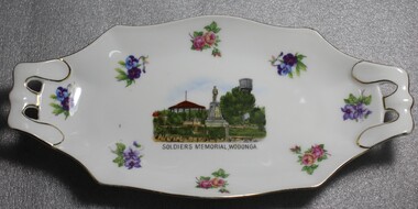 Wodonga & District Historical Society Inc
Memorabilia - Wodonga Soldiers' Memorial Plate, Victoria China, C. 1918 - 1939
A wide range of small china pieces carrying scenic views of holiday destinations or key locations were a popular kind of souvenir during much of the 20th century. Several different pieces were used to depict Wodonga during this period, primarily focusing on the Woodland Grove and the Soldier Memorial. A wide range of souvenirs have been produced to commemorate Wodonga and its landmarks over time. These items document key changes in Wodonga and its heritage. The producers mark on the plate was used by the company Victoria China Czechoslovakia between 1919 and 1938.Small china pieces carrying scenic views of holiday destinations were a popular kind of souvenir during much of the 20th century. These items have local and social significance as they reflect the landmarks or local features valued by the community over time.China Plate, Oblong in shape decorated with flowers and an image of the Soldiers' Memorial in Wodonga in the centre. Makers mark of Victoria China Czechoslovakia which was used from 1918 to1939."SOLDIERS MEMORIAL WODONGA"souvenir, soldiers memorial, wodonga victoria, victoria china, memorabilia -
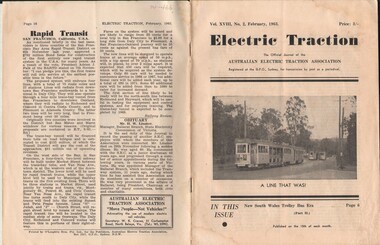 Bendigo Historical Society Inc.
Document - BASIL MILLER COLLECTION: TRAMS - JOURNAL 'ELECTRIC TRACTION', February 1963
Journal of Australian Electric Traction Association, Volume XVIII, No. 2, February, 1963, 16 pages. History of document: Part of 'Basil Miller Collection', Also check 1411. Cover picture description: "tall gum trees provide a typical Australian background to four Brisbane tram cars at Toowong Cemetery terminus. Actually cars 305, 475, 346 and 466 (left to right) are less than three miles from the Brisbane City Hall, being surrounded by parklands and a cemetery at this point along the route, which was the most scenic of the four routes recently closed on trial".Pub: Australian Electric Traction Asscn. Printer: O'Loughlin Bros. Pty. Ltd., Sydney, NSWdocument -
Clunes Museum
Weapon - NAVAL CANNON, 1847
IT IS ON PERMAMENT LOAN FROM HEPBURN SHIRE THE CANNON WAS ORIGINALLY ON THE BRITISH NAVAL SHIP "NELSON" IN FEBRUARY 1867. "NELSON" WAS HANDED OVER TO THE VICTORIAN NAVAL FORCES, ON LOAN FROM THE ROYAL NAVY. "NELSON" WAS SOLD 1898, IT IS BELIEVED THAT THE GUNS WERE THEN OFFERED FOR SALE TO COUNCILS. IT WAS DISPLAYED ON A SITE NEAR THE SCENIC ROAD, CLUNES, UNTIL THE WOODEN UNDERCARRIAGE WAS DESTROYED BY THE BUSHFIRES IN 1944. IT WAS LATER RETRIEVED AND KEPT IN THE CLUNES BOROUGH COUNCIL YARD UNTIL IT WAS RESTORED BY THE APPRENTICES AT THE BENDIGO ORDNANCE WORKSHOPS IN 1895. THE TIMBER USED FOR THE RESTORATION WAS TAKEN FROM AN ELM TREE NEAR THE CREEK IN CLUNES..1 NAVAL CANNON MOUNTED ON A WOODEN UNDERCARRIAGE. .2 CANNON BALLlocal history, military history, navy, military -
 Federation University Historical Collection
Book, Final recommendations Ballarat Study Area Land Conservation Council, Victoria, 1982, 1982
Yellow soft covered report of 95 pages . The contents of the report include: Parks, reference areas, wildlife reserves, water production, hardwood production, softwood production, flora Reserves and Flora and Fauna reserves, bushland reserves, historic area and reserves, rivers and streams, Roadside conservation and Highway parks, Education areas and School Plantations, Lake Reserves, geological reserves, recreation, scenic reserves, agriculture, mineral and stone production, utilities and survey, township land, Uncommitted Land, military training, other reserves and public land. Maps include: The Study area 1: 250 000 Supplementary Mapsland conservation authority, ballarat, endowment plantations, pine plantations, langi ghiran state park, mount buangor state park, enfield state park, ballarat-creswick regional park, rossbridge, black lake, flax mill swamp, dereel lagoon, lake bolac, lake wongan, langi ghiran reservoir, gong gong reservoir, pincotts reservoir, beales reservoir, wilsons reservoir, moorabool reservoir, korweinguboora, korweinguborra reservoir, learmonth bores, sago hill, illabarook reservoir, ballarat water commission, dunneworthy, mount cole, mont lonarch, ben major, waterloo, trawalla, linton, ross creek, canadian, shepherds flat, lal lal, mount doran, raglan, chute, carngham, buninyong, watsons hill, enfield, cape clear, illabrook, rokewood junction, mount warrenheip, nerrina, jubilee, golden stream, australasian deep lead mine, happy valley school, piggoreet, berringa, bulldog, ballarat common, wildlife, water, timber, flora, rivers, geology, agriculture, warrenheip, biodiversity -
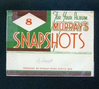 Orbost & District Historical Society
photographs, Murray Studio, Murray Views, 1940's 1950's
This collection of photographs produced by Murray Views, Gympie, features eight scenic black / white photographic prints of Orbost and surrounding tourist areas.Photographs like these allowed tourists to send many images of their holiday destination or hometown in the one small package. Fred Murray opened Murray Studios in Gympie in 1906. The postcard and souvenir production side of the business initially covered Gympie and surrounding regions, but Murray expanded the business to include North Queensland, NSW and even Adelaide. It was opened under a separate name, Murray Views, in 1929. In 1945 the business was taken over by Murray’s nephews who began postcard folder production.These photographs are a useful research material.A white envelope with green and white print containing eight photographs of the Orbost area. It is titled For Your Album Murray's Snapshotssouvenir photographs-orbost postcards -
 Otway Districts Historical Society
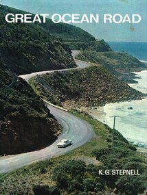
Book, Rigby Limited, Great Ocean Road. K.G. Stepnell, 1972
The Great Ocean Road may be the only road in the world which was built as a war memorial. In 1916, much of Australia was poorly served by roads, and it was suggested that returning servicemen could be given worthwhile employment by building roads in isolated areas. The plan was taken up for the Great Ocean Road, and work was dedicated to the memory of men who had fallen in World War 1. The road itself is a great feat of engineering. It wind around some of Australia's most rugged coastline. Now it is one of the world's most scenic routes, crossing gorges, along precipitous cliffs, through dense forests, and over steeply rolling coastline country.Great Ocean Road. K.G. Stepnell. 1st ed. Rigby Limited; Adelaide (S.A.); 1972. 36 p.; illus., maps. Hard cover. ISBN 0 85179 371 1great ocean road; roads; fishing; timber; twelve apostles; -
 Eltham District Historical Society Inc
Photograph - Aerial Photograph, Landata, Eltham, Vic, Jan. 1951
Centred on Allison Crecent Reserve, Sherbrook Road and Scenic Crescent, Eltham bounded by Allendale Road to north, Dudley Street to south, Zig Zag Road to east and St Helena Road to west. Historic Aerial Imagery Source: Landata.vic.gov.au Aerial Photo Details: Project No :65 Project : MELBOURNE AND METROPOLITAN PROJECT NO. 2 Run : 7 Frame : 10 Date : 01/1951 Film Type : B/W Camera : EAG9 Flying Height : 12200 Scale : 12000 Film Number : 1419 GDA2020 : 37°42'14"S, 145°08'36"E MGA2020 : 336339, 5825416 (55) Melways : 21 H2 (ed. 42)Historical aerial photos and photo maps provide viusal evidence of the chronology of changes to the built landscape of the district and assist in dating other imagesaerial photo, 1951-01, eltham, neil webster collection, allendale road, allison crecent reserve, dudley street, melway 21h2, scenic crescent, sherbrook road, st helena road, zig zag road -
 Bendigo Historical Society Inc.
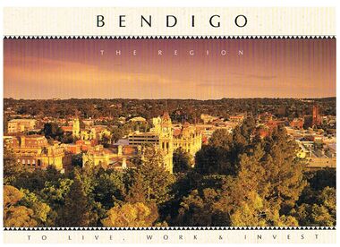
Book - BENDIGO - THE REGION TO LIVE, WORK & INVEST
Pale yellow 12 page book titled 'Bendigo the Region to Live Work & Invest'. On the front cover is a scenic view of Bendigo and on the back cover a picture of some quartz and gold nuggets on a green background. Sections in the book are: Live Work & Invest, Lifestyle, Access, Community, Infrastructure, Labour Force, Business, Opportunity, Successes and Information. Each page has a colour picture, they are:- Hargreaves Mall, Eaglehawk Golf Course, Map of Victoria, La Trobe University, Big Hill, Regional Office Department of Planning & Development, Sandhurst Farms, Construction Activity, Products of the Region, Dr. Ian Macbean, Mr Evan Jones and the Capital Theatre with information on each.book, bendigo, bendigo, bendigo - the region to live, work & invest, bendigo regional development board, dr ian macbean, mr evan jones, kate mildren, richard gibbs, express printers, hargreaves mall, eaglehawk golf course, map of victoria, la trobe university, big hill, regional office department of planning & development, sandhurst farms, construction activity, products of the region, capital theatre -
 Parks Victoria - Mount Buffalo Chalet
Honour Board
Was located in the stables at Mount Buffalo Chalet. It was used to record the names of horses that were ridden by Chalet guests when they were holidaying at the Chalet. 'Admiring the rugged beauty of the Buffalo Plateau and exploring its scenic attractions ...quickly became part of the Mount Buffalo Chalet tourist experience...The Chalet facilitated the experience by hosting guided tours, including trail rides on horseback...the horses remained at the Chalet for decades, and have been remembered with great affection, as demonstrated by the honour roll for Chalet horses and various commemorative plaques.' (Pg 98. Historica) Many of these horses are still remmbered by former guest of the Chalet. Granite and Punka were legendary and plaques in their honor are mounted on the large granite boulders in the stableyards.Listed in Draft Inventory of Significant Collection items. Appendix A.3, Snow sports equipment and other recreational items. (Pg 166 Historica).Wooden plaque with names painted onto strips of leather fixed to a board. The board is made of two sections of wood and is arched at the top and squared at the base. The piece at the top that appears to be earlier and has gold painted inscriptions with decorative scrolling around the edge. The board has leather strapping around the edge and two stirrups threaded onto leather at the base. The upper section of the board has all the names painted onto leather strips. The lower section of the board has some names painted onto strips but also some names are scratched directly onto the wood.At top of plaque, "ROLL OF HONOUR /TO / OUR FRIENDS - / THE CHALET HORSES, / WHO GAVE US MANY HAPPY HOURS / BUT WHO HAVE SINCE MOVED / "DOWN THE HILL". FROM THE / TIME OF "PUNKA" / WHO SERVED / FAITHFULLY FOR 20 YEARS" Underneat this are the names of the individual horses starting with , "PUNKA....." -
 Ballarat Tramway Museum
Postcard, Sturt St. in the mid 1940's
Printed colour postcard of photograph of Sturt St. in the mid 1940's looking from the top of a building in Grenville St. towards the West. Has a number of parked vehicles in kerbs, two people riding horses, a Vacuum Oil Co. truck in the bottom right hand corner and an SEC tram travelling west, just past the City Loop points. See Reg Item 675 for the same photograph - slightly cropped. Victorian Railways photograph. On rear the card has been ruled for address, stamp and titled postcard. Along the bottom edge is the publication details "ANSCOL - Australian Natural Scenic Colour - Thomas Tennant, 14 Jaques St., Chatswood N.S.W." trams, tramways, sturt st, postcards, sec, grenville st, tram 4 -
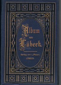 Bendigo Historical Society Inc.
Book - GERMAN HERITAGE SOCIETY COLLECTION: ALBUM VON LUBECK
Item 3. Blue cardboard album with long fold out pages holding 12 photos. The photos are scenic or of buildings of Lubeck. The front cover has a gold and black pattern and the name is imprinted in gold. The photos are numbered. The photos are: 1. Overlooking Lubeck, 2. Lubeck from the Cathedral Tower, 3, Lubeck Harbour, 4. Market Square, Lubeck, 5. Holsten Gates: St Mary's Church; St Peter's Church, 6. Holy Ghost Hospital, Lubeck, 7. Cathedral, Lubeck, 8. Broad Street and Town Hall, Lubeck, 9. Burg Gates, Lubeck, 10. Holsten Gates, Lubeck, 11. St Jacob's Church, Lubeck, 12. Interior of St Mary's Church, Lubeck.L Petersbooks, collections, buildings of lubeck, german heritage society collection - album von lubeck, l peters