Showing 2272 items
matching services centres
-
 Warrnambool and District Historical Society Inc.
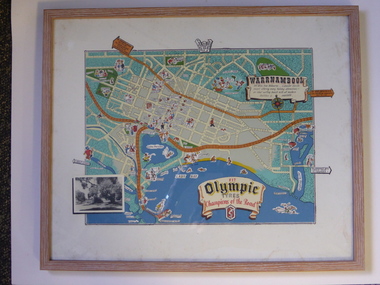
Advertising, Tourist Map of Warrnambool (framed x 2), 1950s
These framed tourist maps came from the Lane Foundation so it is presumed that they were from the office of Lane’s Travel Service which operated from 205 Raglan Parade Warrnambool with the known dates, the 1950s and 1960s. The proprietor, Alan Lane, was a successful Warrnambool businessman who operated a Warrnambool and district bus service as well as his travel business. He was heavily involved in local community affairs being a Warrnambool Councillor for 18 years from 1952 to 1970 and President of the Warrnambool Chamber of Commerce for six years. He was a major donor to the Warrnambool Performing Arts Centre, the Warrnambool Art Gallery and the St. John of God Hospital and left the bulk of his estate to the Alan Lane Foundation which has contributed millions of dollars to local organizations and programs. Alan Lane died in 1995. These framed maps are of some interest as examples of the tourism maps used to promote the city and district in the 1950s and 60s. This is a tourist map of the Warrnambool C.B.D. and adjoining streets produced as an advertisement for Olympic Tyres. It is multi-coloured and has cartoon sketches of the main tourist attractions and pointers to attractions outside of the main city area. It includes an inset black and white photograph of the Warrnambool Botanic Gardens and an advertisement for Olympic Tyres. It is printed on a white background and is enclosed behind glass in a wooden frame of a light brown colour. It has a wire at the back for attachment to a wall. ‘Warrnambool – 163 miles from Melbourne – a popular tourist resort offering many holiday attractions – an ideal surfing beach with all modern facilities is avalable’ ‘Fit Olympic Tyres, Champions of the Road’ alan lane foundation, warrnambool tourism -
 Warrnambool and District Historical Society Inc.
Plate, Dinner Plate, Early 19th century
The only information available on this plate is what is written on the base. No other information has been found on Mrs Playford or Thomas and Mary Annerley. Perhaps the plate came to into the collection of the Warrnambool and District Historical Society via the old Warrnambool Museum. The plate has no known local provenance and is kept because of its age and interesting monogram. This is a circular-shaped china plate (probably a dinner plate) with a fluted edge. The edging of the plate has red and gold ornamentation with garlands of flowers in green, pink, mauve and orange. There are four posies of flowers around the bowl of the plate in the same colouring with the addition of blue. In the centre of the plate is a large gold monogram – ‘T.M.A.’ On the base of the plate is a piece of paper partly torn off giving some details of the history of the plate in handwriting. This paper is pasted on to the base of the plate obscuring any maker’s mark that there may be. The plate has been broken into four pieces and stuck together again using five metal clips. There are some chips around the edge of the plate. Monogram: ‘T.M.A.’ ) (Thomas and Mary Annerley) Note on base: ‘… … the property of Mrs Playford of … St. Brighton (and formerly belonged to her great grandmother). Mrs Playford died in her 91st year and left it with some other pieces of the service to William Rodgers of Wellington St., St. Kilda. Monogram, T.M.A, Thomas & Mary Annerley. Copy of signed statement, 1909’ mrs playford, thomas and mary annerley -
 Kiewa Valley Historical Society
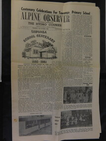
Alpine Observer Newspaper - 23 Oct. 1980 x2, 23 Oct. 1980
The Tawonga Primary School celebrated its centenary with a program including a fete, sports, family dance and combined church service over the weekend of the 25th - 26th Oct. 1980. The newspaper covers the Alpine Shire and included further articles that would interest visitors to the centenary.Tawonga School was one of the earliest schools in the Kiewa Valley supplying an education for the children of the local farming community. The Bogong Hotel at Tawonga, the Tawonga Butter Factory and the town of Mt Beauty articles were printed providing up to date historical information on prime locations nearby. Of interest as the Hotel has burnt down and the Butter factory no longer exists. Alpine Observer newspaper dated Thursday, 23 rd October 1980 with a sketch of the school and articles regarding the Centenary of the Tawonga School on the front page. (The paper consists of 12 pages ie. 6 sheets) 2 copies On page 4 is an article on the history of the Bogong Hotel at Tawonga On page 5 is an article on the history of the Tawonga Butter Factory and an article on the township of Mt Beauty.newspaper articles; tawonga primary school; bogong hotel; tawonga butter factory -
 Kiewa Valley Historical Society
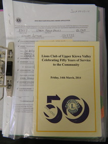
Folder - Upper Kiewa Valley Lions Club 2010 - 2015 & Booklet, Lions Club of Upper Kiewa Valley Celebrating Fifty Years of Service to the Community, 2010 - 2015
The Upper Kiewa Valley Lions Club was established in March 1964 and celebrated 50 years in 2014.Residents of the Kiewa Valley belonged to the Upper Kiewa Valley Lions Club. They are/were involved in many community activities and services eg. The Take Away shop at Falls Creek, Christmas carols, the conquestathon Purple folder with Upper Kiewa Valley Lions Club with correspondence and summary forms covering 1010 - 1015. Includes members names. Booklet is yellow with black heading and '50' with green Lions insignia inside the O.lions club; upper kiewa valley; 50th anniversary; community service -
 Kiewa Valley Historical Society
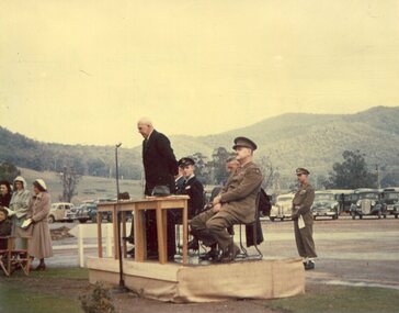
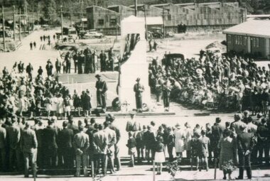
Photo - Anzac Day Mt Beauty 1950, 25/04/1950
Anzac Day commemoration at Mt Beauty in 1950Commemoration of war service by residents of Mt Beauty and surrounding towns. H.H.C. Williams, Chief Engineer of the Kiewa Hydro Electric Scheme, giving the address at the Anzac Day Service.Colour photograph of Anzac Day commemorations in Mt Beauty in 1950mt beauty, anzac day -
 Kiewa Valley Historical Society
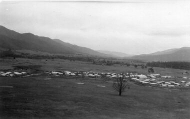
Photographs x 2 - 1. Mt Beauty Camp 2. Bogong Camp, Photo 1 - September 1950
Mt Beauty Camp- The new State Electricity Commission construction camp at the head of the Kiewa Valley was for workmen on the second power station in the project expected to be the most modern and best equipped in Australia… In contrast to the early Kiewa days of horses and canvas tents, the new camp, with its modern amenities, compared favourably with any country town. Administration of the Kiewa Scheme was moved from Tawonga to Mount Beauty in 1946. The first house in Mount Beauty, in Hollonds Street, was occupied by the co-op store manager from November 1946. The new Mess Hall at Mt Beauty was opened with much ceremony in early November 1946. The houses up to Nelse street were erected from 1946 onward and then the township was extended beyond Nelse Street in 1950. The workmen's camp was enlarged in 1950 to the extent of providing accommodation for a total of 1,200. Bogong Camp - In 1940 Field Headquarters for the Kiewa Scheme were established at Bogong with office, workshop facilities and accommodation for workmen, staff and some families constructed. (There had been a 'tent camp' on this site in 1939 but was destroyed by bushfires) Construction of accommodation continued until 1947. A total of 40 houses plus a hostel for single staff, post office, police station, medical centre and primary school all with water and sewerage and electricity supply. The staff hostel was known as Kiewa House and is now occupied by the Education Department. Lake Guy was named after Mr. L.T. Guy who was the Resident Engineer in charge of construction work and associated activities on the Kiewa area. He held this position from 1939 to November 1946 when he was transferred to Head Office. Both Bogong Village and Mt Beauty were developed to accommodate workmen on the Kiewa Hydro Electric Scheme but have since become centres for tourism and a range of outdoor activities.1. Black and white photograph of Mount Beauty Camp taken in September 1950 2. Black and white photograph of Bogong Village Camp1. Written on the back in grey lead - Sept 1950. Mt Beauty Camp. HT Cooper own taking 2. Stamped on back of photograph - Copyright. Not for reproduction. Herald Sun feature Service. Melbourne Australiamt beauty camp, bogong camp, secv -
 Kiewa Valley Historical Society
Photograph - Anzac Day Mt Beauty (Before 1966), Pre 1966
Anzac Day in Mt Beauty before 1966. Background- SEC workshops with saw tooth roof. Taken in the days before the service station was built on the corner.Record of community of Mt Beauty and surrounds commemorating the involvement of their community members in military service and remembering those who gave their lives in war.Black and white photograph of Anzac Day commemorations in Mt Beauty - pre 1966. Photo looking down the highway towards Tawongamt beauty, anzac day -
 Kiewa Valley Historical Society
Photographs – Kiewa Cres Mt Beauty. Circa 1993. Set of 12 colour photographs
Established in 1946, during the construction of the Kiewa Hydro Electric Scheme, the township of Mt Beauty was developed by the State Electricity Commission of Victoria to provide additional accommodation for the thousands of workers during the construction of the country’s second largest hydro-electricity scheme. Although these towns were built as temporary accommodation for the workers and their families, many stayed after the scheme finished. Combined with the influx of European migrants, with their rich cultural backgrounds, all played a major part in shaping the future character of the Mount Beauty, the Kiewa Valley and Falls Creek. The Bright Council, now the Alpine Shire took over the control of the township in 1960. This relatively young town of Mount Beauty, along with the surrounding townships of Falls Creek, Bogong, Tawonga South and Tawonga, are all part of a prospering tourist area with excellent services, accommodation, food and a wide range of recreational activities available for all ages. According to Shire records, the population of Mt Beauty has grown from 1,500 in 1981 to 1,800 in 2016 with a projected increase to 2,000 in 2013The photographs taken around 1993 show a prosperous commercial centre catering for both locals and the needs of visitors. It provides a pictorial history of the changes which have occurred in the retail/commercial district of Mt Beauty over the years. It also demonstrates the attention paid by Alpine Shire towards providing accessible recreational green space around the town centre.Set of 12 colour photographs of Kiewa Cres Mt Beauty. Circa 1993 showing retail services and streetscape of the time. No markingskiewa cres mt beauty, mt beauty -
 Kiewa Valley Historical Society
Photographs – Lakeside Avenue, Mt Beauty. Circa 1993. Set of 7 colour photographs
Established in 1946, during the construction of the Kiewa Hydro Electric Scheme, the township of Mt Beauty was developed by the State Electricity Commission of Victoria to provide additional accommodation for the thousands of workers during the construction of the country’s second largest hydro-electricity scheme. Although these towns were built as temporary accommodation for the workers and their families, many stayed after the scheme finished. Combined with the influx of European migrants, with their rich cultural backgrounds, all played a major part in shaping the future character of the Mount Beauty, the Kiewa Valley and Falls Creek. The Bright Council, now the Alpine Shire took over the control of the township in 1960. This relatively young town of Mount Beauty, along with the surrounding townships of Falls Creek, Bogong, Tawonga South and Tawonga, are all part of a prospering tourist area with excellent services, accommodation, food and a wide range of recreational activities available for all ages. According to Shire records, the population of Mt Beauty has grown from 1,500 in 1981 to 1,800 in 2016 with a projected increase to 2,000 in 2013The photographs taken around 1993 show a prosperous commercial centre catering for both locals and the needs of visitors. It provides a pictorial history of the changes which have occurred in the retail/commercial district of Mt Beauty over the years. It also demonstrates the attention paid by Alpine Shire towards providing accessible recreational green space around the town centre.Set of 7 colour photographs of Lakeside Avenue, Mt Beauty. Circa 1993 showing retail services and streetscape of the time. No markingsmt beauty, lakeside ave mt beauty -
 Kiewa Valley Historical Society
Photographs – Tawonga Cres., Mt Beauty. Circa 1993. Set of 4 colour photographs
Established in 1946, during the construction of the Kiewa Hydro Electric Scheme, the township of Mt Beauty was developed by the State Electricity Commission of Victoria to provide additional accommodation for the thousands of workers during the construction of the country’s second largest hydro-electricity scheme. Although these towns were built as temporary accommodation for the workers and their families, many stayed after the scheme finished. Combined with the influx of European migrants, with their rich cultural backgrounds, all played a major part in shaping the future character of the Mount Beauty, the Kiewa Valley and Falls Creek. The Bright Council, now the Alpine Shire took over the control of the township in 1960. This relatively young town of Mount Beauty, along with the surrounding townships of Falls Creek, Bogong, Tawonga South and Tawonga, are all part of a prospering tourist area with excellent services, accommodation, food and a wide range of recreational activities available for all ages. According to Shire records, the population of Mt Beauty has grown from 1,500 in 1981 to 1,800 in 2016 with a projected increase to 2,000 in 2013The photographs taken around 1993 show a prosperous commercial centre catering for both locals and the needs of visitors. It provides a pictorial history of the changes which have occurred in the retail/commercial district of Mt Beauty over the years. It also demonstrates the attention paid by Alpine Shire towards providing accessible recreational green space around the town centre.Set of 4 colour photographs Tawonga Crescent, Mt Beauty. Circa 1993 showing retail services and streetscape of the time No markingstawonga cres mt beauty -
 Kiewa Valley Historical Society
Photographs – Holland Street North, Mt Beauty. Circa 1993. Set of 18 colour photographs
Established in 1946, during the construction of the Kiewa Hydro Electric Scheme, the township of Mt Beauty was developed by the State Electricity Commission of Victoria to provide additional accommodation for the thousands of workers during the construction of the country’s second largest hydro-electricity scheme. Although these towns were built as temporary accommodation for the workers and their families, many stayed after the scheme finished. Combined with the influx of European migrants, with their rich cultural backgrounds, all played a major part in shaping the future character of the Mount Beauty, the Kiewa Valley and Falls Creek. The Bright Council, now the Alpine Shire took over the control of the township in 1960. This relatively young town of Mount Beauty, along with the surrounding townships of Falls Creek, Bogong, Tawonga South and Tawonga, are all part of a prospering tourist area with excellent services, accommodation, food and a wide range of recreational activities available for all ages. According to Shire records, the population of Mt Beauty has grown from 1,500 in 1981 to 1,800 in 2016 with a projected increase to 2,000 in 2013The photographs taken around 1993 show a prosperous commercial centre catering for both locals and the needs of visitors. It provides a pictorial history of the changes which have occurred in the retail/commercial district of Mt Beauty over the years. It also demonstrates the attention paid by Alpine Shire towards providing accessible recreational green space around the town centre.Set of 18 colour photographs Holland Street North, Mt Beauty. Circa 1993 showing retail services and streetscape of the time. No markingsholland st mt beauty, mt beauty -
 Kiewa Valley Historical Society
Photographs – Holland Street South, Mt Beauty. Circa 1993. Set of 16 colour photographs
Established in 1946, during the construction of the Kiewa Hydro Electric Scheme, the township of Mt Beauty was developed by the State Electricity Commission of Victoria to provide additional accommodation for the thousands of workers during the construction of the country’s second largest hydro-electricity scheme. Although these towns were built as temporary accommodation for the workers and their families, many stayed after the scheme finished. Combined with the influx of European migrants, with their rich cultural backgrounds, all played a major part in shaping the future character of the Mount Beauty, the Kiewa Valley and Falls Creek. The Bright Council, now the Alpine Shire took over the control of the township in 1960. This relatively young town of Mount Beauty, along with the surrounding townships of Falls Creek, Bogong, Tawonga South and Tawonga, are all part of a prospering tourist area with excellent services, accommodation, food and a wide range of recreational activities available for all ages. According to Shire records, the population of Mt Beauty has grown from 1,500 in 1981 to 1,800 in 2016 with a projected increase to 2,000 in 2013The photographs taken around 1993 show a prosperous commercial centre catering for both locals and the needs of visitors. It provides a pictorial history of the changes which have occurred in the retail/commercial district of Mt Beauty over the years. It also demonstrates the attention paid by Alpine Shire towards providing accessible recreational green space around the town centre.Set of 16 colour photographs Holland Street South, Mt Beauty. Circa 1993 showing retail services and streetscape of the time. No markingsholland st mt beauty, mt beauty -
 Kiewa Valley Historical Society
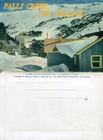
Souvenir Postcard Folder – Falls Creek Ski Village
After World War II, the Kiewa Hydroelectric Scheme was started in the Kiewa River valley by the State Electricity Commission of Victoria. On land previously used only for summer cattle grazing in the natural alpine grasslands, the first ski lodge was built in 1948 by workers from the scheme. The first lift, a rope tow, was built in 1951 and the first chairlift in Australia was constructed there in 1957. Falls Creek Post Office opened on 9 June 1958 (with telegraph and telephone facilities only until 1964) .Despite strong opposition from the head of the Kiewa scheme, who didn't want tourists clogging up his roads and destroying his "dry" construction camps by bringing in booze, Falls Creek boomed as much as Hotham, partly owing to its relatively good access road. Early lodges included Bogong (c.1946), Skyline (1947), Albury (1949), Myrtleford (1949) and Dawn (c.1950).The souvenir postcard photographed and produced by an enterprising local businessman Mr S K Pearce, was produced as a memento for skiers and other visitors to the Falls Creek and Mt Beauty area to send to family and friends as a reminder of their visit to the region, or to keep as a personal souvenir. It presented an excellent promotional opportunity for enterprising local businessmen to promote the area to skiers and tourists near and far. It also presents an excellent pictorial history of the falls creek area around the late 1950’s to early 1960’sColour postcard folder (unused) containing 13 photographs of the Falls Creek ski area and surrounds. Inside cover has a brief description of the area and the services available to visitors Printed on front cover- FALLS CREEK SKI VILLAGE. Your Souvenir Folder Photo of skiing slopes of the village Inside front flap - a brief description of the Falls Creek area and the services available to visitors 1. Diana Lodge parking area and Spion Kopje 2. Winterhaven Lodge 3. Ski Hirage Centre and skiing slopes 4. Ski Lodges from main road 5. Nelse and Arundel Lodges 6. Day visitors’ shelter and parking area 7. Summit T-Bar lift 8. Spur T-bar looking towards Village and Spion Kopje 9. T-bar lower station and Snow Crystal Inn 10. ‘Akja’ rescue sled in use 11. Falls Creek road and Grand Coeur Lodge annex 12. Rope tows and beginner slopes 13. Back cover- Published by Nucolorvue Pty Ltd Mentone Vic. Printed in Australia For S.K.Pearce Pty Ltd Tawonga and Mt Beauty falls creek, snow, bogong high plains, victorian alps -
 Kiewa Valley Historical Society
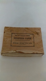
Photographs of small box originally used to contain sensitized photographic paper
The Junction Dam and Clover Dam Power Station, stages of the Kiewa Hydro-Electric Scheme, were needed to meet the increased power demands of the wartime industry in Victoria. Clover added 26 megawatts to the grid. Junction Dam was completed and ready to hold water by September 1943, but was emptied in December 1943 and not filled again until May 1944. Construction of Clover Power Station commenced in July 1941 and both turbines were in service by May 1945.Clover Power Station and Junction Dam were part of the Kiewa Hydro Electric Scheme constructed by the State Electricity Commission of Victoria. SECV official photographers took photographs of most stages of construction of the Hydro Electric Scheme and referenced each photo with a number and dating system as an historical record and for reference for other projects. This provided a thorough history of the construction of the Hydro Electric Scheme, some of the workers involved in its construction and the infrastructure supporting its construction, such a Bogong Village.Small light brown cardboard box originally containing sensitized photographic paper, now containing a range of black and white photographs of the Kiewa Hydro Electric System taken by the official SECV photographer Box has some damage – Front panel on lid is missing. Top has a puncture in top right corner and some peeling of paper along sides and at edges. Printed on the top of the box in black ink: OPEN ONLY IN PHOTOGRAPHIC DARK ROOM SENSITIZED PAPER Manufactured by – KODAK (A/asia) PTY. LTD. Melbourne Australia Green and white sticker on right side of lid and bottom right side of box, torn at join 1. 1B1 Single Weight Soft. Available in Soft (1) Medium (2) Contrast (3) Extra Contrast (4) Single and Double Weight Stamped at bottom of sticker in grey ink G8087 CK photographic paper box; state electricity commission of victoria; official photographer; kiewa hydro electric scheme; clover power station; junction dam; bogong village -
 Kiewa Valley Historical Society
Photographs – SECV – Clover Power Station
The Junction Dam and Clover Dam Power Station, stages of the Kiewa Hydro-Electric Scheme, were needed to meet the increased power demands of the wartime industry in Victoria. Clover added 26 megawatts to the grid. Junction Dam was completed and ready to hold water by September 1943, but was emptied in December 1943 and not filled again until May 1944. Construction of Clover Power Station commenced in July 1941 and both turbines were in service by May 1945.Clover Power Station and Junction Dam were part of the Kiewa Hydro Electric Scheme constructed by the State Electricity Commission of Victoria.Set of 22 black and white photographs taken by the official SECV photographer who gave each photo a number prefixed by K (for Kiewa) K60 -no date- A bridge and entrance to tunnel K519 -no date- Welding steel lining in the tunnel K531 –no date- Construction on the Kiewa Scheme (tunnel in background K821 – no date- Bogong Village, early days K928 -15 Oct 1942- Construction Clover Power Station K947 -26 Oct 1942- Construction Clover Power Station K948 -26 Oct 1942- Construction Clover Power Station K949- 26 Oct 1942- Clover Camp in background K950 -26 Oct 1942- Construction Clover Power Station K955 -27 Oct 1942- Constructing the bridge at Clover K1102 -7 April 1943- Inlet pipe to power station K1179 –no date- Clover Power Station K1187 – no date- Clover Power Station K1189 -24 June 1943- Part of the spiral casing 1199 -7 July 1943- Clover Power Station K1201 -7 July 1943- Clover Power Station K1231 -26 July 1943- Gantry crane for Clover Power Station K1308 -6 Sept 1943- Spiral casing K1334 -6 Oct 1943- Lake Guy. Bogong Village in background K1342 -29 Oct 1943- Power station under construction K1365 -19 Nov 1943- Power station under construction K1366 -19 Nov 1943- Gantry crane for Clover Power Station On the back- each photograph has a handwritten reference number starting with K and the date stamped or written (see above)secv; kiewa hydro electric scheme; official photographer; junction dam; clover power station; bogong; -
 Kiewa Valley Historical Society
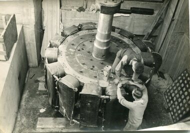
Photographs – SECV – Clover Power Station
The Junction Dam and Clover Dam Power Station, stages of the Kiewa Hydro-Electric Scheme, were needed to meet the increased power demands of the wartime industry in Victoria. Clover added 26 megawatts to the grid. Junction Dam was completed and ready to hold water by September 1943, but was emptied in December 1943 and not filled again until May 1944. Construction of Clover Power Station commenced in July 1941 and both turbines were in service by May 1945.Clover Power Station and Junction Dam were part of the Kiewa Hydro Electric Scheme constructed by the State Electricity Commission of Victoria.Set of 21 black and white photographs taken by the official SECV photographer who gave each photo a number prefixed by K (for Kiewa) K1367- 19 Nov 1943 The rotor for the generator K1368- 19 Nov 1943 Base of the generator K1377- 2 Dec 1943 Generator under construction K1380- 2 Dec 1943 Power Station under construction K1381- 2 Dec 1943 Generator being assembled K1386- 3 Dec 1943 Part of the generator K1389- 30 Dec 1943 Inlet pipe work K1391- 30 Dec 1943 Inside the power station K1392- 30 Dec 1943 Inlet pipe work K1396- 27 Jan 1944 Equipment in the power station K1410- 4 FGeb 1944 Unpacking equipment for the power station K1422- 16 Feb 1944 Generator being assembled K1425- 22 Feb 1944 Water way – power station K1433- no date Generator being assembled K1434- 3 Mar 1944 Constr5ucting the power station K1448- no date Generator inside the power station K1450- 17 Mar 1944 Clover Power station K1452- 17 Mar 1944 Looking down on the valve-water release from the power station K1456- 22 Mar 1944 ‘half Travel Opening- No 1 Relief Valve’ Overflow from the power station K1458- 22 Mar 1944 Outlet from the power station K1462- 22 Mar 1944 Inside the power station On the back- each photograph has a handwritten reference number starting with K and the date stamped or writtensecv; kiewa hydro electric scheme; clover power station; junction dam; bogong -
 Kiewa Valley Historical Society
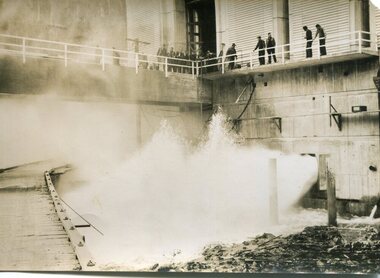
Photographs – SECV – Clover Power Station
The Junction Dam and Clover Dam Power Station, stages of the Kiewa Hydro-Electric Scheme, were needed to meet the increased power demands of the wartime industry in Victoria. Clover added 26 megawatts to the grid. Junction Dam was completed and ready to hold water by September 1943, but was emptied in December 1943 and not filled again until May 1944. Construction of Clover Power Station commenced in July 1941 and both turbines were in service by May 1945Clover Power Station and Junction Dam were part of the Kiewa Hydro Electric Scheme constructed by the State Electricity Commission of VictoriaSet of 21 black and white photographs taken by the official SECV photographer who gave each photo a number prefixed by K (for Kiewa) K1463- 22 Mar 1944 Inside Clover Power Station K1464- 23 Mar 1944 Valve K1466- 23 Mar 1944 Fittings for the power station K1467- 23 Mar 1944 Valve K1472- 30 Mar 1944 Equipment being installed in Clover Power Station K1474- 31 Mar 1944 Equipment for the power station K1493- 19 April 1944 Transformer K1495- 28 April 1944 Part of the generator being installed K1514- 11 May 1944 Equipment in the power station K1563- 9 June 1944 Turbine under construction K1565- 22 June 1944 Shaft between turbine and generator K1567- 22 June 1944 Turbine in the power station K1568- 22 June 1944 Transformers K1570- 5 June 1944 Guide vane actuators K1574- 22 June 1944 Equipment in the power station K1567- 22 June 1944 Clover Power Station K1607- 14 Aug 1944 Equipment in the power station K1620- 27 Aug 1944 ‘Charles Tavare (?) Equipment in the power station K1626- 23 Aug 1944 Clover Power Station K1628- 23 Aug 1944 Clover Power Station K1629- 23 Aug 1944 Clover Power Station On the back- each photograph has a handwritten reference number starting with K and the date stamped or writtensecv; kiewa hydro electric scheme; clover power station; junction dam; bogong -
 Kiewa Valley Historical Society
Photographs – SECV – Clover Power Station
The Junction Dam and Clover Dam Power Station, stages of the Kiewa Hydro-Electric Scheme, were needed to meet the increased power demands of the wartime industry in Victoria. Clover added 26 megawatts to the grid. Junction Dam was completed and ready to hold water by September 1943, but was emptied in December 1943 and not filled again until May 1944. Construction of Clover Power Station commenced in July 1941 and both turbines were in service by May 1945.Clover Power Station and Junction Dam were part of the Kiewa Hydro Electric Scheme constructed by the State Electricity Commission of VictoriaSet of black and white photographs taken by the official SECV photographer who gave each photo a number prefixed by K (for Kiewa) K1630- 23 Aug 1944 Clover Power Station K1633- no date Clover Power Station K1683- 10 Oct 1944 Weir K1700- no date Tail boy for Clover Power Station K1710- 11 Oct 1944 Part of aqueduct – Clover K1767- 6 Jan 1945 Switchboard in the power station K1769- 6 Jan 1945 Turbine and shaft K1770- 10 Jan 1945 Houses under construction at Bogong Village K1897- 22 Feb 1945 Equipment in the power station K1808- 22 Feb 1945 Equipment in the power station K1910- 31 May 1945 Top of the turbine and the shaft K1964- 16 Jul 1945 Equipment in the power station K1970- 17 Jul 1945 Bogong Village K1983- 30 Jul 1945 Turbine in power station K1984- 30 Jul 1945 Bogong Village K1989- 2 Aug 1945 Turbines in power station K1990- 2 Aug 1945 Equipment in power station K1991- 2 Aug 1945 Bogong village K2011- 28 Aug 1945 Equipment in power station K2015- 28 Aug 1945 Generators in power station K2016- 28 Aug 1945 Top of the turbine and the shaft K2018- 30 Aug 1945 Spiral casing, the turbine and the shaft On the back- each photograph has a handwritten reference number starting with K and the date stamped or writtensecv; kiewa hydro electric scheme; junction dam; clover power station; bogong -
 Kiewa Valley Historical Society
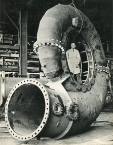
Photographs – SECV– Clover Power Station
The Junction Dam and Clover Dam Power Station, stages of the Kiewa Hydro-Electric Scheme, were needed to meet the increased power demands of the wartime industry in Victoria. Clover added 26 megawatts to the grid. Junction Dam was completed and ready to hold water by September 1943, but was emptied in December 1943 and not filled again until May 1944. Construction of Clover Power Station commenced in July 1941 and both turbines were in service by May 1945.Clover Power Station and Junction Dam were part of the Kiewa Hydro Electric Scheme constructed by the State Electricity Commission of Victoria.Set of 2 large black and white photographs of spiral casing for a turbine being transported to a power station on the Kiewa Scheme. Gentleman in lab coat standing inside casing in photograph 1 On the back – dark grey ink stamp “Photographed by / E.B. Studios / 309 George St., / Tel. SW 7373 Sydney” clover power station, secv -
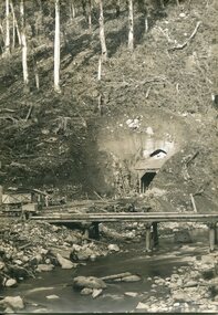
 Kiewa Valley Historical Society
Photograph – Photocopy of black and white photograph of Bogong Creek Race Line. 17/1/51, 17/01/1951
A start on the construction of Bogong Creek race line was made at the commencement of winter in 1948. Work proceeded in the following years when work on the High Plains was not practicable. In January, 1951 the special trimming machine, the special slip form and concrete mixing and placing equipment was put into service. A shortage of cement caused some delays as well as a sudden financial recession. The race line was completed and put into service in 1952.An historical record showing the machinery used during this time, the number of workers and supervisors involved and the mountainous terrain where they worked. It also demonstrates the OH&S of the period with workers mostly in street clothing with no hard hats or other safety equipment. Several workers can be seen working shirtless or in singlets.Photocopy of a black and white SECV photograph No: K 6209 labelled Bogong Creek Race Line ch. 1700. Depicting large group of workers and supervisors working at the site. Dated 17/1/52Printed underneath the photograph: STATE ELECTRICITY COMMISSION OF VICTORIA Date: 17/1/51 Time: 10.30am No: K 6209 Kiewa Hydro-Electric Works Bogong Creek Race Line ch. 1700 bogong creek raceline; secv; kiewa hydro electric scheme; -
 Kiewa Valley Historical Society
Papers - Centenary Bright-Tawonga Road, 19th March 1996
The Bright-Tawonga Road was built in 1896, connecting the Ovens and Kiewa valleys. The article gives an description of the event.The Bright - Tawonga road connected Tawonga to the larger town of Bright and the closest railway service. This road provided the Upper Kiewa Valley with access to larger markets, alternative transport and increased facilities not available in the Kiewa Valley in the early, pre SEC days. It describes how roads were built in 1896 with little machinery. The KVHS has in its collection the dray used to help build the road. One page article from the 'Shire News' dated 19th March 1996bright-tawonga road, road works, kiewa valley, ovens valley, dray -
 Kiewa Valley Historical Society
Four photographs of the Blue Duck Hotel and two Photos of the Glen Wills area, c1920 Post cards, c1949/50 small photographs
The Blue Duck Hotel stands at the confluence of 3 trout rivers - Cobungra, Bundarra and Mitta Mitta, called Angler's Rest. The original 1900's building was of slab construction and operated as a butcher shop, servicing miners on the track from Omeo to Mt. Wills. In 1912 it was purchased by a miner, Billy O'Connell, and he obtained a hotel license. In the early 1920's he transported 2 houses from Omeo on Horse drays. One is the main building of the Blue Duck and the other was a residence where Billy and his wife raised their nine children. The small log structure behind the pub is State School No.4286 where the children attended school. A teacher was shared with Glen Wills. By the late 1920's the hotel was discovered and patronized by keen anglers. Sir Harold Clapp (head of the railways) was one and he had the bronze blue duck cast and presented to the owners in the 1930's. This stands at the entrance to the premises.These photographs are of a building, in a remote area, that has provided a service to miners, anglers and travellers for over 100 years and continues to do so today. It also played a vital role in the history of the Mt. Wills/Omeo gold mining days.3 Post cards, Black and White photographs. 3 small black and white photographsPost Card No. 1 - "Blue Duck Hotel- Omeo-Glen wills road Ray Love Series No.2"(written on lower front) Post Card No. 2- "Looking towards Bogong High Plains. Omeo-Glen Wills road"(front, bottom, L hand) Ray Love Series No. 18 (front, lower R hand corner) On both of above photos, centre back, is stamped POST CARD and underneath this is printed "A GENUINE PHOTOGRAPH'/ Post Card No. 3 - Bottom L hand corner "Mystic Sea Australian Alps". R hand corner "(Bulmer Copyright)". Each small photograph, handwritten on back "Blue duck Hotel". All have circular stamp with "Print by Wilson White Albury" blue duck hotel; anglers rest; omeo highway; fishing; mining -
 Kiewa Valley Historical Society
Papers - A.L.P.S, Kiewa Valley, Women's Service Club, 1996
ALPS (Active, Life, Physical. Social) was formed c1996 to provide women with a service club that enables them to assist each other and the wider community. When forming the club, forms were created to guide their activities.ALPS is unique to the Upper Kiewa Valley involving women interested in meeting regularly and assisting their members and the community.1 green page titled 'The Pledge" 2 white pages stapled in the top left corner titled 'Protocol' 4 white pages stapled in the top left corner titled 'Ethics'alps, service club, women, kiewa valley -
 Kiewa Valley Historical Society
5 small black and white photos of Clover Dam and Power Station, c1948
The construction of Clover Power Station was commenced in October 1942 and the power station building was completed in May, 1943. The first machine was placed in service August, 1944 and the second machine in May, 1945. The water discharges directly into Clover Dam and re-used in West Kiewa Station. Clover Dam - stripping of foundation area commenced in January 1948 but the final concrete pour was not until 14th August, 1954.Pictorial history of the early construction undertaken in the building of the Kiewa Hydro Electric Scheme. Clover power station (No. 3 Development) was the first power station to be built .5 small black and white photographsPhoto No. 1 - handwritten in ink on back ' No. 3 Power Station Clover Flat Nov. 1948 Photo No. 2 - handwritten in ink on back 'No. 3 Power Station Clover Flat Nov. 1948 Photo No. 3- handwritten in ink 'Clover Flat looking towards work area of Clover Dam. Taken near #3 PS. Nov. 1948 Photo No 4 - Handwritten in ink 'Preparation for wall of Clover Dam Dec. 1948 Photo No.5 - handwritten in ink 'Preparation for wall o f Clover Dam Dec. 1948. Photo Nos. 1,2 3, on the back have circular stamp with 'Print by Willson White Albury'. In pencil is the number '78'. Photo Nos. 4, 5, have written on the back in pencil, number '14'. construction, clover power station, clover dam, -
 Kiewa Valley Historical Society
Banner, Gray-Y Banner
The Athletics Club under the guidance of a committee of workers, which included Mr Stan Hemmings and Mr Alec McCullough, sponsored a Junior Athletics Club which became the Gray-Y Club for young boys and HY-Y for older lads. Mr A E Clark (YMCA) had the idea of adopting the American Gray-Y System which was to instill in the boys good principles and values similar to those of the service clubs i.e. YMCA, the Masons and Buffalo Lodge. Story has it that the town was virtually crime free for many years. The Athletics Club became a very powerful force in Mount Beauty and assisted other fledgling groups to get started. The committee had the bright idea that they could raise money and entertain the men who lived in the outlying camps by running sporting exhibitions by their members and the Gray-Y boys for entertainment.It is a connection to the early history of Mount Beauty regarding the start of an athletics club.Blue material banner with gold fringe and inscription in middle.Red material triangle inserted within banner and red material H and I (overlapping) sewed into the middle of the triangletextile, youth club, mt beauty, athletics club, gray-y club, kiewa hydro electric scheme -
 Kiewa Valley Historical Society
Photographs – Kiewa Cres Mt Beauty. Circa 1993. Set of 12 colour photographs, circa 1993
Established in 1946, during the construction of the Kiewa Hydro Electric Scheme, the township of Mt Beauty was developed by the State Electricity Commission of Victoria to provide additional accommodation for the thousands of workers during the construction of the country’s second largest hydro-electricity scheme. Although these towns were built as temporary accommodation for the workers and their families, many stayed after the scheme finished. Combined with the influx of European migrants, with their rich cultural backgrounds, all played a major part in shaping the future character of the Mount Beauty, the Kiewa Valley and Falls Creek. The Bright Council, now the Alpine Shire took over the control of the township in 1960. This relatively young town of Mount Beauty, along with the surrounding townships of Falls Creek, Bogong, Tawonga South and Tawonga, are all part of a prospering tourist area with excellent services, accommodation, food and a wide range of recreational activities available for all ages. According to Shire records, the population of Mt Beauty has grown from 1,500 in 1981 to 1,800 in 2016 with a projected increase to 2,000 in 2013The photographs taken around 1993 show a prosperous commercial centre catering for both locals and the needs of visitors. It provides a pictorial history of the changes which have occurred in the retail/commercial district of Mt Beauty over the years. It also demonstrates the attention paid by Alpine Shire towards providing accessible recreational green space around the town centre.Set of 12 colour photographs Kiewa Cres Mt Beauty. Circa 1993 showing retail services and streetscape of the time. No markingskiewa crescent mt beauty; shopping centre; -
 Kiewa Valley Historical Society
Photographs – Set of 13 colour photographs of the street parade to celebrate the first Official Hoppet race run at Falls Creek in 1991, 1991
In 1977 a group of Mount Beauty cross country skiers formed the Birkebeiner Nordic Ski Club. In 1979, a version of the famous Birkebeiner race, the first Australian Birkebeiner was held at Falls Creek. In June 1990 representatives from Australia put their case for a southern hemisphere race in the series. Following a trial event in 1990. Australia became the 12th member of Worldloppet in the winter of 1991, with the first Kangaroo Hoppet. In 1991 a parade and commemorative torch lighting ceremony were organised in Mt Beauty as part of the celebrations to mark the first official Kangaroo Hoppett with participation from local community groups and commercial organisations, the Chamber of Commerce, local government representatives and individuals.Kangaroo Hoppet caters to diverse interests by offering a 42km and 21km event. It also offers a 7km event that attracts skiers, ranging from elite juniors to parents, grandparents, babies and first time skiers. It is recognised on the world cross country ski race calendar. It brings large numbers of participants and spectators to the area which support tourism, local businesses and employment. The 2018 event will be the 28th Kangaroo Hoppet, with cross country skiers travelling from across the country and overseas to compete.Set of 13 colour photographs of the street parade to celebrate the first Official Hoppet race run at Falls Creek in 1991. Participants were from a range of local community groups and local industry representatives. Photos were taken on Holland St. opposite the old hospital building. Following the parade, a market stalls were set up on the green outside the Community Centre on Holland St. as part of the Hoppet celebrations. 1 & 2- Boy Scouts and Cubs 3- UKV Lions Club 4 & 5- Local children representing the history and fauna of the High Plains 6- Ambulance Services 7, 8, 9 & 10 – Representatives and equipment from local forestry industry 11- Vintage truck by Vintage Charms Tours providing tours of the local area for visitors 12 & 13- Market stalls set up on the green outside the Community Centre on Holland St. as part of the Hoppet celebrations. kangaroo hoppet; ski race; cross country skiing; bogong high plains, mt beauty, parade, -
 Kiewa Valley Historical Society
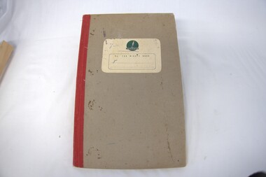
Book - Minute book of the Progress Association Ladies' Auxilary, Minute book of the Progress Association Ladies' Auxilary, 25th February 1960 to 29th February 1968
This is the 1st minute book for the Mount Beauty Progress Association Ladies Auxilary. The first meeting was held on 25th February 1960. At this time the construction of the Kiewa Hydro Electric Scheme was coming to a close and the town of Mount Beauty and its infrastructure was being handed over by the State Electricity Commission of Victoria (SECV) to the Bright Shire. Homes and businesses were sold and residents were having to 'fill in the gaps' for services that had been provided by the SECV.The Mount Beauty Progress Association was formed by community members to improve and enrich the lives of people in the early days of independence from the State Electricity Commission of Victoria as construction of the Kiewa Hydro Electric Scheme was coming to a close and the town and its infrastructure was being handed over to the Bright Shire.Foolscap Ritewell No. 246 Minute Book with red cloth spine and thick brownish cardboard cover. Label on front cover - Cream with "Ritewell (in green over logo) / No 246 Minute Book (printed in green)kiewa hydro electric scheme; bright shire; mount beauty progress association; fund raising. -
 Kiewa Valley Historical Society
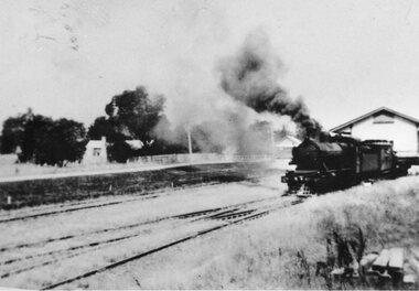
Photographs – Set of 3 black and white photographs of a building being transported by steam train
Prior to the sealing of the Kiewa Valley Highway in 1950, all heavy road stock including building materials, farm equipment and other heavy machinery had to be transported via railway lines to either Albury, Wodonga or Bright and then transported overland for the remainder of the distance by wagon on rough, poorly made roads. Trains also services the mining industries of the Ovens Valley and the transportation of tourists to Mount Buffalo and the very popular Mount Buffalo Chalet.Steam trains were a major form of transport for rural community members prior to the introduction of road transport. Local producers including farmers relied on rail transport to send and receive essential building equipment, farming produce, materials, stock and mail to maintain their lifestyles and social connections with the outside world. 3 black and white photographs of a building being transported by steam train. Photos show the train in three progressively closer photos. Photo shows a man standing in the doorway at the controls of the train, 3 figures, possibly children leaning out of the window of the carriage and another man, standing on the tracks with hands on hips. Photo could have been taken in Tallangatta, Cudgewa or Ebden near Lake Hume where trains were a major form of transport prior to the 1950’s. No markingstransportables; steam train; railway;, old tallangatta, esther temple -
 Kiewa Valley Historical Society
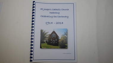
Book - Catholic Church Dederang, St Joseph's Catholic Church Dederang Celebrating the Centenary 1914 - 2014, 16th November 2014
Initially in the 1880s, services (known as stations) were held at Creamer's home in Dederang - generally x3 per year.In 1883 a small church was built where the present church now stands.This weatherboard church, St Joseph's, was replaced by a brick one in 1914 and opened on 8th Nov. 1914. The book has 9 chapters, the last one being 'Photo Gallery'. It covers the religious men, local families, newspaper snippets and records.Religion was an important part of life to people throughout the 20th century especially in a rural community as it gave people an opportunity to be part of the community and to socialize. This book gives a history of religion, of maintaining a church, of a rural community and of the Catholic religion.58 pages of printed history followed by 10 pages of colored photos in a spiral book with a blue spiral spine and a clear plastic cover. The front page includes the title in blue print with a colored photo of the church below the title.st joseph's catholic church dederang; kiewa valley; dederang families; catholic clergy; religion