Showing 661 items
matching south gippsland
-
 Orbost & District Historical Society
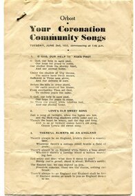
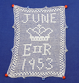
program, 1953
This program was produced by the Snowy River Mail for a community singalong held in Orbost on Tuesday June 2 1953 to celebrate the coronation of Queen Elizabeth 11. In June 1953 , Elizabeth II was crowned Queen of the United Kingdom, Canada, Australia, New Zealand, South Africa, Ceylon (now Sri Lanka), and Pakistan, and became the Head of the Commonwealth. The coronation of Queen Elizabeth II as monarch took place on 2 June 1953. Elizabeth ascended the throne at the age of 25, upon the death of her father, King George VI, on 6 February 1952, and was proclaimed queen by her various privy and executive councils shortly afterwards. The coronation took place more than a year later because of the tradition that holding such a festival is inappropriate during the period of mourning that follows the death of a monarch. This community event was typical of the general feeling of respect and admiration felt by the rural communities towards the British Royal Family. This item reflects the significance of monarchy for Australia and the constitutional history of Australia.The item reflects the interest in the royal family to Australians at this time as well as the general feeling of respect and admiration felt by the rural communities towards the British Royal Family.A white paper program with the words of songs printed in black. There is a rust mark from a metal staple in the top left corner. It is titled "Your Coronation Community Songs".queen-elizabeth-11 royalty community-event-orbost souvenir-program -
 Orbost & District Historical Society
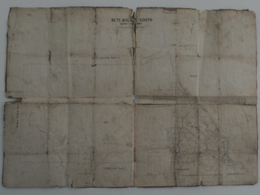
map, Bete Bolong South, March 8 1910
Orbost was at first included in the Bairnsdale Shire from 1882 and was later part of the Tambo Shire. This is a useful research toolA paper shire map of Bete Bolong South, County of Tambo.documents-map-bete-bolong tambo-shire -
 Orbost & District Historical Society
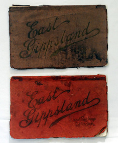
magazines, Atlas Press Pty Ltd, East Gippsland & Railway Extension, 10 September 1908
Orbost and East Gippsland Railway League had proposed a railway extension through East Gippsland in 1908, which aimed to develop an isolated part of the country. At the time, construction of a railway could be considered a beneficial investment for the country as it could increase the population in the region. The proposed railway length in 1908 was about 140 miles and the cost was estimated £800,000. The line was proposed to proceed from Bairnsdale by way of the Lower Nicholson to Bruthen. “After crossing the Tambo River, it would be carried to near Nowa Nowa; the head of Lake Tyers, forward to Orbost. From Orbost it would proceed in a north-easterly way to the New South Wales border. There were different suggested routes between Orbost and the New South Wales border, the first was through Bendoc, another by the Cann River and another which is located between these two. This item is associated with the history of the Orbost-Bairnsdale railway line and therefore reflects the role that the rail line played in the social and economic history of Orbost. The Bairnsdale-Orbost railway was opened in 1916 to serve the agricultural and timber industry. Because of the decline in traffic and heavy operating costs, the line was finally closed in August, 1987. Two small magazines showing the railway extension through East Gippsland. 678.1 has a dark maroon cover with gold print writing. It contains b/w photographs. 678.2 has a red cover with black print writing. Both are bound. 678.1 - inside front cover - M. Beattie ???????? Newmerella 678.2 - inside front cover - Gordon Fisher Orbosteast-gippsland-railway-league railway -
 Orbost & District Historical Society
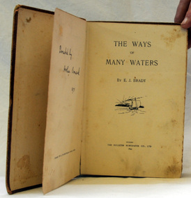
book, The Ways of Many Waters, 1899
This book of poetry by E. J. Brady was originally published by the Bulletin Newspaper Company (Sydney) in 1899,Later it was reprinted by Thomas C. Lothian (Melbourne) in 1909, and by the Standard Publishing Company (Melbourne) in 1913.] E. J. Brady was an Australian poet. He was born at Carcoar, New South Wales, and was educated both in the United States and Sydney. He worked as a wharf clerk, a farmer, and journalist, and edited both rural and city newspapers This book is culturally important as Edwin James Brady represented the Bulletin school of the 1890s. The Bulletin was very popular with rural bush workers and selectors and became known as ‘the bushman’s bible’. It encouraged contributions of poetry, short stories and cartoons from its readerswho included miners, shearers and timber-workers from all over Australia. Some of this content was high quality and many of Australia’s important writers had their start with The Bulletin which became know as the ‘Bulletin School’ of literature.A small 155 pp fabric covered brown book with a very faded picture of a boat sailing toward a sunset on the front cover.poetry literature brady-edwin-james the-ways-of-the-waters -
 Orbost & District Historical Society
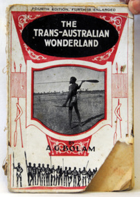
book, The Modern Printing Company, The Trans-Australian Wonderland, 1925
Born in 1893, Anthony Bolam was the Station Master at Ooldea Siding on the Trans-Australian Railway from 1920 to 1925. Bolam was very interested in Aboriginal culture and was a careful and sympathetic recorder of their lifestyle, customs and ceremonies. A keen photographer, he took many photographs of the Aboriginal people who congregated at Ooldea Siding in the early 1920s. Many of these photographs were included in this book. He died in 1966. This item is a useful research tool as it contains a contemporary description and photographsof the Aboriginal people of Ooldea, a tiny settlement in South Australia, on the eastern edge of the Nullarbor Plain. A small 134 pp book with a red and white cover which has a photograph of an Aboriginal holding a spear. The book has some full-page b/w plates and a folding map at the end.inside on front page - No. 58 -
 Orbost & District Historical Society
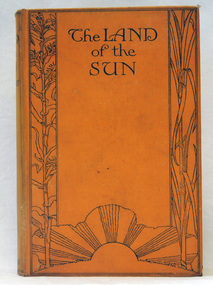
book, Butler & Tanner, The Land of the Sun, 1924
This is the author's account of life in Northern Queensland. Edwin James Brady was an Australian poet. He was born at Carcoar, New South Wales, and was educated both in the United States and Sydney. He worked as a wharf clerk, a farmer, and journalist, and edited both rural and city newspapers. Brady established a writers' and artists' colony at Mallacoota, in 1909, and he continued to live there until his death in 1952. E. J. Brady was a leading figure of Australian literature. He has an association with Mallacoota, a small town in the East Gippsland region of Victoria, Australia. A 303 pp book with a hard back cloth covered bright orange cover. It is titled in black print " The Land of the Sun" and has black print illustrations of crops and the sun. It contains black/white plates and a fold-out map of Queensland.brady-edwin-james book--the-land-of-the-sun queensland-northern -
 Orbost & District Historical Society
book, History of New South Wales, 1889
George Burnett Barton (1836-1901), lawyer, journalist and historian, was born on 9 December 1836 in Sydney. He practised journalism rather than law for which he had qualified in 1860. This is Volume 1 and covers the proposals for colonising New South Wales, the transportation and the early years of Governor Phillip.This is a detailed history of New South Wales compiled from original records and is a very useful research tool.A hard cover 625 pp book with a dark brown cover. On the spine the text is gold. It is titled, "History of New South Wales from the Records, Volume 1". It contains illustrations, facsimiles, maps, portraits and detailed historic information.Vol 1 1783-1789 Bartonnew-south-wales-history convict-settlement phillip-arthur barton-george-burnett -
 Orbost & District Historical Society
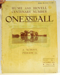
magazine, Clothier & Co, One And All, 1924
This magazine was circulated amongst the pupils, parents, and teachers of the Beechworth Inspectorate, North-East Victoria. This magazine is Vol. 2, no. 3 (Oct. 1924), Hume and Hovell Centenary Number.School magazines were the forerunners of today's school newsletters and were generally published annually. They are contemporary records of the students and staff of the school and usually contain examples of the students' work.This one, published to commemorate the centenary contains information on the Hume and Hovell expedition the purpose of which was to find new grazing land in the south of the colony, and also to find an answer to the mystery of where New South Wales's western rivers flowed. At the centenary of Hume and Hovell exploration in 1924 a committee was formed to co-ordinate and organise local celebrations along the route from Albury to Corio Bay. A roadside cairn was unveiled near Beechworth.A stapled school magazine with a cream coloured cover. It has an illustration of a river and trees reflected in the water on the front. The title, "ONE AND ALL" is at the top in black print. It has " Hume and Hovell Centenary Number" above the title.education-beechworth school-magazine-one-and-all -
 Orbost & District Historical Society
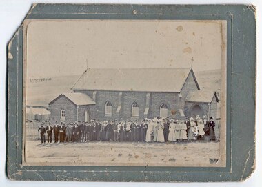
black and white photograph
This is possibly a wedding photograph related to an Orbost family.A black / white photograph, on a grey buff card, showing a large group of people, probably a wedding party, outside a brick church in Bega, New South Wales.on front at bottom - "Wood - Bega"photograph-church-bega -
 Orbost & District Historical Society
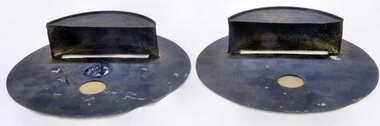
shields - blackout, Swan, Wally, WW11
By 1941, the threat of Japanese invasion caused restrictions to daily life. Blackouts became the norm. To prevent identification from enemy planes all lights had to be turned down, including car headlights that had to be covered to minimize light exposure. In Australia more relaxed regulations led to the Australian air raid precautions being dubbed the “brownout”. These shields limited the amount of light emitted by a vehicle. To drive at night without them was an offence; however, the increase in road accidents led to the removal of headlight masks everywhere in Australia south of Rockhampton from 15 February 1943.These shields, though not rare, evoke a period of restrictions, fear, rationing and confinement.Pair of handmade car light blackout shields. Black round metal with scoop at front as well as small glass partition.shields-blackout ww11 transport-motor-vehicles -
 Orbost & District Historical Society
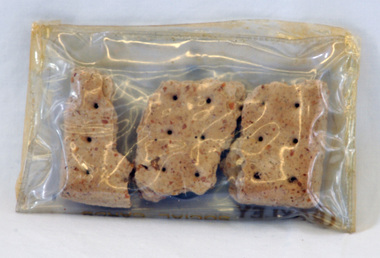
biscuit rations, c. 1899
These biscuits were supposedly issued to Jacob Perry when he served in the Boer War in South Africa in 1899. Jacob Perry was a member of an early family in Orbost and these biscuits were donated by George Perry. Hard tack biscuits were part of a soldier's individual ration in the Boer War and were so hard that they were often soaked in water before consumption if this was possible. Made of 13 parts flour to one part of water, the biscuits were slowly dried in the baking process, rendering them so hard that they deterred attacks from weevil pests and allowing them to be transported with little breakage. Hard ration biscuits were a staple of soldier's diets. This item is an example of an early ration supplied to soldiers serving overseas.Three dry biscuits, hard tack, roughly rectangular shape and with 6 prick holes.army-biscuits boer-war-biscuits -
 Orbost & District Historical Society
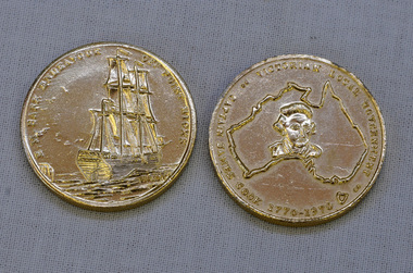
coins, Victorian Local Government, 1970
These coins were made as part of the 200 year celebration of Captain James Cook's voyage on the HM Endeavour and the first sighting of Australia at Point Hicks in 1770. These two coins were presented to Orbost Historical Society by the Orbost Branch of the Bank of New South Wales in 1970.These coins were made as part of the 200 year celebration of Captain James Cook's voyage in 1770 and reflect the importance of that historic event.Two silver coloured coins. On one face is the image of a sailing ship and the words HM BARK ENDEAVOUR OFF POINT HICKS and on the other face is a map of Australia with a head portrait of Capt. Cook in its centre, and the words CAPTAIN JAMES COOK 1770-1970 VICTORIAN LOCAL GOVERNMENT around the edge.as abovecoins celebratory-coins captain-cook australia-discovery -
 Orbost & District Historical Society
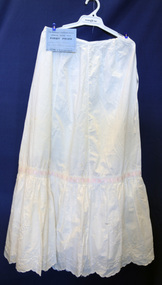
petticoat, Cowell, Alice, 1914
Handmade by Alice Cowell as an entry for the annual Bombala (southern New South Wales) Show.This item is an example of a handcrafted item and reflects the needlework skills of women in the first half of the 20th century.A white machine-made petticoat with hand embroidery and pink ribbon threaded around middle. It has broderie anglaise along scalloped edge and comes with a blue certificate for First prize at the Bombala Annual Show.petticoat costume female-underwear handcrafts dress-making -
 Orbost & District Historical Society
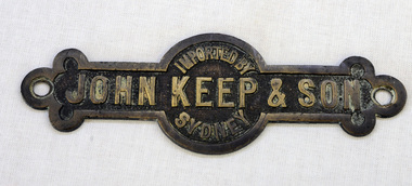
label
The hardware firm of John Keep and Sons, Ltd., was founded in 1853 by Mr. John Keep. Mr. John Keep started the business on the south-western corner of George and King streets in Sydney. In 1883 the firm removed to Clarence and King streets.A brass metal label with "Imported by John Keep & Son, Sydney:" imprinted on it. label commerce keep-john -
 Orbost & District Historical Society
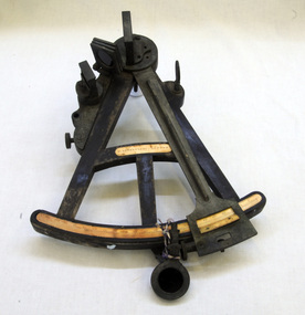
sextant, W. Sutherland
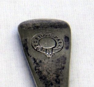
RIDGE PARK, Length: 65.2 m.; Owned by H. Simpson & Sons; Built at S. P. Austin & Sons in 1878. Registered at Adelaide. On 10 February 1881, RIDGE PARK (Capt. Heslop) was on voyage from Adelaide to Sydney with a cargo of brandy, wine and flour, when she was lost after running aground.Beware Reef is located south east of Cape Conran in east Gippsland. This is the sextant from the Ridge Park which, on10 February 1881, was wrecked on Beware Reef , just south of Cape Conran in east Gippsland. An old wooden sextant from the ship, Ridge Park. It is black with yellow measuring stripes.sextant maritime navigational -
 Orbost & District Historical Society
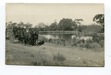
black and white photograph, late 19th - early 20th century
This photograph was taken at the junction of the Snowy and Brodribb Rivers. The Snowy River starts in New South Wales on the slopes of Mt Kosciuszko, Australia’s highest mountain, in New South Wales. It flows into Bass Strait at Marlo in Victoria. The Brodribb River is a tributary of the Snowy which enters the estuary at Marlo. This is a pictorial record of a road in Marlo near Orbost in the late 19th-early 20th centuries. It also depicts the transport used at that time.A black / white photograph of four men in suits seated in a horse - drawn buggy on a dirt road alongside a creek or river. There appears to be another horse - drawn vehicle behind them.on back - "at the Brodribb - Snowy junction. this road was corduroy (packed logs of tea trees?)brodribb-river snowy-river marlo transport-horse-drawn -
 Orbost & District Historical Society
black / white photograph, 1897
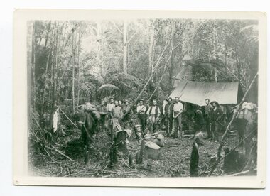
Link with item 1178. This is a surveyors' camp in the McCulloch Ranges, Murrangowar, April, 1897. Included in the photograph are: L. Thorn; Pearson; L. Coburn, Clem Bates; Sam Blacklock with a packhorse. They were surveying for a road or railway. Surveyors were among the first European settlers to arrive in Australia. A Surveyor-General was present on the First Fleet, as well as the first two ships which landed in South Australia. These men were issued with instructions to record observations in a journal that included the country’s general appearance, its soil, flora and fauna and the customs and language of local inhabitants. The conditions they worked in were harsh and they embarked on journeys with drays carrying cumbersome surveying and camping equipment, spending months camping out in the bush and mapping the land. It was not until well into the second half of the nineteenth century that the professional training of surveyors became mandatory in Australia.This is a pictorial record of a surveyors' camp in the late 19th century.A black / white photograph of a group of men standing in front of a tent / camp in a dense bush setting.surveyor's-camp-mccullochs-ranges-murrangowar land-settlement -
 Orbost & District Historical Society
black and white photograph, 1920s
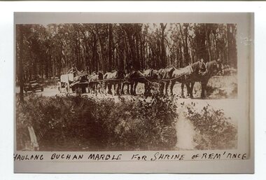
The Shrine of Remembrance was created to meet the needs of a grieving community after the extensive loss of lives in the First World War (1914 –18). sixteen dark Buchan marble Ionic columns. In the early 1900s black marble was being mined in the Bruthen district. Some was used for the Shrine of Remembrance in Melbourne and Australia House in London. 900 tonnes were shipped to London to be included in the construction of Australia House. Marble quarrying has been a significant part of the history of Buchan in East Gippsland. Its inclusion in the Shrine of Remembrance War Memorial is noteworthy.A black / white photograph of a team of eight horses hitched to an open top cart. The cart is loaded with lrge slabs of marble. The driver is on top of the load. It is on a gravel road in a forest. The photograph has a grey frame background.om front - "HAULING BUCHAN MARBLE FOR SHRINE OF REM'ANCE"marble-buchan quarry-marble-south-buchan shrine-of-remembrance -
 Orbost & District Historical Society
black and white photograph, C 1920
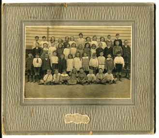
Phyllis May Waller was born Orbost in 1912. Her father-was Frank Hale Waller and her mother -Sarah Elizabeth Clancy. Phyllis married Clive Howell Crawford Pasco in 1934 (Clive was born 1908 at Prahran, and died in 1971 at South Melbourne). "The 19th of March 1886 proved an important day in the lives of many early settlers in the Orbost area, because on this day the Orbost State School opened. The fact that the school had first operated temporarily in a leased building, and on a half-time basis with SS2745 Jarrahmond, did not dampen the enthusiasm of the local inhabitants as they saw their offspring commence their education under the guidance of HT Campbell Mackay. However he remained in charge only until 12th of May 1886. The second HT, John Rowe, served until 1908. On 30th of June 1887, a portable room was provided; it being brought to the area by schooner. The school now had accommodation for 30 pupils; the teacher's welfare was considered because quarters of two rooms were attached. As the population increased so did the needs of the school. This was reflected in the provision of a larger classroom in 1898. During 1910-11 the first approaches were made to the Department for the establishment of a HES in Orbost and this became a reality in 1912. Orbost HES supplied post-primary education in the district until a high school was built in 1948. When fire destroyed the school in 1941 local halls were used as classrooms until a new school was built. Work was quite rapid and a new brick structure was opened by the Hon. A. E. Lind, MLA, on 13th of February 1942. This new building was a fine type of school of which both the pupils and the HT Leslie Collins were indeed proud. But Orbost continued to develop and the new school was soon overtaxed. This resulted in the erection of two Bristol classrooms in 1947. By 1950, when the school population had reached 500 pupils the opening of the new school at Orbost North was welcomed by all concerned. In 1963 the Department purchased land diagonally opposite the school and developed it as a playing area. In 1965 two LTCs were opened in November, and in October 1968 the Brodribb School building was moved to SS2744 Orbost for use as a general purpose room."This item is associated with the history of education in Orbost. It is also associated with the Waller family, early settlers in Orbost.A black / white photograph on grey card. Against a wooden building are four rows of young children. The front row of the youngest children is sitting with crossed legs.The back three rows are tiered. the children appear to be dressed in their best clothes with many of the boys wearing ties. There is a photographer's label at the bottom.on back written by older son -"Orbost State School Approx. 1920 Mum (Phyllis May Waller) 6th from left 2nd back row"waller-phyllis-may -
 Orbost & District Historical Society
black and white photographs, 1980s? (winter months)
All photographs seem to have been takenfrom the Telecom tower on the corner of Browning and Wolseley Streets in Orbost 3259.1 is a view of the Orbost township looking north-east. The swimming pool and bowling club can be seen in the foreground. 3259.2 is aview looking north-west and showing the tennis courts and clubhouse, the Recreation Reserve oval, the Youth Centre, Historical Museum, Municipal Offices, Senior Citizens clubrooms with the fire station in the foreground. 3259.3 is a view looking south with the Shire of Orbost Municipal offices and Ruskin Street in the foreground. Munro Street can be seen running from Ruskin Street to St Joseph's School in the middle distance. Lochiel Park oval, Lochiel House, the Snowy River and highway bridge are in the background. 3259.4 is a view looking south showing the Club Hotel, C.B.C. Bank in the middle distance and Hoffman's paddock (Forest Park) and the Snowy River beyond. 3259.5 is a view looking north-east over houses. 3259.6 is aview over the main street, Nicholson Street.showing the main shopping precinct. Shop signs for Permewans, Williams Shoes, F.B. Dicken and Orbost Bakery can be seen. 3259.7 is a view looking south west and shows Forest park and beyond towards Bete Bolong.These photographs are detailed pictorial records of the township of Orbost.Seven black / white photographs taken from above a township. Chimney smoke can be seen in the photographs.orbost-township-1980s aerial-photograph-orbost -
 Orbost & District Historical Society
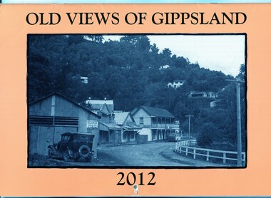
calendar, Old Views of Gippsland 2012, 2011
This item is one of a series of calendars published annually by East Gippsland Historical Society.This item is a useful reference tool.A 2012 stapled calendar, titled "Old Views of Gippsland". On the light tan coloured front is a black/white photograph of Main Road Walhalla looking south towards the Star Hotel C / 1951. It contains early photographs of East Gippsland, one for each month. There is a hole for hanging.The title is at the top and the year at the bottom in black print. -
 Orbost & District Historical Society
coloured photographs, 1948 1954 ?
These photographs were probably taken in the late 1940s - mid 1950s. 3275.1 was taken at the roundabout in Nicholson Street / Salisbury Street intersection looking south. On the right is the The Commonwealth Hotel and the Gippsland Northern Store can be seen on the right. The war memorial can be seen in the centre of the intersection. 3275.2 has been taken from a height (possibly from behind the hardware store) overlooking Orbost House in McLeod Street. The butter factory can be seen in the background. Back yard toilets and paling fences can be seen with a narrow lane for the sanitary truck. Mrs Ruth Hannah Macalister, 1861-1932, established “Orbost House” as a boarding house in about 1900. Following her demise “Orbost House” was taken over by her son, “Reg” and his wife and they continued the Macalister family‟s association until the accommodation house was purchased by “Slim” and Eileen Somerville and Lindsay and Joan Jensen, in partnership, in 1963. (info. from Marilyn Morgan)These photographs are detailed pictorial records of Orbost in the mid 20th century. They show the objects in their spatial context with detail.Two coloured photographs. 3275.1 is a streetscape with a large hotel on the right, a main shopping area in the background and a wooden fence on the left. 3275,2 is overlooking backyards and fences. In the middle is an extensive red roof with "ORBOST HOUSE" in white print.on back - 1948-1954orbost-1950s orbost-house commonwealth-hotel -
 Orbost & District Historical Society
black and white photographs, 1984
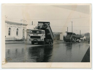
These photographs were taken in the main street of Orbost looking south along Nicholson Street. Nicholson Street was remade in 1984 with new kerb alignments, the introduction of red brick paving and the planting of oak trees. This has since been changed.These photographs are pictorial records of construction in the main street of Orbost.Two black / white photographs of roadworks. 3278.1 is of two tip trucks on a newly sealed road. The commonwealth Bank is on the left and in the background is a sign to "COIN LAUNDRY'. 3278.2 is of three men at the edge of the road, backs to the camera.3278.1 - on back - "Resealing of Nicholson Street, Orbost, 1984" 3278.2 - on back - "Peter Dreverman in middle"orbost-nicholson-street construction-nicholson-street roadworks streetscape -
 Orbost & District Historical Society
black and white photographs, C 1960s - 1970s
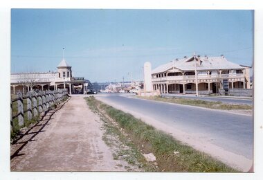
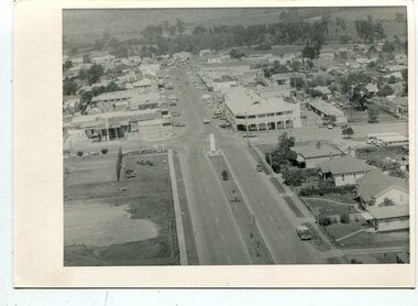
3290.1 is an aerial photograph of the township of Orbost looking south along Nicholson Street. The tennis courts and recreation reserve are on the left. The War Memorial, Commonwealth Hotel at the Saisbury Street intersection is in the centre of the photograph. 3290.2 is an aerial view of the Orbost township looking north, showing the bridge across the Snowy River in the foreground,These photographs are detailed pictorial records of the Orbost township C 1960s - 1970s.Two photographs which are aerial views of a township showing streets, buildings and vehicles. 3290.1 is a black / white photograph. 3290.2 is a coloured photograph.orbost-township-c1960s-1970s aerial-photograph-orbost -
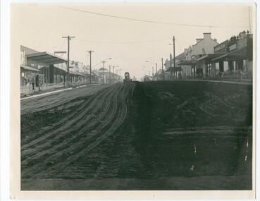
 Orbost & District Historical SocietyThis photo is of Nicholson Street, Orbost, taken from the south and looking northwards. This is the main street in Orbost, with most of the businesses, banks etc. in this street. In 1984, Orbost Shire Council proceeded to do a refurbishing of the main street and this photo is likely from that time. This photo shows one of the steps in the progression of Orbost. B/W photograph of a street with buildings on rt. and left and a grader or earth moving equipment working in the background on the street. This photo is H-200mm W-254mm.orbost - nicholson street - streetscaping
 -
 Orbost & District Historical Society
Photograph - black and white photograph, Nicholson Street 1984 works
This is a photograph of Nicholson Street, Orbost taken from the south and looking northwards. Nicholson Street is the main commercial street of Orbost and this photo is of a re-shaping of the street done in c. 1984 by Orbost Shire Council. Shows evidence of the maintenance works done to refurbish the main street of Orbost A B/W photograph H-20cm W-25.4cm of a street with buildings on both sides of the street. A piece of earth-moving machinery is working in the background on the street. nicholson street, orbost -
 Orbost & District Historical Society
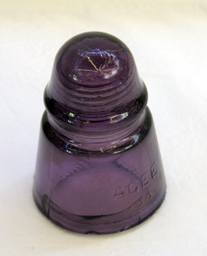
insulator, 1926 to 1940 (probably 1930)
This insulator was used on phone wires. Insulators were originally designed to keep the wires linking telegraphs and telephones insulated from the wooden poles that held them aloft. Prior to 1925, Australia relied solely on insulators imported from other countries. Glass insulators were first manufactured in Australia in c. 1926 by Australian Glass Manufacturers. Their factory was, and still is, located on South Dowling Road in Sydney. Australian Glass Manufacturers (A.G.M.) had developed a toughened type of glass very similar to Pyrex glass. Since the Pyrex name could not be used due to trademark infringements, they called their glass AGEE for Australian Glass. Many fruit jars, insulators, pie dishes and other glass items were manufactured with this AGEE trademark during the 1926 to 1940 period.Glass insulators are rapidly becoming a thing of the past in Australia with open-wire communication lines rarely existing near metropolitan areas. The remaining open wire lines are being abandoned and dismantled everywhere with very few insulators being saved as interest in them in Australia is quite limited. (ref Australian Insulators web-site). This item is an example of a piece of equipment which has been superceded.A glass telegraph line insulator of double umbrella shape. Glass is coloured purple - AGEE 30 Insulator. It is a tapered cone of thick glass. The inside top is threaded for screwing onto the metal piece on a wooden cross bar.Embossed on outside of bell: "AGEE 30"insulator-glass agee a.g.m. communications telegraphy -
 Orbost & District Historical Society
jug cover, 1953
this item was made to commemorate the coronation of Queen Elizabeth !! in 1953. In June 1953 , Elizabeth II was crowned Queen of the United Kingdom, Canada, Australia, New Zealand, South Africa, Ceylon (now Sri Lanka), and Pakistan, and became the Head of the Commonwealth. Many souvenirs were made to mark this occasion. Some were unique and hand-made. The main sources for crochet and other needlework designs available to women were in journals, magazines and pattern books.This milk jug cover reflects an important pastime for Australian women of the late 19th to mid 20th century. Women's focus was the home and its decoration was important. Embroidery and crochet work was an affordable way to personalise and add aesthetic value, and examples of embroidered and crocheted pieces could be found in most Australian homes, decorating or protecting furniture, floors and walls, and keeping flies and insects away from food. It is also a tangible souvenir of the coronation of Queen Elizabeth 11.A rectangular jug cover hand crocheted in white thread. It has blue and red beads sewn into the edges. the design is "JUNE" above a crown with "E 11 R 1953" below the crown. -
 Orbost & District Historical Society
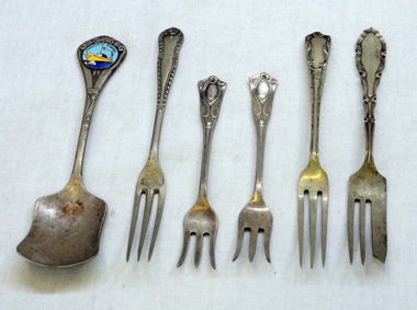
cutlery, first half 20th century
MS Princess of Tasmania was an Australian-built roll-on/roll-off passenger ship, built by the State Dockyard in Newcastle, New South Wales for the Australian National Line. Laid down on 15 November 1957, she was launched on 15 December 1958. The Princess of Tasmania sailed on her maiden voyage on 23 September 1959. On entering service, she was used on the Devonport to Melbourne route across Bass Strait. The ship continued operating until 1972, Five silver-plated forks and one spoon. The sugar spoon is a souvenir of the Princess of Tasmania. 1590.2 and .5 are narrow forks. 1590.3 and .4 have splayed tines. 1590.6 is a cake fork.On back of spoon : EP&NS *1 Various marks on backs of forks with EP&NScutlery silver-plated princess-of-tasmania -
 Orbost & District Historical Society
cutlery, 1880's
RIDGE PARK, Length: 65.2 m.; Owned by H. Simpson & Sons; Built at S. P. Austin & Sons in 1878. Registered at Adelaide. On 10 February 1881, RIDGE PARK (Capt. Heslop) was on voyage from Adelaide to Sydney with a cargo of brandy, wine and flour, when she was lost after running aground.Beware Reef is located south east of Cape Conran in east Gippsland.This cutlery is from the Ridge Park which, on 10 February 1881, was wrecked on Beware Reef , just south of Cape Conran in east Gippsland.Two forks and two spoon which are silver plated dinner cutlery.On front of handles - S.S.Ridge Park On back of handles - EP & NS with an A inside a circle