Showing 748 items
matching stokes and sons
-
 Warrnambool and District Historical Society Inc.
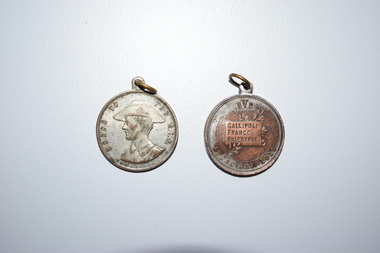
Medals, Stokes & Son, Anzac Day 1918, 1918
... Stokes & Son ...These medals were produced for Anzac Day 1918 by the Education Department of Victoria and made by the Melbourne firm, Stokes and Son. They were issued to Victorian school children and also sold to aid the war effort. These medals have no particular local provenance but are retained for display purposes..1 A silver-coloured metal medal with an image of an A.I F. soldier and printed words on the obverse side and a banner and decorative leaves and printed words on the reverse side. The medal has a metal circular piece at the top for attachment to a ribbon or cord. .2 as above except that the medal is bronze-coloured. EDV Gallipoli France Palestine Anzac Day 1918 Honor to the AIF S & S world war one, history of warrnambool, anzac day -
 Ringwood and District Historical Society
Book, Deaton & Spencer Pty. Ltd, The Local Government Handbook (Victoria) - Second Edition 1948, 1948
Blue hard cover reference book by F.H. Lonie of Maddock, Lonie and Chisholm, solicitors to the Municipal Association of Victoria. A concise explanation of the Local Government Act and procedure at Council meetings.Dedication (by Leigh Blackburn) - To my son Peter James Blackburn 1945-1991 who shared with me my association with the Stokes company. Foreword by F.A. Jenkins, Secretary, Municipal Association. -
 Glenelg Shire Council Cultural Collection
Medal - Medal - opening of the first federal parliament, 1901, \, 1901
Medal issued to commemorate the opening of the First Federal Parliament of Australia on 9 May 1901. The silver medal was minted by Stokes & Sons and presented to MLA Thomas Bent. Knighted in 1907, Bent served as Premier and Treasurer of Victoria from 1904-1909.At top of red ribbon Australian Arms over blue enamelled ribbon AUSTRALIA, below busts of Victoria and Edward VII in ovals; above, AUST. COMMONWEALTH / EST.1.JA.1901 / 63D. OF VICTORIA, R.I; below, FIRST PARLIAMENT OPENED / MAY 1901 / 1ST OF EDWARD VII / W.A. TAS. N.S.W. VIC. S.A. Q'LD. Reverse: Busts of the Duke and Duchess in ovals; above, OPENING OF THE FIRST / FEDERAL PARLIAMENT; below, T.R.H. / THE DUKE AND DUCHESS OF CORNWALL / AND YORK / MELBOURNE, MAY 1901Front: Inverse: Opening of the first/Federal Parliament/T.R.H./The Duke and Duchess of Cornwall/-and York-/Melbourne, May 1901. Back: Obverse: Aust. Commonwealth/Est. 1 Jan. 1901/63 D. of Victoria. R.I./First Parliament opened/May 1901/1st of Edward VII/ W.A. TAS. N.S.W. VIC. SA. QLDcelebration, numismatics, medal, federal parliament, 1901 -
 Warrnambool and District Historical Society Inc.
Medals, Stokes Melbourne, Industrial & Art Exhibition 1886-7, 1896
... Stokes Melbourne ...These are souvenir medals of the Warrnambool Industrial and Art Exhibition of 1896-7. This exhibition organised by a local committee under the chairmanship of the Mayor, Walter Hickford was one of the most important events in Warrnambool's history. It ran for three months and was said to have attracted 70000 visitors. It was held in Liebig Street and utilised both the civic centre buildings and temporary buildings erected for the event. It had several exhibition courts featuring art worksand business exhibition stands, competitions,entertainments and visiting experts in various fields. These medals were made at the exhibition at the stand of Stokes and Son. Visitors to the exhibition were able to get a gold silver or bronze medal made while they watched and the medal was then perforated ready to put on a watch chain or pendant. Thomas Stokes came to Australia in the 1850's and established a successful business in Melbourne manufacturing buttons, medals and tokens. The business was called Stokes and Son following a fire in 1893.These medals are of great significance as a memento of an important event in Warrnambool -The Warrnambool Industrial and Art Exhibition of 1896-7. Medals such as these would have been in the homes of many residents of Warrnambool and district and beyond after 1896..1 This silver circular medal has text around the outer rim and an image of Queen Victoria on the reverse. On the obverse is text and an image of the Warrnambool Exhibition building erected for the occasion. The medal is secured by a red thread , button and clear tape to a piece of card. On the card is a hand drawn sketch the Warrnambool Exhibition building and a hand drawn sketch of a profile of Queen Victoria . .2This silver circular medal has text around the rim and an image Warrnambool Exhibition building on the reverse and on the obverse a stylised coat of arms topped by the rising sun . Inside the field is a sailing ship, a pick and shovel , a sheep and sheaf of wheat .1 on the Reverse : around the rim, Struck at the Exhibition mint. On the obverse : Industrial exhibition 1896 Warrnambool. .2 On the obverse : Industrial exhibition 1896 Warrnambool.warrnambool, great exhibition of warrnambool, 1896 exhibition warrnambool, warrnambool exhibition medal -
Glenelg Shire Council Cultural Collection
Artwork, other - Collection of ephemera relating to work by cartoonist Bruce Cavalier, n.d
Collection of ephemera relating to work by cartoonist Bruce Cavalier who was the son of Portland Cr. Frank Cavalier. Designed poster for Portland's 150th Celebrations (5398). Laminated version 751 (see other information for list of items). Letter and copy from Margaret Morrison to Gordon Stokes. Photocopies - 11 cartoons Photocopy - sign 'Cavalier Park' " - 2 newspaper articles " - Testimonial Dinner Cartoonists Club " - 3 Eulogies -
Glenelg Shire Council Cultural Collection
Medal - Medal - Queen Victoria's Jubilee, 1887
Australia Victoria Portland Jubilee of Queen Victoria 1887 (AD) Mint: Stokes & Sons Other Details: Medal issued in 1887 by the Town of Portland to celebrate the 50th jubilee of Queen Victoria's ascension to the throne. It names W.T. Pile as Mayor. William Thomas Pile served as Mayor from 1887 to 1888.Gilt Queen Victoria jubilee medal. RoundHead of Queen Victoria facing left, wearing veil and coronet; Around, VICTORIA'S JUBILEE Below, 1887. Inscription on truncation of Queen's neck: H.S. Reverse Description At centre within broad ornate, zigzag border Town Hall building; around above, TOWN HALL PORTLAND; In exergue: W. T. PILE ESQ. / MAYORcelebrations, queen victoria, medal, numismatics, victoria, golden jubilee, 1887 -
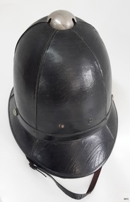 Flagstaff Hill Maritime Museum and Village
Uniform - Policeman's helmet, A W Sudweeks, 1877 to 1947
This is an original policeman’s helmet, known as a ‘Wolsley’. The design was in use by Victoria Police from 1877 to 1947 then replaced by more suitable caps. The helmets were made in Ballarat by the Victoria Police's official supplier, A W Sudweeks. Some of these helmets were re-sold at Stokes and Sons in Melbourne and would carry that company’s name. This Victoria Police helmet represents an early era in its uniforms, from 1877 to 1947, when the design was based on the English versions. The design was later replaced by head wear that better suited the local climate and conditions. Helmets of a similar shape to this one were worn by the local Volunteer Corps.Policeman’s helmet, Victoria Police. The black, stiffened canvas hat has a high crown and a leather chin strap. The five panels of stiffened canvas are stitched together. The helmet has a metal ventilation dome at the top. The two small holes at the front are for the officer’s identification badge. The helmet has a leather sweatband, and the brim and sweatband are lined with beige fabric. The helmet’s brim is wider at the front. A maker’s label in the shape of a shield is attached inside the helmet, which is made by A.W. Sudweeks of Ballarat. "A. W. SUDWEEKS / MANUFACTURER / BALLARAT"flagstaff hill, warrnambool, maritime museum, maritime village, great ocean road, shipwreck coast, police, victoria police, police uniform, policeman's hat, helmet, policeman's helmet, wolsley, law and order, victorian government, bobby, stokes and sons, official supplier, government supplier, a w sudweeks, ballarat -
 Linton and District Historical Society Inc
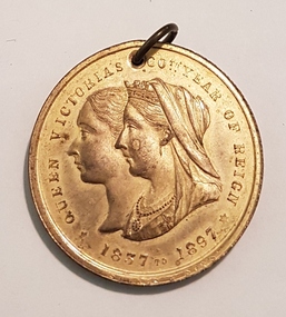
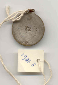
Medallion, Queen Victoria's Diamond Jubilee Celebrations, 1897
Queen Victoria's Diamond Jubilee was celebrated enthusiastically across the British Empire. Commemorative medallions were produced and distributed by the Victorian government and many local governments. Two medallions produced for this occasion by the Shire of Grenville are in the LDHS collection. One of these is believed to have been presented to schoolgirl Mabel Cluff, of Linton State School. The medallion which was presented to Mabel Cluff was donated to LDHS in 1995. Acquisition of this medallion is acknowledged in "Society Notes", Number 118, July 1995, but donor's name is not recorded. For reasons unknown these two medallions were not catalogued until 2016.Round, gilt bronze medallion, on the obverse two conjoined faces of Queen Victoria, one as a young girl, the other as an older woman. The phrase "Queen Victoria 60 Years of Reign" and the dates "1837-1897" around the perimeter. "Stokes and Sons" imprinted in tiny letters on the extreme lower edge. On the reverse, an image of the Shire of Grenville offices in Linton, with the word "Linton" underneath. "Shire of Grenville" & "Victoria" around the perimeter. Medallion has small metal loop through hole at top.queen victoria, medallions, diamond jubilee, shire of grenville, mabel cluff -
 Ballarat Tramway Museum
Badge - SEC pass - set of 27, AMOR, c1950?
Set of 27 Stamped enamelled round brass pieces with a hole stamped at the top and ring placed through. Used as a SEC tramways employees pass for either all Provincial tramways, Ballarat or Bendigo only. All badges have the SEC logo in the centre, organisational name (State Electricity Commission of Victoria) in white enamel and outer ring the words "Electricity Supply Department, Provincial Tramways", or "Electric Tramways Ballarat" or "Electric Tramways Bendigo". This is in blue enamel. On the rear are stamped numbers and manufacturers name - "AMOR" or "AMOR MELB" or "STOKES & SONS MELBOURNE" in the bottom portion of the pass. Items .1 -> .10, .12, .13 individually tagged. Item .11 not tagged Item .13 -> .27, single tagged, tied together with a length of string. 1941.1 - Bendigo - No. 9 - Stokes - silver background instead of gold, appears to have been used. .2 - Bendigo - No. 43 - Stokes - has been used - partially worn, has additional clip joined to main ring. .3 - Ballarat - No. 51 - Stokes - has been used, worn and chipped under main ring. .4 - Ballarat - No. 61 - Stokes - has been used, worn, and chipped on blue enamel in at least two places. .5 - Ballarat - No. 72 - Stokes - has been used, worn and chipped on blue enamel in many places - btm1941i1 for reverse side. .6 - Ballarat - No. 86 - Stokes - has been used, worn, dirt on rear - see image btm1941i2 for front side. .7 - Bendigo - No. 107 - Stokes - appears not to have been used - see image btm1941i3 for front side .8 - Bendigo - No. 108 - Stokes - ditto, but gold by SEC shield is discoloured - see image btm1941i4. .9 - Bendigo - No. 121 - Stokes - appears to have been used, more silver than 1941.8 .10 - Provincial - No. 124 - AMOR - may have been used - see image 1941i5 for front side .11 - Provincial - No. 156 - AMOR - small clip broken off at top, has been used, worn (Not tagged) .12 - Provincial - No. 306 - AMOR - no larger ring, has been used, worn and discoloured .13 - Provincial - No. 656 - AMOR MELB - has not been used, no larger ring, see image 1941i6 for back side. .14 - Provincial - No. 642 - AMOR MELB - has not been used. .15 - Provincial - No. 644 - ditto .16 - Provincial - No. 645 - ditto .17 - Provincial - No. 646 - ditto .18 - Provincial - No. 647 - ditto .19 - Provincial - No. 648 - ditto .20 - Provincial - No. 649 - ditto .21 - Provincial - No. 650 - ditto .22 - Provincial - No. 651 - ditto .23 - Provincial - No. 652 - ditto .24 - Provincial - No. 653 - ditto .25 - Provincial - No. 654 - ditto - to A. Reither for 21st from BTM 2/8/03 - see attached image btm1941i7 .26 - Provincial - No. 655 - ditto - to P.Mong for 21st from BTM 2/8/03 - see ditto .27 - Provincial - No. 564 - ditto - added 21/1/2007 from somewhere - at WAD's house 12/2006. .28 - Provincial - No. 589 - ditto - dittotramways, trams, employees pass, tickets, provincial tramways, badges -
 Melbourne Tram Museum
Badge - MTOCo lapel, 1900's
Lapel Badge for the Melbourne Tramway and Omnibus Co. staff. Has an abbreviation of "MTOCo" to indicate the tramway operator and worn as part of their uniform. No manufacturer's name on the rear of the badge, though possibly made by Stokes & Sons Melboune. Three copies held, two fitted with a clip - as shown in the photograph. See Reg Item 1923 for a photo showing how it was used for a Conductor's uniform.Demonstrates a item worn on a MTOCo Uniform. Made from a cast brass item, nickel plated, cast in the form of handwritten or script letters. On the rear, silver soldered on are two brass loops at either end of the badge to enable the badge to be sewn or fitted with clips onto the cap or the uniform.trams, tramways, uniforms, cable trams, mtoco -
 Dandenong/Cranbourne RSL Sub Branch
Medal - Peace Medal - Triumph of Liberty and Justice Australia 1919
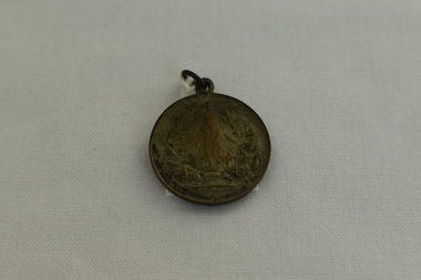
Small bronze medal made by Stokes & Son issued to Australian schoolchildren in 1919 at the end of WWI. Small bronze medal. The obverse has a figure of Victory, a female figure with flowing robes and hair, with doves flying around her head; there are two supine figures at her feet, and they appear to be breaking the chains of war. The reverse depicts a soldier and a sailor with a crown and laurel wreath. The laurel wreath encloses the inscription. The figures stand near a scroll. There is a small metal loop at the top of the medal to allow it to be attached to a ribbon or hung on a chain. -
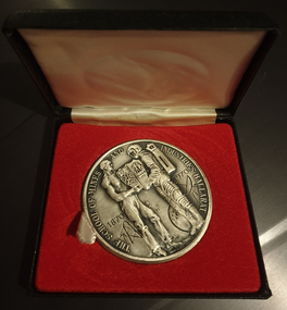 Federation University Historical Collection
Medal - Numismatics, Victor Greenhalgh, Ballarat School of Mines Centenary Medal (boxed), 1970, 1970
... Stokes & Son...Stokes & Son ..."A limited number of Centenary Medallions designed by Mr. V. Greenhalgh were produced by Stokes & Son, Melbourne to commemorate the Centenary of the School. The medallion was produced from copper base metal with a silver oxide finish and has been well received by past student, present students, staff members and the general public. A quantity of 50 medallions have been reserved for presentation purposes on special occasions."26 silver medals in a black hinged box. The medal struck for the Ballarat School of Mines centenary. . The School of Mines and Industries Ballarat 1870-1870 Verso Ingenio Effodere Opes A Centenary of Educaiton in Technology Science & Art ballarat school of mines centenary medal, centenary, anniversary, victor greenhalgh, stokes & son, medallion -
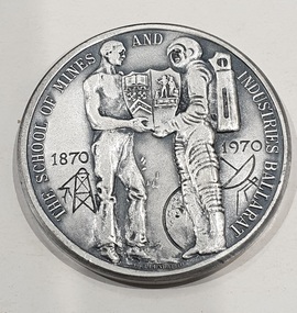 Federation University Historical Collection
Medal - Numismatics, Ballarat School of Mines Centenary Medal, 1970, 1970
... Stokes & Son ..."A limited number of Centenary Medallions designed by Mr. V. Greenhalgh were produced by Stokes & Son, Melbourne to commemorate the Centenary of the School. The medallion was produced from copper base metal with a silver oxide finish and has been well received by past student, present students, staff members and the general public. A quantity of 50 medallions have been reserved for presentation purposes on special occasions."Medal struck for the Ballarat School of Mines centenary. .1) Two framed centenary medals, showing both sides of the medal .2) Sterling silver medal in a black hinged box. .3) Booklet listing receipients of Centenary Medallion .1) Presented to Professor Geoffrey Blainey, AO Guest Speaker Founders Day 26 October 1995"ballarat school of mines centenary medal, centenary, anniversary, victor greenhalgh, geoffrey blainey, stokes & son, e.j. barker, g. biddington, e.j. tippett, sir paul hasluck, l.j.f. hillman, miss b. archdale, sir douglas menzies, h.j trudinger, m.b. john, b.r. hames, v. grennhalgh, r.w. richards, a. senior, j. clark, n. crouch, h. dixon, p. law, nigel bowen, peter lees, mrs j. lawn, dr. j birrell, d. kellock, g. dixon, john baker, k. kelly, w. anderson, w titteridge, a.e. stohr, r. chambers, g. smith, m.g. beanland, j.v. robertson, v. white, mrs m. scott, r cairns, p. zass, j. england, h. sienering, i.g. whitcher, v. lisle, edith lawn, dr stephen murray smith -
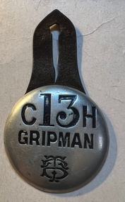 Melbourne Tram Museum
Badge - Gripman - 13 - Clifton Hill, Tramway Board, c1916
Use to identify a tramway employee - Clifton Hill car house or depot. Would have allowed free travel when in uniform to and from work. Used possibly from mid 1910's when the Tramway Board was formed until it was replaced by the MMTB in 1921 or when a different identification system was implemented. Most likely made by Stokes and Sons - possible imprint covered by the leather part.Demonstrates the method of identifying cable tram employees. Round pressed brass badge with the words "Gripman" pressed into the centre of the badge around the top portion of the badge, the letters "C13H. Has a nickel-plated finish with the Tramways Board logo on the lower part of the badge. On the rear of the badge, two metal lugs have been soldered onto the badge and a two-piece leather strap with a buttonhole cut into it to enable it to be worn on a uniform. Second copy - Nicholson St car house, No. 13. Third copy No. 25 for Clifton Hill. See item 7339 for a Conductor badge. badges, tramways, trams, employee pass, tramway board, clifton hill depot, gripmen -
Port Melbourne Historical & Preservation Society
Document - Correspondence, James J BARTLETT, 1920s - 1970s
Various documents from the Estate of James J BARTLETT (Full list attached to catalogue sheet).Rentals for multiple properties in Bay St, Heath St, Bridge St, Ingles St, Pickles St, Stokes St, Station St... Associated invoices and quotes. Brick factory specifications. Insurance policies and rate notices. Correspondence to J J BARTLETT and his son J C BARTLETT. Various items relating to J C BARTLETT from 1960s - bank records, gas and electricity bills. All held in dark brown archive box. built environment - domestic, james john bartlett, chapman & co, percy c mustow, lee mustow, william howe, w c trewavis, j r buxton, l w shaw, mustow and kemp, j c bartlett -
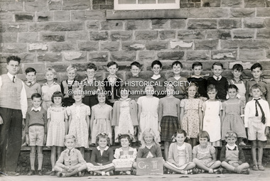 Eltham District Historical Society Inc
Photograph - Black and White Print, Rural Photographic Service of Australia, Grade III, Eltham State School 209, Dalton Street, Eltham, 1953
Teacher: Mr Griffith Back Row (L-R): Mr Griffith, - , - , John Hopkins , Ronny Morris, Michael Oldfield, Rex Jobling , -, - , - , Geoffrey Jones, Barry Moar, David Stokes Middle Row (L-R): - , Avis Barnes , Pam Geer , Prue Kimber , Dirkie Herholdt, - , Bronwyn Conibear , Joy Chapman , - , - , Alan Pittman Front Row (L-R): Neil Twyford , - , Beverley Bradbury (nee Stokes), Susan Gill , Helen Taylor , Thelma Baxter , - . Students in grade either not present or unidentified include Faye Helmers, David Knight, Robin Hayes, Bruce Treganan Photography by Rural Photographic Service of Australia, 8a Bankly Avenue, Malvern, Vic. 5303/5 Digital copies scanned by EDHS from originals held by Barry Moar, of Greensborough, Vic, 17 Jul 2017 and Margaret Harding (nee Joy Chapman.) 15 Nov 2024. Keith and brother Barry Moar moved to Eltham in March 1944 where they attended the State School (elder brother Keith from 1949) in Dalton Street. They lived at 11 York Street in a house rented from Ernie Andrew at a cost of £2/week. Other items of note advised by Barry and Keith Moar: Michael Oldfield was killed in a car accident in South David Stokes, son of Frank Stokes who operated Stokes Orchard was killed in the Black Saturday fire of 7 Feb 2009. It snowed in Eltham in 1952 or 1953 Andy Matthews was on HMAS Voyager when it was sunk by HMAS Melbourne. Carleen Golgeth's mother used to drive her to school in a c.1928 Rolls Royce taxi (phaeton?)Digital copy of black and white photograph x 21953, eltham state school, state school no. 209, grade iii, alan pittman, barry moar, david stokes, geoffrey jones, michael oldfield, mr griffith, neil twyford, ronny morris, margaret harding (joy chapman) collection, barry moar collection, arthur roberts, avis barnes, barry (andy) matthews, ben rutley, beverley bradbury (nee stokes), bronwyn conibear, bruce treganan, carleen golgeth, class photo, david knight, dirkie herholdt, dorothy uren, eltham primary school, eltham state school no. 209, faye helmers, grade v, helen taylor, ian newlands, john hopkins, john squires, johnny morris, joy chapman, keith moar, margaret butterway, margie? reed, marjory bredle, maureen davis, max goldsworthy, michael sinclair, mr jobling, mr phillips, nina macbeth, pam geer, pat davison, peter brown, peter mccann, prue kimber, rex jobling, robert eisma, robin hayes, stafford davison, susan gill, teddie mynott, thelma baxter, yvonne box -
 Eltham District Historical Society Inc
Photograph, The Stokes family home and orchard blanketed with snow, corner Nyora and Eucalyptus roads, Eltham, Winter 1951, 1951
... The Stokes family home and orchard blanketed with snow ...Taken from outside the family home on the southest corner of the intersection of Nyora Road and Pitt Street with Eucalyptus Road. Frank Stokes first traveled to the district by train in 1944 to find land with the intention to establish an orchard. By chance he met Arthur Bird of Bird Orchard (bounded by Pitt Street, Eucalyptus Road and Wattle Grove) and they got talking over their common interest. Arthur put Frank up for the night and pointed out the land, part of Crown Allotment 15, Section 5, Parish of Nillumbik (CA15) somewhat diagonally opposite Bird Orchard. Frank bought the land and for the next two years would travel by train from Melbourne to Eltham every weekend establishing Stokes Orchard and building a home for his family, which they eventually moved into in 1946. Marjorie North remembered well the winter of 1951, when she took children, including son John together with the Shallard and Squire children “in the Austin A40 up the Main Rd., Eltham to farmer Bell’s property alongside the Eltham College. They were able to make a snow man and throw snowballs. (Diamond Valley News, August 5, 1986.p.42) In the mid 1970s the Shire of Eltham divided the orchard up into numerous rate-able parcel lots, which became affordable for Frank. As a consequence Stokes Orchard was turned into a housing development by Macquarie Builders and marketed as the Stokes Orchard Estate in two stages; Stage 1 encompassing Scarlet Ash Court, Ironbark Close and Peppermint Grove bounded by Nyora and Eucalyptus roads c.1976 and Stage 2 encompassing Stokes Place, Orchard Way, The Crest and The Lookout bound by Nyora and Diosma roads c.1979. The development of Orchard Way, The Crest and The Lookout did not proceed as planned due to the lack of the sewer along Diosma Road and so many of the proposed lots were incorporated into five-acre parcels instead.Representative of the orchard growing areas of Eltham. One of the rare times it has snowed in Eltham.Digital file only - Digitised by EDHS from a scrapbook (containing commercially printed photos of digital scans) on loan from Beryl Bradbury (nee Stokes), daughter of Frank Stokes.1951, beryl bradbury (nee stokes) collection, eltham, nyora road, eucalyptus road, snow, stokes family home -
 Warrnambool and District Historical Society Inc.
Medal, Stokes and Martin, Rutledge Brothers, 1877
... Stokes and Martin ...This medal was made by Stokes and Martin. Thomas Stokes established a medal-making business in Melbourne in 1856 and from 1867 to 1893 he had a partner, George Frederick Martin. In 1962 the Stokes business became a public company and operates today in Melbourne. The medal was awarded at the Annual Show of the Villiers and Heytesbury Agricultural Association in 1877. One of the earliest agricultural associations in Victoria, the V.& H.A.A., the forerunner of the Warrnambool Agricultural Society, was established in 1854 and the first Warrnambool Show was held in 1855 at the first Royal Archer Hotel in Koroit Street. The Warrnambool Agricultural Show is still held annually. The medal, first prize for the best horse hay rake, was awarded in 1877 to the brothers, Thomas and William Rutledge, sons of Eliza and William Rutledge. The latter was a pioneer settler who came to the Warrnambool/Port Fairy district as the purchaser of the Special Survey, Farnham Park in 1841. His land stretched from Tower Hill to Dennington. William Rutledge Senior was a pioneer breeder of a Lincoln sheep stud, the owner of a mercantile business in Port Fairy, a member of the Legislative Council of Victoria and the pioneer developer of farming land around Tower Hill. His son Thomas (1846-1918) was a Warrnambool Shire Councillor who farmed in the Farnham Survey, living at Werronggurt . He went to the Geelong area at the end of the 19th century. His brother William (1849-1935) also farmed in the Farnham Survey, living at Farnham Park, He later lived at Airlie in Henna Street, Warrnambool and Sherwood on the Hopkins River and had land in the Otway Ranges. He later went to New Zealand.This medal is of considerable significance because of its age and its association with Thomas and William Rutledge and with the Villiers and Heytesbury Agricultural Association.This is a bronze medal with an image of agricultural implements, agricultural produce and farm animals on one side and etched printing on the other side. There is also printing around the edge of the medal. The medal has a small hole at the top for attaching the medal to a cord. Villiers & Heytesbury Agricultural Association 1st Prize awarded to Rutledge Bro. for Horse Hay Rake Annual Show Warrnambool 10 Oct. 1877 Stokes & Martin Melbourne thomas and william rutledge, farnham special survey, villiers and heytesbury agricultural association, warrnambool agricultural society, history of warrnambool -
 Wodonga & District Historical Society Inc
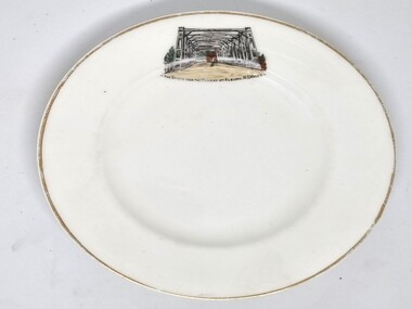
Souvenir - Souvenir Plate - Union Bridge, Albury, Hancock and Sons, c1930s
... Hancock and Sons ...This item is from a collection donated by descendants of John Francis Turner of Wodonga. It is one of many souvenirs produced to represent landmarks in the Albury-Wodonga district. The first punt across the Murray River at Albury was established by Robert Brown in 1843. In 1861 the first Union Bridge was built. It was demolished to make way for the second Union Bridge which opened in 1898. This second bridge closed and was eventually demolished after the third and existing bridge was opened in 1961. Hancock and Sons, Stoke on Trent - Sampson Hancock, a prominent Wesleyan Methodist, started potting in 1857. In 1891 he established the business of Sampson Hancock & Sons. Sampson died in 1900 and the business was continued by his three sons - Jabez, Harry and Arthur. In 1935 the business was in financial difficulty and was made bankrupt. It was restarted as S Hancock & Sons (Potters) Ltd. and moved to the Gordon Works, Hanley - which was renamed the Corona Works. The restarted company was not a success and it finally closed in 1937, having been put into receivership on 23rd March. This information helps to establish provenance of this plate.This item comes from a collection used by a prominent citizen of Wodonga. It is representative of a items produced to represent historic landmarks or features of the district.Fine China round plate with gilt edge and image of the Union Bridge, AlburyBeneath image: " THE BRIDGE OVER THE MURRAY AT ALBURY, NSWALESalbury souvenirs, union bridge albury, albury-wodonga border, murray river bridges -
Glenelg Shire Council Cultural Collection
Medal - Medal, Royal Visit of Queen Elizabeth II, c. 1954
Commemorative medal commissioned by the Victorian state government as a souvenir of the Royal Visit by Queen Elizabeth II and the Duke of Edinburgh to Victoria in 1954. The medal was presented to all Victorian school children. It was struck by Stokes & Sons of Melbourne. The Queen and Prince Philip visited Victoria from 24 February to 9 March 1954. The first reigning monarch to tour Australia, she arrived in Sydney on 3 February 1954 and departed the country from Fremantle on 1 April 1954. The Royal party visited all the capital cities apart from Darwin, and over 70 country towns.Bronze medal, hanging from a rectangular bar. The obverse of the medal features profile portraits of the Queen and Prince Philip. Presented to children of Victoria on Royal Visit, 1954Obverse: bust of Elizabeth II and Duke of Edinburgh Reverse: E II R Royal Visit/ 1954/ Victoriamedal, queen elizabeth ii, 1954, royal visit, victoria, numismatics, celebrations, schools -
Frankston RSL Sub Branch
Medallion
The medal was created for sale to the public to raise funds for the provision of troop comforts material.Medallion distributed during World War 1 by the South Australia Division of the Australian Comforts Fund. This medallion was apparently used for fund raising by the ACF to support the welfare of Australian service personnel. The medallion is 52mm diameter by 5mm thick and is made from copper. The medallion has a swivel and a loop at the top for attaching a chain or ribbon. Mintage total not known. The Reverse side of the medallion is embossed with the words "New Guinea", "Egypt", "Gallipoli", "France", "Palestine", "Salonika" and "Mesopotamia" within an olive wreath. The obverse side of the medallion has an embossed image of the head and shoulders of an Australian soldier wearing a slouch hat and carrying a rifle at the high port position. The edge of the medallion is stamped "Australian Comforts Fund SA Division". Medallion has suffered edge damage and has been cleaned extensivelyThe reverse side of the medallion is embossed with the words "New Guinea", "Egypt", "Gallipoli", "France", "Palestine", "Salonika" and "Mesopotamia" within an olive wreath. The obverse side of the medallion has an embossed image of the head and shoulders of an Australian soldier wearing a slouch hat and carrying a rifle at the high port position. The edge of the medallion is stamped "Australian Comforts Fund SA Division". Stokes & Sonsww1, medallion, south australia, acf, australian comforts fund -
 City of Moorabbin Historical Society (Operating the Box Cottage Museum)
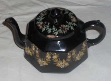
Domestic object - Kitchen Equipment, Tea Pot, Between 1885 and 1905 after which the backstamp changed to G & S LTD
... G & S . ( Gibson& Sons Ltd or Grove & Stark Ltd) ...Earthenware is lightly fired, readily absorbs water if not glazed, and does not allow light to pass through it. Coarse earthenware is made from clay and grog (ground up fired pot). There are two main types of glazed earthenware: One is covered with a transparent lead glaze; when the earthenware body to which this glaze is applied has a cream colour, the product is called creamware. The second type, covered with an opaque white .in glaze, is variously called tin-enamelled, or tin-glazed, earthenware, majolica, faience, or delft. G&S marking could be Grove & Stark, Longton, England (1871-1884). In the 19th century, J. & G. Meakin ,1851 based in Hanley, Stoke-on-Trent, Staffordshire, was known for the vast quantities of cheap ironstone china it produced for the domestic English market and for export to Australia, Canada, New Zealand and the United States. Grove & Stark were taken over by Meakin early 20thC The Mark could also be Gibson & Sons (Ltd), were notably manufacturers of earthenware Burslem, Stoke-on-Trent. Founded around 1885 and traded until the mid 1970's. They were previously Gibson, Sudlow & Co. Manufactured between 1885 to 1905. Small earthen-ware, black-glazed tea-pot. 8 sided. The body of the tea-pot is decorated with hand-painted gold flowers and raised cream flowers. The lid is also hand -painted with green leaves and flowers. This floral pattern is named "Garland" The lid is not of the same pattern as the base. The spout was broken when brush tailed possum entered Cottage via chimney 27/4/2014. Can be repairedOn the base of the tea-pot. Makers Mark is G & S. "Garland". (Pattern), Rg. No. 175153. Also 'Made in England'. Under glaze there is the word: England.crockery, earthenwarre, gibson & son ltd, grove & stark ltd, pioneers, early settlers, bentleigh, market gardeners, moorabbin, cheltenham, pottery, stoke- on - trent, england, longton, burslem, wedgwood -
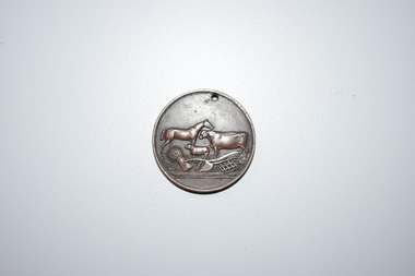
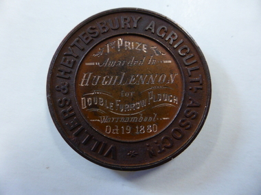 Warrnambool and District Historical Society Inc.
Medal - Medal VHAS, Villiers and Heytesbury Agricultural Association, Circa 1880
Historical information: this medallion has historical details on three fronts. Firstly the Villiers & Heytesbury Agricultural Association. This association began with the first meeting held on May 17th 1853 at Woodford. The minutes of that meeting read “That in the opinion of this meeting, the formation of an agricultural association would be of great benefit to persons in this district engaged in farming and pastoral pursuits. It initially embraced the following: ploughing, agricultural produce, machines and implements, and livestock of all descriptions. The first show was held at Warrnambool on April 10th 1855 on a green bounded by Fairy, Henna, and Koroit Streets. It was held there until 1875 when it moved to the present Showgrounds site in Koroit Street. At the 37th Annual show in 1890 Warrnambool held its first Grand National Show, being granted by the Chamber of Agriculture in turn, in Victoria. It became known as the Warrnambool Agricultural Society in 1911. Secondly the winner, Mr Hugh Lennon. He was one of the most successful innovators and manufacturers of agricultural implements in early Australia. Although born in Ireland, he served an apprenticeship in Scotland in mechanical engineering. The Lennon plough became known Australia wide. For many years he operated his business at the northern of Elizabeth Street in Melbourne. He was active in local affairs. He died in 1886 at the age of 52. Thirdly, Stokes and Martin. Thomas Stokes came to Australia in the 1850’s and established a successful business at Mincing Lane Melbourne, manufacturing buttons, medals and tokens. Martin joined the partnership in 1873, which lasted until a disastrous fire in 1893. The business was renamed Stokes & Sons Pty Ltd and it became a public company in 1962. It is currently situated at Ringwood in the business of spare parts for electrical equipment The Villiers and Heytesbury Agricultural Association was a significant event and organisation within the Western District over a large number of years. It was one of the earliest organisations in the district and is testament to its importance to the agricultural, social, and cultural life of the district. It is significant that this particular medallion was awarded to an innovator in the ploughing industry and that it was made by a company which is still in business 130 years later. Circular copper medallion cast with Villiers & Heytesbury Agricultural Assoctn around edge with winner and event details engraved in centre. The reverse is cast with horse, cow and sheep standing above wheat sheaf and farm implements. The edge of the medallion is plain.Villiers & Heytesbury Agricultl Assoctn around rim. 1st Prize awarded to Hugh Lennon for double furrow plough, Warrnambool Oct 19 1880. Stokes & Martin Melbourne in small lettering on the reverse.warrnambool, villiers & heytesbury, hugh lennon, stokes & martin, lennon plow, lennon plough -
 Flagstaff Hill Maritime Museum and Village
Ceramic - Serving Plate, Edward Challinor, Circa1862-1891
The pottery was at Fenton, Stoke on Trent, Staffordshire UK and was established in 1825, by C J & GM Mason, they were succeeded by Mr. Samuel Boyle from whom the works passed into the hands of E & C Challinor, formally E Challinor & Co. Of Sandyford and Tunstall. The partners in Sandyford and Tunstall works are recorded as Edward Challinor Jnr and Charles Challinor Jnr and is presumably they are the sons of the partners of the Fenton pottery business. They produced china of white granite, printed sponged common earthenware for the American, Australian, and other foreign and colonial markets. The main goods produced were tea, coffee, breakfast, dinner, and toilet ceramic sets as well as other earthenware goods. Their pottery marks were the Staffordshire rope knot with or without E & C Challinor or just E C. An early piece of earthenware pottery made in England for the Australian colonial market around the mid to late 19th century.Serving plate white body, smooth rim, and blue oriental designRope knot motif printed on back in blue with letters EC warrnambool, shipwrecked-coast, flagstaff-hill, flagstaff-hill-maritime-museum, shipwreck-coast, flagstaff-hill-maritime-village, earthenware, ceramic, willow pattern, serving plate, e & c challinor, potteries -
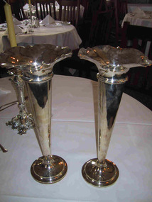 Parks Victoria - Mount Buffalo Chalet
Vase
Silver plated vase which was part of the Dining room silver service settings . 'When the Victorian railways took over managemen of the Chalet from 1 october 1924, they ran their dining room and cafe in similar fashion to the dining cars on their trains and refreshment rooms on their stations, using the same ceramic hotel-ware and electro plated nickel silverware (EPNS), all made to order items that are clearly idenitified by the distinctive 'VR' monogram. The Chalet retains a good selection of of the diverse range of EPNS item formerly used in the dining room..- which in all their variety and function help to interpret the dining room protocols of the 'tourist house' and the service provied by the Victorian Railways refreshment and Services Branch. Many of the items were manufactured by by Stoke & Sons of Melbourne (est. 1856.' (Pg 103. Historica) Listed in Draft Inventory of Significant Collection items. Appendix A.3.Tableware. (Pg 166 Historica).Two fluted electroplated silver vases with Victorian Railways insignia and a number at base."VR" and more... -
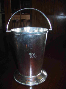 Parks Victoria - Mount Buffalo Chalet
Bucket, ice
Part of the Victorian Railways silver service. When the Victorian railways took over management of the Chalet from 1 October 1924, they ran their dining room and cafe in similar fashion to the dining cars on their trains and refreshment rooms on their stations, using the same ceramic hotel-ware and electro plated nickel silverware (EPNS), all made to order items that are clearly idenitified by the distinctive 'VR' monogram. The Chalet retains a good selection of of the diverse range of EPNS items formerly used in the dining room..- which in all their variety and function help to interpret the dining room protocols of the 'tourist house' and the service provided by the Victorian Railways refreshment and Services Branch. Many of the items were manufactured by Stoke & Sons of Melbourne (est. 1856.)' (Pg 103. Historica) Possibly once graced the chrome display cabinet.Listed in Draft Inventory of Significant Collection items. Appendix A.3.Tableware. (Pg 166 Historica).Small ice bucket. Electroplated silver on nickel. Has a handle to carry and wide pedestal base."VR" insiginia engraved on front of bucket.Crown with scroll underneath with "Victorian Railways" Under that,"WHITE - THROUGH / E.P \ A1\ N.S" -
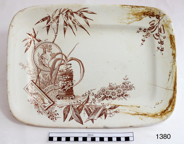 Flagstaff Hill Maritime Museum and Village
Dish
... A. F. & S. (Alfred Fenton & Sons) ...The maker’s initials on the back of the patter, “A.F. & S.” are one of the marks of Alfred Fenton & Sons (& Co) of Brook Street Works (renamed Century Street in 1950’s), Hanley, Staffordshire, Stoke-on-Trent in the United Kingdom. The partners were Alfred Fenton, James Tunstall Fenton, Arthur Fenton and John Fenton. Other initials used are “A F & Co.” The company operated from 1887 to 1901. According to the London Gazette of January 10, 1899, the Earthenware Manufacturers “Alfred Fenton & Sons“ also had a location in Australia at the corner of Elizabeth Street and 314-316 Bourke Street Melbourne Victoria, and Bond Street, Sydney, and in New Zealand at Manse Street, Dunedin. The maker’s mark also includes the word ‘PRAHRAN’, which is an inner suburb of Melbourne. “Prahran” may have been the name of this particular pattern or even the location chosen in preference to the location ‘Melbourne’. The Melbourne address was purchased from a long established drapery business, Wright and Neil, between 1911-1914 by Sidney Myer. Myer constructed his 1914 building in on this site in Bourke Street. This platter is an example of late 19th or early 20th century dinnerware.Dish; white ceramic rectangular platter with picture in brown ink depicting vegetation (including bamboo and blossoms), flower pot, plates and two oriental persons. Made by Alfred Fenton and Sons 1887-1901.Stamped on back, "PRAHRAN / A.F. & S." surrounded by a buckled belt. Number "14" printed in the clay. flagstaff hill, warrnambool, shipwrecked-coast, flagstaff-hill, flagstaff-hill-maritime-museum, maritime-museum, shipwreck-coast, flagstaff-hill-maritime-village, dish, food perparation, dinnerware, catering, a.f. & s., a fenton and son potters of hanley uk, bourke street melbourne, prahran dinnerwear -
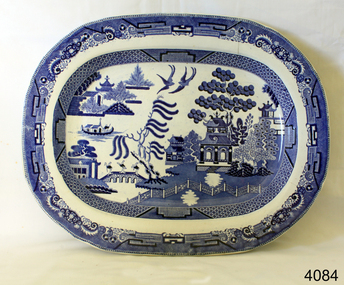
 Coal Creek Community Park & Museum
Bottle, glass, c.1887- c.1903
... W.A.Stokes (William Albert Stokes) ...Victorian Government gazette, Wednesday January 28, 1902, page 20. 'The Pharmaceutical Register cont'd.........No. on register : 140, Date of registration : 30 May 1877, Stokes, William Albert, Balaclava Road, East St. Kilda, Qualification : in business in Victoria before 1 October 1876'. TROVE : Argus (Melbourne, Vic. : 1848 - 1957), Tuesday 7 September 1875, page 1. 'WANTED, a respectable BOY ; must live in the neighbourhood. References W. A. Stokes, chemist, Balaclava'. TROVE : Bendigo Independent (Vic. : 1891 - 1918), Tuesday 1 December 1914, page 5. 'ABOUT PEOPLE. The death of Dr. James Stokes, M.R.C.S., L., occurred at his home, 43 Ebden Street, Elsternwick, on Saturday at the age of 90 years. Dr. Stokes, who was born in London,, arrived in Victoria in 1849 and for many years practiced in different parts of the State. He was the last on the male side of an old family, one of his sons, who predeceased him, being the late Mr. W. A. Stokes, chemist, of Carlisle Street, St. Kilda. The funeral took place yesterday morning, when the remains were in interred in the family grave at St, Kilda Cemetery'. TROVE : The Age (Melbourne, Vic. : 1854 - 1954) Tuesday 13 December 1887 p 5 Article " ROUGH ON RATS" POISON.' . PROSECUTION UNDER THE POISONS ACT. At the St. Kilda police court, on Friday, W, A. Stokes, chemist, Carlisle-street, Balaclava, was prosecuted under the Poisons Statute on the charge of selling to one Mrs. Hannah Charlton a poison without having made and signed the entry required by the act. A second charge of selling to Mrs, Hannah Charlton a poison without having obtained the signature of the purchaser to an entry as required by the act was also preferred against the defendant. Both cases were taken together. Mr, Donovan appeared to prosecute, and Mr. Cole for the defence. Senior-constable Connell deposed that he knew the defendant. On the 24th of October last an inquest was held at East St. Kilda relative to the cause of the death of a man named Charlton. A packet bearing the label " Rough on Rats," which was found. in the deceased's bedroom, was produced at the inqiry, and afterwards handed over to Mr. Blackett, Government analytical chemist for analysis. The verdict of the jury was that the deceased died from the effects of arsenical poisoning. Hannah Charlton, a widow, residing in South Yarra, said in September last she purchased a packet of "Rough on Rats" from the defendant's assistant. Witness was not asked her name, place of abode, occupation or for what purpose the poison was required; neither did she observe the assistant make any entry in a book, She did not attach her signature to any document, and was not asked to do so. The packet was purchased for the purpose of poisoning rats. Cuthbert Robert Blackett, Government analytical chemist, stated that Constable Ballantyne handed him the packet produced. Witness made an analysis of the contents, and found it composed of arsenic, slightly coloured with a carbonaceous matter. The mayor announced that there was a doubt in the minds of the magistrates as to whether the defendant could be held guilty under the law, but they thought the prosecution had attained its object by making known the fact that "Rough on Rats" is a poison. They thought that such preparations should be entered by the sellers, but in that case they were inclined to give the defendant the benefit of the doubt and dismiss the case.Aqua tinted clear glass bottle with angled corners for stopper seal with text embossed on one side and on base.On side : 'W.A.STOKES CHEMIST EAST ST. KILDA'. On base : 'K6228'.w a stokes, chemist -
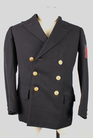 Warrnambool RSL Sub Branch
Royal Australian Navy Jacket
Double-Breasted lined jacket with 'wing' lapels. Left and Right pockets with cover flaps. Colour; Dark Navy. Petty Officer Badge (slightly faded) near shoulder of left sleeve.All Buttons Metal. Buttons Reverse; Stokes and Sons Melb. 6 Buttons on front; 23mm diameter. 2 Buttons on each sleeve cuff; 15mm diameter. All buttons show Crown and Anchor with 'Australia' beneath. Inside; 1 pocket on right side. 2 pockets on left side (i pocket small 'coin' or 'pocket watch' size). Inside neck; original fabric tag covered by 'Band-Aid ' sticker with the words 'G' or 'E' Cole per 13 Heeds'. -
 Eltham District Historical Society Inc
Document - Certificate of Title, Landata, Vol. 4930 Fol. 985900, Crown Portion 15 Section 5, Parish of Nillumbik, County of Evelyn, 1925
(Cancelled) Certificate of Title originally issued for Crown Portion 15, Section 5 to Robert David Taylor, of Eltham, County of Evelyn, Farmer, 13 March 1925. It is with this title that the land allotment was subdivided into 48 lots. The title shows the issuance to Robert David Taylor with encumbrance placed upon it by immediate former owner, Hugh Patrick Keogh, a former member for Gippsland and Melbourne Real Estate Agent. Following Taylor's death in 1934 the title passes to his Executors, sons Robert David Taylor of Bible Street, Eltham and William McLelland Vance Taylor of Northcote. The property is then sold to Frank Stokes who develops the Stokes Orchard. Compulsory acquisitions by the Melbourne Metropolitan Board of Works and State Electricity Commission show provisions of easemenst for town water supply and high voltage power transmission lines. Subsequent lots are then sold off with the development of the Stokes Orchard Estate residential development in the mid to late 1970s. A History of the Development of Crown Allotment 15, Section 5, Parish of Nillumbik – Stokes Orchard Crown Allotment 15, Section 5, Parish of Nillumbik (CA15) is a square allotment of 158 acres or approximately a quarter of a square mile. It lies just beyond the eastern end of Pitt Street, south of Nyora Road to the northern end of Eucalyptus Road and extends east from Eucalyptus Road to Reynolds Road. The topography of CA15 is generally steep, sloping up to a hill near the centre of the land, the ridgeline passing through the properties along the southern side of Diosma Road. Eucalyptus Road is a straight north-south road with its northern end at the north west corner of CA15. Until the end of the 1970s this road was an un-named Government Road and was largely not open to traffic. With residential development in the 1970s the road was constructed, and the council allocated the name obviously in recognition of the predominant species of the local bushland. CA15 was purchased from the Crown by George D’Arley Boursiquot, a prominent Melbourne printer, on 28th October 1852. On November 23, 1922, former Member for Gippsland and Melbourne Real Estate Agent, Hubert Patrick Keogh purchased the allotment then sold it March 13, 1925, to local farmer, Robert David Taylor, a former Shire of Eltham Councillor (1911-1920) and Shire President (1919). Taylor had extensive land holdings stretching west towards Bible Street and Main Road. The Taylor home was situated at the top of the hill in Bible Street at present day 82 Bible Street. At the time of Taylor’s purchase in 1925, CA15 was subdivided into 48 lots that could be described as small rural properties or large residential lots. A typical lot size was one hectare or 2.5 acres. The subdivision created two roads, Nyora Road, and Diosma Road, each following an irregular alignment between Eucalyptus and Reynolds Roads. However, the lots were not sold off separately nor were the roads constructed. The land effectively remained as one parcel for many further years. Robert David Taylor died November 30, 1934, and probate was granted to his son of the same name, Robert David Taylor of Bible Street, Salesman and William McLelland Vance Taylor of 73 Emmeline Street, Northcote, Clerk, with the transfer of the land into their names on July 8, 1935. Frank Stokes worked as a qualified accountant at Kennons leather factory in Burnley, while living at 1 Thomas Street, Mitcham. He suffered from migraines and wanted to return to working the land (he had previously worked on farms and orchards since coming to Australia from England in 1926, both in WA and Vic.). He first travelled to the district by train in July 1942 to find land with the intention to establish an orchard. By chance he met Arthur Bird of Bird Orchard (bounded by Pitt Street, Eucalyptus Road, and Wattle Grove) and they got talking over their common interest. Arthur put Frank up for the night and pointed out the land, 158 acres- part of the Taylor Estate- £900, Crown Allotment 15, Section 5, Parish of Nillumbik (CA15) somewhat diagonally opposite Bird Orchard. Stokes applied through the Riverina Agency to purchase the land who in turn applied for permission from Canberra to sell as there was a new government regulation introduced during the Second World War banning land sales except for immediate production. Stokes obtained a loan on his Mitcham house of £600 @ 5% and paid £450 deposit with quarterly payments of £15 spread over 5 years. Stokes was assisted and advised by Arthur Bird who farmed the neighbouring orchard. In early 1943 Stokes took possession and would catch the train out to Eltham on Fridays after work and began building a hut on the corner of Nyora Road and the Government Road (Eucalyptus Road) for shelter and to lock up tools. He established an orchard on the central western part of the land through the centre of which ran a natural waterway (part of the present-day linear park) and was able to pay a neighbour (Hawkins) to help with clearing and fencing 25 acres, and with a horse and single furrowed plough, planted approximately 2,500 fruit trees - cherries, peaches, plums, almonds, pears, apricots and lemons as well as a few apples and oranges; a massive task. Aerial photographs from the 1940s through to the 1990s clearly show the orchard with most of the larger CA15 site remaining as natural bushland. A huge problem was hares and rabbits eating all the new buds off the tiny trees. As well as laying poison he painted the trees with a mixture of cow manure and lime, often working by moonlight. Procurement of wire and wire netting was difficult because of the war but after much effort he obtained a permit from the Agricultural Department for supplies in March 1944. In February 1945 Stokes applied for a permit to build a “packing shed” as no house building was allowed. It was to be 33 feet x 21 feet and cost £312. It was constructed mostly from second-hand materials, which were hard to obtain, especially iron for roofing. Stokes finished work at Kennons on October 31, 1945, and in March 1946 he sold the family home at Mitcham for £1,230 plus £170 for furniture. On May 15, 1946, title to the CA15 property was issued to Frank Howard Alfred Stokes, Orchardist and Gladys Ethel Stokes, Married Woman, both of Pitt Street, Eltham. The family of five then moved into the very unfinished “packing shed” at Eltham, which was a struggle to weatherproof. Eventually rooms were divided off and lined with hessian bags and whitewashed. Their income was firewood (cut and sold), selling rockery stones and cut Sweet Bursaria. (It was discovered during the 1940s that Sweet Bursaria contained the sunscreen compound Aesculin. The RAAF utilised this compound from Sweet Bursaria during WW2 for pilots and gunners.) The orchard’s first fruit sale was a half-case of Le Vanq peaches in December 1947 for the price of 8 shillings. In 1956 plans for house were drawn and Glen Iris bricks purchased (1956 Olympic Rings variant). The building of the house commenced in 1957 - 12 feet of original packing shed was removed – and was completed in 1959. Water was connected from newly built pressure storage on the property at the end of 1959 and the electricity connection for the first time at 3pm on April 29, 1960. The house remains to present day (somewhat modified) at 1 Nyora Road, home to Nyora Studio Gallery. On occasions, spare remnants of the 1956 bricks have been known to be unearthed in gardens on the estate as they were utilised by Frank Stokes to fill in rabbit holes. On May 26, 1950, a parcel of land was compulsorily acquired by the Melbourne and Metropolitan Board of Works on the hilltop to establish an easement for a high-level service reservoir to augment Eltham’s water supply. The project also included pipe tracks for the necessary water mains. The reservoir has now been superseded by higher level water tanks east of Reynolds Road and its former site is now a public reserve. On November 27, 1964, the State Electricity Commission served notice to compulsorily acquire a further parcel through the eastern part of the land for a major electricity transmission line that augmented supply from the La Trobe Valley to Melbourne. The easement was registered February 11, 1966. The easement was widened July 18, 1969 for a second transmission line to be constructed. In 1971 Melbourne Metropolitan Planning Scheme amendments adopted Nyora Road as the boundary between a residential zone to the north and a rural zone to the south. This determined the future development of the land. In the mid-1970s the Shire of Eltham divided the orchard into numerous rate-able parcel lots, the 48 lots having been established in 1925 and the subsequent rates assessment proved unsustainable for Stokes. He commenced selling lots outside the boundary of the orchard, north of Diosma and South of Nyora. However shortly later the land between Nyora and Diosma Roads and west of the electricity easement was sold and subdivided into residential lots, a housing development by Macquarie Builders and marketed as the Stokes Orchard Estate. New streets were created, and most were named after trees, although one, Stokes Place, commemorates the former owners. The development was undertaken in two stages; Stage 1 (1975) encompassing Scarlet Ash Court, Ironbark Close and Peppermint Grove bounded by Nyora and Eucalyptus roads and Stage 2 (1978) encompassing Stokes Place, Orchard Way, The Crest and The Lookout bound by Nyora and Diosma roads. The developer, Macquarie Builders went bankrupt shortly after the release of Stage 2 leaving many purchasers to fend for themselves and arrange for their own independent builders. There were also difficulties with sewerage for the land immediately south of Diosma Road and so the conventional residential lots were abandoned in favour of larger lots. The development of Orchard Way, The Crest and The Lookout did not proceed as planned and the proposed lots were incorporated into five-acre parcels instead. These included a low-density group housing development by the Graves family and the award winning Choong House (1983) with Gordon Ford developed garden immediately next door situated on the ridge of the hill nestled amongst the original bush, Eucalypt trees and Sweet Bursaria. In 1994, Nillumbik Shire Council applied Significant Environment and Significant Landscape overlays upon the properties on the south side of Diosma Road to ensure protection of this natural bush garden environment. With the arrival of the sewer along Diosma Road in the 1990s, most of these five-acre parcels have since been subdivided multiple times. The Choong house presently sits on a 2.7-acre property, which in 2022 Nillumbik Council nominated for Cultural Significance Heritage protection and is considered potentially significant at State level. The Stokes family were also associated with the Eltham Christian Church. In the 1970s this church had met in temporary premises in Eltham. Lots of the original 1925 subdivision remained south of Nyora Road and a number of these lots were utilized for the Eltham Christian School, which was established by the Eltham Christian Church in 1981. The school operated on this site until 2000. The premises are now used by The Vine Baptist Church. By the mid-1980s the whole of CA15 had been developed for residential and school purposes, except for the sections north of Diosma Road and between the transmission lines and Reynolds Road. Sewerage issues had been resolved for the section north of Diosma Road and in 1987 it was in the process of being subdivided into residential lots. The development coincided with the discovery of colonies of the rare and endangered Eltham Copper Butterfly on the site. This resulted in a community and political campaign to save the butterfly habitat. With the co-operation of the land developer the subdivision was altered to create two bushland reserves in the critical butterfly habitat areas. In the late 1980s the State Government was investigating options for establishing a metropolitan ring road link between Diamond Creek and Ringwood. The chosen route was adjacent to Reynolds Road and so this created a freeze on development of CA15 between Reynolds Road and the electricity easement. The ring road proposal was eventually abandoned, and this part of the land was subdivided into low density residential lots. Diosma Road has been discontinued at the electricity easement and the eastern part incorporated into View Mount Court with access from Reynolds Road. The whole of CA15 has now been developed for residential or associated purposes, ranging from conventional density to quite low density south of Nyora Road. Some remnants of the orchard remain, a few cherry trees on the Graves property and a lone apple tree in Stokes Place. The butterfly reserves comprise significant areas of remnant bushland. Linear reserves through the estate link with central Eltham via the Woodridge linear reserve and with Research along the electricity easement. CA15 as it exists today has a complicated history of rural use, Government acquisition, urban development, and community action. References: • “Stokes Orchard, an incomplete history”; Russell Yeoman with Doug Orford • Correspondence, Beryl Bradbury (nee Stokes) • Aerial Photographs, 1931-1991, Landata (landata.vic.gov.au) • Certificate of Title, Vol. 4930 Fol. 985900 • Plan Number LP 10859 neil webster collection, diosma road, eltham copper butterfly, eucalyptus road, ironbark close, nyora road, peppermint grove, power transmission lines, reynolds road, scarlet ash court, stokes orchard estate, stokes place, woodridge estate, frank stokes, certificate of title